
-
 4419 Hits
-
 75.81% Score
-
 6 Votes
|
|
Route |
|---|---|
|
|
46.35060°N / 14.40910°E |
|
|
Hiking |
|
|
Summer, Fall |
|
|
Most of a day |
|
|
Easy hike up |
|
|
Rating of the Tour (By Hiking Standards)
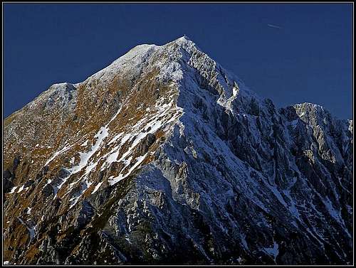
East ridge
The grading system for hiking and scrambling routes is here.
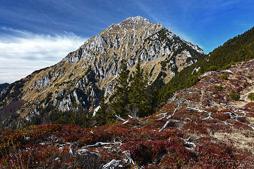
This is the most used ascent route on Storžič and also one of the easiest.
0. General: From 600 m on 2132 m, the slopes are turned towards S and SE. Till Kališče hut mostly through the woods, then to Bašeljsko sedlo (saddle) by a broad, well beaten path, finally over steep grassy and partly rocky slopes on top. Gear: Good hiking shoes and poles. By the Swiss Scale for hikes, the difficulty would be T3.
1. Effort: cca 1550 m, 4 h.
2. Power: 1 - No difficulties, only walk-up.
3. Psyche: 2 - Easy.
4. Orientation: 1 - No difficulties.
Overview and Getting There
Dom na Kališču, 1540 m, can be reached by several marked and also non-marked paths. They are described below, but also approaches from the distance (east and west) are possible.
See the main page of Storžič how to get to Preddvor and above it Mače village where on the altitude of 600 meters the trailhead is. From Mače we drive a bit more further up, the parking place is in the woods. Some people drive even further up (despite the sign prohibiting that) and along the creek of Suha till the parking place at the lower station of Kališče material cable way (some 800 m of altitude).
The other two trailheads are: The village Bašelj and the parking place above the village Laško.
Routes on Kališče
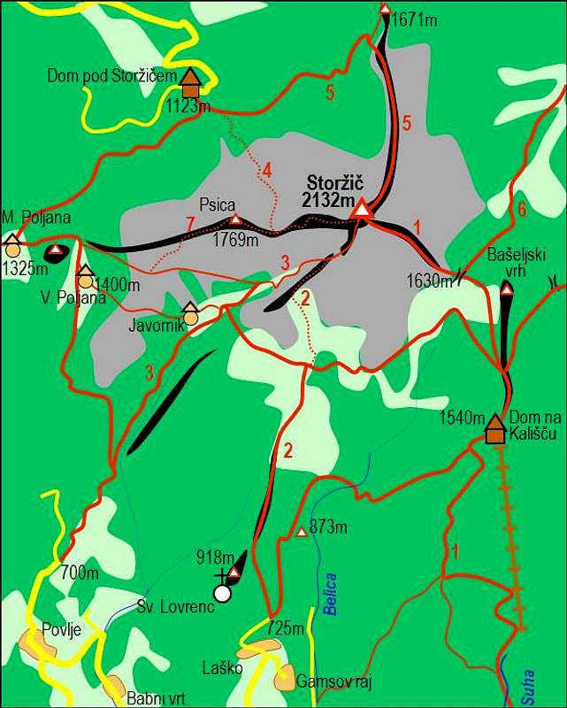
Storžič and its marked paths
1. From the parking place above Mače we hike up by the road into Suha creek valley. Near the lower station of materil cable way the marks (and cart-road) turn a bit left, so we hike up through the woods. Till the flat part of the trail, where the cart road ends we can also get by the old marked trail which deters left from Suha creek and goes more by the southers slopes.
On the flat part the joint trail goes horizontally through a dense forrest and reaches the forrested slopes of Kališče hill. There, the path goes up in several broad turns, finally exiting on the ex alpine meadow (that is Kališče). The mountain hut is still some 75 altitude meters up on a panoramic place. Difficulty: T2.
2. From Bašelj. In the upper part of the village there's an inscription directing us towards the mountain hut. The trail goes first right, then left up over the forrested slopes. Higher it turns over into the slopes of Belica creek, even descends a bit, but soon turns right again and joins the path from Mače at the end of the horizontal section. Difficulty: T2.
3. From Belica creek valley. Above Laško village we can drive by a steep road till some 715 m, where below Sv. Lovrenc church there's a parking place. Again, some people drive even further up into the valley of Belica creek. From the parking place we hike up by the mountain road, pass the Gradišče hill (archeological site), and reach the creek bed. There, one path (also marked) goes left to the ex Partisan hospital (from the World War II), the other path crosses the creek and starts ascending over the slopes on the other side. The two paths join some 250 m higher on the forrested ridge and after several turns through the woods up the joint path reaches Kališče meadow and in next 15 minutes the hut. Difficulty: T2.
Several other approaches to the mountain hut are possible, for example: From the lower station of the material cable way directly right up and on the side ridge of Kozjek, then by it to the horizontal path which comes on Kališče from the east, from below Zaplata.
Summit Ascent


From Kališče mountain hut we go by a broad path, cut through pine bushes on Bašeljsko sedlo (saddle), 1631 m. There, from the north, the path through Reka valley comes up.
From the saddle the path starts winding up through a section of pine bushes. Higher, the eastern ridge becomes more narrow, the path finds its passages through steeper grassy sections and a few rocks. The path is not demanding, only when icy it requires additional care (and equipment). Even higher, already close to the summit, we reach a panoramic shoulder, we go by the grassy slope left of the ridge, reach the summit rocks and the path goes steeper over them again. In a few minutes we are on the top. From the hut 1 h 45 min, T3.
Belica Ravine
If we are already in the valley of Belica creek, how about continuing directly up by its ravine, instead of going right around on Kališče? Temptation once got me there and I found a quite non-attractive option of ascent. Above the ex World War II Partisan hospital (it is a bit left, westward of Belica creek) the ravine is still fine. But above it is damn steep and ugly. Overgrown, wet, you often need to crawl up by a grassy and partially rocky slope. Don't go alone there - nobody will pass by in that corner for weeks! Climbing is not needed, but already some 150 m below Bašeljsko sedlo I exited right and by animal trails walked towards Kališče (it was also foggy and rainy). But the passage is still there and can be used.
Video from Neja Fidler
PDF Downloads
![]() - Click to download a suitable A5 printout of this route description in Slovenian language!
- Click to download a suitable A5 printout of this route description in Slovenian language!![]() - Click to download a suitable A5 printout of this route description in English language!
- Click to download a suitable A5 printout of this route description in English language!