
-
 21164 Hits
-
 77.48% Score
-
 8 Votes
|
|
Mountain/Rock |
|---|---|
|
|
48.17524°N / 120.35728°W |
|
|
Chelan |
|
|
Scrambling |
|
|
Spring, Summer, Fall |
|
|
8321 ft / 2536 m |
|
|
Overview
 Sunrise Lake from Summit
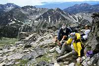
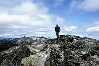
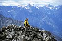 Summit of Switchback
Furthermore, Switchback Peak can be combined with Cheops and Martin Peak for one of the great alpine traverses in all of the Washington Cascades. Views extend all the way from Lake Chelan in the West, to the highest Peaks of the Lake Chelan-Sawtooth Wilderness area in the North. With great camping located at a number of nearby alpine lakes and meadows, this area calls out for exploration and a multi-day trip.
Getting There: From the North
 Cooney Lake from Traverse
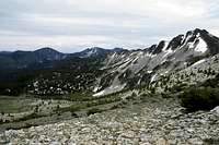 Traverse to Switchback
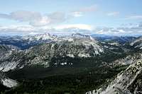 View North from Summit
 TOPO! Software Image
Take Crater Lake trail 1/2 mile, then taking the Eagle Lake Trail another 7 miles to Horsehead Pass. Drop 700 feet to Boiling Lake (6,900 feet). From Boiling Lake, take a way trail due South toward an obvious unnamed pass (7,400 feet), then drop a couple of hundred feet into the basin, still heading south on parkland for about 1/4 mile. Climb due east anywhere up to the ridge connecting Cheops on the left, and Martin on the right (easy, Class 1). Run the ridge due South towards Martin Peak. Stay on top of the ridge, but when forced off the top, veer to the right (west) side of the ridge. You can easily climb over the summit of Martin Peak (Class 2 with short sections of Class 3). To avoid the summit would actually make the climbing more technically difficult. From the Martin Peak summit, it is an easy 1 mile traverse over a broad open ridge (Class 1 and 2) to the summit of Switchback Peak.
Alternatively, one can bypass this ridge entirely by traversing through green parkland and meadows all the way from where you drop from the unnamed pass. Just hike south parallel to the ridge over easy terrain to the Northwest Ridge of Switchback Mountain for an easy (Class 2) ascent.
A great alpine traverse, easily done in one day from Boiling Lake, would be a Cheops to Martin Peak to Switchback Mountain high alpine traverse. All three peaks top out over 8,200 feet.
Getting There: From the South
Follow the Crater Lake Trail to the Eagle Lake Trail as described above, taking the cutoff at 2.5 miles (elevation 5700 feet) south away from Eagle Lake and head towards Martin and Cooney Lakes. Follow the trail 4.0 miles to Martin Lakes (elevation 6700 feet), and another 2.2 to Cooney Lake (elevation 7200 feet). Good camps abound at each location. Follow the trail above Cooney Lake for another mile until intersecting the easy Southeast Ridge of Switchback Peak. Climb easily to the summit. Class 1 and 2.Red Tape
 Summit View North
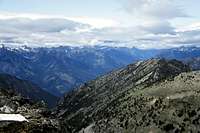 Summit View Southwest
A Northwest Trail Park Pass ($5/daily, $30/annually) is required to park at the trailhead.
Camping
Great camping spots abound at Boiling Lake, just over Horsehead Pass. Other good camping spots can be found in the meadows west of Cheops and Martin Peak, as well as in the meadows north of Boiling Lake under the slopes leading to Mount Bigelow. From the approach in the South, good camps are available at Cooney Lake.Contacts
You can get the latest information on road closures and trail conditions at the U.S Forest Service office.U.S. Forest Service
Methow Valley Ranger District
502 Glover
Twisp, WA 98856
(509) 997-2131