Introduction
![Ruta de los Volcanes]() Ruta de los Volcanes Ruta de los Volcanes |
, the north-westernmost island of the
Canary Islands, is one of the most beautiful and impressive islands on this planet. It is one of the youngest members of the Canaries family and like its siblings has been created by volcanic activity. Though rather small,
La Palma is the second highest island of the archipelago and boasts three mountain ranges on its small surface. The northern part of the island is taken by
Caldera de Taburiente, one of the world’s largest erosion craters, a giant cauldron of 9km diameter and almost 2500m height. The southern part of the island is formed by the
Cumbre Vieja, one of the youngest volcanic mountain ranges of the
Canary Islands, which also is almost 2000m high. Along the ridgeline of this range there is a beautiful hiking trail, the
Ruta de los Volcanes.
![Crater del Duraznero]() Crater del Duraznero
Crater del Duraznero
The route has a length of some 25km running between the very southern tip of the island at
Faro de Fuencaliente and
Refugio del Pilar in the north, which is located at the connection between
Cumbre Vieja and the neighbouring
Cumbre Nueva Range. Usually the hike is started at the refugio and ended in the village of
Fuencaliente (Los Canarios) while the southernmost part is skipped. It can be hiked in one day, an overall distance of 19km with about 1000m of ascent and 1700m of descent.
![Cumbre Vieja]() The top of Cumbre Vieja seen from Deseada I
The top of Cumbre Vieja seen from Deseada I
During our two vacations to
La Palma aech time we split the Ruta into three parts, mainly due to the weather. Often clouds start covering the mountaintops around noon after which the Ruta quickly gets less dramatic and interesting. Also, very often, the clouds are accompanied by fierce winds which sometimes blow at hurricane force. A good reason to retreat to the leeward side of the range. Here’s a report of those three days in December 2009 with an extra half day on
Llano del Jable, the cinder plain to the north of the range.
Lava and Wine
We arrived late on the island during the evening hours of December 18th. On Frankfurt Airport one of the tires of our plane had to be changed and weather conditions on the Canaries pushed back the start time again and again. We arrived at our apartment around 8 p.m. just in time for the local stores to close. Any grocery shopping had to wait until the next morning so we realized we would have a late start to our first vacation day.
And that is exactly what happened. We got up early and breakfasted but then wasted most of the morning trying to locate a good supermarket. A near accident (the car skidded and turned on the road to
Puerto Naos, thanks to no profile on the tires) and two hours later we were back at the apartment, trying to figure out how to spend the rest of the day. I suggested
Volcan San Antonio and
Volcan Teneguia, the two southernmost volcanoes on
Ruta de los Volcanes and since we had started our 2005 vacation exactly the same way we easily agreed. In February 2005 we had had weird weather conditions with western winds and a lot of humidity. We had nearly been blown of the summit ridge of
Teneguia, which still ranges among our scariest mountaineering experiences though the mountain in question is barely more than 400m high. This time around we were hoping for better weather even though the 6 day forecast did not look promising.
A slow car ride (I didn’t want to repeat the skidding experiment) took us to
Fuencaliente and as we neared La Palma’s southernmost village we realized that almost all of the formerly beautiful pine trees, which surround the village, had burned down in a forest fire. A later Google research told me that in August 2009, just four months previously a fireworks display during a village fiesta in the neighbourhood had started the fire and blasted away almost all of the trees in the south. However, the Canarian Pine is a hardy tree and as long as the trunk remains standing it will recover. Already we could see a lot of green buds close to the trunks and locals would later tell us that within the next five years the forest would return to its former beauty.
Being late we directly drove to the parking lot near
Volcan San Antonio. You have to pay a €3.50 fee per person but it spares some hassle. Also, you can visit an exhibition about the latest volcanic eruption on the island, in which
Volcan Teneguia, one of today’s summits, was created. The exhibition can be found in a room, which has been carved out of the sides of
Volcan San Antonio. Most of it is underground, as it turns out, right underneath the path to the summit of the volcano. Since we had seen the exhibition before we directly headed to the top.
![Crater of Volcan San Antonio]() The crater of Volcan San Antonio with Cumbre Vieja behind
The crater of Volcan San Antonio with Cumbre Vieja behind
The spot is popular and I guess that everybody who paid €3.50 tries to makes the most of his money and hikes the rim route to the top. The crater rim is wide and for most of the way the trail rather resembles a wide dirt route. It circles the crater, which at 1km in diameter is one of the largest volcanic craters on the island. It last erupted in 1677 and when it did, cinder covered all of the southern part of the island. This cinder – called Lapilli locally – later gave rise to Fuencaliente’s wine industry. The Lapilli store humidity very well and thus form a perfect soil for the local grapevines in the dry conditions.
Today, you can tell the age of the crater by the smooth edges. It has a perfect curvature and is rather deep in comparison. Canarian Pines have settled in the inside, a true type of pioneer vegetation as you can tell everywhere on the island. As we reached the summit low clouds started to develop on the coast in the north-west and quite suddenly we found ourselves in dense fog. We also realized that wind conditions were more moderate than in 2005 which gave cause for hope for decent ascent conditions of
Teneguia. On the downside, we already met quite a number of fellow hikers up here – a solitary route seemed out of the question. We turned around and started to descend, when suddenly the first drops of rain materialized out of thin air.
Not taking the rain seriously, we headed back to the parking lot, then turned on
Ruta de los Volcanes, which steeply led down through the northern slopes of the volcano. It started to rain more heavily and we put on our rain equipment. Mine was at the bottom of the pack so that I had to take out everything and put it back in again. I took so long that the rain had already stopped before I was fully equipped. We descended a few hundred metres and then reversed the whole operation. A complete loss of time!
![Side crater]() Volcan San Antonio side crater
Volcan San Antonio side crater
In this place the Ruta follows a dirt road, which eventually circles
Volcan San Antonio and heads back to
Fuencaliente. Naturally the Ruta turns off from this circle road somewhere close to its southernmost spot, where a hiking path turns off for
Volcan Teneguia. But since the road is often used by local vintners (sometimes also tourists) in their cars, we decided to turn off and follow an alternate trail, slightly to the south of it. It turns off from the road near an old crater, which from the looks of it, dates back to the time of the eruption of Volcan San Antonio. Some brittle walls have been left standing, which you can climb to with a bit of exposure in between.
![Roque Teneguia]() Roque Teneguia
Roque Teneguia
The main path, however, leads to
Roque Teneguia, an old volcanic plug, made up from reddish basalt. Here you can find petroglyphs, stone drawings, done by the original habitants of the Canaries, the
Guanches. They were a stone age type people when the Spanish Conquistadores discovered the island and put up a big fight before surrendering.
La Palma and
Tenerife were the last islands to fall into Spanish hands. Thanks to the drawings, the rock has been fenced off – otherwise it would be an interesting climbing location – one of the few ones you can find on the island.
![West Canaries Lizard]() Gallotia galloti palmae
Gallotia galloti palmae
It turned out that
Roque Teneguia was the place where we lost our trail (there has to be one place in every outing) but a dozen metres of steep down climbing finally took us to the irrigation channel our guidebook had recommended to us. Here we were somewhat hidden from wind so that we decided to search for a spot to have lunch. The place was found the lunch unpacked, but suddenly we were invaded by lizards. The Western Canaries Lizard males and females look like members of different species with the males black with blue dots at the belly and the females brown with white stripes. They gave us plenty opportunity to observe the differences.
Every lunch has its end and we headed onwards. We left the irrigation channel and headed for the hiking path to
Volcan Teneguia. Unlike 2005, when we were alone on the summit, this time about 20 people could be seen in various places of the route. The wind would certainly not be in the hurricane class today.
Volcan Teneguia erupted in 1971 and is the latest addition to the Canaries’ list of volcanoes. It developed two craters, a northern one, which we were just about to traverse, and a much larger southern one, the main epicentre of the eruption. In between the volcano piled up forming two summits. The northern one is located directly between the two craters and is very rugged. It has steep faces which in some places hang over the craters underneath. The southern summit looks more like a volcano, cone shaped and made up from volcanic cinder. Both are connected by a short, wide ridge.
![Volcan San Antonio]() Volcan San Antonio above Volcan Teneguia's north summit
Volcan San Antonio above Volcan Teneguia's north summit
In 2005 this ridge appeared to be much narrower than in 2009. With hurricane force winds we had to crouch and sneak our way to the higher south summit, hoping the wind would overlook our presence. This time there were strong winds but it was barely conceivable why we had deemed this ridge so dangerous. Everybody was strolling along and taking a break on the summit. We admired the views but quickly left again. Instead of descending the south ridge, which we had intended, we turned back to the north summit by the path we had come. We headed back into the north crater, then east and finally entered the
Malpais de Teneguia.
![La Palma s southern tip]() Looking across the Malpais de Teneguia towards Punta de Fuencaliente
Looking across the Malpais de Teneguia towards Punta de Fuencaliente
Maplais means “bad land” and clearly that’s what it is. The volcano has covered everything with lava, big, chunky lava in the west, fine cinder in the east. In between, a huge lava flow leads to the sea. The
Ruta de los Volcanes follows the cinder plains in the east of the malpais. The area looks desert-like with sand dunes. Black ones. The Ruta is indicated by bigger lava rocks to each side which make sure that nobody can go wrong. It is also meant to keep us tourists from entering the big lava flow, which is outright dangerous to hike through. Often the rocks give way underneath and the sharp edged lava can lead to dangerous injuries.
![Ruta de los Volcanes]() Volcan San Antonio above the Ruta de los Volcanes
Volcan San Antonio above the Ruta de los Volcanes
Trooping along, we came to an area where small pioneer bushes added a bit of colour and finally descended towards the southern end of
La Palma,
Punta de Fuencaliente with its two lighthouses. In 1971, during Teneguia’s eruption, the lighthouses were miraculously saved from the lava flows and survived. Further south there is a small peninsula, which is taken by salines, which nowadays are only kept for tourist amusement. Here the
Ruta de los Volcanes ends.
We turned eastward and followed the lighthouse road for a few steps before leaving onto a dirt road, which led to the windmills at Llano Centeno. Before reaching them, however, we turned onto a steep train, which headed back northwards in the direction of
Fuencaliente. It runs between two old volcano cones
Montaña de Abraham and
Montaña de Lago. As we reached a plain above the two cones the vegetation turned from desert like brush to intensively used agricultural. We had just entered the
Teneguia Vineyards. Another cone,
Montaña del Mago, was passed to the east and finally we headed up a wide valley towards another volcanic plug. As we neared the summit, the neighbouring islands
Tenerife and
La Gomera made their appearance, hovering above La Palma’s south coast. On top we reached a road, which led us back towards the parking lot at
Volcan San Antonio. The sun was already starting to set and we quickly (as quickly as no-profiled tires would take us) headed back to our apartment.
The Lost Week
![Liquid Gold]() Afterglow of liquid gold
Afterglow of liquid gold
The next day the weather forecasts were proven right. During the night it started to rain and it didn’t stop until December 26th. A whole week lost. At least almost.
La Palma is so high that the clouds which have to surmount it have to get rid of their humidity. As we lived in the west of the island from whence the clouds came we had torrential amounts of rain. However, on the eastern side (or to be more specific: in the north-east) weather along the coast was notably better. We had some dry days there and sometimes even saw a glimpse of the sun. Yet, these were coastal rambles, not the kind we enjoy most. I even went as far as stepping into the sea! Imagine this! We were treated to a whole hour of rainbows along the north coast (without getting too wet ourselves) and after one particular horrible day witnessed a wonderful afterglow. On the 24th after 24 hours of torrential rain across the whole island tiny ditches turned into big torrents. To remain dry we were forced to wall climb along the bottom of one of the barrancos near
San Andres, which added a bit of spice to the otherwise lame hike we did.
During the week many mud- and rockslides occurred all over the island. One of the two tunnels through the
Cumbre Nueva had to be closed, just like the Caldera road, which leads to
Roque de los Muchachos.
Rio de Taburiente, which heads out of the Caldera as a 2m creek usually, came down in a big 30m front, washing away one of the main roads of
Puerto de Tazacorte, where it enters the sea. The sea around the whole island had turned brown from all the debris that had been washed into it. In the cities and villages we had rolling blackouts. The airport had to be closed for four days, during which the four hour travel to
La Palma turned into a three day nightmare.
We started to feel lucky after all. Obviously, we unwittingly had booked the adventure package.
Peakbagging and a Close Encounter
But on the 26th of December all this changed. We woke up to clear skies. A short inspection outside informed us that there were clouds – but they kept a good distance from the island’s coastline. Now the typical Canaries weather seemed to have arrived. Clear mornings, cloudy afternoons and gorgeous early evenings. It found us well prepared.
There was no question as to where we would go – the caldera certainly was still out of bounds so we had to go to the
Ruta de los Volcanes. We intended to hike it as far as we could decently get, then turn back and maybe explore a different track on the return. Before 8 a.m. we were on the road and headed for
Refugio del Pilar, the northern trailhead for the Ruta. Upon entering the forests underneath
Montaña Quemada we realized that a lot of branches had been broken off from the pine trees – we were driving on a pine needle carpet. Later in the day we would find more evidence of this. However, the drive on this underground – still with profile-less tires – was far from easy and we took our time to carefully drive to the Refugio. In the end, however, we still were the first ones to arrive.
From the Refugio the Ruta at first follows a path through a dense forest of old Canarian Pines. It winds up the north slopes of
Pico Birigoyo, the Cumbre Vieja's northernmost outpost. A first lookout offered us a great view of the
Caldera de Taburiente across
Aridane Valley – there were only a few clouds above
Cumbre Nueva. Everything else was clear.
![Caldera de Taburiente]() Caldera de Taburiente as seen during the ascent to Pico Birigoyo
Caldera de Taburiente as seen during the ascent to Pico Birigoyo
In 2005 we had climbed
Birigoyo in a whiteout. The route had not seemed to be too difficult but we really couldn’t tell. We had opted for the easier southern route, which we also intended to climb today. However, a sign we had missed in 2005, pointed to
Birigoyo and suddenly we found ourselves on the steep northern route. Having climbed cinder cones before, we realized what we were up against – but real hardmen and –women never turn around. And so we fought and scrambled our way to the top. We realized that Birigoyo’s crater, which we had missed in 2005, is rather big and that the both routes follow the different sides of its rim. Again a detail, which had escaped us in the whiteout.
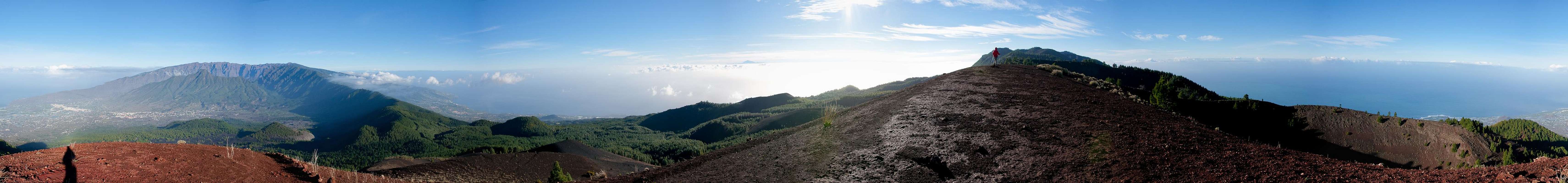
360° summit panorama Pico Birigoyo |
The guidebook told us: “lucky is he who stands on top of
Birigoyo on a cloudless day” and as we did just that right now, we utterly enjoyed ourselves. We would have, anyway, if the wind would have let us. It was blowing fiercely again and I - once again – went through the motions of unpacking everything to pick out the warm clothes from my backpack. But visually we certainly enjoyed ourselves. The Caldera and a cloud capped
Cumbre Nueva took centre stage but I enjoyed the view of
Teide on neighbouring
Tenerife the most. But by the time I had finished taking my 360° panorama, Judith had already started to leave and I had to hurry to catch up with her.
![Tenerife]() Pico del Teide on Tenerife as seen from Pico Birigoyo
Pico del Teide on Tenerife as seen from Pico Birigoyo is not part of the Ruta and neither are
Montaña de la Barqita and
Montaña de los Charcos, the next two summits on Cumbre Vieja’s ridge. The Ruta runs by to the west, steadily climbing until it reaches
Pico Nambroque, which it also passes to the west. To tell the truth, the Ruta only leads to one summit, the lower summit of
Volcan de la Deseada, the highest mountain of the range. Everything else is extra.
But we weren’t here to have fun (of course we were!) and so we decided to stay on the ridge and climb every mountain on it. This would lead to quite some elevation gain but we had time enough and could turn back at any time. So why not go for some peakbagging? We followed the southern rim of the
Birigoyo Crater until a path turned off south. Here we descended and found ourselves at the edge of the crater of
Montaña de la Barqita, which we followed to the top. There was not much new to see, so that we headed along and descended further south. During the descent we realized we were walking on a carpet of green needles – the days before the pines had shed all excess weight. That place won’t get as green anytime soon.
![Caldera de Taburiente above the summits of Cumbre Vieja]() Caldera de Taburiente above the summits of Cumbre Vieja
Caldera de Taburiente above the summits of Cumbre Vieja
Next stop was
Montaña de los Charcos, a twin peaked volcano with a big, old crater in the middle. Briefly we had to return to the Ruta, where we met the first fellow hikers. But since we turned off again, to climb the west face of the north summit we quickly were alone again. Still the wonderful Canarian Pines kept fascinating me. They have long (25cm / 10 inches) soft, light green needles, which they use to filter humidity out of the air on foggy days. Hiking in a pine forest on a cloudy day will get you wet – but we were still to gain that experience a few days later. Both summits offer good views towards
Santa Cruz de la Palma, the island’s capital as well as the Caldera in the north. The previous
Cumbre Vieja summits already line up beautifully. The southern summit is covered in trees. We bagged the summit and shot a glimpse to the next destination:
Pico Nambroque.
![Pico Nambroque]() Pico Nambroque
Pico Nambroque
Now,
Nambroque – or rather its crater
Hoyo Negro – is one of the latest additions to the
Cumbre Vieja. It erupted in 1949 together with two more volcanoes during which eruption the western side of the mountain range slipped by several metres. Thus it is one of the notorious ’49ers which are held responsible for the Megatsunami Hazard, which has been discussed in recent years.
![Crater del Hoyo Negro]() Crater del Hoyo Negro
Crater del Hoyo Negro
We returned to the Ruta and hiked up the cinder field which separates
Nambroque from
Montaña de los Charcos. A few good views of
Pico Birigoyo and
Pico Bejenado revealed themselves before we reached the giant crater of
Hoyo Negro. We had missed it in the whiteout of February 2005 though now it appeared impossible to miss. It is a giant black hole in the ground – the forces which created it must have been immense. The blackness makes it difficult to photograph and I wasted quite a number of shots. Now we turned to
Pico Nambroque which we had climbed previously but in a (different) whiteout. Time for another 360° panorama…
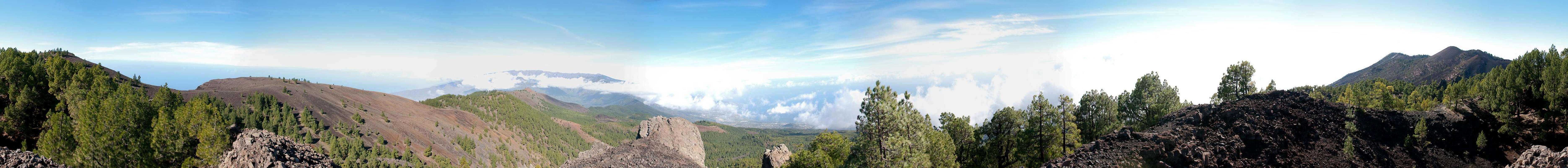
360° summit panorama Pico Nambroque |
We returned to the Ruta and traversed towards the next summit
Montaña del Fraile. This is another of the ‘49ers and rises out of a pool of black lava, the
Lavas la Malforada. In its blackness it is a magnificent sight and I kept taking pictures as we approached. In order to get to the summit we had to leave the Ruta again.
We circled the crater of the mountain,
Duraznero, one of the most colourful spots on
Cumbre Vieja. The crater is red and brown and an occasional pine tree pioneering vegetation in the crater throws in a wonderful contrast. Also, sulphurous smells were in the air. We turned the crater and headed for the next summit –
Volcan de la Deseada.
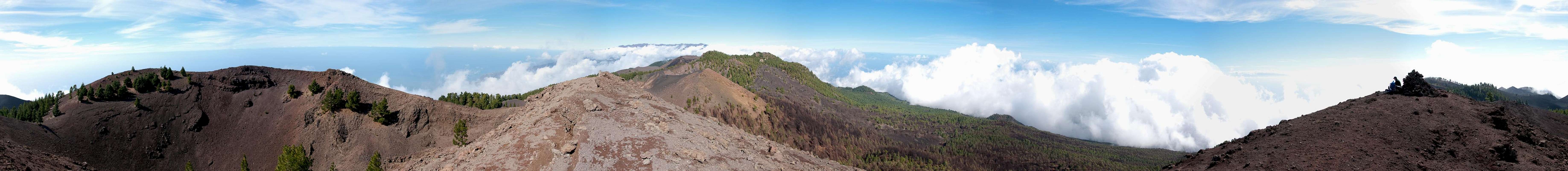
360° summit panorama Volcan de la Deseada |
is a twin summitted volcano with
Deseada I at 1946m and
Deseada II at 1931m separated by a long stretched crater. It is the highest mountain of the
Cumbre Vieja Range, coloured brightly red. We headed to
Deseada I where winds were raging again. Hiding behind the summit cairn we took out our lunch. All around clouds started to close in on the summits and we asked ourselves how far we would hike today. I suggested
Montaña Negra a little further on, but shortly thereafter it disappeared in the clouds. Also, it was getting cold and uncomfortable up where we were so that we decided to hike down to the southern mouth of the crater and head back across
Deseada II.
![Crater of Volcan de la Deseada]() Crater of Volcan de la Deseada
Crater of Volcan de la Deseada
We followed through with the plan but had a short break during the ascent of
Deseada II. It turned out that we had to put on more clothes to withstand the cold winds and I went through the now familiar packing-and-unpacking routine again. One more picture of
Deseada I (which now ranks among my favourites of the vacation) and we headed on. We soon noticed how busy the Ruta had become. People were popping up from everywhere. On the summit we met a guy who was waiting for his kid to come up.
A kid in the midst of the Ruta de los Volcanes! Impressive! Judith joked that there must have been a bribe of a big amount of sweets involved … Only two weeks later I found out from
this picture that we had met SP members
Scott and
Kessler and a perfect opportunity to get to know each other after 6 years of SP membership had been wasted.
We waited for
Kessler to pass (I took the opportunity to shoot the panorama above) and headed back towards
Montaña del Fraile. This time we took the western branch of the trail around
Crater del Duraznero, which turned out to be even more colourful than the eastern branch before. Again we passed the
Lavas de Malforada but instead of climbing
Pico Nambroque again I scrambled up to the highest point of the
Hoyo Negro Crater. Again, my pictures were seriously overexposed due to the blackness of the crater and again I didn’t realize.
![Crater del Hoyo Negro]() Crater del Hoyo Negro
Crater del Hoyo Negro
Here we left the Ruta and headed down the eastern side of the Cumbre, right underneath the north face of
Pico Nambroque. Immediately the wind, which had been bugging us, slowed down. I had the chance of another favourite shot with
Teide on
Tenerife looking right at me through a window of clouds. We then dived into the forest and only resurfaced at
Llano la Mosca. Here we switched to a dirt road, which took us all the way back to
Refugio del Pilar. At home again, we were treated to another wonderful afterglow.
![December 26th sunset]() December 26th sunset
December 26th sunsetColours Red and Black
Again a day went by, which we spent elsewhere – this time a wonderfully panoramic hike along the upper
Cumbre Nueva from
Reventon Pass to
Punta de los Roques on the rim of
Caldera de Taburiente. The next day, December 28th, we planned to drive to
Roque de los Muchachos but found the road closed due to rockslides. Instead we turned and headed south to
Fuencaliente to tackle the central part of
Ruta de los Volcanes. Though weather was fine everywhere the village itself was dozing underneath low hanging clouds. Still we started the hike, counting on better weather higher up.
![The village of Fuencaliente]() Fuencaliente
Fuencaliente is a colourful village but as we started to head above its northern outskirts we realized we were walking through the devastation zone of the recent (August 2009) forest fires. Moreover, we soon entered the fog which gave the surroundings a particularly gloomy atmosphere. None of the trees appeared to be unharmed but all were still standing. However, as we looked closer, all of the burnt trunks were sprouting new needles – there was not a single tree, which did not have some life left within. On the downside we had to realize that the vegetation cover was missing completely so that recent rains had taken a heavy toll on the ground underneath. Deep ruts had developed, laying bare the roots of the neighbouring trees. As we got higher we realized the whole extent of the fire – from 700m through 1200m of elevation we didn’t see much more than burnt wood.
![Canarian Pine]() Fog and burnt wood
Fog and burnt wood
We crossed a few dirt roads, then passed the radio tower on
Montaña de la Pina. Finally we reached the south slopes of
Montaña la Semilla. In 2005 we had climbed it with nice views of
Volcan Martin ahead but today it was still within the clouds. Soon, however the sky cleared as we reached the plain to the south-west of
Montaña Pelada. Finally, the pines turned green and we started the steep ascent to
Volcan Martin. The Ruta winds its way up the west slopes of
Montaña Pelada, before turning into the saddle, which separates the mountain from
Volcan Martin. Then an even steeper section takes you through black cinder slopes to the east of the volcano, a wonderful black volcanic landscape with
Montaña Cabrera’s lower summit,
Hoya de la Manteca, to the west. We headed towards the north of
Volcan Martin, to attempt the summit along the north ridge of the higher western summit.
For Judith this attempt ended after a few hundred steps. We realized that – once again – we had entered an area of hurricane strength winds. She was pushed around and almost lifted off her feet and blown into the crater. Before that happened she decided to turn back while I pushed on. I relied on my heavier weight with the addition of a well filled back pack.
![Crater of Volcan Martin]() The crater of Volcan Martin
The crater of Volcan Martin
However, after another few hundred steps I received several severe blows, which also pushed me into the direction of the crater. I cowered and let the gusts pass, then sprinted towards the summit block to hide behind it. There I had stunning views of the surrounding Canary islands
Tenerife,
La Gomera and
El Hierro, all hovering above the southern tip of our island.
![Tenerife]() Tenerife
Tenerife
I returned along towards where Judith was waiting and we decided to have our lunch break here. Though we had found a place outside the worst gusts of wind it was very uncomfortable as we had to sit on sharp edged lava blocks. I wolfed down my food and then set out to explore a bit more of the Volcano. I looked into and through the crater and found one of the most colourful places I have ever seen in nature: the northern mouth of
Volcan Martin’s crater was such a bright red, which contrasted beautifully with the dark sky overhead. Add a bright green Canarian Pine and you get this:
![Volcanic Colours]() Volcanic colours
Volcanic colours
However, we packed again and returned to the Ruta, which now climbed the east slopes of
Caldera del Bucaro. We passed it in a wide sweeping curve and headed up a wide valley towards
Volcan Cabrito, which we passed to the west. Finally we reached 1800m and the views opened up to reveal the south slopes of
Volcan de la Deseada. Since we had already been there two days ago, Judith voted for turning and retracing our steps while I suggested to head a few steps to the west to
Montaña Negra. Reluctantly Judith agreed and we descended towards it.
![Volcan de la Deseada]() Volcan de la Deseada
Volcan de la Deseada
Soon we found ourselves in a completely black landscape. We climbed to the summit and admired the moonscape panorama. To the west another big crater stretched underneath us while the rest of the area was covered in black Lapilli. Towards the north a small window remained open towards the pine covered
Deseada, behind which the western part of
Caldera de Taburiente hovered. However, Judith explained that time would be running short, turned around and stomped away. I had barely time enough to complete my panorama shots and hurried after her.
360° summit panorama Montaña Negra |
As usual at that time of the day (around 1 p.m.) the first clouds started to roll in.
Deseada soon was covered and as we headed back they piled up underneath us. We now were going at a good pace as the wind pushed us and temperatures started to drop quickly. One quick photo of
Volcan Martin and we rushed by. The oddity of a blue lake between burnt trees stopped me for a few seconds but Judith quickly gained on me and I had to follow.
Between
Volcan Martin and
Montaña Pelada we started to search for a resting place out of the wind to have a little snack but that resting place only materialized much later at a much worse position. After which we entered the kingdoms of clouds, which did not release us before we returned to
Fuencaliente. In fact, in the village the fog was worst and we had to drive for quite a while until we were able to distinguish anything again.
A Few Last Moments
Now the vacation was turning to an end and we struggled making the most of it. Once we were back on the north coast (yes you can blame the weather), then we had a wonderful day on the Caldera Rim. The day before we had to leave we hiked into the Caldera but clouds and high water in
Rio de Taburiente prevented us from getting to the most interesting sites. Then January 1st arrived (we slept through the New Year Celebrations), we packed and got ourselves ready. But since our plane wouldn’t take off before 4:30 p.m. we still had a few hours left and I suggested
Llano del Jable.
![Montaña Enrique (1255m) and Caldera de Taburiente]() Montaña Enrique and Caldera de Taburiente
Montaña Enrique and Caldera de Taburiente
The llano is a volcanic plain, which was created during one of the longest lasting eruptions on
La Palma, which took place between 1470 and 1492, the first historical eruption documented. During that time
Montaña Quemada was piled up, together with
Montaña Henrique the northernmost outpost of the
Cumbre Vieja Range. Huge amounts of cinder were emitted during the time and created a black plain:
Llano del Jable. In the north-east of the plain a giant lava flow led toward the centre of the
Aridane Valley and can still be seen, especially from the outlooks of
Cumbre Nueva.
![Llano del Jable]() Llano del Jable
Llano del Jable
You have to pass the llano, when you want to reach
Refugio el Pilar and thus we had been there several times. We had hiked across the plain but had never attempted
Montaña Quemada, which I now put on the menu. The climb was short, a mere 200m elevation gain but it proved to be very steep and even challenging. And yes – you walk on cinder – two steps down for every three steps up. Though the summit of the old volcano is covered with pines we did have wonderful views of the caldera and the llano.
Pico Birigoyo appeared through some mist. To kill more time we returned to the plain and crossed the llano and found us a place for lunch. Upon returning we realized we still had two hours to kill so that we drove to
Montaña Breña in the east of the island. It wasn’t worth the effort but we were successful in killing time. We barely had enough time to pick up our baggage, drive to the airport, return the rental car and check in in time. We made it however, and a smooth flight took us back to Frankfurt Airport were our own German winter immediately grabbed a hold of us. Snow was falling at subzero temperatures and on our drive back home I succeeded in making our taxi driver envious with stories of our warm (but wet) winter vacation. And tales of a route running along between dozens of volcanoes ...


Comments
Post a Comment