
|
|
Trip Report |
|---|---|
|
|
28.70000°N / 17.8°W |
|
|
Oct 1, 2008 |
|
|
Hiking |
|
|
Fall |
Camping wild
I’m sound asleep in my tent, after a long and satisfying day of hiking. Something wakes me up. It’s my tent, shaking violently in the wind.I remember the park ranger I had met, just a few hours before. He looked me over and asked about my intentions, and I said that I was hiking the long distance route. He looked worried and said that the weather forecast wasn’t too good. He told me about a cave in which I could shelter for the night.
Although I carried a pack, I guess he assumed I planned to sleep under the stars, but I had a small tent inside. Still, I listened to his explanation, thinking that perhaps that cave might be more comfortable than my tent, so I would check it out. It never came to be, because I couldn’t find it. No big surprise, in retrospect, because his English wasn’t very good and my Spanish is poor.

Quiet before the storm
These thoughts are going to my mind now. Belatedly, I realize why he looked worried. This isn’t just a bit of bad weather, this is a real storm, and I’m camping on a summit on the rim of a crater! The worst part of the storm is the wind. It’s raining too, but that doesn’t worry me. I know my tent can handle quite a downpour. And most importantly, it’s not an electrical storm.
I'm lying in my sleeping bag, trying to get to sleep again, but I can’t. Is my tent strong enough to withstand the wind? And did I secure it well enough? Imagine, if it gets real bad, I might even end up being blown down into the crater, tent and all! Not that I consider that a real possibility, but if the wind would get even stronger ...
After procrastinating for an hour or so, I go outside. My reward is getting wet quickly. Still, it has to be done, so I check my tent pegs, tighten my guy-ropes, and attach all my spares.
Back inside, I relax. When I was outside, the storm didn't feel quite as strong. The flapping must make it seem worse. It’s dry in here, I’m sheltered. Nothing more to do now, so I stop worrying.
As I wake up the next morning, it’s very quiet. The storm has passed and my tent isn’t shredded. Even better, it’s still completely dry inside. As I peek outside, I cannot see far. A thick mist covers everything, muffling any sounds in the process. Too bad, no views. Ah well, I’ll just sleep in today.
The beginning
After I decided to go to Tenerife, to hike and climb Teide, I started looking for other interesting hiking opportunities in the neighborhood and found the GR 131 El Bastón (The Walking-Stick), on La Palma. This long distance route incorporates two popular hikes, the Ruta de la Cresteria and the Ruta de Los Volcanes.The trail goes from coast to coast, connecting Puerto Tazacorte on the west coast to the southernmost tip of La Palma. The total distance is about 70 km (this is my own estimate afterwards; I found wildly diverging numbers beforehand, mostly much larger). What makes it stand out is its total combined ascent of over 4000 m. A sizable part of the route lies around 2000 m altitude, which, I thought, would be good preparation for Teide the week after, and from what I had read about it, the views promised to be very good.
Drenched in Los Tilos

Los Tilos in the morning
In the Caldera de la Taburiente

Looking into the crater along the Barranco de las Angustias
Mirador de los Brecitos
The centerpiece of La Palma is the enormous Caldera de la Taburiente, a truly magnificent 8 km wide erosion crater. There are many hiking trails in and around it. Also, there is a campground in the crater itself, and that was my goal for the day. After cutting some red tape (I’ll get to that later), I hiked in from Los Llanos de Aridane taking the high trail by the Mirador de los Brecitos.
 |  |  |  |
Deep inside the crater
Early next morning, I hiked in the crater. It gave me a prehistoric feeling, even if La Palma is just a few million years old. Where are the dinosaurs?


 |  |  |  |  |  |
Barranco de Las Angustias
I hiked out again through the Barranco de las Angustias, which contains the only river flowing out of the crater. Needless to say, if it’s raining hard, this path is out of commission, but since my experience at Los Tilos, the weather had improved.
 |  |  |  |  |
Puerto Tazacorte
At the end of the trail, I decided to follow the river all the way down to the coast at Puerto Tazacorte, right at the start of El Bastón. Sometimes there was road or a trail next to the river. Where there wasn’t, I just hiked along – or in – the mostly dry river bed. And, by the way, I also had to climb a fence once.
In Puerto Tazacorte, I bought a bit more food for the next couple of days before looking for a place to stay. Being a tourist town, it had loads of hotels, and it was the quiet season, but all I could find were hotels offering apartments for a week. That’s no good; I just need a bed for the night! I want to leave tomorrow morning, even before dawn! Ah well, that’s what happens sometimes if you don’t plan everything ahead. You’ve got to adapt.
Jumping the gun
Anyway, I was feeling good and it wasn’t even four in the afternoon, why not start walking right away? On the map, I could see that the route would cross a major road at Mirador del Time, at about 500 m altitude. Maybe the bar up there has beds. If not, I can catch a bus or hitch a ride to Los Llanos de Aridane, and surely there I will find a place to stay. And so I started the trek, one day earlier than I thought I would.The start was very promising. Next to the beach, a big cliff rises straight out of the ocean. As you get closer, you can see that a path has been constructed that winds its way up the cliff. Once at the top though, the secondary roads to the main road are best forgotten. The great views only return at the Mirador del Time.
The bar was open and I went in. Unfortunately, it was just that, a bar. No beds. Not much food either, but I had plenty of that in my pack, including what I needlessly bought at Tazacorte, as if my pack hadn’t been heavy enough. As it turned out, I had plenty of time before the next bus would arrive, so I walked to the neighboring hamlet of La Punta and had a nice dinner before I hopped on the bus to Los Llanos de Aridane, where I found a bed in a local hostel.
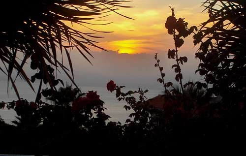
Sunset over the Atlantic, from La Punta
The High Point

Close to the rim

Clinging on for dear life
Alpine start
I knew it was going to be a very long day.
The plan called for over 2000 m of elevation gain. In fact, without the jump start yesterday, it would have been even more! I had never done that much with a full pack, so, well before dawn, I was on the first bus back to Mirador del Time.
Guided by headlight, I started walking uphill, first on a road, later a trail. I walked slowly, because it was going to be a long day. The few spatters of rain didn’t bother me. I passed some locals, who thought I was crazy.
The first few hours, up to the Torre del Time (1260 m), were not all that interesting, but from there upwards, the scenery improved. After a short rest, I continued, still going slow.
Pines
A tranquil pine forest now covered the slopes and the crater rim, blocking any views most of the time. The needles on the trail muffled my steps. Occasionally, where the trail got close to the rim, I had a peek – if only the clouds had cooperated, I might actually have seen something of the crater. Still, occasionally I caught a glimpse.
 The pine forest above Torre del Time The pine forest above Torre del Time |  Clouds rising from the crater Clouds rising from the crater |  I saw no better camp site than this - soft, but not quite flat and no water I saw no better camp site than this - soft, but not quite flat and no water |

Above the pines on the western rim
In the forest, there were few orientation points. I thought I was still going slow, but couldn’t check my position against anything on the map, until I reached the open area above the pines. It was much earlier than I had expected. Despite trying to go slow, I had made good time; I was well over 2000 m already! Soon after, the path got near the rim again and now, finally, I could see inside the crater, while some clouds were rising out of it.
Sunshine
The trail leveled off now, and made a slow turn to the east. Above the clouds now, it was sunny and warm. Shards of mist came drifting up out of the crater. I was very relaxed and had long lunch break, basking in the sun and enjoying the scenery.
 |  |  |  |  |
 |  |  |  |  |

Fog shrouding Roque de los Muchachos
Roque de los Muchachos
Approaching the highest point, Roque de los Muchachos (2426 m), the clouds moved in again.
Never mind, I was on a high, because I had done the hard part with time to spare. As I had heard, there was a tap, so I filled up my water bottles. And it was at that point that I met the park ranger.

Yep, this is it!

Looking back at Puerto Tazacorte, where it all began
Pico de la Cruz
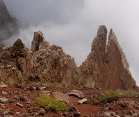
After the chat and a short walk around the rocks – climbing them is not allowed – I leisurely continued on the trail, knowing that I had plenty of time. The trail went gently up and down now, never steep, but no flat place in sight anywhere. And no cave either. Eventually, I got to Pico de la Cruz, where there were a few spots big enough to put up a tent, just as I had read about in other people’s reports.
Officially, camping wild is prohibited, but the nearest accommodation option is the refuge at Punta de los Roques, 14 km further along the trail. Luckily, there is always the internet, and so I found out about Pico de la Cruz. There were a few flat spaces, out of sight of Roque de los Muchachos and the astronomical observatories. Besides, the ranger appeared much more concerned for my safety than for enforcing camping rules, so perhaps camping wild is tolerated for long distance hikers, as long as you don't make a fuss about it - and leave no trace of course.
Sleeping in
The next day, with the storm gone but the world in clouds, hiking the crater rim seemed pointless. I would rather see something, so I decided to wait a while, or even until tomorrow, if necessary. Fortunately, around midday, the weather improved. I was packing up inside when I heard noises outside. It was a guided tour group! They were very surprised to find a tent up there. I had a short friendly chat with their guide, and they were on their way. |  |  |  |

Pico del Escuchadero
Soon, I had finished packing and followed suit, and I caught up with them near Pico de la Nieve. Having everything organized for you is indeed a convenient way to hike the crater rim. I’ve been on organized hiking tours in the past, and having all the logistics taken care of saves a lot of time and hassle. Over time, I've come to value the flexibility that comes with being independent, but I expect to keep going on organized trips occasionally too.

Pico del Escuchadero
As I chatted with the guide and some of the group members, I learned that another guide would take part of the group up Pico del Teide next week. As we compared plans, that happened to be on the same day as I planned to be there. And, sure enough, I did indeed meet him the week after. What a coincidence!

Small side trail ín the east rim
South of Pico de la Nieve the trail got real quiet. There were no roads near the rim anymore, so this is really hiking territory, but still beautiful. I got some good shots of Pico del Escuchadero, before the clouds started to come back again.
I ended the day in the Refugio de la Punta de Los Roques. Didn’t climb the Roques themselves though, my mind was set on eating and sleeping. The refuge was messy. I cleaned it up a bit, ate and went to sleep.
More Rain

I'm on track
By the way, notwithstanding its name, it’s not a refuge, but a public camp ground and barbecue area. The barbecues are big, and have a roof, so that wasn’t too bad after the rain.
Ruta de los Volcanes
The last stage of the route is spectacular, according to what I had read about it, and seen in the exhibition at the visitor center at Refugio del Pilar. Of course, you need clear views for that, and I had no such luck. It was almost dry, foggy and cold. Higher up, the wind picked up as well and some other hikers, who had started at Pilar, called it a day. Apart from not seeing much, the weather didn't bother me. Unfortunately my plane back to Tenerife wouldn’t wait, so I couldn’t stay at Pilar and hope for better times. I’ll have to go back there someday, to check out what I’ve missed.Around Fuencaliente, approaching the end of the trail, the weather improved markedly, but it was too late now to go back for the views. I had to contend myself with the views at the end of the line.
 The last hurdle The last hurdle |  I realize I could eat something ... I realize I could eat something ... |  End of the line - I'll pass on descending the final meter End of the line - I'll pass on descending the final meter |
I'll be back!
Epilogue
Back in the Netherlands, a friend with a strong interest in everything related to weather phenomena found out that there was a weather station on top of La Palma. The storm had 'only' been a force 8.Weather patterns on La Palma
As I found out, La Palma is a beautiful island, but it gets a lot more rain than Tenerife. I knew that before I went, but nothing like a good soaking to hammer the message home.
There is a whole lot of Atlantic ocean west and north of La Palma. If the prevailing winds bring moist air, the clouds hit upon the slopes of the Caldera, rising well above 2000 m. As a result, this part of the island is very lush.
The south lies in the rain shadow of the mountains and consequently receives much less rain.

Clouds trying to get over the eastern rim
The Caldera is a separate story altogether. The crater rim has its own weather, like the miniature mountain range that it is. In winter, there can be snow – Pico de la Nieve is even named after it!
The inside of the crater is well protected from high winds and doesn’t get as much rain as the northern part, because the clouds have to get over the rim first and are likely to drop their load before that happens. However, if it does rain, the rivers, especially in the Barranco de las Angustias, can flood and become dangerous.
Red tape
If you’re going to La Palma, do check up on this. Things may have changed since, or I might be misinformed. As I said, my Spanish isn’t that good, and unlike on Tenerife, the officials on La Palma spoke poor English.
External Links
Parque Nacional de la Caldera de TaburienteHiking trails on La Palma

Comments
Post a Comment