
Comments
No comments posted yet.
|
|
Trip Report |
|---|---|
|
|
28.65293°N / 17.82497°W |
|
|
Mar 1, 2023 |
|
|
Hiking, Mountaineering |
|
|
Winter |
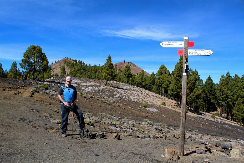
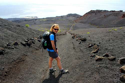
The “Route of the Volcanoes” on the island of La Palma in the Canary Islands, lies along the crest of the Cumbre Vieja in the southern part of the island.
The route begins at the Refugio EL Pilar, located at a road pass crossing the mountains in between the Cumbre Nueva to the north of the pass and the Cumbre Vieja to the south. The route roughly follows the ridge of the Cumbre Vieja southwards passing over and in between the many volcano summits located along the way. It descends to the town of Los Canarios, then continues southwards again over more landscapes of volcanic activity before ending at the southern tip of the island at the Faro de Fuencaliente – the lighthouse at Fuencaliente.
The total route is approximately 23 km long (15 miles) and has ascent of around 700m (2300ft) and descent of around 2000m (6500 ft). I give these figures as a generalisation as it’s possible to do different versions of the route and take in different peaks along the way. Because of the length of the route and the height difference, the route is usually done in several stages often over different days.
Another factor that can’t be underestimated is the volatile weather conditions that may be encountered over the route.
When Gangolf Haub wrote on SP that “Weather is always an issue on La Palma.” I read it and thought “Ok, that would be true in any mountain region.” However, I underestimated how unpredictable the weather here can be. Weather forecasts cannot be trusted – no matter where they come from.
More often than not, the hills are covered in thick clouds by 11.30 am. This may make it wet and cold on the ridges. It could be calm and clear (above the clouds) on the Cumbre Vieja while Fuencaliente might be experiencing heavy rain. There could be gale force winds on the Cumbre while it may be calm in Fuencaliente.
Before we visited the island, I had no idea that this route would occupy so much of our time there or what a contrast – particularly in the weather – we would experience while enjoying our days out. In the end, we spent 5 different days doing different parts or different versions of the route. I will try to put them all together.
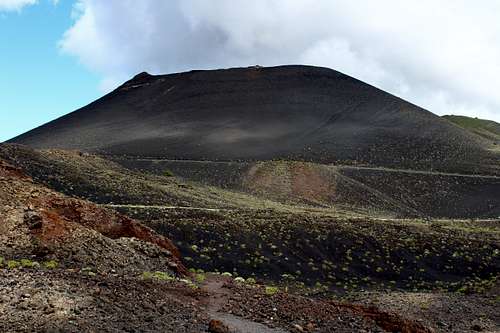
We had only been on La Palma for a few days when we decided to follow the good weather southwards to the town of Los Canarios and explore the route from the town down towards the lighthouse at Fuencaliente, taking in Volcan San Antonio and Volcan Tenguia along the way.
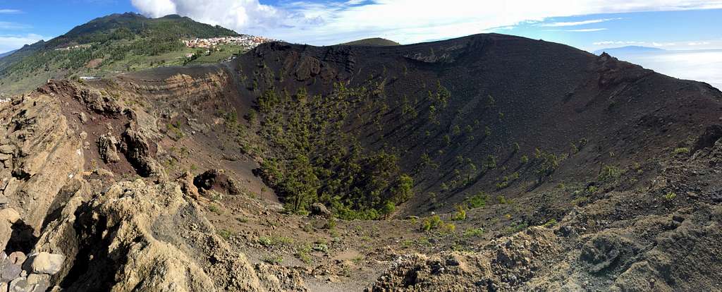
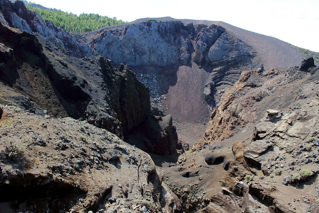
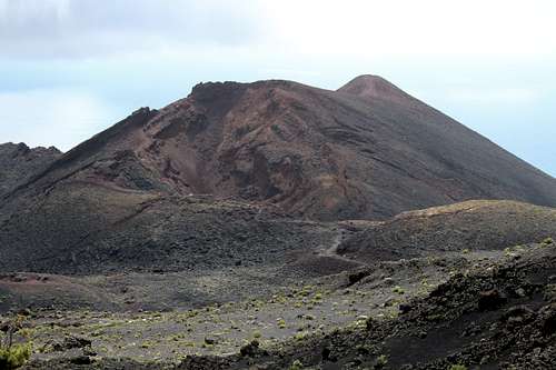
Leaving the bus, we followed roads downhill as this seemed the thing to do and we didn’t see any signs directing us. The visitor centre at the Volcan San Antonio was open but quiet so we paid our 5 Euros and went in. It’s well worth the visit as it has a great display explaining everything you might want to know about volcanos both in general and in the region. San Antonio and Teneguia are the local volcanoes but not surprisingly, the 2021 volcanic eruption on La Palma – now named as Tajogaite – has a display area to itself with a good film of the event.
We ventured outside to follow the path around the rim of the caldera of Volcan San Antonio. The volcano erupted in 1677 and we had great views into the now tree-lined caldera and also south across the lava flows to Volcan Teneguia. On that day, it was possible to look across the sea to the nearby islands of Tenerife, La Gomera and El Hierro. One disappointing thing was that the actual highest point of the rim of the volcano is off limits to the public – this became a bit of a recurring theme!
The extent of the original lava flow was huge but this has then been compounded by the eruption of Volcan Teneguia in 1971. The lava from this volcano covered some of the original flow and created new land along the southern coastline.
We returned to the visitor centre and set off down the long-distance path GR131, towards Volcan Teneguia, aiming to climb it. The route was quite crowded as it was the weekend but I couldn’t really see anyone on Teneguia.
After a spot of lunch sitting on a manmade “levada” with plenty of lizards for company, we continued. It soon became clear why I couldn’t see anyone on Volcan Teneguia, the route had been closed before the steep ascent started.
“Conservation reasons” was the rather vague excuse for the closure and there was no indication that this was a temporary measure. It was all the more unusual as there are several 4wd tracks across the landscape to the farmed terraces where the grapes are grown to produce the local wine.
|
|
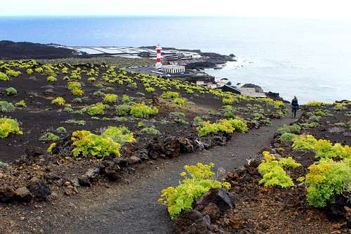
We headed east and decided not to descend to the lighthouse. Instead, we ascended a poorly marked footpath shown on our map through the vineyards towards the Pico de Tablas. It was hot going in the afternoon sunshine as we climbed back up to the town. We frequently saw Canarian Kestrels hunting probably for the lizards who live under the bushes and in between the rocks. We finished on what is now a cycle track back to Los Canarios. We were just in time to get the afternoon bus back north.
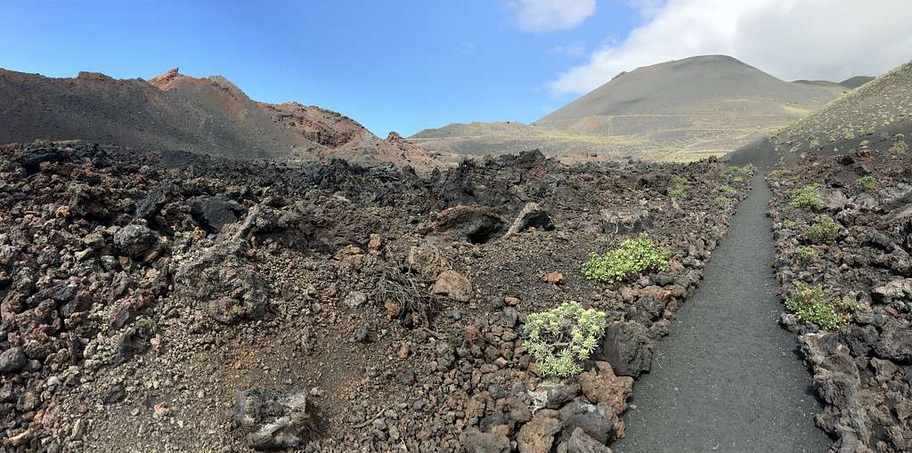
We returned 3 days later, again following the only good weather on the island. We descended and picked up the GR 131 southwards where we left it near Volcan Teneguia. We descended further to cross the lava field from Volcan Teneguia towards the sea.
We were glad we had returned. The landscape here was like nothing we had seen at that point. From the 1971 eruption, the rock had been melted, fused and contorted into unearthly shapes.
“It’s easy to see why they believed that they were looking into hell when a volcano erupted!” Marie said at the time.
|
|
A reasonable manmade path has been created through the lunar landscape and the odd hardy bush or plant has started to reclaim some space. However, there is an unescapable feeling of desolation over the land.
Walking downhill was pretty straightforward and we didn’t envy those who had decided to walk back up to the town.
As we got closer to the sea, the plant life increased – presumably due to an increase in moisture?
We reached the lighthouse, a survivor from the lava during the 1971 eruption and took the option of the bus back to Los Canarios.
This is a spectacular area for those of us not used to living in the shadow of recently active volcanoes. The landscape is extremely rugged and unusual but it has been tamed to a certain extent to facilitate the tourist and wine producing industries. This is a bit of a shame but maybe without this taming, we might not be allowed to visit at all?
We were up at the refugio by 9.00 am thanks to a local taxi but the weather wasn’t as promising as had been forecast. We had already spent a day struggling up a very steep path to the Cumbre Nueva, only to find it engulfed in cloud. We didn’t want to repeat that.
We had been waiting for a good weather forecast for this route and had been lured upwards by the promise of clear skies. I had expected the car park to be crowded but there was only one car with a German couple getting ready to go.
We passed the silent refugio and followed signs for the GR 131 footpath. There are several versions of this route and we had decided to follow the one proscribed by our guidebook which meant staying on the GR 131 and traversing around several summits rather than over them.
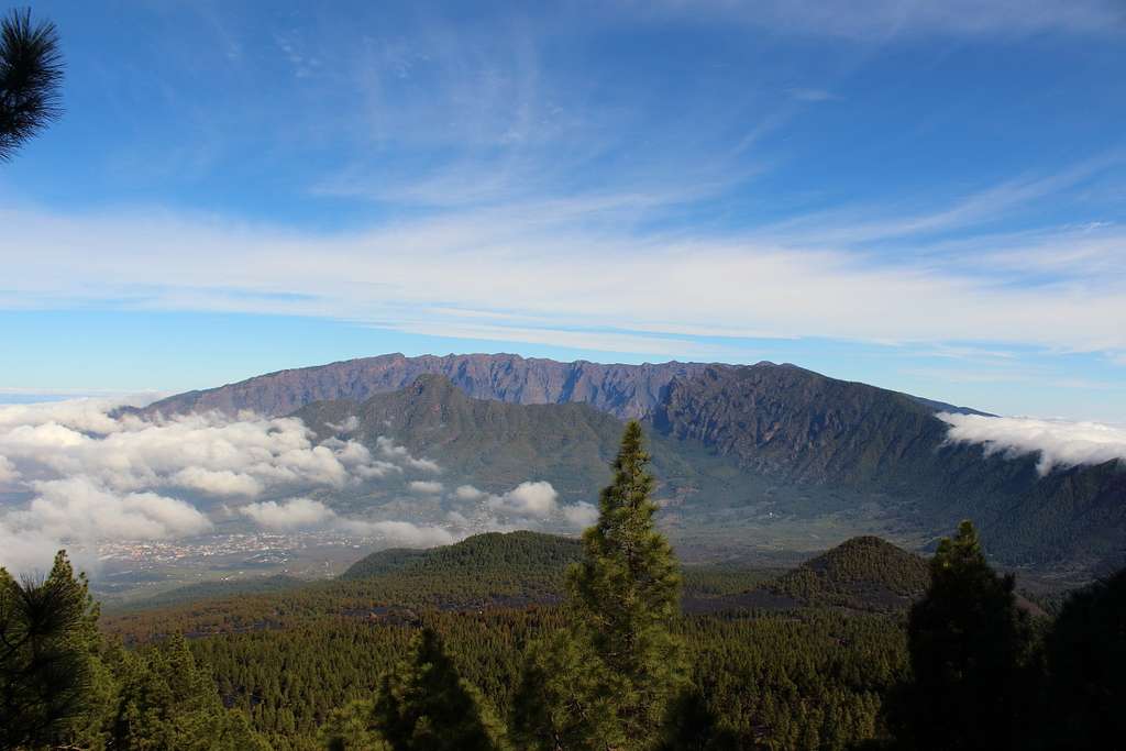
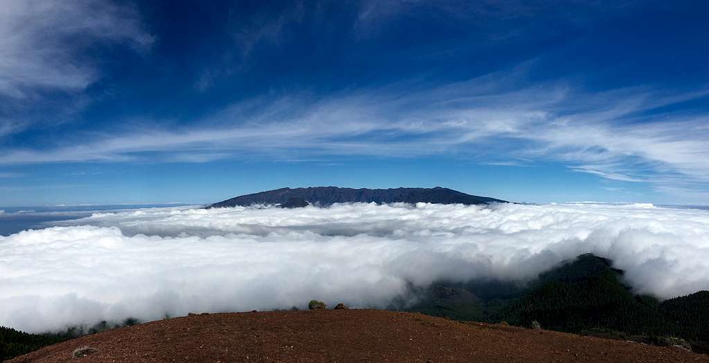
We soon got a view northward towards the summit of Pico Bejenado and the rim of the Caldera de Taburiente, the highest point of the island.
“This is more like what I was expecting.” I said to Marie.
Clouds were forming beneath the high ridges, just like the pictures I had seen and I fully expected us to be soon traversing our sunlit ridges above the clouds.
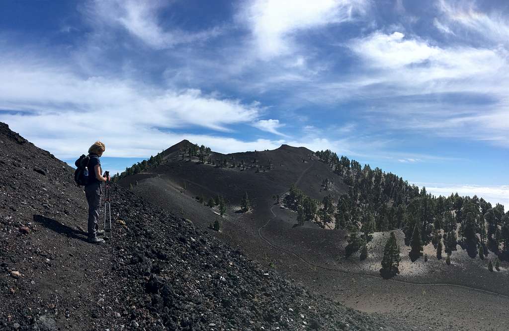
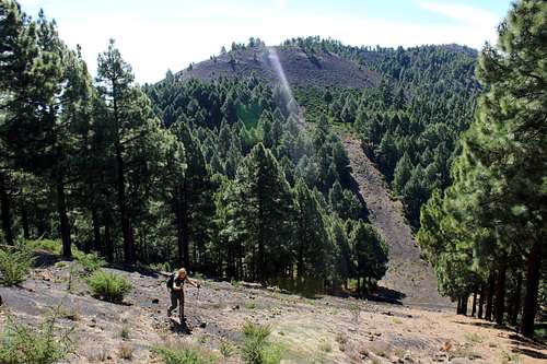
Most of the route at this time follows the GR 131 path through the pine forest on the west slopes of Pico Birigoyo – one of the summits we were reluctantly missing out – before it rises to climb Pico Nambroque, further south.
Through the trees around us, we could see streams of cloud being blown up and over us but the going wasn’t too bad. The forest floor was covered by a carpet of the long needles fallen from the local Canarian pines mixed in with jet black volcanic dust. Had this dust been deposited a long time in the past or was it from the recent eruption of the relatively nearby volcano, Tajogaite? We couldn’t be sure.
We reached a turn in the path and stopped for a drink. Our route went right (south) but the route straight ahead (east), was not signposted. The German couple caught us up and we said “Hi” as we continued and they stopped. Some time later, I looked back. They were no longer following us, so I presumed that the un-signposted route must have taken them up and onto the northern summits – more on this later!
The GR 131 emerged from the trees onto an open slope of ash and rock with much sparser vegetation cover. We were now in the northwest wind which blew the cloud across the landscape. The ground itself looked like it was hot and steaming but it was only the wisps of cloud being shredded by the abrasive surface that created this effect.
As we continued the cloud cover increased and we followed the marked path through the mists with only occasional views. To our right, a huge hole appeared in the mountainside through the mist, Crater del Hoya Negro. We knew this had been part of the 1949 eruption from our visit to the volcano visitor centre.
I spent some time photographing the scene but we knew we had to continue.
Soon we came to a signpost for Pico Nambroque, a summit to the east, just off the main ridge. We followed the path for a short distance until we reached a small crater with a rocky outcrop on one side. It was very cloudy here and I walked a circuit of the crater, peering into the mist. The slopes fell away steeply – nothing down there, I thought.
“Is this it?” Marie asked.
“Seems a bit small.” I replied. “But there’s nothing down there so, it must be.”
“Let’s keep going then.” Marie replied.
It was already 10.40 am and we had no idea how long the route might take us.
We didn’t realise it at the time but we had not seen Pico Nambroque, it was lost in the clouds.
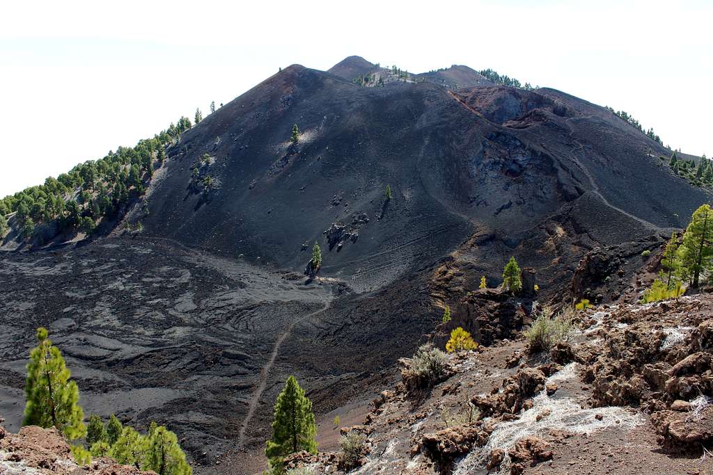
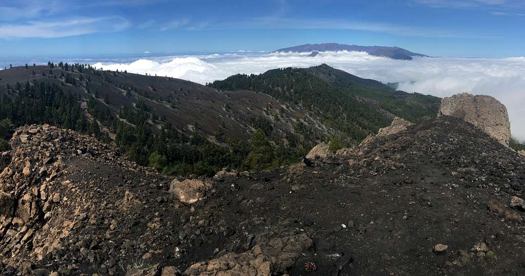
Soon, the cloud started to clear a little and as we climbed to a viewpoint at a strange rock formation, we got a clear and fantastic view. I had seen a picture of the Montana del Fraile and the feature known as the Lavas la Malforada but the real thing was much more spectacular.
Another part of the 1949 eruption, the lava flow beneath us must have been a boiling cauldron of molten rock which quickly solidified, leaving a black, crusted unearthly surface.
We descended the rim of this crater and reached another fork in the path. I really wanted to follow the rim and head on and up the higher route but our path – the GR 131 - descended around on lower ground.
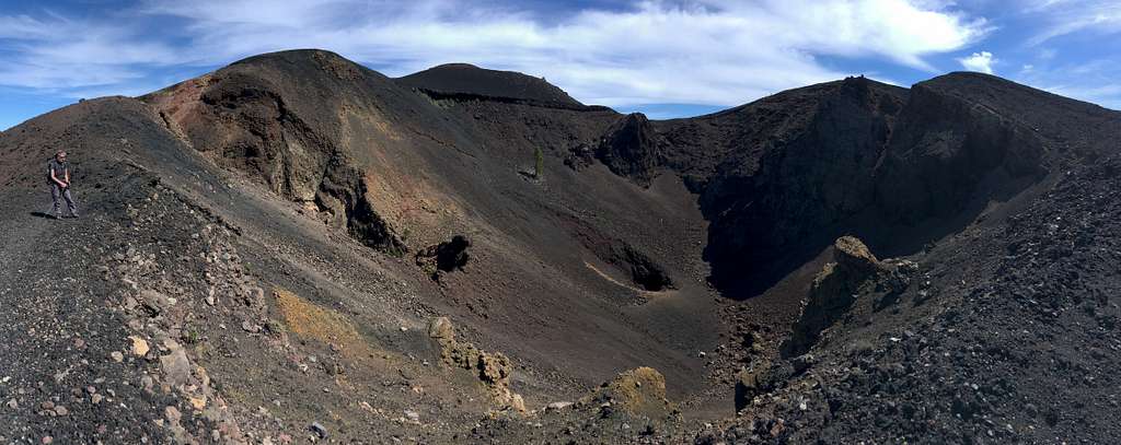
We stuck to our plan and descended the path across the open, barren landscape. Soon, it started to rise again up the hillside towards the next summit, Deseada 2.
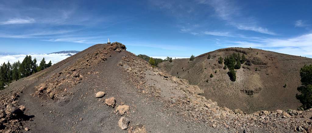
This stood on the west side of a crater, with a rather incongruous concrete plinth showing the summit of Deseada 2. Across, on the other side of the crater, we could see the cairn of the higher summit, Deseada.
We headed around to this for more pictures and a spot of lunch. We managed to find some shelter from the wind on a shelf of lava rock near the summit.
Up to this point, we had seen no one since the German couple had gone a different route around 10.15 am. At 12.30, they caught up again and passed us on their way to Deseada 2.
From here, our guidebook said, the route is all downhill! It felt we had done it quickly but that was just an illusion! We passed the Germans again; they had stopped for lunch on Deseada 2. I assumed we would see them again later but they seemed to give us a quizzical look as we passed, as if to say, “Where are you going?”
We didn’t see them again, so I assume they returned to their car at El Pilar?
As we descended southwards, the cloud started to increase. It had not really been that warm before but now it got cooler. The GR 131 passed between several cloud covered hillsides, the guidebook and map shows Montana Negra, and Montana los Bermejales amongst others but it was difficult to know exactly what was what in the mist. We traversed around what we presumed was the Caldera del Bucaro on the path and eventually, I decided to detour onto what I thought might be Montana Cabrera for a view.
The clouds had other ideas and I saw nothing except vague rocky outlines in the mist.
We came to a signpost for Volcan Martin and I insisted on following the track upwards. Marie followed reluctantly and we were soon right in the strong wind which blew across our ridge. The cloud was thick and wet – I noticed a bush dripping with moisture from the mist collected on its leaves – my left lens on my glasses was covered with droplets.
We reached the top and the rim started to descend, still we saw nothing.
“I’m getting cold here.” Marie said.
She put her waterproof on and started to descend the way we had come up. I waited for a few moments, hoping for a clearance in the cloud but it never came.
Back on the GR 131, it was still cloudy. We carried on and during the next hour or so, we met some people ascending albeit, a bit late in the day.
We picked up a companion along the way as a Raven followed us from tree to tree for about 15 minutes. Presumably, he wanted something to eat.
We descended into the pine forest and clouds. The path was really rough, not the easy descent we were hoping for.
We reached Los Canarios around 4.00 pm in cool gloomy weather. It was great to have completed the route but a shame about the clouds.
Perhaps the weather here is never good, we wondered?
------------------
A week later. It was our last day. The weather had thwarted our plans on several different occasions and I would have liked to have climbed Pico Birigoya. The weather forecast for the last day was not great on the Cumbre Vieja – cloudy all day - and we had a slow, unenthusiastic start to the day.
Eventually, around 10.30 am we found ourselves at El Pilar again. The taxi we had found to take up was old and dirty, our driver had overcharged us then, not put the meter on and then, nearly ran out of petrol! Not a great start.
The taxi had driven through cloud on the way up and I was convinced we would soon be covered by it again.
We set off – Marie realised her water bottle had fallen out in the back of the taxi so now we were short of water too.
We repeated the route we had started before, traversing around the west slopes of Pico Birigoyo. At the turn in the GR 131, this time we continued on straight, up the gentle hill and into some sunshine.
We reached a sign pointing uphill to the north telling us to keep to the path but not where it was going!
|
|
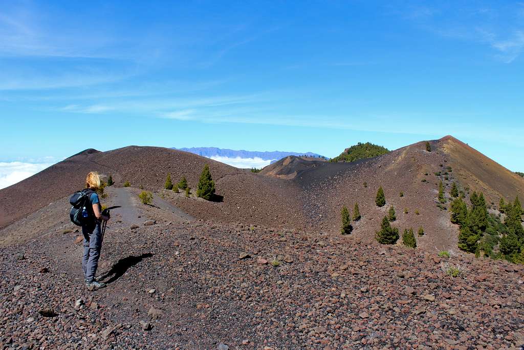
We started up a steep zig zag path into brilliant sunshine and views over the clouds on either side of the ridge. I had decided this must be Montana la Barquita and soon we reached a small cairn amongst the few trees on what appeared to be the summit.
Ahead and to the north, the ridge descended then rose again to the summit of Pico Birigoyo. The path was rather vague and several times I lost it, only to find it again quickly. Luckily, there were boot prints in the dust for me to follow through the very tough vegetation.
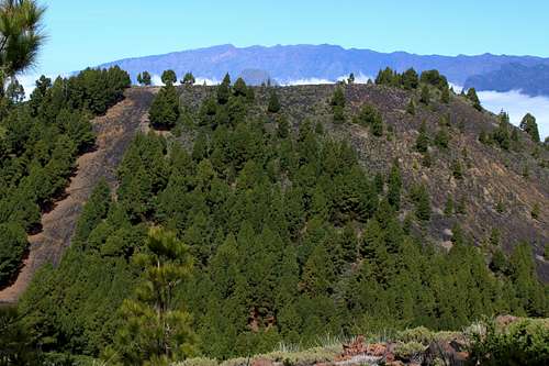
We reached the summit ridge and passed the few trees along to another solitary concrete post at the end and just below the summit of the Pico Birigoyo.
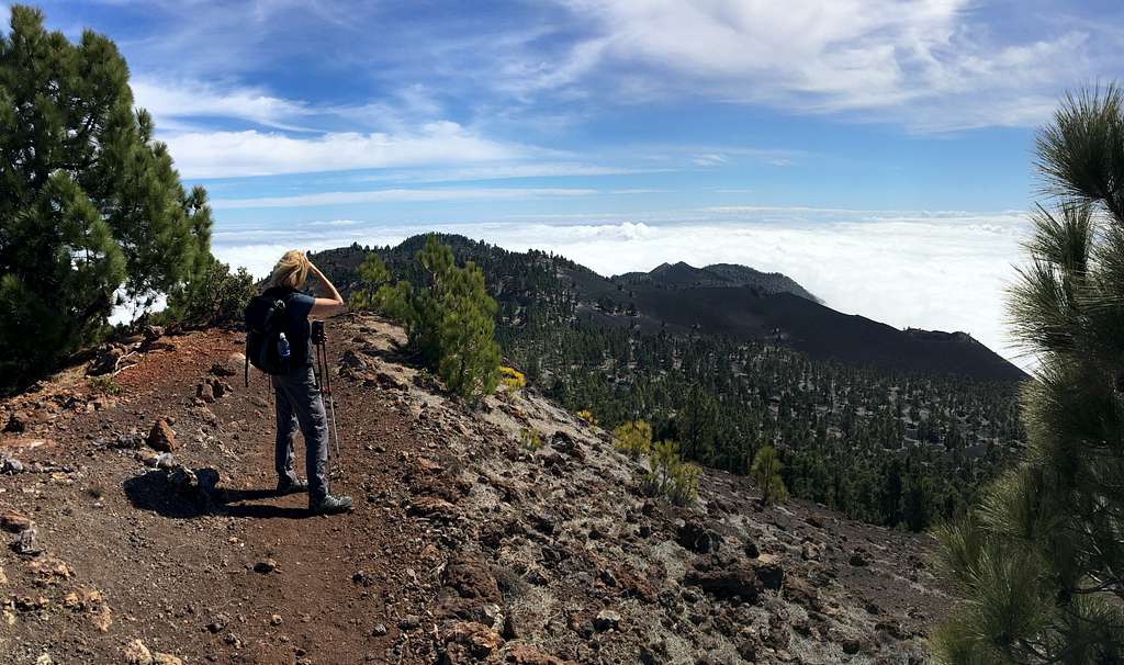
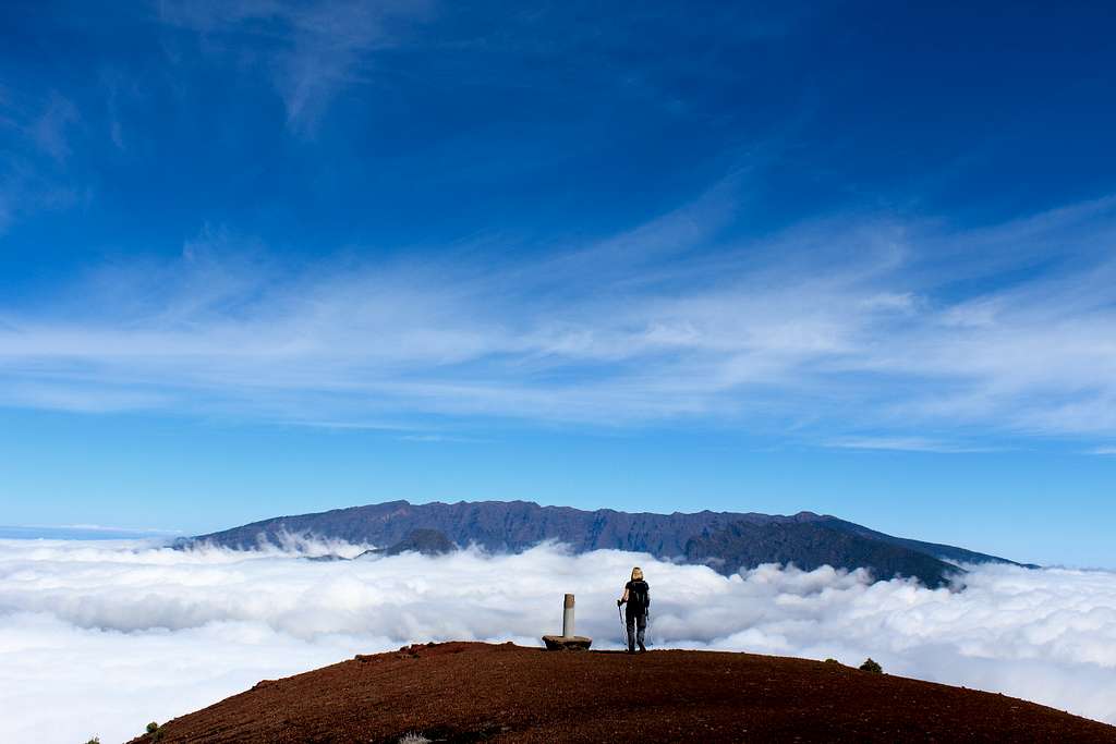
We were in perfect sunshine. A light wind blew from the west and the white clouds boiled in the valleys beneath us. We had great views northwards – Pico Bejenado poked its head out of the ice cream like cloud cover!
Tenerife and La Gomera were visible to the west, floating above the whiteness and we could see that the ridge ahead of us was clear. I didn’t believe it would last.
We retraced out steps and marveled at the views.
“The weather forecasts here are a complete work of fiction!” Marie proclaimed at one point.
We re-climbed and descended Montana la Barquita and headed straight up again towards Montana de los Charcos, another new summit marked with an old concrete post. Along here, the path was very vague and I was following the tracks made by a mountain bike to stay on course.
Again, we continued southwards. I had started to believe the weather would last but was unsure how far we could go.
By 1.00 pm, the troops were revolting!
“I’m starving, when are we stopping for lunch?” Marie demanded.
We could see we were nearly due to rejoin our route from the previous week, so we stopped to sit on some rocks on a small highpoint.
“I can’t believe the weather is so good.” I kept saying. “We must keep going.”
I think Marie was starting to worry about just how far that might be but she didn’t complain!
We had two companions for lunch – two Ravens this time! They were very bold! They sat on rocks near us and hopped around without fear.
We re-joined the route from the previous week.
“What’s that mountain over there?” Marie asked.
I had seen it a few minutes before and a worrying thought was growing in my head.
“I wonder if that is actually Pico Nambroque and we didn’t see it in the clouds last week.” I said.
We reached the turn off for Nambroque and I was convinced I was correct.
Marie decided that she wouldn’t do it but I decided I had to. I descended as quickly as possible, found the path around it and 5 minutes after leaving Marie. I was on the summit. A sign confirmed it for me!
I took a few pictures and returned to her.
“You never went to the top? Not that quickly?” Marie said when I returned, out of breath.
I showed her the pictures to prove it and we were off again.
We passed the Lavas la Malforada again and this time ascended the higher path on Montana del Fraile to the Crater del Duraznero. It all looked fantastically surreal in the sunshine.
The rock is more like molten ash from an enormous fire than any rock I have seen before. It is melted into swirling shapes and reminds me of road tarmac.
“Mike, when are we going to start heading down? It’s already 2.30.” Marie asked.
I was actually aware of this and the fact that our water had nearly gone.
Originally, I had thought we would return towards Pico Nambroque and head down to the town of Mazo but now I realised that was too far back along the ridge to do.
We decided to continue over Deseada 2 and down to a path (PR LP 15) to take us down to the town of Tigalate. I had no idea how long this would be – I even considered going all the way to Los Canarios – but we thought it would work.
We reached the path to Tigalte at 3.00 pm. It showed as 5.5 Km down – much shorter than the 9.6 km to Los Canarios – but had a descent of around 1200m!
It started really easily as a broad track through the pines.
“This is good but I can’t help notice that we’re not going down!” I said as we bade farewell to Deseada above and the volcanic peaks of the Ruta de los Volcanes.
The track became narrower, rougher and started to descend through the pine forest.
It got steeper and we got slower!
After an hour we took a rest near the 1.9 km signpost, we were nearly there!
Or so we thought, the path descended steeply, through rough ground, crossing a track several times. The time ticked on. We passed into the cloud and the forest became gloomy.
I couldn’t believe the last 2 km was taking so long. We were hot, thirsty and desperate to finish. The adrenaline I had been running on had dissipated.
We finally emerged onto a road at 5.00 pm – the time we knew the bus was leaving Los Canarios! It was grey and overcast – difficult to believe we had been up and above the clouds.
We hurried down the road, trying to ignore the barking dogs!
On the coast road, I saw the bus coming.
“Come on!”.
We started running and reached the main road but there was no way we would reach the bus stop in time.
The bus came around the corner and I gave up running.
Marie jumped up and down with her hand out… the bus driver stopped. We had made it!
When the conditions are good, this is a fantastic route through a surreal and sometimes unearthly environment. There are many different options to choose from depending on time, fitness and conditions but it is really worth it just to see it. It is seen at its best when you can traverse through the low lying clouds to the calm, clear weather above and enjoy your traverse in the sunshine. However, it may take more than one attempt to acieve this.