
-
 4685 Hits
-
 86.85% Score
-
 23 Votes
|
|
Route |
|---|---|
|
|
44.68904°N / 7.07527°E |
|
|
Trad Climbing, Sport Climbing |
|
|
Summer |
|
|
Most of a day |
|
|
TD inf., UIAA VI |
|
|
5.10a (YDS) |
|
|
Overview
Ti' Punch
Punta Roma is a massive peak standing out on the main watershed on Italy-France border, between Po valley and Guil Valley. It is one of the best known mountains in the Monviso Group, lying to the South of the adjacent Punta Udine, from which Punta Roma is joined by a long and notched ridge, and to the North of Punta Gastaldi.

Punta Roma has a lot of interesting routes; the hardest ones are located on the shady and wide West face on the French side. Amongst these latter a very interesting and pleasant route is just "Ti' Punch", running on excellent “gabbro”, a kind of rock similar to the gneiss. Another fine easier route on the same West face is “Trois Rivieres”. Punta Roma West face can be reached both from Italian side and French one. It’s a cold “milieu”, as a matter of fact the wall gets the sun at 11 o’clock at the height of summer.
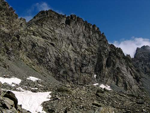
The wide Punta Roma West face
Getting There
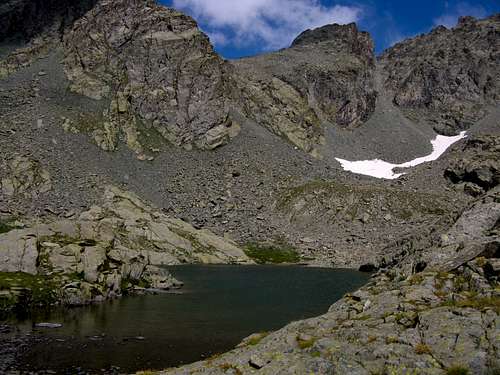
Porcieroles Lake
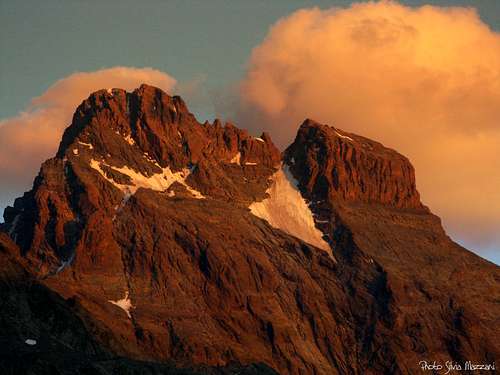
Monviso West face at sunset seen from Refuge du Viso
Road access
ITALIAN SIDE: From Torino to Saluzzo, then follow Po Valley reaching Paesana, Crissolo and Pian del Re, where the road ends.
FRENCH SIDE: From Guillestre follow D902 towards Queyras – otherwise you can approach from Briancon via the Izoard Col - reaching Chateau Queyras, Abries and Ristolas; from Ristolas take an unsurfaced road leading to Roche Ecroulèe parking m. 1787. The acces by car is not allowed after Roche Ecroulèe.
Huts approach
Refuge Giacoletti - From Pian del Re m. 2020 follow the path to Quintino Sella Hut (V13 and GTA), reaching Fiorenza Lake. After the lake, at 2310 m., leave this path and follow towards right the path to Giacoletti Hut (V14), reaching a new lake, named Chiaretto Lake. After gaining Viso Pass m. 2650 – a spectacular view over Viso Great Lake – the path leads to the hut (2 hours and a half from Pian del Re).
Refuge Viso - From Roche Ecroulèe follow by walk the road to Belvedere du Viso m. 2133. From here follow the path rising towards East until a forking at 2437 mt., where you must turn to right following a mainly level path towards the well evident hut (2 hours and 45 minutes from Roche Ecroulèe).
Ti' Punch report
Ti'Punch report (French Scale)
Summit altitude: m. 3070
Difficulty: TD inf.
F6a max
Equipment: bolts
Climbing length: 300 m.
Exposure: W
First ascent: Richard Clermont – Sylvain Pusnel 1996
Starting point: Pian del Re (Italy) m. 2020 (parking) or Rocheè Ecroulèe (France) m. 1787 (parking).
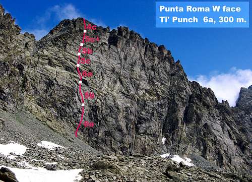
Ti' Punch topo route
Approach from Viso Hut - Don’t take the path heading towards SSE to Valant Col, but follow a less obvious track heading to East as far as Porcieroles Lake. From the lake don’t carry on towards Porco Gully, but turn to right rising along slabs and stones heading to the obvious high serrated W face of Punta Roma. Starting point is on the left-hand side of the face; last route on the left is “Trois Rivieres”. Ti’ Punch start about 60 mt. on the right of “Trois Rivieres” and on the left of a great steep black zone, rising along some easy steps just below a white quartz intrusion.

Approach from Giacoletti Hut - Follow Porc Gully (Couloir del Porco) and via ferrata, reaching the pass. Go down to Porcieroles Lake. From here follow the previous approach.
Route report
L1 – Little steps and walls towards the white quartz intrusion, then a corners’ line ligthly slanting towards right; a steeper shallow corner – crux move – leads to a belay. 4c, then 6a
L2 - Climb a corner, then leave it and climb towards right a fine slab with cracks. 5b

L3 - Easier rocks and some slabs lead to a steep wall. Climb it with fine movements. 6a
L4 – A short pillar (short 5c “bloc”), then a smooth little overhang; slantways towards right climb some slabs with thin cracks becoming steeper in upper section. Belay below an orange corner. 5c, then 4b and 5b.
L5 - Climb the corner’s right face, then some slabs and little walls slantways towards right. 5b

L6 - A short wall, then a steep slab with a crack. Climb the crack on the right-hand side of the pillar’s edge, then a steep wall. 5c+
L7 – A short steep chimney-crack leads to some steps and to a belay below summital ridge. 4c, then 3a.
L8 – Along the summit ridge towards left to reach Italian summit (Summit Book and Mary’s statue) 3a.

Descent to the Italian side: along SE Italian Normal Route (2b) to Giacoletti Hut.
Descent to the French side: from Italian summit get back along the summit ridge to last belay. From here rappel the route.
Essential Gear
Rope 2 x 50, helmet, nuts 3-9, friends 1-3, ten quickdraws
Red Tape

There are no particular restrictions in climbing and hiking.
Huts

- Rifugio Giacoletti 2741 m
Owner: CAI (Italian Alpine Club - Barge)
Guardian: Andrea Sorbino
Open: from 15-6 to 15-9

- Refuge du Viso 2460 m
Owner: CAF (French Alpine Club - Briancon)
Guardian: J. Bellier-Fouchard
Open: from 15-6 to 15-9
When to climb

Best months are July, August and September.
Meteo
Meteo Regione Piemonte
Meteo France
Meteo Alpi
Guidebooks and maps

Guidebooks
“Monte Viso – Alpi Cozie Meridionali” by Michelangelo Bruno – Collana CAI-TCI Guide dei Monti d’Italia
“Pays du Viso – Escalade en Queyras entre France et Italie” by Sylvain Pusnel and Guillaume Vallot

Maps
"Monviso-Valle Varaita-Valle Po-Valle Pellice" - IGC sheet 106 1:25000
Monte Viso countries


