
-
 4903 Hits
-
 87.76% Score
-
 25 Votes
|
|
Route |
|---|---|
|
|
46.49194°N / 12.04982°E |
|
|
Trad Climbing |
|
|
Summer, Fall |
|
|
Half a day |
|
|
Alpine D, max V- UIAA |
|
|
8 |
|
|
Overview
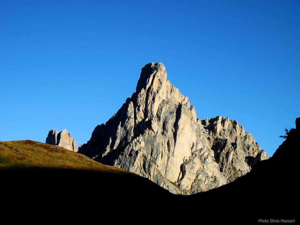
Geographical classification: Eastern Alps > Dolomites > Cortina Dolomites > Ra Gusela > Via Dallago
Via Dallago - Gusela del Nuvolau
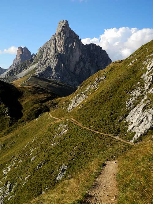
A sharp and steep tower in shape of a triangle rises just above the green meadows of Passo Giau, one of the highest road-pass of the Dolomites: it’s the Gusela of Nuvolau 2295 m. This attractive peakoverlooks the Northern side of the pass, the right one when getting there from Cortina d’Ampezzo, and irresistibly attracts the gaze of tourists and climbers.

There are several ways to climb the summit, including even some routes for experienced hikers (Via Ferrata) rising on the gentle angled Northern side ; definitely the more classic and repeated climbing route runs on the South-West wall of tower, facing just to Passo Giau, is the route Dallago, leading to this wonderful and panoramic summit by a climb of medium difficulty (UIAA grade IV) with a single step of grade V UIAA in the second pitch.
Getting There
The starting point to climb Gusela is Passo Giau m. 2236, one of the highest pass of the Dolomites, located 16 km. from Cortina d’Ampezzo, the main resort in this area, and 10 km. from Santa Fosca. Passo Giau can be approached both from the Northern side (Cortina or Falzarego route) and the Southern one (Selva di Cadore and Santa Fosca).
Road access to Passo Giau m. 2236
- From Belluno: follow the road SS 51 towards North reaching Longarone and Pieve di Cadore; from Pieve the SS51 turns to left, getting to San Vito di Cadore and Cortina d’Ampezzo. In Cortina take the road SS48 to Falzarego Pass and getting to Pocol turn to left (signpost Passo Giau), following the Road SP638 to Passo Giau (16 km. from Cortina).
- From Trento and Verona: take the Brennero Motorway towards North, exit Ora-Egna, then follow the road to Val di Fiemme and Val di Fassa, pass Cavalese and Predazzo; in Moena leave the main road and turn to right, following the Val di S. Pellegrino road to Falcade and Cencenighe Agordino. Here turn to left following the road to Alleghe, Caprile, Selva di Cadore, Passo Giau.
- From Bolzano: take the Brennero Motorway towards North, exit Ponte Gardena and then follow the Val Gardena road to Selva di Val Gardena and Passo Gardena, reaching Corvara and La Villa. Turn to right towards Passo Falzarego, get the pass and here descent towards left along the road SS48 towards Cortina d’Ampezzo as far as Pocol. In Pocol turn to right and follow the road to Passo Giau (signpost).


Walking access
From Passo Giau m. 2236 take the path n. 452 towards the Rifugio Averau, getting soon a fork. Head to left and when arrived in the vicinity of the first rocky outposts leave the main trail to the refuge Averau and climb on the right side heading to the wall (30 minutes from the pass).
Route Description
Via Dallago report - UIAA Scale
Summit altitude: m. 2595
Difficulty: D, max UIAA V-
Equipment: pegs
Climbing length: 250 m
Exposure: South-West
First ascent: F.Dallago, A. Dallago, G. Valle, P. Michielli, A Menardi, D. Costantini 1970, june 14th
Starting point: Passo Giau m. 2236

A satisfactory climb on excellent rock and full of handholds, especially at the beginning, where it follows a vertical line of fine cracks. On the slabs of the upper section the itinerary is not obliged.
Approach - From Passo Giau m. 2236 take the path n. 452 towards the Rifugio Averau, getting soon to a fork. Head to left and when arrived in the vicinity of the first rocky outposts leave the main trail to the refuge Averau and climb on the right side at first along a scree, then on easy rocky steps, reaching a grassy terrace. Cross the terrace to the left, downclimb about 20 meters, getting a ledge at the base of the wall. The starting point is below a fine crack. Cairn (30 minutes from the pass).
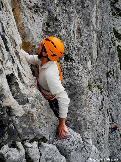
L1 - Climb the beautiful starting crack, then the left one, reaching a small terrace - IV, III, 25 m.
L2 - Traverse left toward another crack, take a flake and with an airy move reach the main chimney-crack (crux), pass a jammed block and belay inside a niche - V-, IV, 20 m.
L3 - Up again the chimney-crack, then exit left to a stance - IV, IV+, 20 m.
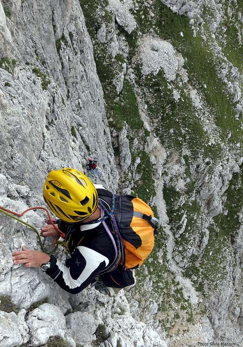
L4 - Climb directly the wall above the stance, then left to a slanting crack. Up the crack, then the right face of a yellow corner, exiting to a scree slope - III, IV, IV+, 40 m.
Via Dallago third pitch |
Airy climb |
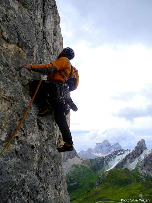
Steep wall |
L3 - Up again the chimney-crack, then exit left to a stance - IV, IV+, 20 m.
L4 - Climb directly the wall above the stance, then left to a slanting crack. Up the crack, then the right face of a yellow corner, exiting to a scree slope - III, IV, IV+, 40 m.
L5 - Climb the scree slope heading to a yellow spot and reach a ledge under the spot - I, 40 m.
L6 - Climb the short wall above the ledge (almost reaching the spot), then climb a crack; easier rocks lead to another short and deep crack - III, III+, 35 m
L7 - Up the crack, then slanting left on easy steps reach a good stance - III+, 30 m.
L8 - Traverse left, gain a cracks system, leading to easier rocks and to the summit - III, II, 40 m.

Descent: two possibilities
A – Follow the cairns and the tracks in the direction of Cinque Torri (North) reaching the crossing with a well worn path coming from the Nuvolau. Turn to right taking this path, leading to the short Ferrata della Gusela. Follow the Via Ferrata reaching the meadows near Passo Giau. (40 minutes from the summit)


B – A longer way to descent to Passo Giau – very advisable in reason of the wonderful views – is the following: reach the nearby Nuvolau and the shelter built on its summit, then descent to the Rifugio Averau and follow the path 452 to Passo Giau.
Essential Gear
Rope 2x50 m, helmet, slings, nuts and friends, 8 quickdraws.Red Tape
No particular restrictions in climbing and hiking. Free camping is not allowed.When to climb
Best season goes from June to middle OctoberWhere to stay

- Rif. Passo Giau 2236 m.on the pass
- Rif. Fedare on the road to Passo Giau (Southern side)
- Rif. Col Gallina 2054 m. on Passo Falzarego road.
Dolomiti Meteo Veneto
ARPAV DOLOMITI METEO Phone +390436780007 fax +390436780008
CENTRO VALANGHE DI ARABBA Phone +390436755711 fax 043679319 e-mail cva@arpa.veneto.it
Meteo
ARPAV Dolomiti MeteoDolomiti Meteo Veneto
ARPAV DOLOMITI METEO Phone +390436780007 fax +390436780008
CENTRO VALANGHE DI ARABBA Phone +390436755711 fax 043679319 e-mail cva@arpa.veneto.it
Guidebooks and Maps
Guidebooks


“Arrampicare a Cortina d’Ampezzo e dintorni – Le vie più belle nelle Dolomiti” by Mauro Bernardi, Ed. Athesia
"IV grado in Dolomiti" by Emiliano Zorzi, Ed. Idea Montagna
“Dolomiti Orientali Vol. I – Parte I” by Antonio Berti - Collana Guide dei Monti d’Italia, CAI TCI
Maps
Tabacco sheet 03 – Cortina e Dolomiti Ampezzane 1:25.000
Kompass sheet 55 - Cortina d'Ampezzo 1:50.000