
Comments
No comments posted yet.
It’s pretty much like "Inception"—someone puts an idea in my mind and it guides my actions. This time—‘twas the two old timers on Mt. Whitney, talking about the “Southern Six Pack” (SSP) and how you can just do them all at once over a long summer weekend.
Everything except the summer part sounded good to me—six state highpoints all over one venture without long flights or drives in between. In a sense, dwelling in Ohio is great for highpointing because of its Midwest central location. Driving anywhere east of the Mississippi can be accomplished in a day. The bad thing about living in Ohio is that it is extremely flat. No White Mountains in my back yard to play around on. So all of my climbing and hiking has been learned “on the job,” so to speak.
Logistics, not the climbing, would be the most difficult aspect of this task. My goal is to summit every state highpoint east of the Mississippi in winter. Why? One, if I’m going to drive 16 hours to Mt. Washington, I sure as shit don’t want to share the peak with some obese food addict eating ice cream while running the AC on blast in his Oldsmobile in the parking lot. Two, I need the experience and training that can only come from eastern peaks if they are done in the winter season. Three, the adventure and four, the notoriety. We’re not talking about the Sharks Fin on Meru Peak or anything, yes, I realize, but I’d like some distinction among highpointers.
The most frustrating and hardest things to conquer when winter highpointing is dealing with road closures. Once you’re at the trailhead, bring the weather on. But adding an extra five or 10 miles to your trip by hiking up a closed road is simply not what you signed up for.
So attacking the SSP needed a clairvoyant plan of attack. Or luck. Yep. Just luck. Again, living in Ohio, you have to plan these trips months in advance, so waiting out weather patterns and storms simply isn’t a possibility. Family, work, time, money, blah, blah. So I planned to leave Ohio the day after Christmas, and adjust my route based on what roads were open.
Speed also became a big issue. Since the SSP, even in winter, was going to be a bit of a down grade in terms of technical ability and skill, I wanted to up the ante a bit and try to complete it as fast as possible.
Naturally, I got on the SummitPost forum and asked about records. Did the same for Fastest Known Times and the highpointers page on Facebook. The record for the SSP in winter was nine days. That “expedition” was obviously taking their time. They also had to wait out weather and storms. Or choose to do so.
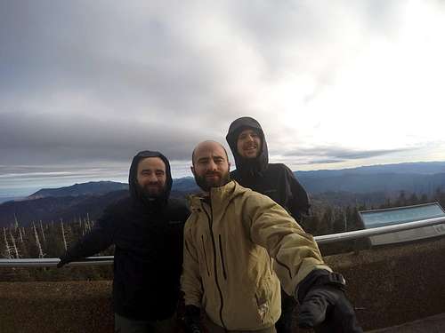
With all the navigating and logistics, I wanted a climb team. Cody and Travis, my 25-year-old still-in-shape-from-college-soccer twin cousins joined the team and Travis gave us the name, “The Summit Slayers.” You had the driver, the navigator in shotgun and the guy in the back was in charge of food and snacks.
Ohio to Gatlinburg, TN, to Newfound Gap
Believe it or not, the National Park Service has numerous Twitter accounts that they use to update road closures and to distribute information. Guess it’s not surprising to Millennials. Every other day the Great Smoky National Park tweeted (from @SmokiesRoadNPS) that “US Hwy 441/Newfound Gap Rd from Gatlinburg, TN to Cherokee, NC is temporarily closed due to snow/ice.”
At London, Kentucky, we had to make the call. If 441 was closed, we had to head towards Kentucky and do Clingmans Dome last. (Which could also mean we would be hiking 22 miles roundtrip instead of 16, if we couldn’t reach Newfound Gap and thus would be forced to take a lower-elevation trail.)
We almost didn’t get to London due to gas. I borrowed my parents Ford Explorer and couldn’t fill up in Kentucky. Imagine three idiots at a gas pump trying over and over again to slam the pump into the slot. Turns out the old pump nozzles at the non-chain gas station were a slightly different size, and thus wouldn’t open the release to fit the nozzle in.
Two miles from London, Twitter informed us that Hwy 441 was open! On to Gatlinburg. (I will spare you the horrors I encountered in that invented city. Buy, buy, buy, nothing that you need while watching five different ways to make taffy. All for eight times the actual and ethic price.) We found fuel in carbs at an average Italian place downtown and headed for Newfound Gap to camp for the night.
Yes, it would have been nice to get a hotel room and start fresh in the morning. But we couldn’t risk the Smokies string-pullers closing Hwy 441 while we slept. We would have to take our chances with an illegal camp spot around the Gap. Two minutes from the Gap parking lot a ranger was heading north, back towards Gatlinburg. We were hoping he had just completed his last inspection of the area for the evening.
It was close to midnight when we hopped onto the blacktop of the Gap parking area. Where’s the fucking snow? It’s only 35 degrees and we’re at 5,000 feet in winter? What the hell?
It was one of the weakest Decembers on record throughout the country, with high temps having melted the previous mountain snowfall from November. Definitely didn’t need my Everest-rated salmon sleeping bag that I used when it was -14° F one night around Mt. Marcy (see my Mt. Marcy trip report for full details).
We even decided the rain flap wouldn’t be needed. Without any real flat areas to camp, we threw our tent over the stone wall lining the parking lot and camp on the giant flat pavers that composed a walking path behind it. Best night of stoned sleep I ever got. Ha.
At 3 a.m. it did, in fact, start to rain. I got up. The twins? Cody didn’t even move. Travis sat up for a second and then quickly dove back into his sleeping bag of protection. “Don’t worry dicks, I got it.” The wind outside the tent reminded me I was on a mountain, and I needed to have respect. I just yelled in the rain and climbed back in, learning nothing.
The Climb
I once started a short story with the line, “Beep, beep beep—there’s nothing worse than the sound of an alarm clock in the morning.” But on summit day, nothing could be further from the truth. After much tossing and turning, I eventually did fall asleep and my watch and Cody’s cell phone alerted me to the day’s mission at 5 a.m.
On summit day, all the bullshit is over with. No more dealing with getting off of work, family and pet arrangements, travel, saving money, planning the route, getting new equipment, conditioning, etc., etc. It never ends. But on summit day, it’s just you and the mountain. Your training, wisdom and experience versus (or coinciding with) the mountain. Yes, there is suffering and fatigue, but that’s all part of the climb and the fucking fun, brah!
Our bags were only damp but we packed away plenty of wet stuff with our headlamps on in the early morning chill and dew burnoff hours before dawn. There was a bathroom on the lot as well. Those are the little bonuses that help you start your hike off right.
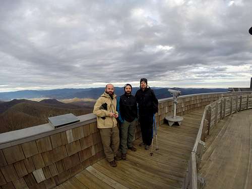
From the Appalachian Trail (AT) intersect at Newfound Gap, it is 7.9 miles to Clingmans Dome. You can also take the summit road that parallels the AT. We started up the AT at 5:22 a.m., Saturday, December 27, 2014.
The trail itself was nothing fantastic in one way or another. Reminded me of the AT in Shenandoah and other places I had hiked it before. A couple of good views but mostly a slow and steady approach up an established ridgeline. Half way up we still couldn’t believe the weather. Rising to the high 30s, sun, no snow on the trail and the ice and slick rocks were not much of a problem. Made it to the summit in 4 hours and 15 minutes, not trying to go too fast or get burned out too quickly.
Remember, with the road closures we would be hiking anywhere from 25 to 50 miles over the next week. Pace, but race, as runners say.
For the descent? We took the road. I know, so dumb. I was misled by someone online that the road offered amazing views and it was worth it for those. Not true. Yes, amazing views, but none better than the AT. And walking 8 miles down a road that looked exactly the same? Torture. And pounding the pavement. Uhggg. We were so mad. We were also told there was no water on the trail because of the high ridgeline. So we hauled 3 liters all day. There’s water. It’s not a raging river, and in low temps it may have been harder, but there was water to drink on both routes.
Off to Georgia
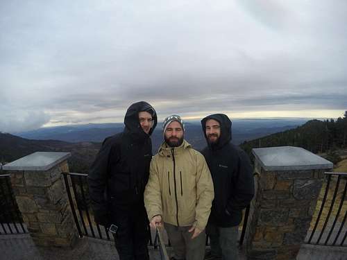
We were back in the car at 12:45 p.m., and started heading for Georgia and Brasstown Bald. There wasn’t much talking over the next two and a half hours. The 20 minute wrong turn and body fatigue all killed the team’s morale. I cheated with coffee at a gas station. Half French vanilla, half black. I was ready. And so was Brasstown.
The summit road was open all the way to the Brasstown parking area. We had planned to hike and do a nice 4-6 mile trek, but with so many cars we just couldn’t justify the hike when we could cruise.
In the planning, the hike would have been 1.2 miles, 4 or 6, depending on road access. Again, no snow or winter weather for us. It was so warm they even had the shuttle service open so if you were extra lazy you could still sit atop all the peaches without any physical exertion. We talked about our hiking philosophy. We came to climb but if the road was open we were going to take it. We planned this two months ago and it was set for winter. That’s all we could do. No shuttles to the top though. And it was a slow walk up—trying to loosen all the tightness after the 16 miles of Clingmans.
A half of a mile later we had summited Brasstown. The sun was just setting. Two peaks completed.
Actually a pretty impressive view considering we were in Georgia. Back to the car and to the lot. Too much traffic to set up camp and make dinner. Plus summit fever had me—must... keep... going.
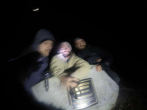
Close to three hours later we were a couple miles away from Sassafras Mountain, South Carolina. The mountain roads were pulling on the veins under my eyes, stretching them and making the blue more apparent.
The summit road was open. Might as well bag this peak real quick before the weather changes.
The top of South Carolina was one of the grossest high points I’ve seen. Fences and towers and electricity and man. And more man. And some debris. Even in the dark, a sad sight to see.
We had been going hard, 15 some hours, and had covered three states. It was time to make a decision about sleep (endless PB&Js and other car snacks had been lunch and dinner). Plus we had a big hike to the highest point east of the Mississippi early the next day. Just to be sure of everything, we decided to call the ranger at Mt. Mitchell State Park.
We found out that the Blue Ridge Parkway was open from the east, off of 70 and 80, and we could get into the park that way. The park was, however, closed until 8 a.m. the next day. So we pushed on and then slept four or five hours and were at the entrance to Mt. Mitchell State Park at 7:55 a.m. The drive along the Blue Ridge Parkway was nice. It’s true—they look blue in the distance.
Alone at the top. Another easy drive up. Summit number four of six had been completed. Two more to go to complete the SSP and to do it in record time.
Time to play with the wild ponies on Mt. Rogers.
(Please see the Mt. Rogers trip report for the rest of the
story.)