
-
 9027 Hits
-
 71.06% Score
-
 1 Votes
|
|
Mountain/Rock |
|---|---|
|
|
39.11496°N / 111.45378°W |
|
|
San Pete |
|
|
Hiking, Mountaineering |
|
|
Spring, Summer, Fall, Winter |
|
|
11130 ft / 3392 m |
|
|
Overview
Heliotrope Mountain is the highest peak in the southern portion of the Wasatch Plateau though it is often hidden from the surrounding countryside by its neighbors. Even from Twelve Mile Flat Campground near where the ascent typically starts, the summit is hidden by its expansive western shoulder.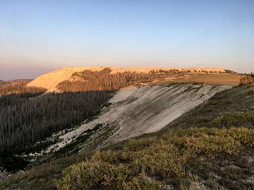
From the West Shoulder
Getting There
From Mayfield, drive east on East Canyon Road that turns into Forest Road 0022. Take a slight right after 5 miles onto Forest Road 0023. Drive for 0.6 miles and turn right onto FR 0290 or continue straight onto FR 0022. This is a well-maintained dirt road that veers northeast to Skyline Drive at Twelve Mile Flat Campground. Continue south and take an immediate left after the fence and follow the dirt road that switchbacks up the mountainside. Start the hike at the large primitive camping area.Route
From the primitive campsite, travel straight uphill following the path of least resistance. A series of faint paths appears and travel through a weakness in the steep terrain. Follow this game trail above the steep section of loose rock to the plateau above. If you lose the trail, simply work your way uphill. Once on top of the plateau, veer southwest through the sub-alpine terrain. There is a faint trail the meanders along the edge of the cirque to the north. From a distance, trails in the hillside of the summit block can be made out. Work your way through the open field on the plateau to any one of these trails to gain the summit.Round-trip Distance: 4 miles
Elevation Change: 870 feet