
|
|
Area/Range |
|---|---|
|
|
38.72500°N / 109.292°W |
|
|
6794 ft / 2071 m |
|
|
Overview
 The Aliens
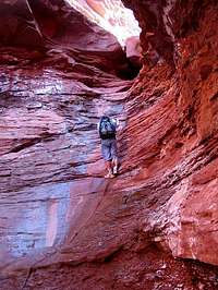
The Fisher Towers are located between Moab and Cisco Utah. The towers are some of the most spectacular and difficult summits to climb in North America. Not only are the summits difficult and spectacular, but these are among the most unusual and unique summits in the world. Also of interest are the smaller towers and canyons of Onion Creek. The whole area is a fantasy land of nature’s handiwork and even photos fail to capture the unusual beauty of the area. I can guarantee you will never see towers like this anywhere in the world!
Climbing the towers is for experts only, but those who are not in to hard core climbing can still enjoy hiking the Fisher Towers trail, or enjoy hiking part way up some of the canyons along Onion Creek. Emphasis of this page will be on the technical climbing, however.
The Cutler Sandstone forms the sides of the Fisher Towers, which are capped with the Moenkopi Formation. Despite their rotten appearance, the Cutler Sandstone is probably the hardest sandstone in Utah and is pretty solid. The climbing can still be dangerous however, because it is often covered with a layer of loose mud all the way up and down the towers. The conglomerate below the towers is not solid at all and is best avoided at all cost.
Excerpt from Selected Climbs in the Desert Southwest:
Welcome to the Fisher Towers, possibly the most challenging area for rock climbers in the Desert Southwest. If you get good here, you can go climbing almost anywhere in the world and feel comfortable on any kind of ground, including desperate alpine terrain.
Getting There
 The spectacular Fisher Towers with the snow clad La Sal Mountains rise above the Colorado River along state highway 128 northeast of Moab.
Fisher Towers Trail: To get to the trailhead, drive north from Moab along Highway 128, or south from Cisco on Highway 128 to the Fisher Towers Road, which branches east from Highway 128 between mile markers 21 and 22. Follow the road to its end at the trailhead. This road is good for all cars.
Onion Creek and C-1 through C-4 approaches: The Onion Creek Road also branches east from Highway 128 just west of the Fisher Towers Road and between mile markers 20 and 21. The Onion Creek Road is one of the most fascinating drives in the world and can be rough in places. The road crosses he creek many times, but in good weather, most cars can be driven to the trailhead if you drive slow. Drive up Onion Creek through the narrow canyon section with many towers. Park at the first major canyon coming in from the north. The trailhead is not marked in any way, nor is there a real trail here.
Notes on Page Setup
 The Titan stands 900 feet in the background.
Note #1: Many of the Towers proper names are in confusion. On the 7.5 minute map, what is labeled as the Titan is what locals call the Citadel, and what is known to most people as the Titan is un-named on the topo maps. On some maps, Totem Pole is one of two towers on the south side of Onion Creek and on some maps it is labeled on the north side. There is also confusion as to which tower on the south side is referred to as Totem Pole and to which is referred to as Hindu Tower. The names are switched on various maps.
Note #2: I could use some help with the page and any help is appreciated and welcome! Anyone who is knowledgeable about these towers is welcome to be a joint maintainter. I have not climbed all these towers, don’t intend to, and this would take a lifetime.
There are enough routes and towers in this area to spend a lifetime, and this is too big a project for any one person.
The page will be set-up with descriptions and approaches of the routes I have already climbed myself and routes and towers I haven't climbed will have links to the information.
If you have climbed any routes or towers, feel free to post the info, as individual “mountains and rocks” pages, or routes. This page is an "Area and Range" page.
Until more Routes and Mountain/Rock pages are added to summitpost, some routes will be linked to other sites.
Fisher Towers Trail
The Fisher Towers Trail is the most popular approach for the western towers such as Titan and Ancient Art. From the parking lot at the trailhead, the trail heads mostly east along a bench along the western towers base. The official trail ends after 2.2 miles, but the bench can still be followed and there are paths of use for at least another mile. Those who are not into hard-core climbing will enjoy hiking this spectacular trail.CLICK HERE FOR ROUTE PAGE
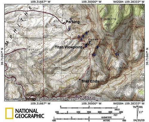
The Fisher Towers Trail is marked in red.
Tower ID
1: Lizard Rock
2: Dock Rock
3: Ancient Art
4: Cobra
5: Minotaur
6: King Fisher
7: Echo Tower
8. Cottontail Tower
9. Oracle
10. Titan
11. Hydra
"C" Ascent and Descent Approach Location
 These are the "C" ascent and descent approach routes to the Fisher Towers.
C-1 Approach
 Part of the C-1 Approach
The C-1 approach is a really fun approach to the towers. The route is mostly class two to four, but has a few 5th class pitches throw in for excitement. The most difficult move is a 5.8 chockstone move. No bolts are in place and none are required by competent climbers as the 5th-class pitches are all short. Those who don't want to climb the towers will find any of the C approaches to be exciting enough!
CLICK HERE FOR ROUTE PAGE
This route can be used to access Titan, Ancient Art, and Echo Tower, or east to Oracle, Hydra, Pillars of Hercules, Doric Column, Citadel, Mystery Towers, Doric Nightmare, and Atlas.
C-2 Approach
 Part of the C-2 Approach.
The C-2 approach is another fun route, and slightly easier than the C-1 approach. Most of the route is class two to four, with one class 5.2 move at the very top of the approach route.
CLICK HERE FOR ROUTE PAGE
This route accesses the same towers as the C-1 Approach.
C-3 Approach/Descent
 Chocksone obstacle on the C-3 approach.
This is the quickest descent route from the towers, but only experts can use it as an ascent route. What could have been the easiest and fastest approach ascent is interrupted by a 5.10 30' high chockstone. We were not able to surmount it without placing hardware, so we turned back and used it as a descent route, but a better climber could climb it.
CLICK HERE FOR ROUTE PAGE
This route is the quickest descent route from Hydra, Pillars of Hercules, Doric Column, Citadel, Mystery Towers, Doric Nightmare, and Atlas.
C-4 Approach
 Fixed rope section of C-4 Approach to Doric Column.
On the map, this route "looks" like the easiest approach to the eastern and central towers. Maps can be deceiving, however, and this route is more difficult than the C-1 or C-2 approaches. There is one 5.7 slippery pitch, midway along the approach, but this usually has a fixed rope in place making rather easy. The headwall , especially the west side is probably the scariest ascent I've ever made, so be warned.
CLICK HERE FOR ROUTE PAGE
The C-4 approach can be used to reach the eastern group of towers (Hydra, Pillars of Hercules, Doric Column, Citadel, Mystery Towers, Doric Nightmare, and Atlas).
The Titan
 The Titan
The Titan is a very fitting name. This is the Grand Daddy, the Big Kahuna of all towers in the United States. The Titan is the largest free-standing tower in the United States. Just viewing the tower up close will leave even the most jaded climber or hiker awestruck.
CLICK HERE FOR THE TITAN PAGE
Other (non-Summitpost) route links:
Finger of Fate
Sundevil Chimney
Worlds End
Gimp Warfare
Ancient Art
 Ancient Art
CLICK HERE FOR ANCIENT ART PAGE
The Cobra
 The Cobra
CLICK HERE FOR THE COBRA PAGE
Cottontail Tower
 Cottontail Tower(right)
CLICK HERE FOR THE COTTONTAIL TOWER PAGE
Dock Rock
 Dock Rock(foreground)
CLICK HERE FOR DOCK ROCK PAGE
Other (non-Summitpost) links:
Look See
Echo Tower
 Echo Tower
CLICK HERE FOR ECHO TOWER PAGE
Other (non-Summitpost) links:
Phantom Sprint
Run Amok
Tapeworm
Kingfisher Tower
 King Fisher (right) as viewed from the start of the Fisher Towers Trail.
CLICK HERE FOR KINGFISHER PAGE
Other (non-Summitpost) links:
King Fisher Tower
Colorado NE Ridge
Death of American Democracy
Lizard Rock
 Lizard Rock
Oracle
 Oracle
The Projects Tower
The ProjectsOther Fisher Towers
 The Citadel.
There are many other towers not described on this page. Just to name a few: the Oracle, Mystery Towers, Pillars of Hercules, The Hydra, Doric Tower, Citadel, Doric Nightmare, and Atlas. If you have climbed any of these towers, feel free to post individual pages on them.
Onion Creek Towers
 Hindu Tower
There are literally hundreds of towers here to choose from, some of the smaller ones still haven't seen ascents. The most famous tower is the Totem Pole/Hindu Tower.
Since a big part of the adventure here is to find, explore, and climb your own tower, I have been asked by the person who took me there not to cover the routes in detail on Summitpost. If you really want some beta, email me and I can give some to you, but it will spoil the surprises! This place is an absolute blast to explore.
CLICK HERE FOR HINDU TOWER PAGE
Red Tape
None for climbing. If camping at Onion Creek, you must use designated sites and have a porta potty.When To Climb
Spring or Fall. Winters are usually sunny, but can be surprisingly cold (nearby Cisco has recorded temps as low as -36F/-38C in winter). Onion Creek can be muddy in winter. Summers are brutal with temps 100F (38C) or much higher; 110F (44C) is possible. Onion Creek can be pleasant because of more shade available, but climbing the towers would be insane through most of the summer months.Weather and climate data for Cisco/Dewey Bridge is below. *National Weather Service Data 1952-2004.
| MONTH | AVE HIGH | AVE LOW | REC HIGH | REC LOW | AVE PRECIP (in) |
| JAN | 38 | 10 | 64 | -36 | .55 |
| FEB | 48 | 19 | 73 | -24 | .41 |
| MAR | 59 | 26 | 84 | 3 | .69 |
| APR | 70 | 35 | 95 | 12 | .67 |
| MAY | 81 | 44 | 105 | 22 | .64 |
| JUN | 92 | 52 | 111 | 33 | .41 |
| JUL | 99 | 60 | 113 | 42 | .50 |
| AUG | 96 | 58 | 110 | 38 | .74 |
| SEP | 87 | 47 | 107 | 23 | .70 |
| OCT | 73 | 35 | 94 | 9 | 1.06 |
| NOV | 55 | 23 | 80 | -5 | .76 |
| DEC | 41 | 14 | 71 | -25 | .53 |
Camping
 Onion Creek Towers from Onion Creek Narrows and near the campsites.
There are designated camp sites in Onion Creek. They have a small fee and have no facilities. There is also a small campground at the Fisher Towers Trailhead.
There are also designated campsites along the Colorado River with tables and outhouses. There is a small fee and no reservations are taken.
Mountain Conditions
For current road, camping, and trail conditions, contact:Bureau of Land Management
Moab Field Office
82 East Dogwood
Moab, UT 84532
435-259-2100
WEATHER FORECAST