I Can't Wait 'Til Next Year
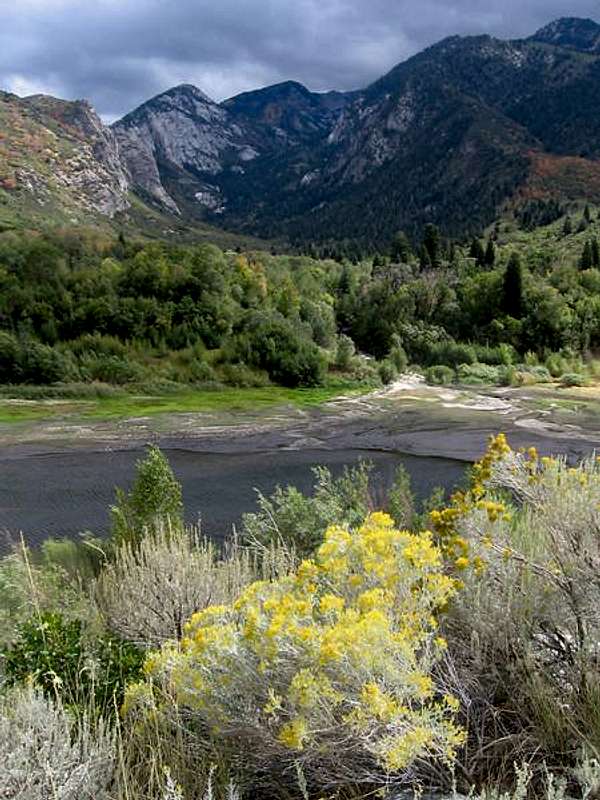
![Bells Canyon and Lower Bells Reservoir]() Bells Canyon as it looked at the start of our trip
Bells Canyon as it looked at the start of our tripThere has been a big gaping hole in my Wasatch wanderings, between Lone Peak and the Pfeifferhorn: a scenically unique and intriguing wilderness where I have never ventured, and this area contains one of the two hardest obstacles remaining in my recently renewed quest to complete all the Wasatch 11,000-foot peaks (the other bear being Sunrise Peak). And since my fitness right now was good, having finally gotten mostly past some knee issues and a broken wrist that have plagued the last couple of years, and with my successes this year buoying my confidence, I decided I couldn't wait clear until next year to climb North and South Thunder Mountain.
The plan was to spend two nights in Bells Canyon near the upper reservoir and give myself an entire day to do a loop over North and South Thunder and explore the area, possibly bagging other smaller peaks such as Upper Bells. Three friends were on board: two coworkers plus my wife's classmate Duane.
As the time approached, however, the forecast for the Thunder Mountain area was for highs in the 40s, a 90% chance of steady rain on summit day, with that turning to snow for the final night with freezing temperatures. My two coworkers bailed (mostly for other reasons than weather) leaving just me and Duane. I thought we still had a reasonable chance of summitting, since the chances of lightning were low (this was no transient summer thunderstorm), and rain was okay by me as long as the visibility didn't become too poor for routefinding (which I was willing to gamble on).
The day of the departure I got a large blood blister covering most of the ball of my foot while participating barefoot in an office volleyball tournament right before ditching work early. Bad start for a backpacking trip, I thought. At the trailhead I decided to puncture it, cut it off, and bandage it to prevent further rubbing.
Day 1: The First Delay
![Stopping to appreciate the beauty of the stream before crossing it]() Stopping to enjoy the stream's beauty before crossing it
Stopping to enjoy the stream's beauty before crossing it![Bells Canyon stream near where we camped]() the stream near where we camped
the stream near where we campedDeparting the Wasatch Boulevard trailhead (~5100 ft elevation) at 3 pm, we made what we thought was reasonably good time for the first few miles, and although we lost the trail a couple of times and did some bushwhacking and scrambling across streams, our biggest delays were for refilling water, eating, and taking photos, not routefinding. We thought based on the mileage to the upper reservoir that we could halve our speed and still reach it by sunset (7:30). At 7:00, we reached the flats near where the trail curves southward into the upper canyon. The map showed about one mile remaining, which we thought we could almost certainly do in a half hour. But there was a good campsite here (about 7900 ft), and the trail steepened; Duane expressed aversion to the idea of carrying our packs down that section, so we stayed there.
Upper Bells Reservoir
![Bells Cleaver from Thunder Bowl]() Our intermediate destination: Bells Cleaver's shoulder for passage into Thunder Bowl
Our intermediate destination: Bells Cleaver's shoulder for passage into Thunder BowlWe awoke to clear skies on Saturday, to my pleasant surprise, and should have started early because of not reaching the upper reservoir the night before, but we were still under the delusion (not having been in Bells Canyon before) that we were less than an hour away from it and how could we go wrong since we had all day? So we didn't depart until about 8:40. Indeed we made reasonable progress at first, but the trail becomes difficult to follow in this section. If it's not a pile of avalanche debris or a cliff band (which can at least be fun to climb through) or thickly vegetated gully to bushwhack through, it is simply the trail suddenly disappearing for no apparent reason: sometimes going a bit farther and/or looking around reveals another segment, but often not, and whereas some parts have an abundance of cairns detailing a route that would be obvious anyway, others with no obvious route have no cairns or ambiguously, inconsistently, or incorrectly placed ones. We knew roughly which direction we were aiming for, were not averse to scrambling or bushwhacking instead of fruitlessly deliberating over where "the" trail was, and thought we did a pretty good job of using "a" trail where possible, but it nevertheless took us two hours to reach the upper reservoir, which was only about a mile away from camp as the crow flies.
From the dam we could not see the slopes we planned to take to reach the notch on the ridge below Bells Cleaver, so we went the long (west) way around the lake to scope it out, discovering a straightforward zig-zag of three ramps leading through the cliff bands to the notch. However, our expectation was for the "trail" to stay near the lake, and since the trail branched ad hoc such that we never knew where the most efficient path lay, we kept attempting to stay left (east) only to get cliffed out and have to head back west and up. It appeared from our limited viewpoint that one could go around the cliffs to the slopes farther south and descend to the lake, but the cliffs followed us up, so finally we scrambled down through them. Since we didn't know of reliable water for the rest of the route we stopped at the lake to fill up and eat something. By the time we had gotten around the lake to our first ramp, we were already three hours from camp, and it was becoming cloudy.
Summit Fever vs. The Mountain
![Bells Canyon wall above a hanging meadow]() the wall of one of the nice hanging meadows above the upper reservoir
the wall of one of the nice hanging meadows above the upper reservoir![west face of North Thunder]() North Thunder's west face seen from our notch by Bells Cleaver
North Thunder's west face seen from our notch by Bells Cleaver![wall of visibility loss in Thunder Bowl]() a wall of visibility loss in Thunder Bowl
a wall of visibility loss in Thunder Bowl![upper Bells Reservoir from near the dam]() upper Bells Reservoir from the dam
upper Bells Reservoir from the damThe route to the notch was straightforward but not fast, because the boulders are large; snow is going to make this much faster when I try again early next season. At the notch we saw our first good view of North Thunder Mountain. Though not very prominent, it was impressive, and appeared more rugged than we expected; the gentle section at the top is pretty well-guarded by some cliff band or another. I had in mind
Joseph Bullough's
west face route, but from our vantage point we could not determine the feasibility of gaining the summit ridge at the notch mentioned; it appeared (probably deceptively) quite vertical. Duane preferred heading to upper Thunder Bowl and gaining the ridge between the North and South summits, a longer but less steep route. I on the other hand noticed that there appeared to be a ramp leading up above the cliff bands under the summit towards the south ridge, an extension of the slopes in the main gully that forms the west face route. I was game for either way, though, and we started towards Duane's route, but deteriorating weather and the tedium of boulder-negotiating (I can't say "hopping") convinced me that for speed's sake we should abandon that and go my steeper way. So we did, with the rain becoming more steady.
Starting at the meadow and pond under North Thunder, at about 2 pm, Duane began advocating that we turn back, citing decreasing visibility, dropping temperatures, and the fact that we had a long way back to go which was not going to go much faster on the way down because of the terrain, which also was going to just get slipperier. Furthermore, we didn't want to have to routefind down from the reservoir to camp in the dark, headlamps notwithstanding. At first he'd say he was "60/40" in favor of turning back; a hundred vertical feet more and it was 75/25, and maybe a third of the way up the face he'd reached 90/10. I didn't want to blow him off; he was not chickening out, indeed he is a more experienced mountaineer than I am and his points were sound and I knew it. I just didn't feel defeated yet. My argument was that yes, the worst thing would be to have to routefind/bushwhack in the dark, but we had set a hard turnaround time of 3 pm and it was still only 2:30. Yes, it was just going to get colder and wetter, but that was true whether we turned back now or 15 minutes later. Yes, we are tired, but we are almost there! But around this time, suddenly thick clouds engulfed Lone Peak behind us and began rapidly moving towards us, like some monster swallowing everything in its path. I was simultaneously intrigued and almost frightened by the sight, enjoying the sensation of awe and respect for the mountain's mood swings. At this point visibility above my elevation level (about 10,500 ft) went to almost nil and Duane, 50 feet below me, could barely see me. I decided this was an acceptable reason to turn back, since we still weren't certain of our route to the ridge and didn't want to get cliffed out in this whiteout.
Suddenly I was tired. I didn't realize how much I was propelling myself more on willpower and summit fever than real stamina. As it got wetter we discovered that even soaking wet, the granite in this area, which is quite unpolished, is still quite grippy--more so even than a lot of dry rock I have scrambled on. After much boulder-hopping and then bushwhacking from trail segment to trail segment and getting so wet that even my just-treated boots were giving in, we made it back to camp with daylight to spare for cooking and attempting to dry off. I was looking forward to changing into some dry layers I'd brought, but when I had stripped them off on the trail that morning I had been too lazy to put them in my dry bag, and they had gotten soaked from having only my pack to protect them. I set up a clothesline of sorts in my tent but by morning the only thing that had dried was my rain pants which were not even hanging up. If only I had brought my similarly-constructed rain jacket instead of my ski shell (which I did because it was warmer), then I'd still have a dry shell to wear on the way down. I did have dry shirts left, but luckily we got more graupel than rain that morning so I did not have to choose between getting wet from the coat versus the rain. We lazed around camp for a while, left at 10:40, and arrived at the trailhead a bit before 1 pm.
![Bells Canyon and Lower Bells Reservoir]() A beautiful look back at Bells Canyon from the bottom, the last day that year that Thunder Mountain would be snow-free
A beautiful look back at Bells Canyon from the bottom, the last day that year that Thunder Mountain would be snow-free


Comments
Post a Comment