A hike to Maggies South Peak, Lake Tahoe
![Descending a slab to Azure Lake]() Descending a slab to Azure Lake
Descending a slab to Azure Lake![Pat and Cedar at Azure Lake]() Pat and Cedar at Azure Lake
Pat and Cedar at Azure Lake![Lake Tahoe and Cascade Lake from Maggies South Peak]() Lake Tahoe and Cascade Lake from Maggies South Peak
Lake Tahoe and Cascade Lake from Maggies South Peak
Drove up Saturday night July 21 and spent the night camped north of Squaw Valley in the Tahoe National Forest. Sunday morning I made the short trip into Tahoe City on the north shore of Lake Tahoe to meet up with Cedar and Pat, both long time residents. We piled into Pats car and drove down the west shore to the very popular Emerald Bay area to hike
Maggies Peaks. It was a beautiful summer day, Highway 89 was loaded with motorists and the lake was packed out with people engaged in all manner of recreational activities.
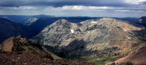
We were lucky to find a parking place at the Bayview Trailhead. The hike up was on a good trail with views through the forest down to Emerald Bay and Lake Tahoe. At the saddle the rugged granite of Phipps Peak, Peak 9,195' and Jakes Peak rose across the canyon above Eagle Lake to the north. We took a snack break and then proceeded up the easy slope to Maggies South Peak, (8,699'), the highest of the two. The spectacular views included Lake Tahoe, Emerald Bay, Cascade Lake and Fallen Leaf Lake below. To the southeast was the south shore and South Lake Tahoe with
Monument Peak and the
Freel Peak massif of the
Carson Range rising up to 10,800' above. The rest of the Carson Range stretched north along the east shore hemming in Lake Tahoe all the way to
Mt. Rose. The top of
Mt. Tallac was visible to the south and the north end of the Crystal Range could be seen to the west.
Cedar and Pat wanted to avoid the crowded trail back and add some adventure to the return trip. They convinced me to take the sketchy trail that descended to Azure Lake and Cascade Creek around the south side of Maggies South Peak back to the trailhead. The further we got the more I wished I had not taken them up on the offer. It added about 1 1/2 hours, a mile or so to the hike and was a constant mix of route finding, boulder hopping and swinging over downed trees most of the way. I was grumbling under my breath. "What is the point here!". But to seasoned locals like Pat and Cedar if was a refreshing diversion from the tourist route! At least there was beautiful Azure Lake along the way. Thank god I was with folks who knew the jumbled route back. In any case it was a good conditioner.
Down to Carson Pass
![Red Lake near Carson Pass]() Red Lake and Hawkins Peak
Red Lake and Hawkins Peak![Emerald Bay at dusk]() Emerald Bay at dusk
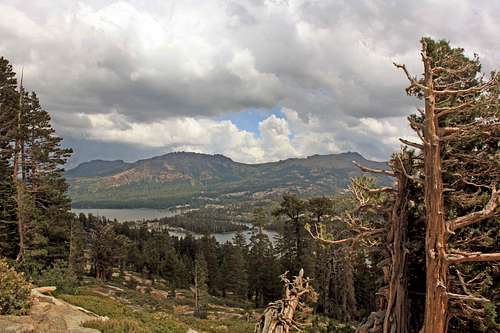
Emerald Bay at duskI was pretty tired and had a bit of a headache when we got back in the late afternoon. Pat is a walking encylopedia of the Tahoe region and like Cedar a long time experienced rambler of the whole Sierra Nevada. He graciously let my take a shower at his place and I thanked him for the hospitality. The weather report was for thunderstorms on monday afternoon. Cedar had to work that day so I bid her farewell and began the 40 mile drive south to Hope Valley east of Carson Pass. Having had only some tea, a Cliff Bar, a piece of mild cheddar cheese and a few nuts all day I had to eat something. I decided to steam up some potatoes and broccoli and eat it on the way to save time. It was a job packing the bites down, I still had little appetite but needed to eat to get grounded and help me get to sleep. At the junction with 89 and 88 I crossed the road and drove a short distance on a forest road to turn in for the night. It was 10 pm. I was awoken a 4 am with the sound of rain on the roof of the van. It quickly turned to hail. The brief squall only lasted about 5 minutes but didn't bode well for the morning. I wondered what the day would bring with such unstable weather already afoot.
Carson Pass to East Sister and back
![South from East Sister]() Heavy skies over the Mokelumne River canyon from East Sister
Heavy skies over the Mokelumne River canyon from East Sister![Red Lake Peak from the north]() Red Lake Peak
Red Lake Peak![Sunrise from Hope Valley]() Hope Valley at dawn
Hope Valley at dawn![Northwest pano from East Sister]() Northwest from East Sister
Northwest from East Sister
Up at 7 am. As I drove out to the west side of Hope Valley I could see plenty of rugged dark clouds all around but the peaks to the west around Carson Pass looked fairly clear. I stopped to make coffee. Over to the east beyond open meadows the sky above the dark silhouettes of
Pickett and
Hawkins Peak was endowed with Divine rays shooting into the heavens! At least if I got stormed out I would come away with a few good shots.
When I got to Carson Pass at 7:30 only a few cars were in the lot. Still it looked pretty good to go for a while at least so I packed up and headed down the trail towards the
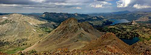
Round Top area. I figured if the weather got really iffy I would take the quick side trip up and settle for
Elephants Back (9,585') about a mile in off to the left. Having done the monarch of the area, Round Top (10,381') twice in the past I wanted to do
The Sisters (10,153') the lesser peaks just to the west of Round Top on the ridge.
The weather still looked fairly good so I decided to press on past Elephants Back to Lake Winnemucca. The scenery for photography couldn't have been better. Early morning light was striking the peaks, a profusion of flowers covered the area and the sky was a play of light and cloud!
As I got to the slope leading up to the peaks the weather still looked good enough to give it a go. Nevertheless with such huge chunks of darkness floating by it was never a certainty. I could get stormed down at any time.
The slope was easy enough but I spent considerable time gazing down at my feet while stopping for deep breaths due to lack of acclimation.
Happy to make the summit unscathed I relaxed a while and took a wealth of photos with the sky awash in thunderheads especially to the north around Tahoe.
On the way back the trail to Lake Winnemucca had filled out with hikers. I passed several nice people on the return and ended up hiking a short distance to the trailhead with a few ladies from Placerville who gave me an extra poncho as a sudden squall of rain/hail hit briefly.
It was around noon and the parking lot was packed out with cars as hikers took their chances even as the weather continued to worsen.
The dreaded orange diamonds
![Over Silver Lake to Thunder Mtn. and Thimble Peak]() Silver Lake on the way back
Silver Lake on the way back![Elephants Back, Round Top and The Sisters from Caples Lake]() Elephants Back, Round Top and The Sisters from Caples Lake
Elephants Back, Round Top and The Sisters from Caples Lake![Menacing orange diamond]() Menacing orange diamond
Menacing orange diamond
I was ready to drive home. It was monday, a regular work day for the boys at Caltrans and I knew before hand that delays were in store on Hwy 88 back to the Bay Area.
The report was something like: "One way controlled traffic at 'various locations'. Motorists are subject to delays of up to ten minutes west of Pinegrove due to tree trimming."
It was cool enough at the pass but as I drove down through the forested west side of the range temperatures rose dramatically. I stopped for a snack and took a brief nap before the long 5 hour haul back to Marin County.
Sure enough less than a quarter mile past Pinegrove there they were, the dreaded menacing orange diamonds!
The first one always says "road work ahead". The seconds has is an icon of a man holding a flag and the third says "be prepared to stop". The final vision halting all forward progress is the Caltrans guy in the middle of the road holding up a stop sign on a poll.
It had to be in the 90's and I certainly didn't fancy sitting around sweating out 10 minute delays over and over but...
The guy with the flag was nowhere to be found! The trucks and the trimmings were on the side of the road as we breezed through the first work zone.
But not so fast! There were more orange diamonds waiting up ahead. Again we breezed through. A total of at least 8 work zones each proceeded by the loatheful signs yielded a total of less than 40 seconds (at one location) of delay!
Caltrans turned out to be a paper tiger on this day!
Cruising down busy Hwy. 99 in the Central Valley I'm looking foward to a pizza at my favorite place in Manteca only a few minutes away. Then I see smoke down the road and just like that all lanes are brought to a halt as firetrucks and patrol cars weave their way past us with sirens blasting. Luckily I was at an exit ramp and had a map. Within minutes I was around the jam up on side roads and on my way again, steaming pizza in hand.
Got home early evening to the cool foggy air of the bay area after what at first looked almost hopeless but turned out to be an excellent day in the mountains.
Comments
No comments posted yet.