
-
 62517 Hits
-
 93.1% Score
-
 41 Votes
|
|
Area/Range |
|---|---|
|
|
38.66340°N / 120.00195°W |
|
|
Hiking, Mountaineering, Bouldering, Scrambling, Skiing |
|
|
Spring, Summer, Fall, Winter |
|
|
10382 ft / 3164 m |
|
|
Overview
Straddling the Sierra Nevada crest between Carson and Ebbett’s Passes, the Mokelumne Wilderness is an exceptional tract of rugged mountains, lakes, plunging canyons, and explosively wildflower-strewn meadows. In short, it is everything that one expects from a Sierra wilderness. To most people the Sierra Nevada is associated with the stark granite landscape of the High Sierra, the soaring granite cliffs of the valleys and canyons, as well as domes, waterfalls, jagged summits and lakes. However, while the Mokelumne does feature many of these aesthetic hallmarks of the Sierra, its composition differs from the typical granite landscape that is archetypal of the range. Nonetheless, the Mokelumne is a sublime slice of mountain wilderness.The Mokelumne Wilderness encompasses a region exhibiting both volcanic and glacial activity. While granitic extrusions are common in parts of the wilderness, sedimentary and volcanic rock is also common. The monarch of the Mokelumne, Round Top Peak is the remains of a volcanic vent and is composed of hardened ash and lava. Other notable peaks exhibit volcanic features as well. In spite of their heated past, these peaks, as well as other parts of the wilderness exhibit the influence of glaciers. The numerous lakes that dot the wilderness reflect the presence of glaciers at some point in the past.
 Round Top
Climbing is not great in the area because of the composition of the rocks. Jeff Davis Peak provides the most interesting climbing possibilities. The majority of the recreational use of the Mokelumne Wilderness takes the form of hiking and backpacking. The numerous peaks can generally be summited with little, if any, technical effort. Consequently they are popular destinations for both day hikers and backpackers. The lakes also provide popular destinations.
Although the Mokelumne Wilderness sees a fair amount of visitation, it provides greater opportunities for solitude than the Desolation, its neighboring wilderness to the north. This is truer still when one travels beyond the popular Carson Pass Management Area.
History
Miwok and Washo Indians initially inhabited the Mokelumne Wilderness. In 1826 the famed mountain man Jedidiah Smith crossed the Sierras somewhere in this region. This was the first crossing of the Sierra Nevada by an American (or any other European). Smith had extensive firsts in California, including leading the first party overland to what would become the state, as well as the first traverse along the entire Pacific coast of what would become the United States. The Smith River and Jedidiah Smith Redwoods State Park are named after him in commemoration of this event. After crossing the Sierra near the Mokelumne Wilderness, he completed the first successful crossing of the Great Basin. Carson Pass as seen from the Mokelumne Wilderness
Kit Carson guided John C. Fremont across the Sierra Nevada in this region in 1844. Carson Pass, the Carson River, the Carson Range (that part of the Sierra in the state of Nevada), Carson City, and the Carson-Iceberg Wilderness all bear witness to this event.
A decade after the Gold Rush hit the rest of the Sierra in 1849, mining was pursued in the eastern end of the wilderness area. Once the mining operations petered out livestock ranging became the dominant use of the land.
The land that now comprises the Mokelumne Wilderness was originally included in the Stanislaus Forest Reserve, which was created in 1897. This was eventually split into the Stanislaus and Eldorado National Forests. The current wilderness also extends eastward into the Toiyabe National Forest.
Livestock grazing has been present since the 19th century and continues to the present. The Pacific, Gas, & Electric Company developed two small hydroelectric operations in the basin drained by Blue Creek sometime around the turn of the century. Blue Creek was dammed to form the Upper and Lower Blue Lakes. The lakes do not have hydroelectric power plants on them but they are used to retain water for hydroelectric plants further downstream during drier times of year.. In spite of these uses, the Mokelumne remained relatively untouched and was one of the first wildernesses created following the passage of the Wilderness Act in 1964.
Geography
The Mokelumne Wilderness currently encompasses 105,165 acres. Round Top, its highest peak, reaches a height of 10,382 ft. while the Salt Springs Reservoir in the extreme southwest corner is the lowest point at 3,960 ft. The Desolation Wilderness viewed from the Mokelumne Wilderness
Highways 88 and 4 embrace the area on the north and south respectively. The wilderness can be approximately divided into three general regions. The northern portion of the Mokelumne consists of a series of high peaks beginning with Round Top Peak and running southwest to Mokelumne Peak. This region is drained on the south side by Summit Creek, which separates the Round Top Peak area from another group of peaks topped by Deadwood Peak.
The canyon of the North Fork of the Mokelumne River dominates the southern partition of the wilderness. Lined with rugged cliffs, the canyon generally maintains a depth of around 3,000 ft. as the river flows southwest toward the Salt Springs Reservoir. While trails descend into the canyon, none follow its course and this area remains remote.
The third part of the wilderness is separated from the rest of the Mokelumne Wilderness by Forest Service road 9N83. This is an area of high volcanic peaks that form a basin containing numerous lakes. The lake basin itself is outside the wilderness boundary and is accessed by a maintained road. While the road approaches from the west, the basin is actually drained east through the wilderness by Pleasant Valley Creek.
The area around Round Top receives heavy use because of its spectacular scenery and close proximity to Highway 88. Consequently, the area is under tighter control by the Forest Service and is administered as the Carson Pass Management Area.
The Pacific Crest Trail passes through the eastern part of the Mokelumne. It is accessible from the Wet Meadows, Blue Lakes and Carson Pass trailheads as well as from the trailhead at Ebbetts Pass southeast of the Reynolds Peak area.
Peaks
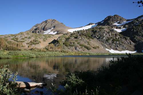
 Round Top and the Sisters
Round Top(10,382 ft.):
Dominating the Carson Pass skyline, Round Top is the monarch of the Mokelumne Wilderness. In terms of scenic qualities, height and bulk, Round Top reigns in solitary isolation over the northern reaches of the wilderness. Its summit is reached with relative ease from the Carson Pass area.
The Sisters(10,153 & 10,045 ft.):
The Sisters are twin peaks protruding from the ridgeline that extends westward from Round Top. They are particularly attractive from Round Top Lake, where they loom above the lake and numerous possible campsites.
Raymond Peak(10,014 ft.):
The highest summit in the eastern section of the Mokelumne Wilderness, Raymond Peak is volcanic in nature. Lying beneath the summit, Raymond Lake is a popular destination for hikers. The Pacific Crest Trail is routed near the summit.
 Deadwood Peak
Deadwood Peak (9,846 ft.):
The third highest peak in the wilderness, Deadwood Peak receives less visitation than the rest of the high peaks in the Mokelumne. It is visible from the Blue Lakes area and the trail to Grouse Lake passes south of it, but it remains fairly obscure. Three subordinate peaks above 9,000 ft. surround Deadwood.
Melissa Coray Peak (9,763 ft.):
This summit is situated on the western boundary of the Mokelumne wilderness. It rises above the 4th of July Lake area. It is just outside the Carson Pass Management Area.
Reynolds Peak(9, 679 ft.):
Reynolds Peak is the second highest peak in the eastern Mokelumne. Like Raymond Peak, its neighbor to the north, Reynolds Peak is associated with the Ebbetts Pass area. The quickest way to the summit is to catch the Pacific Crest Trail at Ebbetts Pass and head north.
Elephants Back (9,585 Ft.)
The Elephants Back is a high peak composed of volcanic rock a short distance northeast from Round Top. Its summit forms the eastern boundary of the Carson Pass Management Area.
Markleeville Peak(9,415 ft.):
Sharing its name with the community to the northeast, Markleeville Peak lies is the northeastern region of the Mokelumne Wilderness. It is volcanic in origin like all the other peaks in the eastern Mokelumne.
Mokelumne Peak(9,334 ft.):
Towering in isolation above the western stretch of the Wilderness, Mokelumne Peak is the highest summit along the Mokelumne River canyon. The enticingly named Mokelumne Tetons rise out of the canyon south of the peak.
Jeff Davis Peak (9,065 ft.):
A volcanic spire located in the eastern stretch of the wilderness. It is the highpoint between Markleeville and Raymond Peaks.
Lakes
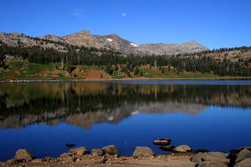
The Mokelumne Wilderness is home to several fantastic lakes. Like most mountain wildernesses, the lakes are popular hiking and backpacking destinations.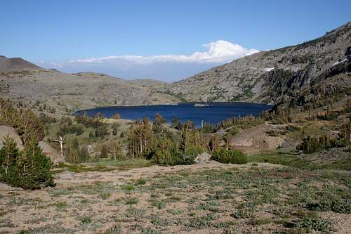 Winnemucca Lake
Winnemucca Lake
Perhaps the most popular lake in the wilderness, it is large and lined with towering cliffs on its south shore. The lake has great views of Round Top. It is easily accessed from the Carson area and is located in the Carson Pass Management Area.
Round Top Lake
Round Top Lake maintains equal claim on the qualities possessed by Winnemucca Lake. Although it is not as large, it has fantastic views of the Sisters in addition to Round Top. It is located in the Carson Pass Management Area.
4th of July Lake
This lake is a popular hiking and backpacking destination. It is situated in an impressive cirque on the backside of Round Top and is accessible from the Carson Pass and Blue Lakes areas. 4th of July Lake is also found in the Carson Pass Management Area.
Emigrant Lake
Situated beneath a rocky cliff, Emigrant Lake is a popular hiking destination. It is accessed from Caples Lake.
Frog Lake
The Pacific Crest Trail passes beside this lake. It is only a short hike along the PCT to reach this lake from the Carson Pass trailhead.
 Granite Lake
Granite Lake
Granite Lake is easily accessed from the Blue Lakes area. As one might guess from its name, the lake sits in an attractive granite bowl, unlike most of the lakes in the Mokelumne Wilderness. Granite Lake is a popular day hiking destination.
Grouse Lake
Located beneath Deadwood Peak, Grouse Lake is the terminus of the trail that leads to Granite Lake. Far fewer people make the push beyond Granite Lake, leaving Grouse relatively empty.
Raymond Lake
While there are a few small lakes to the northwest, Raymond Lake is the only lake of consequence in the eastern unit of the Mokelumne Wilderness. The lake is located near Raymond Peak and is accessible off the Pacific Crest Trail from the Wet Meadows Trailhead.
Trailheads
29 trailheads serve the Mokelumne Wilderness. Most generally provide access to limited parts of the wilderness interior and traveling cross-country would be required from more extensive trips. While most of these trailheads almost guarantee isolation, the scenery is generally not the same caliber as the scenery accessed from more popular trailheads. This stands to reason, of course. This section is only intended to enumerate some of the more popular trailheads. The locations of the following trailheads beings in the northwest corner of the wilderness and continues clockwise, ending on the south side.Caples Lake
The Caples Lake trailhead provides access to Emigrant Lake. The trail initially follows the south shore of Caples Lake before turning south toward Emigrant Lake.
Lost Cabin
The most direct route to 4th of July and Round Top Lakes begins at this trailhead.
Woods Lake
This trailhead provides quick access to Winnemucca Lake. From the lake, trials split off, heading west to Round Top Lake and east to Frog Lake and Carson Pass.
Carson Pass
The Pacific Crest Trail intersects Highway 88 at the Carson Pass trailhead. Hikers will use the trailhead to depart on the short hike to Frog Lake.
Forestdale Divide
A trail departing this trailhead is routed along the canyon wall above Summit City Creek. It leads to 4th of July Lake. The Pacific Crest Trail is accessed from this trailhead as well.
Evergreen
The trail leaving from here parallels the one leaving from Forestdale Divide, except that it is routed along the shores of Summit City Creek.
 Round Top from the Grouse Lake trailhead
Grouse Lake
Grouse and Granite Lakes are the destinations of the trail leaving this trailhead. Deadwood Peak is also accessed from here.
Blue Lakes
The Blue Lakes does not provide direct access to the Mokelumne Wilderness, but it does provide road access to the Pacific Crest Trail. The PCT enters the wilderness at either the Forestdale Divide trailhead or the Wet Meadows trailhead.
Wet Meadows
Raymond Peak and Raymond Lake are accessed from this point. This is the first trailhead reached along the Pacific Crest Trail after leaving Ebbetts Pass.
Ebbetts Pass
The Pacific Crest Trail crosses Highway 4 at the Ebbetts Pass trailhead. From here one can either head north towards Reynolds Peak in the Mokelumne Wilderness or travel south into the Carson-Iceberg Wilderness.
Lake Valley
Located just north of Lake Alpine on Highway 4, this trailhead provides direct access into the Mokelumne River canyon.
Tanglefoot
The quickest route to the top of Mokelumne Peak begins here.
Camping
Campgrounds are available at most of the trailheads. The Woods Lake campground is particularly popular since two trails leading into the Carson Pass Management Area begin at the campground. In addition to a Forest Service campground by the Blue Lakes, Pacific Gas & Electric Company also operates some nice campgrounds next to the lakes. Camping is permitted at trailheads if there is no official campground.Backcountry camping should be 100 feet away from lakes. Try to use campsites left by previous backpackers. These are generally in the bestlocations already, so it is an easy effort to make. Wilderness permits are required.
 Round Top, the Sisters and Round Top Lake in the Carson Pass Management Area
Carson Pass Management Area
Camping in the Carson Pass Management Area has special restrictions. Only the established campsites at Winnemucca, Round Top and 4th of July Lake are open to camping. There are 3 sites at Winnemucca Lake, six sites at Round Top Lake and six sites at 4th of July Lake. There is no camping at Frog Lake. During the period between the Friday before Memorial Day weekend to Labor Day the duration of overnight stays at the lakes, per party, are limited to two nights at Winnemucca and Round Top Lakes and three days at 4th of July Lake.
Campfires are prohibited in the Carson Pass Management Area.
Red Tape
 Round Top from the eastern slope of Deadwood Peak
Normal wilderness rules and ethics apply. Permits are required for any overnight travel in the wilderness. No permits are required for day hiking. Only one permit is necessary for a group but it is only good for one trip. Some trailheads, notably the Carson Pass trailhead, require small fees.
Campfires are prohibited above 8,000 ft.
Carson Pass Management Area
Special rules and regulations are required for camping in the Carson Pass Management Area. These are enumerated in the Camping section.
Eldorado National Forest
28620 Silver Dr.
Pioneer, CA 95666
(209) 295-4251
Humboldt-Toiyabe National Forest
1536 So. Carson St.
Carson City, NV 89701
(775) 882-2766
Markleeville Guard Station
Markleeville, CA 96120
(530) 694-2911
Stanislaus National Forest
5519 Highway 4, P.O. Box 500
Hathaway Pines, CA 95233
(209) 795-1381
Getting There
The Mokelumne Wilderness is accessible from Highway 99 by either Highway 88 or Highway 4. The preponderance of entry into the wilderness is via a route stemming off of Highway 88. Highway 89 also connects the Carson Pass area with Lake Tahoe and Interstate 80. Blue Lakes Road, which heads south off of Highway 88 a few miles east of Carson Pass connects to several popular trailheads, including Grouse Lake and Wet Meadows.When To Go
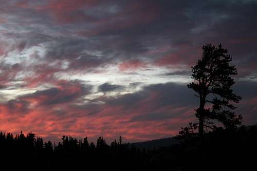 Mokelumne sunset
The Mokelumne Wilderness is a year-round wilderness area. Of course, June through October is certainly the most popular period for entry into the area, once the snows have melted and the trails are passable. The climate is typically Sierran, with warm, generally dry days with the occasional thunderstorm to punctuate the week. Winter, provides a different wilderness experience for those intrepid enough to attempt entry. Snow shoeing and wilderness skiing are also popular activities in the Mokelumne Wilderness.
External Links
-Forest Service site for Mokelumne Wilderness-Carson Pass Management Area