


-
 4518 Hits
-
 77.48% Score
-
 8 Votes
|
|
Route |
|---|---|
|
|
45.89700°N / 7.23965°E |
|
|
Mountaineering, Skiing |
|
|
Summer |
|
|
A long day |
|
|
AD |
|
|
Class 3 |
|
|
9 |
|
|
II |
|
|
Note
|
La montagna chiama i suoi figli, ed essi rispondono fedelmente al suo appello… Osvaldo Cardellina, Diario alpinistico, 1964-65 Page texts: @ OsvaldoCardellina "Osva", passed away on May 2, 2022. Page owners: Christian Cardellina e Osvaldo Cardellina. Any updates from September 12, 2022: Antonio Giani, page administrator, friend and climbing companion. Testi della pagina: @ OsvaldoCardellina "Osva", scomparso il 2 maggio 2022. Proprietari pagina: Christian Cardellina e Osvaldo Cardellina. Eventuali aggiornamenti dal 12 settembre 2022: Antonio Giani, amministratore della pagina, amico e compagno di salite. |
Occulted & Mixed Overview
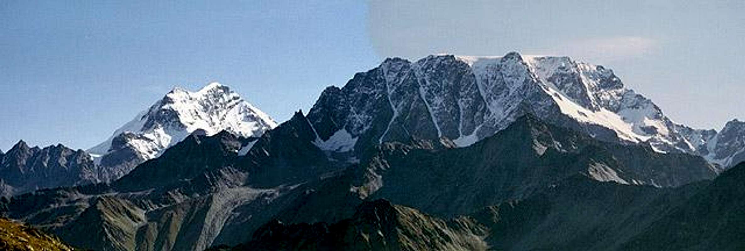
Mountain quite complex, is formed by five sides, two of which are addressed to each of the two nations. We are interested in talking about the one facing Southwest over the consecutive Vallons of Menouve e Mollines and the Municipalities of Allein and Etroubles. Two ridges contain this large sector: the South-southwest Ridge who leaves off a long spur that reaches its end on the Mont Saron, above Allein. The margin is bordered by the North rather long ridge but less indented Western Ridge that reaches the Gran San Bernardo Hill (2.469m), above the Vallons of Proz (Switzerland), Mollines e del Gran San Bernardo. But it is certainly the second, ie Etroubles, who is more identified with the Mont Velan and its Southwestern Slope. We had already spoken of the wide Wall Southwest of Mont Velan (3.734m) in "My List" of May 10, 2010 and precisely in B) - GREAT Combins / MOUNT VELAN - LEFT SIDE Second Part, but in a context that was precisely the entire sector of the Pennine Alps as to analyze all that was between the Col Ferret and Valpelline until the Dent d'Hérens and Les Gr. and Pt. Murailles, as well as the internal areas to the Valley of Baltea. A very large area to visit and where the wall of Velan, as described in detail, was lost in the ocean of information. Even here in this Route, as in the previous on the rocky Wall E-SE, you want instead only focus on the same, especially with regard to its early history and returning, for those who want to know more, to complete the job, but that is beyond the target that you want to search here.
This side, so good view looking from the Great Saint Bernard, in fact remains "secluded and almost grumpy" to be seen and noticed from the valley floor.
But his vision does not remain unnoticed for an eye that looks up from the vicinity of Etroubles. His is a story that began back in September 1872 when H.J. and Walter Leaf along with the Guide Swiss Hans Baumann and that of Valtournanche, Daniel Bich, run through during the crossing of the Mont Velan, downhill the most rocky slope Southwest. Down through a steep gully and dangerous (in those days probably entirely covered by snow) by a narrow carving located between the Quota 3.708 meters to the North and that of 3.672 meters, just before the junction with the long Ridge Northeast down to the Valsorey Pass (3.107m) and the Southern Crest which reaches the Saddle and the Faceballa Pass (3.280m, 3.239m). In doing so down to arrive on Glacier suspended Mont Velan and from this in the Valley of Molline, continuation of that of Menouve on the Italian side. After the West Ridge from Hannibal Pass (2.992m) is the first time someone looks around here that, already in the remote 1779 Canon Murith and Hunter Genoud had "peeked" from the top of the same after leaving the Wall W-NW. This path will not be covered until July 1902, when the Turin Agostino Ferrari and Edoardo Garrone Guide Caesar Meynet Valtournanche climb this slope uphill, but with a twist diagonally rightmost leading them directly to Quota 3.672 meters. But the side was already uphill the previous year when in September the Piedmont Guido Cibrario and Franco Viale, accompanied by Guides Swiss Daniel and Omer Balley, opened a via in the opposite (North) past the large socket base Glacier du Mont Velan, crossing the same and ending on the Southern Face of the Quota 3.678 meters, located immediately to the Northwest of the Dôme or Ice Cap of the Velan. Nicely to note that Father Daniel had 76, yes just seventy-six! Other Generations !! All streets still very dangerous and exposed to falling stones or even landslides (by personal experience) that, after some initial interest, rightly they have fallen by the wayside, such as those of Walls West and E-SE. In the middle of these two paths we are a direct descent and completely glacial by Gino Buscaini with his wife Silvia Metzeltin October 31th, 1970, uphill path taken by Osvaldo Cardellina and Renzo Botti with a more direct line to left 6th September 1973 overcoming exit the large cornice Summit. The descent was through the South-southwestern Wall via a variant even more in the South and almost parallel to Via 1902 with large landslide near the end of a forty metres from the stony baseline. The first was made a quite difficult "mixed via", with lonely ascent in 27th July 1997, on a sector more Northwest of Quota 3.708 meters, down the Ridge to the S-SW to the below Faceballa Saddle and nearby Pass (3.280m, 3.239m).
Then we go back for a moment on these old-growth and glorious footsteps, marking a particularly historic Mont Velan..
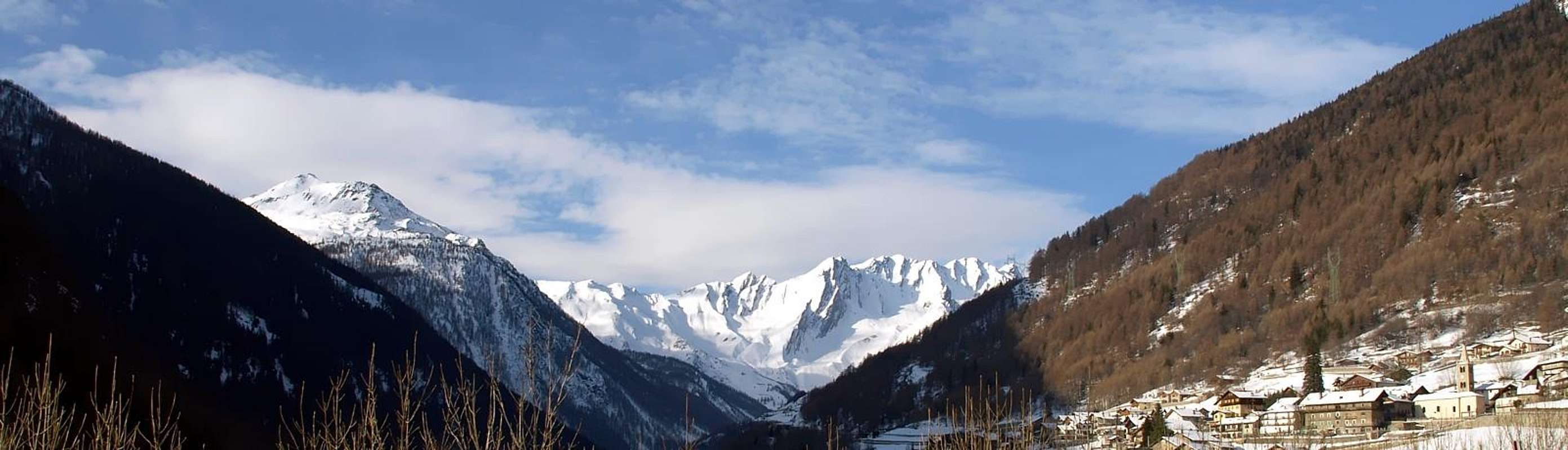
Il Mont Velan o V'lan si trova nelle Alpi Pennine, subito a Sudovest del Gruppo dei Grands Combins e quindi posizionato sul confine tra Italia e Svizzera.
Montagna alquanto complessa, é formata da cinque versanti dei quali due sono rivolti ad ognuna delle due nazioni. Ci interessa parlare di quello rivolto a Sudovest sopra i due Valloni consecutivi di Menouve e Mollines ed ai Comuni di Allein ed Etroubles. Due creste contengono quest'ampio settore: la Cresta Sud-sudovest che lascia scendere un frastagliato contrafforte raggiungente al suo termine il Mont Saron (2.681 m) sopra Allein; il margine Settentrionale invece é delimitato dall'altrettanto lunga ma meno accidentata cresta di frontiera che arriva insino al Colle del Gran San Bernardo (2.469 m), sopra i Valloni di Proz, Mollines e del Gran San Bernardo. Ma é sicuramente il secondo comune, cioé Etroubles, che s'identifica maggiormente con il Mont Velan o V'lan (3.734 m) ed il suo Versante Sudoccidentale che eternamente lo sovrasta. Avevamo già parlato della grande Parete Sudovest in "My List" del 10 Maggio 2010 e precisamente in B)- GREAT COMBINS / MOUNT VELAN - LEFT SIDE Second Part, ma in un contesto trattante appunto l'intero settore delle Alpi Pennine tale da analizzarne tutto ciò che fosse compreso tra il Col Ferret e la Valpelline sino alla Dent d'Hérens e Les Grandes e Petites Murailles, nonché le zone più interne fino alla Valle Centrale della Dora Baltea. Un'area molto vasta da visitare e dove la parete del Velan, per quanto dettagliatamente descritta, si perdeva nell'oceano dell'informazioni. Anche qui in questa Route, come nella precedente concernente la rocciosa Parete Est-sudest, si vuole invece soltanto mettere a fuoco la medesima, soprattutto per quanto riguarda la sua storia iniziale e quindi vecchia rinviando, per chi ne voglia più sapere, a quel lavoro completo ma esulante dall'obiettivo qui cercato.
![]()
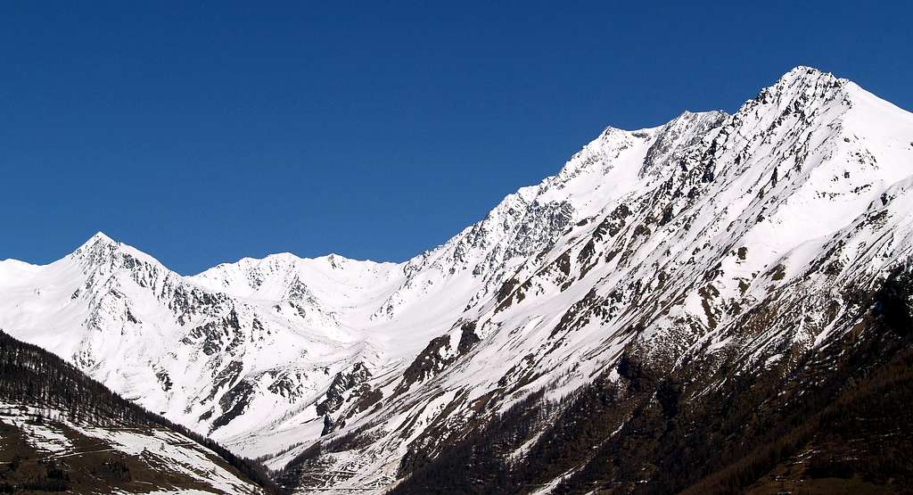
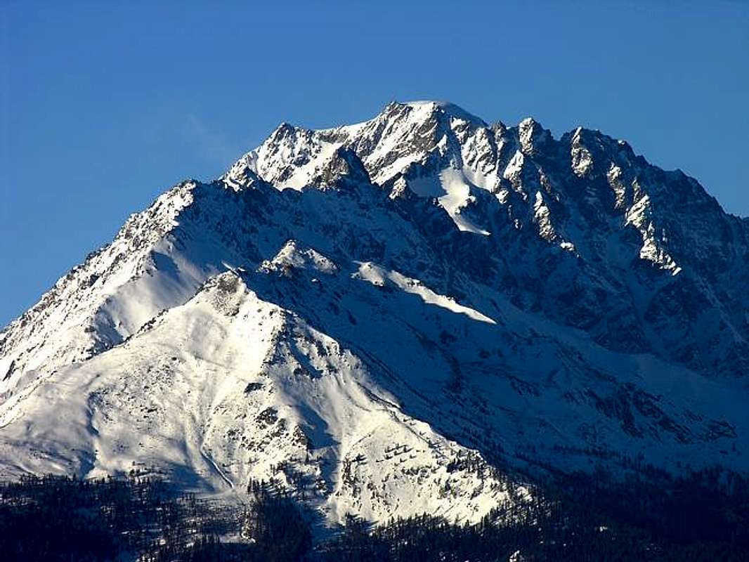
Velan above Proz (left) and Molline(s) Vallons with West Wall shadowed & Southwestern sunny, by Erik Pizzolotto
Questo versante, sì ben in vista guardando dal Colle del Gr. San Bernardo, in realtà rimane "appartato e quasi scontroso" d'esser visto e notato dal fondovalle. Ma la sua vista non rimane inosservata per un occhio attento che alza lo sguardo dalle vicinanze d'Etroubles. La sua é una storia che inizia nel lontano Settembre 1872 quando H.J. e Walter Leaf insieme alle Guida svizzera Hans Baumann ed a quella di Valtournanche, Daniele Bich, percorrono, durante la traversata del Mont Velan, in discesa la parte più rocciosa del Versante Sudovest. Scendono tramite un ripido e pericoloso canalone (a quei tempi molto probabilmente interamente ricoperto da neve) da uno stretto intaglio collocato tra la Quota 3.708 metri a Nord e quella 3.672 metri, poco prima della congiunzione con la lunga Cresta Nordest che scende verso il Colle di Valsorey (3.107 m) e la Cresta Sud, che s'indirizza alla Sella e Colle di Faceballa (3.280 m, 3.239 m). Così facendo scendono sul Ghiacciaio sospeso del Mont Velan e da questo nel Vallone di Molline, continuazione di quello di Menouve sul versante italiano. Dopo la Cresta Ovest dal Colle di Annibale (2.992 m) é la prima volta che qualcuno si affaccia da queste parti che, già nel remoto 1779, Murith e Genoud avevano "sbirciato" dalla parte alta della medesima dopo essere usciti dalla Parete O-NO. Questa via non sarà più percorsa fino al Luglio del 1902, quando i torinesi Agostino Ferrari ed Edoardo Garrone con la Guida Cesare Meynet di Valtournanche scalano questo versante in salita, ma con una variante in diagonale più a destra che li conduce direttamente alla Quota 3.672 metri. Ma il versante era già stato percorso in salita l'anno precedente quando nel mese di Settembre i piemontesi Guido Cibrario e Franco Viale, accompagnati dalle Guide svizzere Daniel ed Omer Balley, aprono una via nel settore opposto (Nord) superando il grande zoccolo di base del Glacier du Mont Velan, attraversando il medesimo e terminando sulla Faccia Meridionale della Quota 3.678 metri, collocata subito a Nordovest del Dôme o Calotta del Velan. Simpaticamente da annotare che Papà Daniel aveva 76 anni, sì proprio settantasei! Altre Generazioni!! Tutte vie comunque molto pericolose ed esposte a cadute di pietre se non addirittura frane (per personale esperienza) che, dopo un certo interesse iniziale, giustamente son cadute nel dimenticatoio, come quelle delle Pareti Ovest ed E-SE. In mezzo a queste due vie troviamo una discesa diretta e completamente glaciale da parte di Gino Buscaini con la moglie Silvia Metzeltin il 31 Ottbre 1970, percorso ripreso in salita da Osvaldo Cardellina e Renzo Botti con linea ancora più diretta a sinistra il 6 Settembre 1973 superando all'uscita il grande cornicione sommitale. La discesa avvenne tramite la Parete Sud-sudovest tramite una variante ancora più a Meridione e pressocché parallela alla Via 1902 con gran frana quasi al termine ad una quarantina di metri dalla pietraia basale. Il primo ha realizzato da solo il 27 Luglio 1997 una via abbastanza difficile di "misto" sulla Parete Nordovest della Quota 3.708 metri con discesa per la Cresta S-SO alla Sella e vicino Colle di Faceballa.
Torniamo quindi per un momento sopra queste vetuste nonché gloriose orme, che segnano un momento particolarmente storico del Mont Velan.
![]()
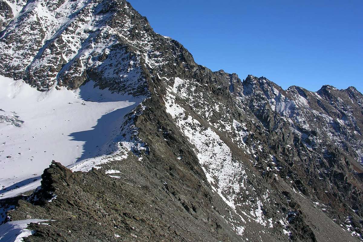
Mont Velan or V'lan over Mollines Vallon & from Great Saint Bernard Pass with Western view, by Antonio
BY PLANE:
![]()
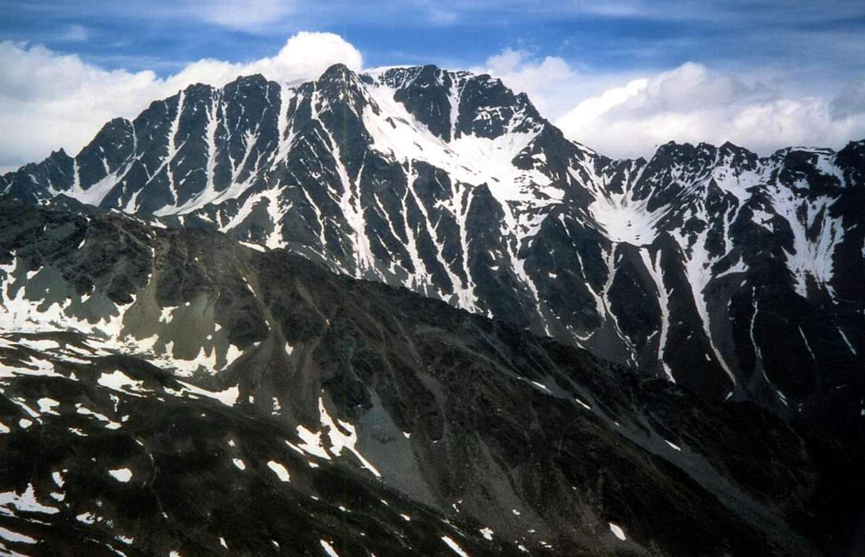
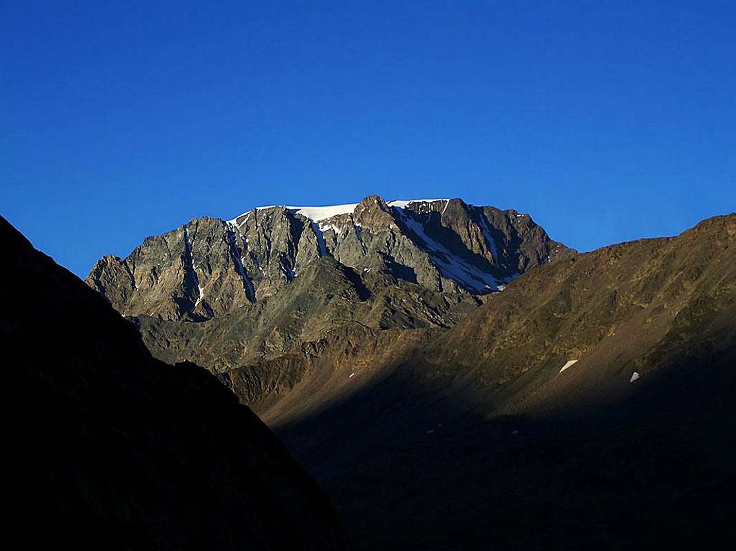
Mont Saron towards Velan, by Antonio
Montagna alquanto complessa, é formata da cinque versanti dei quali due sono rivolti ad ognuna delle due nazioni. Ci interessa parlare di quello rivolto a Sudovest sopra i due Valloni consecutivi di Menouve e Mollines ed ai Comuni di Allein ed Etroubles. Due creste contengono quest'ampio settore: la Cresta Sud-sudovest che lascia scendere un frastagliato contrafforte raggiungente al suo termine il Mont Saron (2.681 m) sopra Allein; il margine Settentrionale invece é delimitato dall'altrettanto lunga ma meno accidentata cresta di frontiera che arriva insino al Colle del Gran San Bernardo (2.469 m), sopra i Valloni di Proz, Mollines e del Gran San Bernardo. Ma é sicuramente il secondo comune, cioé Etroubles, che s'identifica maggiormente con il Mont Velan o V'lan (3.734 m) ed il suo Versante Sudoccidentale che eternamente lo sovrasta. Avevamo già parlato della grande Parete Sudovest in "My List" del 10 Maggio 2010 e precisamente in B)- GREAT COMBINS / MOUNT VELAN - LEFT SIDE Second Part, ma in un contesto trattante appunto l'intero settore delle Alpi Pennine tale da analizzarne tutto ciò che fosse compreso tra il Col Ferret e la Valpelline sino alla Dent d'Hérens e Les Grandes e Petites Murailles, nonché le zone più interne fino alla Valle Centrale della Dora Baltea. Un'area molto vasta da visitare e dove la parete del Velan, per quanto dettagliatamente descritta, si perdeva nell'oceano dell'informazioni. Anche qui in questa Route, come nella precedente concernente la rocciosa Parete Est-sudest, si vuole invece soltanto mettere a fuoco la medesima, soprattutto per quanto riguarda la sua storia iniziale e quindi vecchia rinviando, per chi ne voglia più sapere, a quel lavoro completo ma esulante dall'obiettivo qui cercato.

Questo versante, sì ben in vista guardando dal Colle del Gr. San Bernardo, in realtà rimane "appartato e quasi scontroso" d'esser visto e notato dal fondovalle. Ma la sua vista non rimane inosservata per un occhio attento che alza lo sguardo dalle vicinanze d'Etroubles. La sua é una storia che inizia nel lontano Settembre 1872 quando H.J. e Walter Leaf insieme alle Guida svizzera Hans Baumann ed a quella di Valtournanche, Daniele Bich, percorrono, durante la traversata del Mont Velan, in discesa la parte più rocciosa del Versante Sudovest. Scendono tramite un ripido e pericoloso canalone (a quei tempi molto probabilmente interamente ricoperto da neve) da uno stretto intaglio collocato tra la Quota 3.708 metri a Nord e quella 3.672 metri, poco prima della congiunzione con la lunga Cresta Nordest che scende verso il Colle di Valsorey (3.107 m) e la Cresta Sud, che s'indirizza alla Sella e Colle di Faceballa (3.280 m, 3.239 m). Così facendo scendono sul Ghiacciaio sospeso del Mont Velan e da questo nel Vallone di Molline, continuazione di quello di Menouve sul versante italiano. Dopo la Cresta Ovest dal Colle di Annibale (2.992 m) é la prima volta che qualcuno si affaccia da queste parti che, già nel remoto 1779, Murith e Genoud avevano "sbirciato" dalla parte alta della medesima dopo essere usciti dalla Parete O-NO. Questa via non sarà più percorsa fino al Luglio del 1902, quando i torinesi Agostino Ferrari ed Edoardo Garrone con la Guida Cesare Meynet di Valtournanche scalano questo versante in salita, ma con una variante in diagonale più a destra che li conduce direttamente alla Quota 3.672 metri. Ma il versante era già stato percorso in salita l'anno precedente quando nel mese di Settembre i piemontesi Guido Cibrario e Franco Viale, accompagnati dalle Guide svizzere Daniel ed Omer Balley, aprono una via nel settore opposto (Nord) superando il grande zoccolo di base del Glacier du Mont Velan, attraversando il medesimo e terminando sulla Faccia Meridionale della Quota 3.678 metri, collocata subito a Nordovest del Dôme o Calotta del Velan. Simpaticamente da annotare che Papà Daniel aveva 76 anni, sì proprio settantasei! Altre Generazioni!! Tutte vie comunque molto pericolose ed esposte a cadute di pietre se non addirittura frane (per personale esperienza) che, dopo un certo interesse iniziale, giustamente son cadute nel dimenticatoio, come quelle delle Pareti Ovest ed E-SE. In mezzo a queste due vie troviamo una discesa diretta e completamente glaciale da parte di Gino Buscaini con la moglie Silvia Metzeltin il 31 Ottbre 1970, percorso ripreso in salita da Osvaldo Cardellina e Renzo Botti con linea ancora più diretta a sinistra il 6 Settembre 1973 superando all'uscita il grande cornicione sommitale. La discesa avvenne tramite la Parete Sud-sudovest tramite una variante ancora più a Meridione e pressocché parallela alla Via 1902 con gran frana quasi al termine ad una quarantina di metri dalla pietraia basale. Il primo ha realizzato da solo il 27 Luglio 1997 una via abbastanza difficile di "misto" sulla Parete Nordovest della Quota 3.708 metri con discesa per la Cresta S-SO alla Sella e vicino Colle di Faceballa.
Torniamo quindi per un momento sopra queste vetuste nonché gloriose orme, che segnano un momento particolarmente storico del Mont Velan.
Getting There
BY CAR:- From TORINO, MILANO, etc: Motorway A5. Exit at IVREA or Quincinetto (PIEDMONT).
- From IVREA Town: before in West to Aosta, after in Northwest to Gignod, Etroubles, Saint-Oyen, Saint Rhémy en Bosses and in North to Allein Municipalities.
- From Courmayeur Resort: before in East to Aosta, after in Northwest to Gignod and in North to Allain Municipalities.
From Aosta Town to Allein and Etroubles and Allein or Allain Commons at the beginning of Great Saint Bernard Valley
From Aosta City towards Variney Fraction and Gignod Commune (988m) with Great Saint Bernard SS.27 up to the alternative 1.074 meters, just before Condemine Hamlet (1.137m). Before crossing North the Artanavaz Torrent or Buthier de Bosses after in the Northwest towards Etroubles and Allein Municipalities.![]()
Etroubles Common, by Antonio - From FRANCE: through the Mont Blanc Tunnel to Entrèves-crossroads to Vény/Ferret Valleys - Courmayeur. By Little Saint Bernard Pass, closed since November until half May to La Thuile Valley - Pré Saint Didier - Courmayeur. It is not necessary to take Motorway A5: you can drive on SS.26, in the direction of AOSTA - IVREA - TURIN.
BY PLANE:
- Aeroporto "Corrado Gex" Saint Christophe (Aosta).
Routes Description
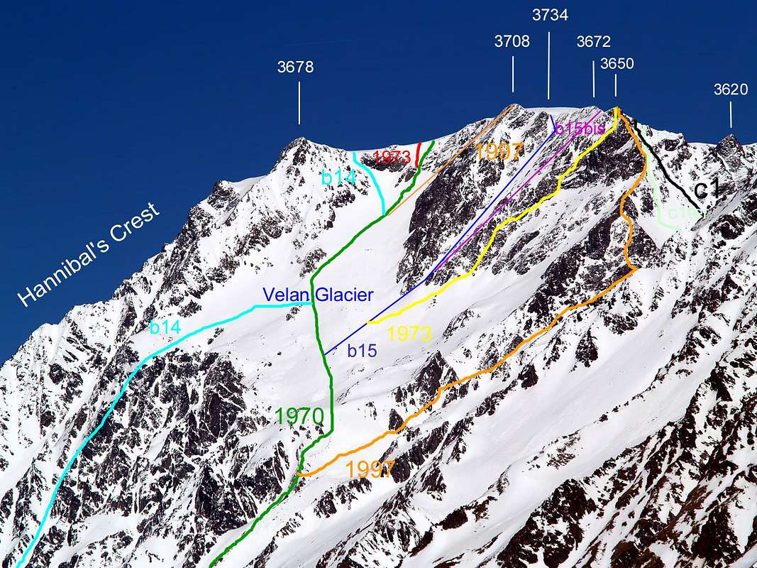
We give a little hint to the technical description and average travel times for each of the eigth ways of the SW Side above Molline, also see the photo below.
In the list of the same is is preferred, according to a criteria "historic", follow a line of chronological time sequence and then to highlight the speech made in this Overview.
In the caption of the photo below you you will find instead a show topographic and orographic starting from the left (Hill of Hannibal and West Ridge) to reach the right margin (Saddle and Col Faceballa and S-SW Ridge). In the transition from one to the other are dotted with considerable accuracy the eight existing routes on the side with one clarification: the way b14 in azure in the lower part corresponds to that of 1901, while the upper part shows the current via Ski-Mountaineering, passing just to the right of the route on the Southern Wall of the Quota 3.678 meters, actually traveled by the group a rope Swiss Guides Balley father and son with Guido Cibrario and Franco Viale.
Diamo un piccolo accenno con la descrizione tecnica e gli orari medi di percorrenza per ognuna delle otto vie del Versante Sudovest sopra il Vallone di Molline.
Nell'elencazione delle stesse s'é preferito, seguendo criterio "storico", seguire una linea di successione temporale-cronologica per evidenziare il discorso effettuato in Overview. Nella didascalia della foto sottostante troverete invece un'esposizione topografica-orografica partendo dalla sinistra (Colle di Annibale e Cresta Ovest) per raggiungere il margine destro (Sella e Colle di Faceballa e Cresta S-SW). Nel passaggio dall'una all'altra vengono tratteggiati con buon margine di precisione gli otto itinerari esistenti sul versante con un'unica precisazione: la via b14 in azzurro corrisponde nella parte inferiore a quella del 1901, mentre la superiore indica l'attuale via di Sci-Alpinismo, passando subito sulla destra della via sulla Parete Sud della Quota 3.678 metri effettivamente percorsa dalla cordata delle Guide svizzere Balley padre e figlio con Guido Cibrario e Franco Viale.
![]()
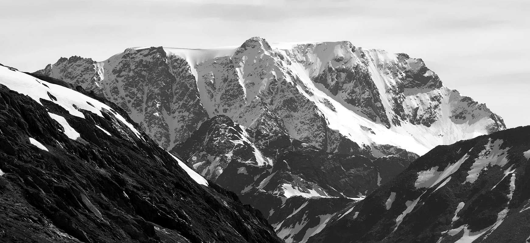
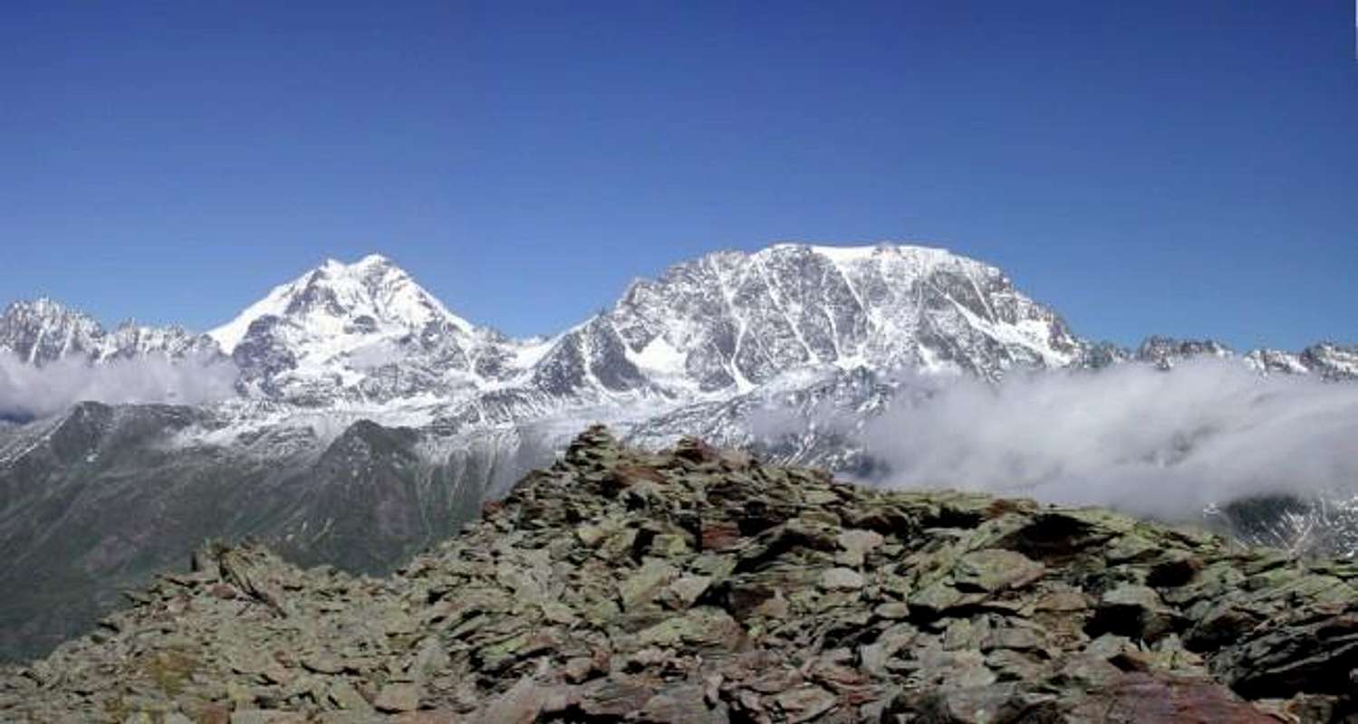
V'lan (3.734m) over Menouve/Mollines Vallons from Southwest, by Antonio, traced by Osw
"The Ways older"
2) - (September 04th, 1901): from the bivouac (in those days Montagne de Molline) leave on the right (East) the previous path towards the Saddle Faceballa; instead continue North on detrital valley floor aiming at the penultimate rocky channel (the last meeting ahead of the Aiguille du Déujener on West Ridge). After reaching the base at an altitude of 2.804 meters, climbing the same, often with the snowy route, quite easily until you reach the Glacier Mont Velan at an altitude of 3.270/80 meters in its Northern margin. This with almost 500 meters of altitude difference is already "an ascension in the ascension" and, crossing the glacier towards the Northeast, leading to a rocky spur that descends to the South-southwest from the Quota 3678 metres. The slope of that is from the right with a diagonal to the left until almost reaching the West Ridge to finally bend to the right, reaching the Summit (F+/PD-; 2h'00/2h'30 from base up to the Glacier du Mont Velan; PD-/PD+; 1h'30/2h'00 by the entrance on glacier; 5h'30/6h'30 bivouac; the ascent is not easy in the final on rocky rib; signed b14 in the low part, while in that upper corresponds at the current Ski-Mountaineering Itinerary that bypasses right or East). The original path, probably no more repeated, constitutes a "fall-back", as the first climbers leaned to the left along the rocky rib from trends rather regular. In Bull. C.A.I. XL, 1909, p. 114 and notes Agosino Ferrari and Guido Cibrario in RM 1901, p. 385). In fact the same claim to have left alongside a icy slide very steep: "The road became very bad, having had to travel for a while the edge of the ridge, with a steep slip side ...". That being on the left (West) are only rocky parts, it means that it is clear of the slope where he currently spends Via Ski-Mountaineering. This means that at that time the ice conditions were very different with more snow and its steepness. This also explains why the vast sector of the face between this via and the rocky downhill of 1872 has never been faced up to October 1970 (descent Buscaini-Metzeltin to power back in the Valleys of Molline/Menouve after covering a part of the Crest S-SW coming through the large Southern Couloir above the side of By Basin).
3) - (July 15th, 1902): It follows the wall "more open" just to the right of the previous route 1) -, but it is equally exposed to falling rocks especially in parts of the medium-low. The attack is similar to the previous route, while the climb is via routes between rocks very small parallel ridges alternating with narrow rocky gullies. Gradually moving away from the preceding couloir is reached Quota 3.672 meters almost at the end of the South Ridge from Faceballa Saddle or by the Col (F/F+; 1h'30 from the base; 3h'30/4h'00 from V'lan's Glacier 5h'00/6h'00 by bivouac; also this climb dangerous and exposed to falling rocks for identical reasons; signed in the picture as b15bis).
"The Ways Most Recent"
4) - (October 31th, 1970): directly to the glacial Slope Southwest. Having been carried out for the first time down this way we describe it in this way: from the Summit Ice Cap in Northwest to the edge of it until you reach the wide saddle between the Altitudes 3.678 and 3.708 meters in the Northwest and South. From this, avoiding the frame summit, descend to 100 meters around the very steep glacial slope (55/60°) and passing to the South of a plate and reddish boulder in a narrow and short groove, reaching the Glacier du Mont Velan (AD/PD+; 0h'45/1h'00 in descent up to the glacier. It is certainly the most direct route to take to the Val Molline and Menouve Vallon, although it requires a focus on the end frame; uphill 4h'30/5h'00 by bivouac, time varies greatly depending on the ice and the frame terminal; in the photo signed in red as 1970).
5) - (September 06th, 1973): in practice it is a variant even more direct but more dangerous than the previous route. Effected uphill and in day departing from Prailles above Etroubles follow the other routes up to the glacier. Then goes up directly passing on left (North) of a reddish rock, and ends left increasingly from the previous route with excess (55°/65°/70° and then also 80 degrees), and "cut" directed trim overhang also high 5/6 meters (step very delicate, not done at the time with the "piolet-traction"). Probably not always possible and to be avoided with the snow does not last (PD+/AD- for the first two pitches; MD+ for the last; 4h'30/5h'30 from bivouac; 6h'00/6h'30 Prailles; 4h'30 in the first by Prailles; in the photo above signed as 1973 in red). This route is probably somewhat changed in the last forty years; Indeed, an analysis from below, no longer notice the large frame summit that will become less effective shrinking to a small hem. This confirms the considerations made on lime Via 1901. To that end goes noticed how the glacial slope, already much changed between 1901 and 1970 (down Buscaini spouses), has undergone considerable change with the gradual withdrawal of the ice sheet; so in the next route described here is very likely to meet emerging rocks and covered with "verglass phenomena", where there was a uniform snowy slope.
6) - (July 27th, 1997): Climbs the Northwest Face of Quota 3.708 meters with a rise in the ground "mixed" not very long but delicate. As in the previous two routes up to where the glacier increases in steepness and under the rocky islet of reddish color; at this point turn right (South) reaching the base of a tiny rocky slope at the base of the Face (danger of falling rocks and ice). Discarding on the right the large triangle rocky, climb instead on the same small rocky appendix reaching the glacial slope above, which exceeds from right to left reaching the Summit of the Quota and then the Ice Cap (AD/AD+; 2h'00/2h'30 from base for the final 240/50 meters; 5h'00/5h'30 bivouac).
7) - (July 27th, 1997): further variant of the streets in 1872 and 1902, has been used with a descent even further south than the same, where the face turns a wall of rocks very Southwest routes over the final part of the Western branch of South-southwest Crest from the Hill and Saddle Faceballa. From Quota 3.672m down to short, reaching a shoulder at following Quota 3.630m; from this, abandoning the S-SW Crest, get off to the right (North) on the edge of a small triangular rocky wall. Passing three small rocky consecutive "bottlenecks", go down progressively to the right reaching the rocky cliff just South of Via 1902. Through this, a hundred metres high and perhaps seemingly repaired (the landslide in September 1973 came right over from the previous via, because the stones go always down in their uncontrolled rebounds for the shortest way and do not respect the diagonals drawn on a sketch), descend to the stony ground below and the outer fringe Southern of the Glacier du Mont Velan. This section does not give in to the call channel, but keep on the rocks of small ridges, a little more difficult (II°-) but certainly safer. It has similar characteristics of the two previous resulting equally and perhaps even more dangerous (terrible landslide in September 1973; F+; 1h'00/1h'15 down, in ascent probably 2h'00; not recommended at all; signed in orange as 1997)
8) - (August 31th, 1999): variant on a small pillar of the more Western Face of Quota 3708 meters with ascent in day from Quaye Alp (1.600m~) at the beggining of Menouve Valley: up to the Arvus Pasture (1.983m) and followed slope on grassy promontory below the Molline Alp (current or from 2005) Molline 's Bivouac (2.415m); with descent through the Western Ridge (Italian/Swiss border) up to the Colle di Annibale also "Hannibal 's Pass": (2.992m) and through the Molline/Menouve Vallons. Always with the same routes of ITALIAN SKI-MOUNTAINEERING ROUTE, "Direct Route 1970" and "Supergirect Route 1973", Northwest Face of Quota 3.708 meters, all on Southwestern Face above the Molline Vallon, and therefore starting from "Molline 's Pasture (2.424m) below the Velan Glacier or from the just adjacent (open since 2005) Molline 's Shelter (2.415m). In very short time to continue Northeast along the detrital valley floor from the altitude of 2.440 meters up to the basal horographic left (even this generally without snow, but with debris, some small rocks and sparce boulders); to overcome the same entirely and directly up to the reach before a small detrital basin <em(about 2.900 meters, preceding the glacier), under the Saddle (3.280m) and the Pass of Faceballa (3.239m, very caution, because it is often covered by grassy "ollina", very much slippery); after to traverse North reaching the Southern or right margin of Velan Glacier in altitude of about 3.100 meters. From this point cross the same with semi circular route; before with a little inclination left up to the point 3.323 meters at the base of a Western small pillar on more Western Face of Quota 3.708 meters. Before briefly continue doubling left (Nortgheast) the same, after by a short diagonal line of climbing reaching, just above the suspended and below the hanging Velan Glacier, the lateral rocky base of the same, that progressively decline into the glacier. This point go up through a serie, not easy, of reddish-brown slabs using a small but in evidence initial gully leading to a crescent-shaped ledge turned upwards (usually covered in snow); with less inclination but identical difficulties, progressively flexing before to the left or North after right or South, you reach the previous route that climbs from the small and often icy Northwest Wall. From PD- to PD+/AD-/AD with one step of AD+ (rocky steps of I°+/II°-/II°/II°+/III°- and one of III°; height of 430 meters and length of about 470 meters)); 5h.15'/5h.30' from the base of the moraine below the Faceballa 's Saddle or from Molline 's Bivouac; from the ban of transit into Menouve lower Valley at Quaye Alps (1.614m); 8h.30'/9h.00.
![]()
So the Face is more rocky, by Gabriele Roth aka Gabriele
"Le Vecchie Vie"
Nell'elencazione delle stesse s'é preferito, seguendo criterio "storico", seguire una linea di successione temporale-cronologica per evidenziare il discorso effettuato in Overview. Nella didascalia della foto sottostante troverete invece un'esposizione topografica-orografica partendo dalla sinistra (Colle di Annibale e Cresta Ovest) per raggiungere il margine destro (Sella e Colle di Faceballa e Cresta S-SW). Nel passaggio dall'una all'altra vengono tratteggiati con buon margine di precisione gli otto itinerari esistenti sul versante con un'unica precisazione: la via b14 in azzurro corrisponde nella parte inferiore a quella del 1901, mentre la superiore indica l'attuale via di Sci-Alpinismo, passando subito sulla destra della via sulla Parete Sud della Quota 3.678 metri effettivamente percorsa dalla cordata delle Guide svizzere Balley padre e figlio con Guido Cibrario e Franco Viale.
"The Ways older"
1) - (September 03th, 1872):
from the South margin of the Glacier du M. Velan climb the West Gully of the cliff between the Units 3.708, 3.672 meters: from the base at an altitude of 3.323 meters, with just path "tilted" right to exit, after about 380 meters to Slotted between the two, at the western edge of the Summit Ice Cap (F+/PD-; 1h'30 by the base; 3h'30/4h'00 from the entrance on glacier; 5h'00/6h'00 bivouac; climb dangerous and exposed to falling rocks from the overlying rocky ridge; signed b15).2) - (September 04th, 1901): from the bivouac (in those days Montagne de Molline) leave on the right (East) the previous path towards the Saddle Faceballa; instead continue North on detrital valley floor aiming at the penultimate rocky channel (the last meeting ahead of the Aiguille du Déujener on West Ridge). After reaching the base at an altitude of 2.804 meters, climbing the same, often with the snowy route, quite easily until you reach the Glacier Mont Velan at an altitude of 3.270/80 meters in its Northern margin. This with almost 500 meters of altitude difference is already "an ascension in the ascension" and, crossing the glacier towards the Northeast, leading to a rocky spur that descends to the South-southwest from the Quota 3678 metres. The slope of that is from the right with a diagonal to the left until almost reaching the West Ridge to finally bend to the right, reaching the Summit (F+/PD-; 2h'00/2h'30 from base up to the Glacier du Mont Velan; PD-/PD+; 1h'30/2h'00 by the entrance on glacier; 5h'30/6h'30 bivouac; the ascent is not easy in the final on rocky rib; signed b14 in the low part, while in that upper corresponds at the current Ski-Mountaineering Itinerary that bypasses right or East). The original path, probably no more repeated, constitutes a "fall-back", as the first climbers leaned to the left along the rocky rib from trends rather regular. In Bull. C.A.I. XL, 1909, p. 114 and notes Agosino Ferrari and Guido Cibrario in RM 1901, p. 385). In fact the same claim to have left alongside a icy slide very steep: "The road became very bad, having had to travel for a while the edge of the ridge, with a steep slip side ...". That being on the left (West) are only rocky parts, it means that it is clear of the slope where he currently spends Via Ski-Mountaineering. This means that at that time the ice conditions were very different with more snow and its steepness. This also explains why the vast sector of the face between this via and the rocky downhill of 1872 has never been faced up to October 1970 (descent Buscaini-Metzeltin to power back in the Valleys of Molline/Menouve after covering a part of the Crest S-SW coming through the large Southern Couloir above the side of By Basin).
3) - (July 15th, 1902): It follows the wall "more open" just to the right of the previous route 1) -, but it is equally exposed to falling rocks especially in parts of the medium-low. The attack is similar to the previous route, while the climb is via routes between rocks very small parallel ridges alternating with narrow rocky gullies. Gradually moving away from the preceding couloir is reached Quota 3.672 meters almost at the end of the South Ridge from Faceballa Saddle or by the Col (F/F+; 1h'30 from the base; 3h'30/4h'00 from V'lan's Glacier 5h'00/6h'00 by bivouac; also this climb dangerous and exposed to falling rocks for identical reasons; signed in the picture as b15bis).
"The Ways Most Recent"
4) - (October 31th, 1970): directly to the glacial Slope Southwest. Having been carried out for the first time down this way we describe it in this way: from the Summit Ice Cap in Northwest to the edge of it until you reach the wide saddle between the Altitudes 3.678 and 3.708 meters in the Northwest and South. From this, avoiding the frame summit, descend to 100 meters around the very steep glacial slope (55/60°) and passing to the South of a plate and reddish boulder in a narrow and short groove, reaching the Glacier du Mont Velan (AD/PD+; 0h'45/1h'00 in descent up to the glacier. It is certainly the most direct route to take to the Val Molline and Menouve Vallon, although it requires a focus on the end frame; uphill 4h'30/5h'00 by bivouac, time varies greatly depending on the ice and the frame terminal; in the photo signed in red as 1970).
5) - (September 06th, 1973): in practice it is a variant even more direct but more dangerous than the previous route. Effected uphill and in day departing from Prailles above Etroubles follow the other routes up to the glacier. Then goes up directly passing on left (North) of a reddish rock, and ends left increasingly from the previous route with excess (55°/65°/70° and then also 80 degrees), and "cut" directed trim overhang also high 5/6 meters (step very delicate, not done at the time with the "piolet-traction"). Probably not always possible and to be avoided with the snow does not last (PD+/AD- for the first two pitches; MD+ for the last; 4h'30/5h'30 from bivouac; 6h'00/6h'30 Prailles; 4h'30 in the first by Prailles; in the photo above signed as 1973 in red). This route is probably somewhat changed in the last forty years; Indeed, an analysis from below, no longer notice the large frame summit that will become less effective shrinking to a small hem. This confirms the considerations made on lime Via 1901. To that end goes noticed how the glacial slope, already much changed between 1901 and 1970 (down Buscaini spouses), has undergone considerable change with the gradual withdrawal of the ice sheet; so in the next route described here is very likely to meet emerging rocks and covered with "verglass phenomena", where there was a uniform snowy slope.
6) - (July 27th, 1997): Climbs the Northwest Face of Quota 3.708 meters with a rise in the ground "mixed" not very long but delicate. As in the previous two routes up to where the glacier increases in steepness and under the rocky islet of reddish color; at this point turn right (South) reaching the base of a tiny rocky slope at the base of the Face (danger of falling rocks and ice). Discarding on the right the large triangle rocky, climb instead on the same small rocky appendix reaching the glacial slope above, which exceeds from right to left reaching the Summit of the Quota and then the Ice Cap (AD/AD+; 2h'00/2h'30 from base for the final 240/50 meters; 5h'00/5h'30 bivouac).
7) - (July 27th, 1997): further variant of the streets in 1872 and 1902, has been used with a descent even further south than the same, where the face turns a wall of rocks very Southwest routes over the final part of the Western branch of South-southwest Crest from the Hill and Saddle Faceballa. From Quota 3.672m down to short, reaching a shoulder at following Quota 3.630m; from this, abandoning the S-SW Crest, get off to the right (North) on the edge of a small triangular rocky wall. Passing three small rocky consecutive "bottlenecks", go down progressively to the right reaching the rocky cliff just South of Via 1902. Through this, a hundred metres high and perhaps seemingly repaired (the landslide in September 1973 came right over from the previous via, because the stones go always down in their uncontrolled rebounds for the shortest way and do not respect the diagonals drawn on a sketch), descend to the stony ground below and the outer fringe Southern of the Glacier du Mont Velan. This section does not give in to the call channel, but keep on the rocks of small ridges, a little more difficult (II°-) but certainly safer. It has similar characteristics of the two previous resulting equally and perhaps even more dangerous (terrible landslide in September 1973; F+; 1h'00/1h'15 down, in ascent probably 2h'00; not recommended at all; signed in orange as 1997)
8) - (August 31th, 1999): variant on a small pillar of the more Western Face of Quota 3708 meters with ascent in day from Quaye Alp (1.600m~) at the beggining of Menouve Valley: up to the Arvus Pasture (1.983m) and followed slope on grassy promontory below the Molline Alp (current or from 2005) Molline 's Bivouac (2.415m); with descent through the Western Ridge (Italian/Swiss border) up to the Colle di Annibale also "Hannibal 's Pass": (2.992m) and through the Molline/Menouve Vallons. Always with the same routes of ITALIAN SKI-MOUNTAINEERING ROUTE, "Direct Route 1970" and "Supergirect Route 1973", Northwest Face of Quota 3.708 meters, all on Southwestern Face above the Molline Vallon, and therefore starting from "Molline 's Pasture (2.424m) below the Velan Glacier or from the just adjacent (open since 2005) Molline 's Shelter (2.415m). In very short time to continue Northeast along the detrital valley floor from the altitude of 2.440 meters up to the basal horographic left (even this generally without snow, but with debris, some small rocks and sparce boulders); to overcome the same entirely and directly up to the reach before a small detrital basin <em(about 2.900 meters, preceding the glacier), under the Saddle (3.280m) and the Pass of Faceballa (3.239m, very caution, because it is often covered by grassy "ollina", very much slippery); after to traverse North reaching the Southern or right margin of Velan Glacier in altitude of about 3.100 meters. From this point cross the same with semi circular route; before with a little inclination left up to the point 3.323 meters at the base of a Western small pillar on more Western Face of Quota 3.708 meters. Before briefly continue doubling left (Nortgheast) the same, after by a short diagonal line of climbing reaching, just above the suspended and below the hanging Velan Glacier, the lateral rocky base of the same, that progressively decline into the glacier. This point go up through a serie, not easy, of reddish-brown slabs using a small but in evidence initial gully leading to a crescent-shaped ledge turned upwards (usually covered in snow); with less inclination but identical difficulties, progressively flexing before to the left or North after right or South, you reach the previous route that climbs from the small and often icy Northwest Wall. From PD- to PD+/AD-/AD with one step of AD+ (rocky steps of I°+/II°-/II°/II°+/III°- and one of III°; height of 430 meters and length of about 470 meters)); 5h.15'/5h.30' from the base of the moraine below the Faceballa 's Saddle or from Molline 's Bivouac; from the ban of transit into Menouve lower Valley at Quaye Alps (1.614m); 8h.30'/9h.00.
"Le Vecchie Vie"
1) - (3 Settembre 1872): dal margine Meridionale del ghiacciaio si sale il Canalone Ovest della parete compresa tra le Quote 3.708, 3.672 metri: partendo dalla base a quota 3.323 metri, con percorso appena "inclinato" a destra si esce, dopo circa 380 metri all'intaglio tra le due, presso il margine Occidentale della Calotta (F+/PD-; 1h'30 dalla base; 3h'30/4h'00 dall'ingresso nel ghiacciaio; 5h'00/6h'00 dal bivacco; ascensione pericolosa ed esposta alla caduta di pietre dal soprastante costolone roccioso; siglata b15).
2) - (4 Settembre 1901): dal bivacco (a quei tempi Montagne de Molline) lasciare sulla destra (Est) la via per la Sella ed il Colle di Faceballa; invece proseguire a Settentrione sul detritico fondo del vallone mirando al penultimo dei canali rocciosi a Nord dello sperone roccioso che si affonda più in basso (l'ultimo sale a monte dell'Aig. du Déujener sulla Cresta Ovest). Raggiunta la base a quota 2.804 metri, salire il medesimo canalone, spesso con il fondo innevato, abbastanza facilmente fino a raggiungere il Ghiacciaio del Mont Velan a quota 3.270/80 metri circa nel suo margine Settentrionale. Questa con quasi 500 metri di dislivello risulta già "un'ascensione nell'ascensione" e, attraversando verso Nordest il ghiacciaio, conduce ad una costola rocciosa che scende verso Sud-sudovest dalla Quota 3.678 metri. La salita della medesima avviene dalla destra con un diagonale verso sinistra sin a quasi raggiungere la Cresta Ovest per infine piegare a destra raggiungendo la Cima (F+/PD-; 2h'00/2h'30 dalla base al ghiacciaio; PD-/PD+; 1h'30/2h'00 dall'ingresso nel ghiacciaio; 5h'30/6h'30 dal bivacco; ascensione non semplice nel finale sulla costola rocciosa; siglata b14 nella parte inferiore mentre in quella alta la stessa corrisponde alla Via Sci-Alpinistica, aggirata la costola a destra od Est). La via originale, probabilmente non più ripetuta, costituisce un "ripiego", poiché i primi salitori s'appoggiarono sulla sinistra percorrendo la costola rocciosa dall'andamento piuttosto regolare. In Boll. C.A.I. XL, 1909, pag. 114 e note di Agosino Ferrari e Guido Cibrario in RM 1901, pag. 385). Infatti gli stessi affermano d'avere lasciato a fianco uno scivolo molto ripido ghiacciato: "la strada si fece assai cattiva, avendo dovuto percorrere per un tratto il filo di cresta, con un ripido sdrucciolo di fianco ...". Essendo che sulla sinistra (Ovest) esistono soltanto parti rocciose, giocoforza significa che trattasi del pendio ove attualmente passa la Via di Sci-Alpinismo; questo a significare che a quel tempo le condizioni glaciali fossero molto diverse con maggiore innevamento e relativa ripidezza. Ciò spiega anche perché il vasto settore di parete tra questa via e quella rocciosa in discesa del 1872 non sia mai stato affrontato fino ad Ottobre 1970 (discesa Buscaini-Metzeltin per poter rientrare nel Valloni di Molline e Menouve dopo aver percorso una parte della Cresta S-SO uscendo tramite il gran Canalone Meridionale sopra il Bacino di By).
3) - (15 Luglio 1902): segue la parete "più aperta" subito alla destra dell'itinerario 1) -, ma é altrettanto esposta alla caduta di pietre soprattutto nelle parti medio-basse. L'attacco é similare alla precedente via 1) -, mentre la salita avviene tramite rocce alquanto rotte tra crestine parallele alternate a canalini rocciosi. Allontanandosi progressivamente dal precedente canalone si raggiunge la Quota 3.672 metri praticamente al termine della Cresta Sud dalla Sella di Faceballa (F/F+; 1h'30 dalla base; 3h'30/4h'00 dal ghiacciaio; 5h'00/6h'00 dal bivacco; anche questa ascensione pericolosa ed esposta alla caduta di pietre per identici motivi; siglata nella foto come b15bis).
"Le Vie più Recenti"
4) - (31 ottobre 1970): direttamente per il pendio glaciale Sudovest. Essendo stata effettuata per la prima volta in discesa questa via la descriviamo in tale senso: dalla Calotta dirigersi a Nordovest fino al margine della medesima fino a raggiungere la larga sella posta tra le Quote 3.678 metri a Nordovest e 3.708 metri a Sud. Da questa, evitando la cornice sommitale, scendere per 100 metri circa il pendio molto ripido (55/60°) e, passando a Sud di un masso roccioso piatto e rossiccio in una strettoia-canalino, raggiungere il Glacier du Mont Velan (AD/PD+; 0h'45/1h'00 in discesa; costituisce sicuramente la via più diretta per scendere in Val Molline e Menouve, anche se richiede una particolare attenzione sulla cornice terminale; in salita calcolare 4h'30/5h'00 dal Bivacco di Molline, tempo molto variabile a seconda delle condizioni glaciali e della cornice terminale).
5) - (06 Settembre 1973): in pratica è una variante ancora più diretta ma più pericolosa della via precedente. Effettuata in salita ed in giornata con partenza dal Villaggetto di Prailles sopra Etroubles segue le altre vie fino al ghiacciaio; quindi sale direttamente passando sulla sinistra (Nord) del masso rossiccio (pericolo di caduta pietre) e conclude sempre più a sinistra rispetto alla precedente via con superamento (55°/65°/70° e poi anche 80°) e "taglio" diretto della cornice strapiombante ed alta anche 5/6 metri (passaggio molto delicato, effettuato all'epoca senza "piolet-traction" e con ramponi da misto). Probabilmente non sempre possibile e da evitare assolutamente con neve non dura (PD+/AD- per i primi due tiri di corda; MD+ per l'ultimo; 4h'30/5h'30 dal Bivacco di Molline; 6h'00/6h'30 da Prailles; 4h'30 nella prima salita in giornata da Prailles).
Questa via probabilmente é alquanto mutata in questi ultimi quaranta anni; infatti, da un'analisi dabbasso, non si nota più la grande cornice sommitale che s'é notevolmente ridotta riducendosi a modesta orlatura. Questo a conferma delle considerazioni effettuate a calce sulla Via del 1901. All'uopo và notato come il versante glaciale, già molto cambiato tra il 1901 ed il 1970 (discesa dei coniugi Buscaini), abbia subito notevoli trasformazioni col ritiro progressivo della coltre glaciale; così nella successiva via sulla Parete Nordovest della Quota 3.708 metri, sotto descritta, é molto probabile incontrare rocce emergenti nonché ricoperte da "verglass, laddove esisteva uniforme pendio innevato.
6) - (27 Luglio 1997): affronta la Parete Nordovest della Quota 3.708 metri con una salita in terreno "misto" non molto lunga ma delicata. Come nelle due vie precedenti fino a dove il ghiacciaio aumenta in ripidezza e sotto lo isolotto roccioso di colore rossiccio; a questo punto voltare a destra (Sud) raggiungendo la base di una minuscola appendice rocciosa alla base della Faccia (pericolo di caduta di pietre e ghiaccio). Scartando sulla destra il grande triangolo roccioso, salire invece sulla stessa raggiungendo il pendio glaciale soprastante, che si supera da destra a sinistra raggiungendo la Sommità e la Calotta (AD/AD+; 2h'00/2h'30 dalla base per i 240/50 metri finali; 5h'00/5h'30 dal bivacco).
7) - (27 Luglio 1997): ulteriore variante delle vie del 1872 e 1902, é stata utilizzata con discesa ancora più a Sud rispetto alle medesime, laddove la faccia rivolge una Parete Sudovest di rocce molto rotte sopra la parte finale del ramo più Occidentale della Cresta Sud-sudovest dal Colle e Sella di Faceballa. Dalla Quota 3.672 m scendere per breve raggiungendo una spalla presso la Quota 3.630 m; da questa, abbandonando la Cresta S-SO, scendere a destra (Nord) sul filo d'una piccola parete triangolare. Oltrepassando tre piccole "strozzature" consecutive, dirigersi progressivamente sempre verso destra raggiungendo il salto roccioso subito a Sud della Via 1902. Tramite questo, alto un centinaio di metri e forse apparentemente più riparato (la frana nel 1973 arrivò proprio sopra questo dalla precedente via, poiché le pietre scendono sempre ed incontrollate nei loro rimbalzi per la via più breve e non rispettano le diagonali tracciate sulla carta), scendere alla sottostante pietraia ed ai margini estremi Meridionali del Glacier du Mont Velan. In questo tratto non cedere all'invito dei canali, bensì tenersi sulle rocce delle piccole creste, un poco più difficili (II°-) ma certamente più sicure. Presenta analoghe caratteristiche delle due precedenti, risultando altrettanto e forse ancor più pericolosa (terribile frana nel Settembre 1973; F+; 1h'00/1h'15 in discesa; segnata in arancione come 1997).
8) - (31 agosto 1999): variante sul pilastrino della parete più occidentale della Quota 3708 metri con salita in giornata dall'Alpe Quaye (1.600 m~) all'inizio della Val Menouve e fino al pascolo dell'Arvus (1.983m) ed in seguito con risalita sul promontorio erboso sotto l' Alpeggio di Molline (mentre attualmente ovvero dal 2005) al di sotto del Bivacco di Molline (2.415 m); con discesa attraverso la cresta Occidentale (costituente il confine italiano / svizzero) fino al Colle di Annibale (2.992 m) e attraverso il Vallone di Molline, subito soprastante quello di Menouve. Sempre con lo stesso percorso della VIA SCI-ALPINISTICA ITALIANA , della "Via Diretta 1970" nonché della "Superdiretta 1973", e quella sulla Faccia Nordovest della Quota 3.708 metri 1997, tutte le medesime sulla Parete Sud-occidentale sopra il Valloncello di Molline, e quindi a partire dagli Alpeggi di "Molline (2.424 m) sotto il Ghiacciaio del Velan o dall'appena adiacente (aperto dal 2005). Bivacco di Molline (2.415 m). In brevissimo tempo continuare a Nordest lungo il fondovalle sassoso dall'altitudine di 2.440 metri fino alla sinistra orografica basale (anche questo generalmente senza neve, ma con detriti, alcune piccole rocce e piccoli massi); per superare lo stesso interamente e direttamente fino ad un piccolo bacino pietroso, al di sotto della Sella (3.280 m) e del Passo di Faceballa (3.239 m, procedere con molta cautela , perché è tratto ripido nonché spesso ricoperto da un'erba "ollina", molto scivolosa); dopodiché attraversare verso Nord raggiungendo il margine Meridionale o destro del Ghiacciaio Velan ad un'altitudine di circa 3.100 metri. Da questo punto percorrere lo stesso con percorso semicircolare; prima con modesta inclinazione fino al punto 3.323 metri alla base di un piccolo pilastro delineato sulla parete Occidentale della Quota 3.708 metri. Dapprima continuare brevemente doppiando a sinistra (Nordest) lo stesso, dopo con una breve linea diagonale di salita raggiungente, appena sopra il sospeso e sotto il ghiacciaio Velan sospeso, la base rocciosa laterale dello stesso, che progressivamente "s'affonda" nel ghiacciaio. Da questo punto salire attraverso una serie, di non facile scalata, di lastre bruno-rossastre che si superano utilizzando un piccolo ma evidente canale iniziale, tale da portare a una sporgenza a forma di mezzaluna rivolta verso l'alto (solitamente ricoperta da neve). Con minore inclinazione ma identiche difficoltà, flettendo progressivamente dapprima a sinistra o Nord indi a destra, si raggiunge il percorso precedente che risale sulla più piccola adiacente Parete Nordovest. Da PD- a PD+/AD-/AD con un passo di AD+ (passaggi in roccia di I°+/II°-/II°/II°+/III°- ed uno di III°; altezza di 430 metri e lunghezza di circa 470 metri)); 5h.15'/5h.30' dalla base della morena sottostante la Sella di Faceballa oppure dal Bivacco Molline; dal cartello di divieto al transito da parte dei mezzi nella parte più bassa del Vallone di Menouve nei pressi dell' Alpe Quaye (1.614 m); 8h.30'/9h.00.
![]()
So instead it is more "mixed", by Gangolf Haub
9) - Ski-mountaineering Via from Etroubles through Menouve/Molline Vallons and Glacier du Mont Velan
From Etroubles Municipality through Menouve Vallon and Molline Bivouac (2.415m): Aosta to go back to the North with the SS.27 of the Gran San Bernardo, after Gignod Commune (994m), reach that of Etroubles (1.280m) to the West out of the same, and after two bends in a Cross, take a detour to the Northeast leading to Prailles Dessous small Village (the Holy Farm "La Grandze in Tsi Inconnu") where, immediately after in the locality Quaye, is placed in the sign ban on driving and where it is obligatory to the parking lot. From the parking Quaye (1.650 meters about) continue through the farms private dirt road, addressing himself to the North, enters and travels along the Menouve Vallon or Menovy passing to the West and high above the Torrent with the same name. Leaving the upper left corner of the Alpages Combe German and Plan Bois (1.893m) the same reaches the next Alp Menovy (1.913m) to the West at the next crossroads abandon the branch that leads to Trecaudette or Trecaoudette Pastures (2.133m) and continue instead with the lower one to the great Alpage of L'Arvus (1983m), where the dirt road ends. From this climb with a small path not numbered that goes above the grassy headland coming to a small basin where there are the ruins of an old alp, just below that of Molline Vieille (Old Molline; 2.295m) with a path parallel and in West of the Molline Torrent into the homonymous vallon continue with the path n° 21 reaching the Molline new Bivouac (2.415m; opened since 2005; E; 1h'45/2h'00 by signal no transit), nearby the Mountain Molline. The trail ends here even numbered but continues with smaller and closer and closer to the torrent and then crossing through the path between small vallons and grassy humps reach a crossroads at 2.519 meters. Just before this point, and not long after camp begins the route to the West Slope of the Sella Faceballa (attention in the summer because the slope is steep and overgrown by grass "Ollina"), which brings us back to the basic routes of the Southwest Face and its small variations via the above steep South-southwest Ridge, dividing between Low Menouve and Upper Molline Vallon West and the Alp Faceballa to East in the most Western sector of the "Conca" or Basin of By (above Doues and Ollomont Municipalities)(OSA ie Good Skiers and Mountaineers; 0h'20 from Molline Bivouac; 2h'10/2h'30 in total).
By Etroubles Commune through Menouve/Molline Vallon towards Mont Velan hanging Glacier & from Great St. Bernard Hill,
by Antonio, sergioenrico with traced by Maria Grazia Schiapparelli
9) - Via Sci-Alpinistica da Etroubles tramite i Valloni di Menouve/Molline ed il Glacier du Mont Velan
Dal Comune di Etroubles tramite i Valloni di Menouve/Molline ed il Bivacco Molline (2.415 m): dalla Città d'Aosta risalire verso Nord con la Strada Nazionale del Gran San Bernardo n° 27 e, dopo il Comune di Gignod (994 m), raggiungere quello d'Etroubles (1.280 m). Uscendo verso Ovest dallo stesso, dopo due tornanti e presso una Croce, prendere a Nordest una deviazione che conduce a Prailles Dessous (Agriturismo "La Grandze in Tsi Inconnu") dove, subito dopo in località Quaye, è posizionato in cartello di divieto di transito con obbligatorietà d'effettuare il parcheggio. Dallo stesso (1.650 metri circa) continuare tramite la poderale che, indirizzandosi a Nord, entra e percorre il lungo Vallone di Menouve oppure Menovy passando alta ed ad Ovest sopra l'omonimo Torrent. Lasciando in alto a sinistra le Alpi di Combe German e Plan Bois (1.893 m) la stessa raggiunge il successivo Alpeggio di Menovy (1.913 m); al bivio successivo abbandonare ad Ovest il ramo che conduce all'Alpe Trecaudette (2.133 m) e procedere invece con quello più in basso verso la grande Alpe dell'Arvus (1.983 m), dove la poderale termina. Da questa salire con un sentierino non numerato risalente al soprastante promontorio erboso arrivando ad una piccola conca dove si riscontrano i ruderi d'un alpe antica, appena sottostante quella di Molline Vieille (2.295 m). Con percorso in parallelo ad Ovest del Torrent de Molline continuare nell'omonimo Vallone con il sentiero n° 21 raggiungendo il nuovo Bivacco di Molline (2.415 m; aperto dall'estate del 2005; E; 1h'45/2h'00 dal cartello di divieto), presso la Montagna di Molline. Qui termina anche il sentiero numerato proseguendo però con dimensioni più ridotte, quasi una traccia, e, avvicinandosi sempre di più al torrente ed in seguito attraversandolo, tramite il percorso tra valloncelli e gobbe erbose raggiunge un bivio a 2.519 metri. Appena prima di questo punto e non molto tempo dopo il bivacco inizia l'itinerario verso il Versante Ovest della Sella di Faceballa (attenzione in estate perché il pendio é ripido e coperto da erba Ollina"), che ci riconduce agli itinerari di base della Parete Sudovest e relative piccole varianti tramite la soprastante Cresta S-SO, divisoria tra il "Basso" Vallone di Menouve e quello Superiore di Molline ad Ovest e quello dell'Alpe di Faceballa ad Oriente nel settore più Occidentale della "Conca" di By (OSA ovvero Ottimi Sciatori Alpinisti; 0h'20 dal bivacco; 2h'10/2h'30).
![]()
So is their winter, by sarme
From PD/PD+ with short stretches to AD- for all the routes described above.
Da PD/PD+ con brevi tratti di AD- per tutte le vie descritte.
![]()
SW Face, between two ridges, by Maria Grazia Schiapparelli
EQUIPMENT
For High Mountaineering, with rope, axe and crampons.
Da Alto Alpinismo, con corda, piccozza e ramponi.
9) - Ski-mountaineering Via from Etroubles through Menouve/Molline Vallons and Glacier du Mont Velan
From Etroubles Municipality through Menouve Vallon and Molline Bivouac (2.415m): Aosta to go back to the North with the SS.27 of the Gran San Bernardo, after Gignod Commune (994m), reach that of Etroubles (1.280m) to the West out of the same, and after two bends in a Cross, take a detour to the Northeast leading to Prailles Dessous small Village (the Holy Farm "La Grandze in Tsi Inconnu") where, immediately after in the locality Quaye, is placed in the sign ban on driving and where it is obligatory to the parking lot. From the parking Quaye (1.650 meters about) continue through the farms private dirt road, addressing himself to the North, enters and travels along the Menouve Vallon or Menovy passing to the West and high above the Torrent with the same name. Leaving the upper left corner of the Alpages Combe German and Plan Bois (1.893m) the same reaches the next Alp Menovy (1.913m) to the West at the next crossroads abandon the branch that leads to Trecaudette or Trecaoudette Pastures (2.133m) and continue instead with the lower one to the great Alpage of L'Arvus (1983m), where the dirt road ends. From this climb with a small path not numbered that goes above the grassy headland coming to a small basin where there are the ruins of an old alp, just below that of Molline Vieille (Old Molline; 2.295m) with a path parallel and in West of the Molline Torrent into the homonymous vallon continue with the path n° 21 reaching the Molline new Bivouac (2.415m; opened since 2005; E; 1h'45/2h'00 by signal no transit), nearby the Mountain Molline. The trail ends here even numbered but continues with smaller and closer and closer to the torrent and then crossing through the path between small vallons and grassy humps reach a crossroads at 2.519 meters. Just before this point, and not long after camp begins the route to the West Slope of the Sella Faceballa (attention in the summer because the slope is steep and overgrown by grass "Ollina"), which brings us back to the basic routes of the Southwest Face and its small variations via the above steep South-southwest Ridge, dividing between Low Menouve and Upper Molline Vallon West and the Alp Faceballa to East in the most Western sector of the "Conca" or Basin of By (above Doues and Ollomont Municipalities)(OSA ie Good Skiers and Mountaineers; 0h'20 from Molline Bivouac; 2h'10/2h'30 in total).
 |
 |
 |
 |
 |
9) - Via Sci-Alpinistica da Etroubles tramite i Valloni di Menouve/Molline ed il Glacier du Mont Velan
Dal Comune di Etroubles tramite i Valloni di Menouve/Molline ed il Bivacco Molline (2.415 m): dalla Città d'Aosta risalire verso Nord con la Strada Nazionale del Gran San Bernardo n° 27 e, dopo il Comune di Gignod (994 m), raggiungere quello d'Etroubles (1.280 m). Uscendo verso Ovest dallo stesso, dopo due tornanti e presso una Croce, prendere a Nordest una deviazione che conduce a Prailles Dessous (Agriturismo "La Grandze in Tsi Inconnu") dove, subito dopo in località Quaye, è posizionato in cartello di divieto di transito con obbligatorietà d'effettuare il parcheggio. Dallo stesso (1.650 metri circa) continuare tramite la poderale che, indirizzandosi a Nord, entra e percorre il lungo Vallone di Menouve oppure Menovy passando alta ed ad Ovest sopra l'omonimo Torrent. Lasciando in alto a sinistra le Alpi di Combe German e Plan Bois (1.893 m) la stessa raggiunge il successivo Alpeggio di Menovy (1.913 m); al bivio successivo abbandonare ad Ovest il ramo che conduce all'Alpe Trecaudette (2.133 m) e procedere invece con quello più in basso verso la grande Alpe dell'Arvus (1.983 m), dove la poderale termina. Da questa salire con un sentierino non numerato risalente al soprastante promontorio erboso arrivando ad una piccola conca dove si riscontrano i ruderi d'un alpe antica, appena sottostante quella di Molline Vieille (2.295 m). Con percorso in parallelo ad Ovest del Torrent de Molline continuare nell'omonimo Vallone con il sentiero n° 21 raggiungendo il nuovo Bivacco di Molline (2.415 m; aperto dall'estate del 2005; E; 1h'45/2h'00 dal cartello di divieto), presso la Montagna di Molline. Qui termina anche il sentiero numerato proseguendo però con dimensioni più ridotte, quasi una traccia, e, avvicinandosi sempre di più al torrente ed in seguito attraversandolo, tramite il percorso tra valloncelli e gobbe erbose raggiunge un bivio a 2.519 metri. Appena prima di questo punto e non molto tempo dopo il bivacco inizia l'itinerario verso il Versante Ovest della Sella di Faceballa (attenzione in estate perché il pendio é ripido e coperto da erba Ollina"), che ci riconduce agli itinerari di base della Parete Sudovest e relative piccole varianti tramite la soprastante Cresta S-SO, divisoria tra il "Basso" Vallone di Menouve e quello Superiore di Molline ad Ovest e quello dell'Alpe di Faceballa ad Oriente nel settore più Occidentale della "Conca" di By (OSA ovvero Ottimi Sciatori Alpinisti; 0h'20 dal bivacco; 2h'10/2h'30).
Difficulties & Equipment
DIFFICULTIESFrom PD/PD+ with short stretches to AD- for all the routes described above.
Da PD/PD+ con brevi tratti di AD- per tutte le vie descritte.
EQUIPMENT
For High Mountaineering, with rope, axe and crampons.
Da Alto Alpinismo, con corda, piccozza e ramponi.
Campings
Remember that free camping is forbidden (except for emergency reasons, over 2.500m, from darkness until dawn).
Mountain Conditions
- You can get meteo information at the official site of the Regione Valle d'Aosta:
- Valle d'Aosta Meteo
Webcam
- WEBCAM on Aosta Valley:
- Webcam
Books and Maps
BOOKS:
- "Guida delle Alpi Occidentali", di Giovanni Bobba e Luigi Vaccarone C.A.I. Sezione di Torino Volume II (parte II), 25 Maggio 1896.
- "Guida dei Monti d'Italia-Alpi Pennine" (Vol. I°) di Gino Buscaini-Club Alpino Italiano/Turing Club Italiano, Luglio 1971 (in Italian).
- "Guida della Regione Autonoma Valle d'Aosta" di Mario Aldrovandi; Ed. S.P.E. di Carlo Fanton, Torino 1964.
- "I Rifugi della Valle d'Aosta" di Stefano Ardito, Ed. Guide iter, Febbraio 2003.
 |
 |
 |
 |
MAPS:
- L'Escursionista "Valpelline, Saint Barthélemy" (carta n° 6) 1:25.000.
- C.N.S. "Mont Vèlan", foglio 1366, 1:25.000.
- Kompass "Breuil/Cervinia-Zermatt" Carta turistica 1:50.000.
- I.G.C. Istituto Geografico Centrale "La Valpelline, Ollomont, Saint Barthélemy", (carta n° 115) Map1:30.000.
Important Information
- REGIONE AUTONOMA VALLE D'AOSTA the official site.
- FONDAZIONE MONTAGNA SICURA Villa Cameron, località Villard de la Palud n° 1 Courmayeur (AO) Tel: 39 0165 897602 - Fax: 39 0165 897647.
- SOCIETA' DELLE GUIDE DELLA VALPELLINE Etroubles-Strada Nazionale, n° 13 - Tel +39 0165 78559 - Valpelline-Loc Capoluogo, n° 1 - Tel +39 0165 713502 (AO) Italia.
- A.I.NE.VA. (Associazione Interregionale Neve e Valanghe).
Useful Numbers
- Protezione Civile Valdostana località Aeroporto n° 7/A Saint Christophe (Ao) Tel. 0165-238222.
- Bollettino Meteo (weather info) Tel. 0165-44113.
- Unità Operativa di Soccorso Sanitario Tel. 118.