Forward
After my last visit to Colorado last year, I yearned for the mountains once again. Our failed attempt of Mt. Yale only further added to my appetite for climbing. I had big plans for 07. I wanted to make clmbing 14ers a reality.
After much debate some freinds and I decided to make another trip up to Colorado. However this time we would be attending a Boy Scout camp instead of going through a local outfitter. Who wouldnt be excited about Scout camp, right? Camp usually sucks, but its a really cheap alternative. So our plan was set, and we were Colorado bound. I felt very confident that I would finally summit a Colorado 14er. I was set and ready to climb.
Arriving at Camp
We got to camp on Sunday July 8th. We could see the Southern peaks of the Sawatch range unfold in front of our eyes. The monstrous silhouettes of Shavano, Tabaguache and Antero loomed 6,000 feet above our heads. However, the mountains were to be the easy part of our trip. Before coming to camp, we embarked on a 120 mile bike ride stretching from Silverthorn to Poncha Springs thourgh Boreas pass and Hartsel. It was the hardest thing I have ever done, but it paid off big time. I was the last person in line about 90 percent of the time out of the four of us. The biking thing didnt make any sense to me. However, I knew that once I hit the mountain, I would be getting some payback after the horrors of biking. The ride did pay off though. It paid off big time. We were way more than ready.
Antero: My first 14er
After creating a schedule for the upcoming week, it so happened that Antero would be our first climb. I was halfway dreading doing the harder 14er first, but I was also straining at my leash to get on the trail. This was going to be fun. After eating breakfast, we packed up and drove to the trailhead. We were on the trail by nine and headed out. With our backpacks on, we set out for Browns lake at 11 thousand feet to set up camp. Our camp guide was very cool and laid back. He set a good pace and we were booking it. Even our guide was impressed. We made it to Browns lake very early at about 1:30 even after a long break at the waterfall. We considered summiting on the first day, but decided against it. Clouds rolled in and we got some rain, but nothing too bad. We ate old Philmont backpacking food for dinner which was terrible. After playing with the fire, we hit the sack.
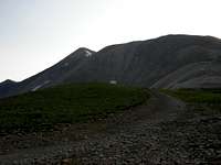
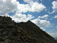
![Sunrise from the Trail]() Looking down the valley.
Looking down the valley. Our guide got us up the next day at 4:00 AM. Since this would be my first 14er, the 4 AM start was not that bad. I was too excited to care. We set out. Looking down the canyon, the Arkansas river valley could not be seen, giving the illusion that we were floating in the sky. The sun rose slowly and after about 90 minutes of hiking we were about halfway up. With the summit in view we set out for our final assault.
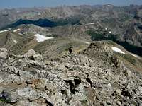
![Antero From the trail]() The summit in sight.
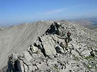
The summit in sight.![Final Ridge to summit]() The easy ridge to the base
The easy ridge to the baseSlogging up the switchbacks, we made it to the final ridge dubbed the "Devil's Backbone". It may look hard, but its a piece of cake. We traversed the ridge, closing in on the summit. After about 15 minutes we made it to the base of the summit. After 20 minutes of furiously scrambling up the slopes of Antero, the summit snuck up on me. I felt an intense rush and I wanted to scream. I was standing atop my first 14er. The gorgeous mountains of Colorado unfolded around me in all directions. It was the most beautiful thing I had ever seen. 3 hours and 15 minutes to the top.
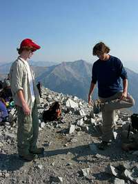
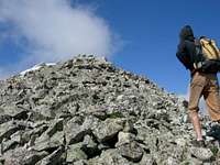
![Hacking on Antero]() Busting out at 14,000
Busting out at 14,000![Summit Antics]() Acting stupid on the summit.
Acting stupid on the summit.Almost a camp speed record. Great weather and no signs of thunderheads in sight. We took our pictures, hackysacked, and talked to the others on the summit. We spoke to some girls who go to Sanborn Camps who knew somebody from my school that I know as well. Man, its a small world. A half hour slipped by as we basked in glory on top of Antero. It was time to go down. We quickly descended, but trouble was brewing with my friend's psycho dad, who was our adult leader. He has a knee problem that prohibits him from descending quickly. The rest of us shot down the mountain leaving him in the dust. The guide and my friends arrived at camp with absolutely no idea where our adult leader was. We waited a while, but he never showed up. We were really worried so his son and I hiked back up the trail in search for his father. We hiked another mile back up the mountain with no luck. Finally we saw someone on an ATV driving down the road. He asked us if we are looking for someone. They had found him. The guys on ATV's dropped him off and our leader unleashed his fury. He was yelling at us, and cussing. Man, it was ugly. Apparently our leader got lost on the trail. We were so far ahead of him and we didnt stop to wait. That was our mistake. He thought he had missed the trail and hiked all the way back up to the treeline after going down to 11,500 feet. In reality he was only a 1/4 mile from camp when he turned around back for the treeline. I have no idea what he was thinking. Maybe the altitude got to his head and he screwed up. He was pissed and gave us this long lecture about Scout rules. We honestly didnt care. He didnt say another word on the trail for the rest of the day. That was funny. The hike out took seemingly forever, but we made it. One down, 4 to go.
Whitewater and Monarch Crest
After Antero we had a few days rest between climbs. The day after our Antero summit day, we headed down the Arkansas river. We rafted Bighorn Canyon, which is one of the quieter sections of the river. After lunch we even spotted a few Bighorn sheep way up on a high ridge. We were having a really good day until we started getting hailed on. It was not very cold, it was the wind that was a problem. The wind whipped up and paddling was hard. One gust of wind blew us back up river straight into the rocks. The clouds were looking gnarly and we had front row seats to a sweet lightning show. We got back to camp, and the mountain across the valley were shrouded in thick clouds.
The next day, we headed out to the monarch crest biking trail. Weather was bogus. Low clouds, cold and windy. Not fun. It is about 30 miles round trip, but only 10 miles is uphill. The other 20 miles is all downhill. This was my first true mountain biking experience, and I have to admit, I was a little scared. Everything was moving by so fast, and I was not having much fun. Although, after some time figuring out the bike, I was flying down the trail, catching jumps and flying into the air. It was a solid adrenaline rush. It was awsome. I usually hate biking, but I have to admit that I had a blast. I highly recommend the Monarch Crest trail to anyone looking for a fun day.
Shavano and Tabaguache: The Vertical Mile
Past memories of the Antero climb loomed closer as the Shavano/Tabaguache climb crept closer. Only two of us were going to climb. Collin and I were the ones up for another long day. However, bad weather the past two days brought doubt into our minds. Only time would tell.
![Shavano from the Saddle]() From here we scrambled up and to the right
From here we scrambled up and to the right
The next day we woke up at 3:30 AM. After a short walk from camp, I looked at the sky. It was crystal clear and I saw a shooting star streak past my eyes. I took it as a good sign. We ate breakfast and took off. Our climbing party consisted of two guides plus Collin and I. We arrived at the trailhead at around 5 AM and we headed out. Man, we were booking it. After only about 90 minutes we were out of the trees. Shorty after emerging from the timber, the summit of Shavano loomed high above our head. It looked so close yet so far. We slogged up to the final saddle, picked a line and starting our final push. We climbed up and to the right. This part was grueling for Collin and I. It seemed to last forever. However, shortly after encountering the first scrambling of the day, we were at the summit.
![Summit Shot]() LaZ Boy
LaZ Boy Although, at the moment I was too tired to care. During our lengthy stay, we watched clouds build up on the side of the mountain and lounged on the top on the natural lazyboy at the very top.
![Tabeguache from the ridge]() Tabaguache from Shavano
Tabaguache from Shavano![Tabeguache ridge]() Hiking up the ridge to the top. In the picture is one of our guides.
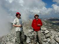
Hiking up the ridge to the top. In the picture is one of our guides.![Mixed Feelings on top]() V-day at least for me. Collin got sick on Tab
V-day at least for me. Collin got sick on Tab
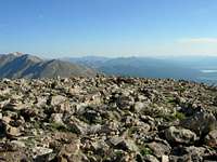
It was about 8:30 AM and time to tackle Tabaguache. It looked far away, but we summited in no time. When we got the the Shav/Tab saddle Collin and one of our guides got bad stomch pains. We began to acsend the ridge. It was slow due to our sick companions but we made it. The views were better than that of Shavano, but clouds were building over the far side of Shavano. We left some terrible yet funny remarks in the summit register and began our final descent. We took a short cut across the Northeast slopes of Shavano. After our tedious detour we were back on the trail. On the way down, I bit the dust because I was going too fast. I got a few cuts, but I was fine. Shortly above the treeline a loud clap of thunder sounded down the mountain. time to haul ass. We scurried down into the safety of the trees. After about another hour and a half we were back at the trailhead. It took us a little under 8 hours. Again, our guides were impressed. After the hike, I calculated the elevation gain, and was proud to say that I had climbed a vertical mile. Yet almost another camp record. Our troop was infamous for our speedy hiking that week. That Friday was our last day at camp and my dad was on his way so he and I could climb some more while our friends drove back home. Now only Yale and Elbert stood in my way.
Yale: Finishing the Job
The memories of last years failed attempt only fueled my urge to climb Yale. I was pumped, and we had been blessed with good weather the entire trip. Since our friends were headed back to San Antonio, it was my dad's turn to tackle a 14er. We met up with a close friend of my grandfather, Bill Weiss. He used to be a mountaineering guide and has summited Aconcagua along with other tall peaks of the Andes. Hes a pretty cool dude.
Sunday July 15, we started hiking at 4:30AM. The going was slow. My dad is in pretty bad shape, but he had only been in Colorado one full day before the climb. He was in for one hell of a day. The climb dragged on and on. Finally, we broke free from the trees. We could see Yale towering above us. Last year, I had only seen wicked looking rock faces through the clouds rushing by. Now our goal was in sight.
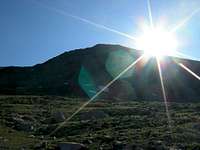
![First Sun]() My epic shot of Yale.
My epic shot of Yale.We hiked up to the spot where we had turned around the previous year. Now, my dad really started slowing down. Bill became impatient and flew ahead while I lingered behind with my dad. Soon we were at the base of the last switchbacks to the ridge. I tried to be patient with my dad, but it was hard. However, after the 120 mile bike ride prior to the trip, I now understood his pain. Nonetheless, I shot ahead of him and met up the Bill. We waited at the ridge before the last scramble for my dad. Man, pops was hurting.
![Looking Back]() The ridge.
The ridge.Once we got our wits together, and headed for the ridge. Bill was flying up, while my dad and I stayed back. The ridge was pretty fun, but I think my dad thought otherwise.
![Scrambling Up the ridge]() My dad, the ridge, and mountains.
My dad, the ridge, and mountains. Finally, I came over the last ridge, and there was no more mountain to climb. Bill and I waited on the summit, and I saw my dad's head pop over the ridge. Finally, after a year, we had finished the job. Yale was my dad's first 14er and my 4th.
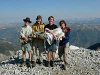
![Triumphant]() We did it!
We did it! We crashed at the top for about 30 minutes. The weather was the complete opposite of our last attempt. We could see Pikes to the south and Snowmass to the Northwest. I could even recognize Shavano, Tabaguache and Antero. I thought that was cool. Now for the sad part of the trip, we had to go down. We said farewell to Bill and he shot down the mountain to get home for dinner. Man, this guy is a beast. Before we knew it he was a speck 600 feet below. Surprisingly, I didn't bust my ass on the way down, but my dad did. When we arrived at the trailhead, we had been out for 10 hours. Wow that was a killer. Those slow hauls really get to me. We collapsed into our car and headed out. We ate at Subway, and I swear, that was the best Subway meal I have ever had. With 4 mountains down, only Colorado's higheset remained.
Elbert: Getting high in the Rockies
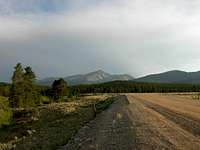
![Elbert from CO 300]() Elbert the night we drove into Leadville.
Elbert the night we drove into Leadville.The evening we rolled into Leadville, some strong storms had already hit the area, which made for some pretty interesting natural lighting. When we looked at Elbert from town, it just looked like this surreal mass of divinity. The whole mountain had an eerie green look to it.
Before the climb, I talked to a fellow SP member, James C. We had been trying to get together for a climb for a while now. We talked on the phone the day before the climb and got the details settled out. He said he was going to make it, but I had no idea how he was going to pull it off.
The day of the climb, we went through the same drill. We got up at 3:45 AM and drove to the trailhead. We got there at 4:30 and waited for James. I saw a car drive by, with music blasting from the car. That had to be him. After about 5 minutes, he found his way to the trailhead. At that moment, I knew this climb was going to be fun. After only a few words, we bolted up the mountain. Time flew by pretty fast and eventually we found a good spot to stop and wait for my dad. I was feeling really good about the climb. I was not too tired, and the view was good. Alpenglow lit up Elbert above us and the surrounding forrest.
![Mt. Elbert from along the trail]() Alpenglow on the NE ridge
Alpenglow on the NE ridge[We set off again, and busted into the tundra. We saw quite a few marmots on the trail. Dude, those little guys are awesome. We need those things in SA.
![A cool Marmot]() We saw this little guy chilling on the rocks
We saw this little guy chilling on the rocks[We took a break, and looked for my dad. Wow, he was way down there. I felt bad about that, and we waited again. We started to get cold, so up we went. We stopped again once the final leg was in view. We hung out with a marmot overlooking the valley. After spotting more people on the trail below, we were off. As we climbed, James recalled his past experiences on the mountain. As we ascended, more and more mountain came into view. Before I knew it, we were at the summit. Hell yeah, we were on the highest point in Colorado....cool.
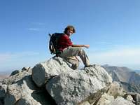
![Summit photo]() Summit shot.
Summit shot. As we would find out later, James and I were almost 45 minutes ahead of my dad. We soaked in the view and talked with everyone on top. I busted out my hackysack and went with it. One of the guys on the summit said he would hack with me if I took his picture. OK, thats cool. James and I started talking to this guy for a while. He was an old hippie dude who used to tour with the Grateful Dead, who are my dad's favorite band. What are the chances that we met this guy. My dad finally popped up over the ridge and walked over to us. Once again, my dad was out of it. Tired and proud, he took a long needed break. It was time to say bye to James. Pictures were taken, and he headed home. I stayed on top with my dad for a little longer taking wierd pictures of clouds and Mt. Massive. We bagan our descent, which I don't remember too well. I do remember seeing a bunch of little kids being guided up the mountain by some camp guides. I looked at the sky. The clouds were getting darker, how were these kids going to summit? We descended quickly and emerged at the parking lot. 7 days 5 14ers, quite an accomplishment for a flatlander. After two weeks in Colorado, I felt as though I had had my fill. Who would have thought. My hunger for the mountains had been sedated, but not for long. Driving back home the next day, the open plains made me dream of next year's climbing adventure.
Comments
No comments posted yet.