Prologue - February Attempt
My interest in mountains began when I was five years old. I had a Rand McNally road atlas that I could study for hours on end, and I was especially fascinated by the black triangles in each state signifying its highest point. I knew pretty soon that I was going to end up becoming a highpointer, even before I had ever heard of the term or knew what it signified. It was this interest in highpoints that got me interested in Mt. Elbert, which in turn was my introduction into the world of the Colorado 14ers.
I've always felt a special affinity for Elbert. Elevation wise it stands tall among the state highpoints, and it is also the highest peak of the entire Rocky Mountain chain. I've always found it to be a stately mountain worthy of its titles, even positioned next to Massive. The classic view from Leadville, in particular, displays a mountain that is very much self sufficient and symmetrical in its stature.
It was a cold January morning in Boston in 2007. I was on the commuter rail into work when I suddenly had the idea that, despite no mountaineering experience, despite barely any hiking experience, I was going to attempt to climb Elbert in the middle of February. I immediately slotted a week of vacation for the following month and drove down to Leadville. I did not even come close.
My planned route was the East Ridge. I made my way up the 4WD road to the upper trailhead. My brief sojourn on the Colorado Trail was disastrous; I knew that I was supposed to turn left at a giant sign, but for some reason I did it prematurely as I followed the packed trail and ski tracks. The ski tracks abandoned me further on up the hill, and as it was a warm day for February in the mountains, I was sinking knee deep into the snow with every step, even while wearing snowshoes. It was not for another hour before I realized that I was not even on the right trail. I saw the East Ridge right in front of me and knew it was where I was supposed to be. I also knew that the postholing and the soft snow would prolong the journey indefinitely, and that was just to get back onto the trail. So I turned around and began a painful descent to my car, only to find that it was stuck in the snow. I paid 500 bucks for a guy to come from Leadville and get it unstuck.
Second try in July
Despite the fact that I had failed only once on the peak (and had not even come close), I began to develop a nagging fear of it. My ultimate goal for my July trip was Elbert. I started off with Quandary and Sherman my first two days in the state. Day 3 was slotted for Elbert. I drove to the trailhead, only to find myself plagued by fear of the mountain that I knew to be irrational. I made a flimsy excuse tomyself and drove away, tail hanging between my legs. Somehow, through no merit on my part or its, Elbert had become a nemesis peak for me.
I ended up driving to Aspen and climbing Castle Peak the next day. The trip took enough out of my legs for me to realize that I needed to rest up for a few days. I felt the call of the desert in Aspen, and proceeded to take a 2 1/2 day sightseeing trip through the West Elks, Black Canyon, Arches, and Canyonlands. That sidetrip ended back in Leadville, where I knew I had no choice but to face this "mighty lump", as Roach's book calls it.
I arrived at the South Elbert trailhead around 530 AM resolved to make no excuses. The trip up the 4WD road went by in a surprisingly short amount of time, as did the hike up towards timberline. To my relief, I had no trouble finding the sign and turnoff this time.
![Aspen grove around 11,000 ft]() Aspens below timberline Aspens below timberline |
|
|
|
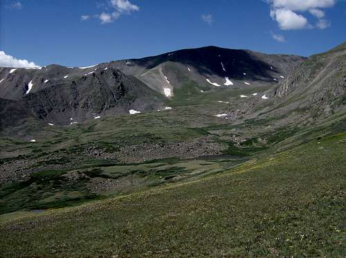
![Beautiful basin between Elbert and South Elbert]() Basin along the East Ridge. Lots of wildflowers in July Basin along the East Ridge. Lots of wildflowers in July |
Above the trees was a gentle section that rose very gradually through a tranquil meadow. It was a perfect day for a hike, and I found the lush basin between Elbert and South Elbert to be especially appealing. The only detraction to the hike were the swarms of mosquito's that plagued me until above 13,000', the first time they were an issue on this trip.
Ahead of me was a steep section of the trail that seemed somewhat forbidding to me. As I approached it I nicknamed it in my head as "the Green Hill." I know, really creative. Surprisingly, the section was not that bad, and by the time I passed it, I had also bypassed the mosquitos.
Here is where the trail got real deceiving. To my right was the NE ridge, a surprisingly steep and cliffy section between the two ridges, and a false summit that I knew was a harbinger of the real summit if one were traveling on the NE ridge route. Straight ahead was the giant lump that was Elbert's summit. My assumption was that the trail would head right up steeply towards the top. I was not pleased, then, when it decided to contour a long way south around the summit block, even losing a some elevation in places. This trail was too damn gentle!
|
|
|
![Mosquito Range]() Taken on the way back. The trail contours south around the summit before ascending it via switchbacks Taken on the way back. The trail contours south around the summit before ascending it via switchbacks |
|
|
|
|
Finally the trail began to switchback up. From my vantage point, I couldn't distinguish any features of the mountain besides the typical rock piles, so I really had no clue what kind of progress I was making. The switchbacks got a little steeper and shorter in between, which signaled the arrival of the summit. It was a class 1 trail all the way to the top, in the truest sense of the words (I found the Quandary trail to be looser than I expected for the last 500 feet before the summit). However, it was not easy. On some mountains you might gain more elevation than Elbert, but on Elbert you gain about 100-200 additional feet of HIGH elevation than your typical 14er. Thus, since I seemed to feel the altitude above 13,400 ft, I had that much more elevation gain above my watermark before reaching the summit.
I huffed and puffed my way to the summit, one that is supposed to be a magical place for highpointers and peakbaggers such as myself. Plus, I should have had an additional satisfaction of taking down a "nemesis" peak, however minor the enmity was. All I felt was a blistering cold wind that did not seem to exist below 14,438'. The views were great, the sky was perfect, but overall it seemed anti-climatic. Maybe it was because the climb was too easy, almost dull (compared to Castle a few days ago), maybe it was the cold, but looking back today I do not feel like I appreciated that moment as much as I theoretically should have. What WAS pretty cool and rewarding was seeing Castle and the rest of the Elks, including Snowmass and Capitol on the far horizon.
![Below the Summit]() Right below the summit. Right below the summit. |
![Elks from Elbert]() All Elk Range 14ers are visible from Elbert All Elk Range 14ers are visible from Elbert |
![La Plata]() La Plata La Plata |
![Another view of Massive]() Massive from summit Massive from summit |
To the extent of my knowledge, I was the first one on top that day, and I had the summit to myself for a few minutes before a few more parties arrived. I wasn't eager to stay long anyways, due to the wind. The moment I stepped off the summit, it died down, and the weather returned to the perfect conditions it had been all day. I ran into many more parties heading up as I was descending. One was a father and son duo gasping for breath around 13,600', just before the trail began to contour. I offered them words of encouragement, and found out that they had done Kings Peak the previous summer. I had always thought that Kings in Utah was more difficult than Elbert, but maybe it was the elevation. I hope they made it; they were nice, and I have a soft spot in my mostly lousy heart for highpointers.
Around 13,000' feet my right knee gave away again, causing horrible pain with each step. Around 12,800' I got a bad case of toejam on my left foot (big toenail fell off about a month later), so both legs were killing me now. Still, I had thousands of feet to descend, and no choice but to keep trudging along. I must've looked like a tall, pathetic penguin to any observers, limping down the mountain step by step. Fortunately, I don't think there were that many.
![Looking down East Ridge trail]() Looking down above my "Green Hill"
Looking down above my "Green Hill"
The pain did not detract from the scenery though. The aspens, evergreens, and meadows had a mellow, almost surreal quality to them that I did not notice on the way up. Even though there was nothing I wanted more than to get to my car, I could not help but take painful stops to snap away with my camera.
![Twin Lakes from Elbert]() Twin Lakes & E/W Buffalo
Twin Lakes & E/W Buffalo
|
|
![Sherman is a distance bump]() Sherman on the way down Sherman on the way down |
![Massive from Elbert s East Ridge]() Massive on the way down Massive on the way down |
![La Plata framed by aspen]() La Plata from the 4WD road La Plata from the 4WD road |
I eventually waddled back down to the upper trailhead. Again, the 4WD road took less time than I expected. I did not need a tow truck this time to return to Leadville, where I ate a quick lunch at a burrito joint. I had conquered my nemesis, bagged one of the highest state highpoints, but I felt bittersweet about it. I still had a few more days left in my vacation before the long drive back to Boston, but I soon came to the sad realization that my legs could not support another climb, not even an easy one such as Bierstadt or Grays. I decided to head home early, and at least be able salvage a weekend of drinking before returning to work. It was a tough decision, as I knew that I would not be able to return and see my beloved mountains for another year. I left Leadville and found an inn in Frisco, where my Colorado trip began a little more than a week ago.
The next day I committed a terrible sin: I drove up Mt. Evans. I couldn't help myself, as I just HAD to have one last taste of that fourteen-thousand foot air that I was now hooked on. I parked my car and walked around the exhibits and the overlooks, but did not walk up to the top. I'll save that for another trip, for when I do earn the summit.


Comments
Post a Comment