
Comments
No comments posted yet.
With a week of vacation still available to me (and the rest of my family having already spent a week at the beach without me) I decided to strike out on a week of highpointing with a friend or two, if I could. Multiple people were approached, but finding the triple-intersection of 1) interested in taking difficult hikes and long drives, 2) able to take a week off in August to join me, and 3) able to do this without offending the non-hiker members of their family proved difficult. In the end a college buddy made the commitment, which was good because the schedule as set was extremely tight, and required 2 overnight drives (which I cannot do unassisted!). We settled on the second week of August and started training...sort of.
Pennsylvania may have mountains, but sigificant elevation it does not, and I will be the first to say that my training for what we were to attempt was sub-par. The plan included Elbert (CO), Kings (UT), and Granite (MT), with some drive-ups on the way home. None of the big three can be considered easy; Granite in particular is a very long and difficult hike to complete in one day. But on Friday, August 6 I got off work around 3pm and immediately headed west. I got dinner at the I-70 split in New Stanton and met up with my friend from Indiana (PA). We chased the sunset into Ohio and continued the drive west through the night.
After enjoying a country breakfast in eastern Missouri, we opened our coolers for a picnic lunch at the Geographic Centre of the Continental United States in Lebanon, KS. This is a neat little pull-off, and US-36 is a lovely way to cross Kansas instead of sticking to the I-70 slab. We snuck into the extreme southwest corner of Nebraska to get TJ a new state, ate dinner in Fort Morgan, Colorado, and took I-76 down to Denver.
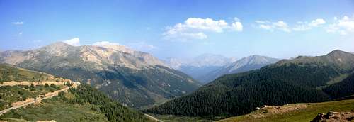
By this point, the smoke, which had been visible in some sense since Missouri, became absolutely atrocious. Even from downtown Denver you couldn't see the Front Range, which is typically the best part of driving across eastern Colorado. We took I-70 up into the mountains and enjoyed a fairly empty interstate since I-70 was still closed from mudslides east of Glenwood Springs. We split off onto CO-91, got pictures of the Continental Divide at Fremont Pass (and found out how COLD it was at that altitude!), and arrived at the Black Cloud trailhead around 9pm MDT (or 11pm EDT from our departure the day prior).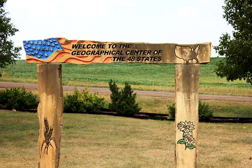
After a reasonably good night's sleep in the car we were up and on the trail before daybreak the next morning. The trail starts up immediately, and I had a hard time making any real progress on my bagel as we set a strong pace. Dawn brought views across the valley to Rinker and La Plata peaks. The haze was still present, but not nearly as heavy as the evening before. We were well above the treeline when the sun crept over Elbert's east ridge and bathed us in its heat. Our pace, though steady, was not at all quick. For sure our training was insufficient for anything faster, and a lack of VO2 Max severely limited oxygen at this altitude. It was 36 hours since we had left the diminutive elevations of Pennsylvania, and our overnight stay at the trailhead hadn't really given us a chance to acclimatize.
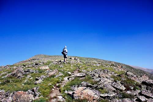
We finally attained the ridge, having seen only two other hikers (both hiking solo) so far. We took stock, observing just how far away the summit was, as well as how much elevation we had to gain, then lose, then gain again to make it there. The elevation at the saddle between Elbert and Bull Hill is about 13,900', and you could contour around the 500' prominence between you and that point, but we stuck to the cairn-marked trail and went up and over. Many stops for breaks and photography were permitted, as you are essentially ridge-hiking at 14,000', and as stated our acclimatization was thoroughly sub-par at this point.
The final push from the Elbert-Bull saddle to Elbert Summit was laborious. The terrain is very rocky, with the rocks themselves becoming small boulders. Cairns are present, but you are essentially just following the ridge to the summit. We could see masses of people at the summit, and were keen to join them, but (and I can't emphasize this enough) the altitude was a true and utter bitch. When we finally summitted we both just sat down for a rest before ever thinking of taking brag photos.
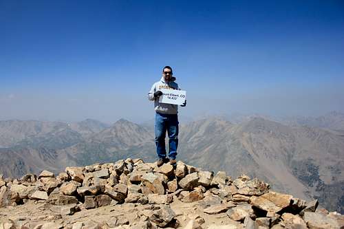
The summit area was fairly large, the wind was mostly calm, and generally it was just a nice place to hang out. It was very busy, with chains of people traipsing up and down the South and North Elbert trails to and from the summit. Someone had even summitted with their dog! When the heart rates were back under control, we found that a delightful summit sign existed, which we appropriated for the necessary photos. You can see the level of smoke/haze in the background. This brought us some concern, along with our obviously insufficent endurance for the 20+ mile hikes we had planned for ourselves in Utah and Montana. We now considered these hikes far-fetched based on our current fitness level; plus the smoke was supposed to be worse to the north.
As we started back down the ridge, we considered our options. We could continue as planned and see where the trails took us, or we could re-route mid-trip to something with a shorter approach and (hopefully) less smoke. Increasingly, the latter looked likely. The further down the trail we went, the more TJ's knees began to bother him, and his pace slowed considerably. The sun was also beating down at this point, and we were hustling through our water with reckless abandon. Eventually I started hiking ahead until I got to the upstream crossing of Black Cloud Creek, where I filtered water to fill several bottles. I brought these back up to a lumbering TJ and we made our way down the trail. Below the treeline, the trail seemed to drag on forever. What had seemed quick during the pre-dawn amped-up start of our day now seemed endless. We could hear occasional traffic noise from CO-82 below, but still the trail continued. FINALLY we saw the cars and the end of the trail. It was a little after 4pm, or about 13 hours after we had left the car.
After recovering at the car and packing up our things, we drove west on CO-82 to Independence Pass, the highest paved pass in the country. TJ was definitely feeling some altitude sickness at this point, and he hung out in the car, but I took some photos and enjoyed the views. We continued west to Aspen, naively hoping for cheap-off season housing. Ha! Aspen is (apparently) never cheap, and though we enjoyed some delightful brick-oven pizza to fill our hungry bellies, we declined the $200/night price for lodging. We tried several USFS campgrounds, but all were full, so we ended up parking at a pull-out on CO-82 and sleeping in the car again.
(This is Part I of a multi-mountain trip report. Part II continues here.)