How to Enjoy This Page
This trip report is made to be enjoyed from a variety of
perspectives. If you just want to see more photos of the aptly-named
Enchantment Lakes region, click on any picture. Each caption includes
links to the first picture, the ones before and after, and to this
article. You can cycle through all the pictures without reading all
the boring stuff about me.
Or read the text below to learn about my trip through the area,
and why I did it backwards, compared to saner folks. Clicking any
photo will take you to its own page with additional info in its
caption. Clicking the photo on its own page will bring up the
full-size version. Most will fill your screen, if you want that much
detail.
If you're considering a trip like this, I've tossed in some stuff
at the end about what I carried and wore. It's a fairly strenuous
hike, but very enjoyable if you travel light and the weather favors
you. If you're planning your first trip into the Enchantments, you
might want to follow the trail on Acme mapper. This
link will open a separate window, starting you at the Snow Creek
trailhead, where I started hiking. Follow the trail south from there.
WHY?
 Even
by the standards of Washington State's Cascade Range, the
Enchantments are spectacular. A traverse takes you through fragrant
pine forest, past clear mountain lakes to an alpine plateau, well
sprinkled with more lakes and surrounded by sharp granite peaks. You
continue to an upper plateau – tundra, streams, more lakes and
mountains, culminating in a barren landscape of rock and tarns,
almost devoid of any green. Then the view down onto a perfect jade
teardrop lake below and a descent past the lake to one more
delightful valley and a fine forest trail out. This compact
concentration of natural beauty is easily worth taking a week to
explore, even if you don't pursue the technical climbs. Add in those
peaks, and you could spend years in there.
Even
by the standards of Washington State's Cascade Range, the
Enchantments are spectacular. A traverse takes you through fragrant
pine forest, past clear mountain lakes to an alpine plateau, well
sprinkled with more lakes and surrounded by sharp granite peaks. You
continue to an upper plateau – tundra, streams, more lakes and
mountains, culminating in a barren landscape of rock and tarns,
almost devoid of any green. Then the view down onto a perfect jade
teardrop lake below and a descent past the lake to one more
delightful valley and a fine forest trail out. This compact
concentration of natural beauty is easily worth taking a week to
explore, even if you don't pursue the technical climbs. Add in those
peaks, and you could spend years in there.
The problem is that other people have figured that out, too. The
Forest Service decided in the 1980's that they had to do something to
keep the Enchantments from being loved to death. They established
party limits, designated campsites, reservations, etc. to preserve
the beauty that brought hikers and climbers from the four corners of
the globe. Well, Seattle, anyway. Reservations are coveted. Even if
you plan your trip a year in advance and apply the day the
reservation system begins, you might be disappointed. Or you simply
may not have the time for a backpacking trip. Yes, the area deserves
days of exploration, but if the alternatives are a day trip or none
at all, take the day trip.
Personally, I was already familiar with the Enchantments before
this trip in '87. I'd hiked into and out of there from a variety of
directions on weekend trips or week-long vacations. I'd climbed the
most popular peaks multiple times and climbed other summits that many
local climbers haven't heard of. I'd been spoiled by the freedom
before quotas and reservations. My friends and I would have a weekend
climb planned for the west side of the Cascades, and when the weather
looked a little too cruddy on this side, we'd call each other up and
say, “To heck with Soggy Peak! Let's go to the Enchantments.”
You can still be that spontaneous now, but only between Oct. 15 and
June 15, or if you're not camping.
I'd thought about a day trip; some of my friends did it yearly.
The weekend after Labor Day looked promising: the weather forecast
was perfect, the highways would be relatively empty after the
holiday, and I'd been getting in enough weekend climbs to be
optimistic about my ability to finish it. I called my usual climbing
buddies, but nobody was available that weekend. I wasn't about to let
a perfect Saturday in September pass on the off chance of getting
another as Autumn closed in on me. I considered calling climbers I
don't know as well, but what if they turned out to be unable to go
the distance? What if I couldn't? What if I talked some sucker into
hiking it with me, only to force a turnaround because I lacked the
stamina to finish?
A solo trip added complications. The hike is 17 miles from one
trailhead to the other, then there are several miles of road to
complete the loop. I live 150 miles away, and there's no public
transportation to or between the trailheads. I wasn't about to beg
somebody to drive 300 miles so I could go hiking without them, and
I've never been good at driving two cars at once. I had a bicycle,
though. I could cram it in the back of the Subaru, leave it at one
trailhead and start hiking from the other.
OK, but that introduced another problem. The Mountaineers Creek
trailhead is about 2000 feet higher than the Snow Creek start.
Obviously I'd like to start hiking high and finish low, but that
would mean completing the loop by riding up steep, loose, washboard
logging road after a full day's hike. I wasn't sure I could handle
that first thing in the morning, let alone at the end of the day.
That's why I had to do the trek, why I had to solo it, and why I
had to start at the low end, setting myself up for a 7,000-foot
elevation gain. It wasn't the ordeal it sounds like, though. Read on.
The Trip
I drove across the mountains after work Friday, and up to the
Mountaineers Creek trailhead – the one that leads to Colchuck
Lake. I parked in the dark and poked around by flashlight until I
found a likely-looking bivy site on a mound W of the parking lot. I
stuffed my sleeping bag into a bivy sack, laid it out, and slid in.
In the morning, I looked for a place to hide my bike for a day.
The brush was too thin, so I simply locked it to a trailhead signpost
in full view of the parking lot. Part of the bike's protection was
its impracticality for the location. I didn't have a mountain bike;
this was a classic 1970's 10-speed, with drop handlebars, a skinny,
hard seat, and skinnier, harder tires. Only a damn fool would steal
it to ride on those roads.
I drove down to the Snow Creek trailhead, donned my fanny pack,
filled out a self-issue dayhike permit, and started down the trail at
7:00 a.m. Yeah, down. The first bit of trail drops to a bridge over
Icicle Creek at 1280+ feet. That elevation is quickly regained as the
trail switchbacks up the N end of the Stuart Range before contouring
into the Snow Creek valley and leveling out for a while.
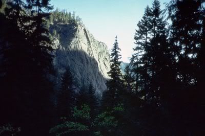 At
two miles and 2700 feet elevation you pass Snow Creek Wall, across
the valley and above you. By this point, less than an eighth of the
way through, I knew I was going strong enough to not only finish the
hike, but maybe even add a little extra. In all those earlier trips
in the Enchantments, I'd never made time to hike up Little
Annapurna. I'd keep that in mind today.
At
two miles and 2700 feet elevation you pass Snow Creek Wall, across
the valley and above you. By this point, less than an eighth of the
way through, I knew I was going strong enough to not only finish the
hike, but maybe even add a little extra. In all those earlier trips
in the Enchantments, I'd never made time to hike up Little
Annapurna. I'd keep that in mind today.
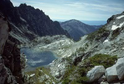
 At
5.5 miles I arrived at Nada Lake, elev. 4880+ feet. It was about
9:15, and out on the bare rock beside the water I met a couple of
backpackers soaking up the first sun to hit the lake. They were
bundled in down and wrapped around their coffee mugs for maximum
thermal transfer. I'd been generating excess heat for a couple of
hours, so I breezed through in running shorts and a cotton shirt. I
felt smug. A little further up the lake I found a rock that projects
into deep water, so I dived off it. No, it wasn't warm – none
of the Enchantment Lakes ever are – but I like to swim in
mountain lakes, and those guys had looked so cold, I had to show off.
I can be a real jerk that way.
At
5.5 miles I arrived at Nada Lake, elev. 4880+ feet. It was about
9:15, and out on the bare rock beside the water I met a couple of
backpackers soaking up the first sun to hit the lake. They were
bundled in down and wrapped around their coffee mugs for maximum
thermal transfer. I'd been generating excess heat for a couple of
hours, so I breezed through in running shorts and a cotton shirt. I
felt smug. A little further up the lake I found a rock that projects
into deep water, so I dived off it. No, it wasn't warm – none
of the Enchantment Lakes ever are – but I like to swim in
mountain lakes, and those guys had looked so cold, I had to show off.
I can be a real jerk that way.
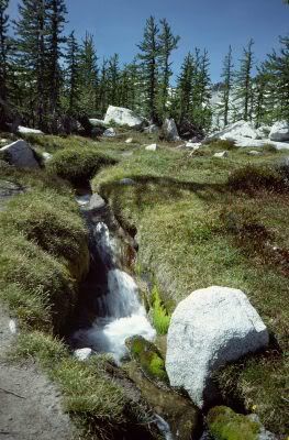
Nada Lake is almost split by a low peninsula on the W side. The
trail stays near the water to that point, then diagonals and
switchbacks talus above it. Off the end of a switchback a huge jet of
water was spraying over the talus. It's part of the effort to keep
all those famous Washington apples growing in dry summers. Upper Snow
Lake, still above us, has a 10-inch pipe poking up into it's water
and running through a tunnel in the granite to an opening above the
talus slope over Nada lake. In late summer, when Snow Lakes stop
providing sufficient water naturally, the valve is opened in this
pipe, allowing tons of water to spray over the talus, drain into Nada
Lake, and find its way down Snow Creek to the irrigation ditch that
parallels Icicle Creek. The pipe outlet is about 400 feet below Snow
Lake, so the water exits with tremendous force. I think the purpose
of the pipe's bulbous end is to make the water spread, so it doesn't
excavate a trench when it hits the hillside below.
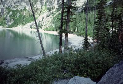
Almost as soon as Nada Lake passes out of sight, Snow Lakes appear
ahead. The trail meets them at 7 miles, 5420 feet, right at the dam
that separates Upper from Lower Snow Lake. The dam is just a little
rock wall – it's there to keep enough water in the upper lake
for that pipe to do some good. In early season the water flows over
the dam's top, and hikers have to wade it. In September the wall is
dry, and Upper snow Lake has extensive sand beaches with some
impressive sand canyons where small creeks come out of the woods.
 The
trail crosses the dam, then stays in the woods around the E and S
sides of the lake. It crosses the main inlet (still called Snow
Creek), turns left, then starts some serious climbing toward the
Enchantments plateau. Parts of the trail here are pretty thin; you
have to watch for cairns and blasted steps at times. Most people
backpacking in arrive here already dehydrated, in the hottest part of
the afternoon. It's a whole different experience in a fanny pack and
tennie-runners.
The
trail crosses the dam, then stays in the woods around the E and S
sides of the lake. It crosses the main inlet (still called Snow
Creek), turns left, then starts some serious climbing toward the
Enchantments plateau. Parts of the trail here are pretty thin; you
have to watch for cairns and blasted steps at times. Most people
backpacking in arrive here already dehydrated, in the hottest part of
the afternoon. It's a whole different experience in a fanny pack and
tennie-runners.
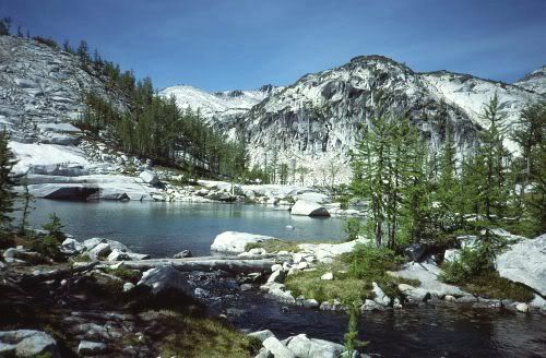
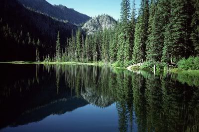
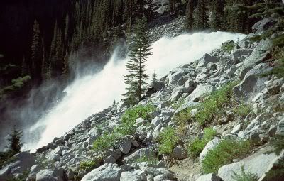
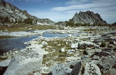
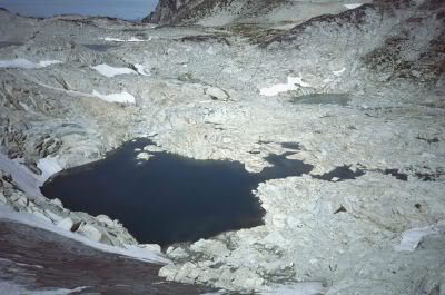
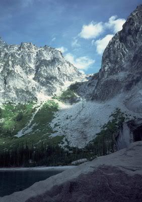
There is no vague transition zone between the Enchantments and the
valley below. You arrive to find Lake Viviane (10 miles, 6800 feet)
right at the edge of the plateau, it's crystalline waters plunging
immediately off the edge in a beautiful, cool waterfall. The trail
crosses the outlet on little logs, but I detoured to the right first
to dive off clean, white granite into deep water.
In the mile-and-a-half or so that the trail takes to cross the
lower plateau, it passes five lakes and assorted meadows, copses,
cliffs, streams and waterfalls. If you haven't been there before,
it'll knock your socks off. If you have, you'll wonder why you took
so long to come back.
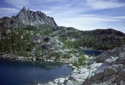
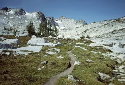
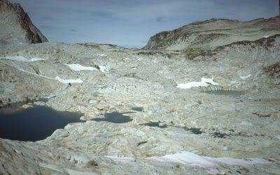
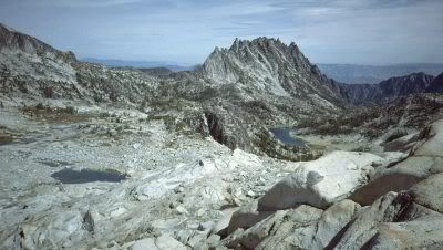
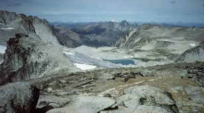
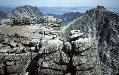
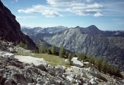
 The
upper plateau starts at 7400 feet. The trees thin out to occasional
larches dotting meadows laced with perfect little streams and ponds.
Farther up, it becomes just meadows among the rocks and lakes. Then
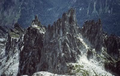
just lakes and rocks with bits of glacier thrown in. And mountains –
rounded humps and stark granite spires – mountains all around.
One of them I knew to be a walk-up that I hadn't climbed.
The
upper plateau starts at 7400 feet. The trees thin out to occasional
larches dotting meadows laced with perfect little streams and ponds.
Farther up, it becomes just meadows among the rocks and lakes. Then
just lakes and rocks with bits of glacier thrown in. And mountains –
rounded humps and stark granite spires – mountains all around.
One of them I knew to be a walk-up that I hadn't climbed.
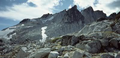
I found the turnoff to Little Annapurna and followed it. It was
mostly good trail, with some scrambling on solid rock and glacial
debris. I'll admit I was feeling the effort by now, but I wouldn't
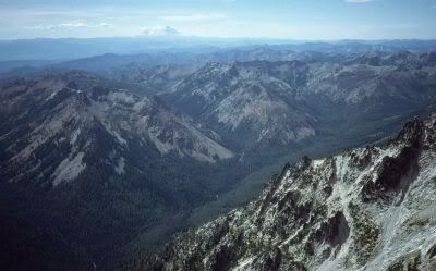
have missed the scenery. The top is broad and comfortable, with views
from Mount
Rainier to Mount
Baker. It's also about 7140 feet (2175m) above the bridge I
crossed back at the parking lot. The nearer views were the best: the
upper plateau was almost more lake than land, and the towers on
Little Annapurna's S side are about as rugged as rock gets without
falling over, though I was disappointed that The Flagpole was hidden
from there.
Time was getting to be an issue. As warm as the day had been, it
wouldn't do to be stuck out overnight in sweat-drenched clothes. It
looked like I could save some time by descending more directly toward
Asgard Pass (Colchuck Pass on the map), rather than backtracking down
the trail. Don't do that. My brilliant plan had me skirting glaciers
and picking my way down steep rocky slopes, sometimes resorting to
snow, but avoiding ice – mostly.
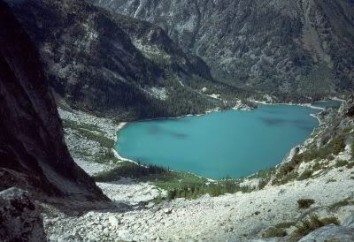
Eventually I found the trail and followed it up through country
that's at once desolate and so beautiful it hurts. The map shows the
trail through the Enchantments ending at Asgard/Colchuck Pass (7800
feet), but there's a steep trail that winds down the 2200 feet to
jade-green Colchuck Lake. Dean, in his Enchantments Area page,
recommends this trail as the short way into the area. My friends and
I call it The Death March to Asgard Pass. It's steep and loose, with
a touch of Class 3 tossed in. Lugging a multi-day backpack with rock
hardware up it on a hot afternoon will challenge your stamina and
your vocabulary. But lots of people do it every year, and hardly any
of them die, so have at it. Even if you don't do the whole traverse,
everyone who hikes in the Enchantments should stand at the pass to
gaze down on Colchuck Lake. After all those diamond-clear lakes on
the plateau, the view down to Colchuck is so... so...
Well, just go there.
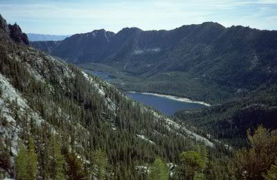
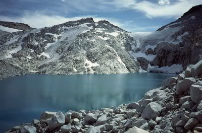
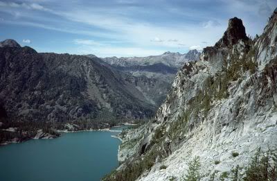
The trail down switchbacks mostly to the right of center (going
down). Arriving at the upper end of the lake, it skirts the S and W
sides and goes almost to the N end before turning left and dropping
toward Mountaineer Creek. The lake was low in September, leaving a
natural dam across the N end and some nice sand beach at the S end. I
did find a boulder over deep water at the S end. I dived off.
The 1000-foot descent from Colchuck Lake to Mountaineer Creek is
steep in places, but it's good trail, popular with weekenders. Down
at the creek (4600 feet), cross on an official footbridge, and
connect with the Mountaineer Creek trail. From here on out, I was
home free. A few miles of good valley trail separated me from my
bike. Watching the time, it occurred to me that I might make the
entire loop in 12 hours, if I hustled. I tried. I even jogged a few
steps. I think the Forest Service had been out there with their
trail-stretcher, because it was a lot farther to the parking lot than
usual.
My bike was waiting. It hadn't been molested, and I even had
remembered to carry my key. I've never had clip-in pedals, just toe
straps, so I could wear my running shoes on the bike. It was tougher
than I expected. My poor feet got hammered by the pedals on the rocky
road. On the steep washboard, I had to dismount and walk it down to
keep from getting tossed. (I was on a skinny-tire road bike,
remember?) I reached the paved Icicle Creek road, and was surprised
how fast that part went. I'd driven it often enough between the
various bouldering areas, but on a bike you notice the hills, even
the downhill ones. Now the problem was that I got too cold in the
wind.
I made it to the Snow Creek parking lot and my car at 7:15,
missing my 12-hour mark by 15 minutes. I could sit. I could drink. I
had dry clothes and a plastic bag for the stinky ones. I invested in
a shower and a spot on the ground at a private campground before
driving home Sunday.
Friends and relatives asked me later about how much I missed,
traveling through the area so fast. Granted, I didn't get to lie out
under the stars, and I missed out on all those technical climbs. But
even on week-long trips I didn't take many more photos than the 48 I
shot that Saturday. (All 33 of the photos I included in this TR are
from that day.) Little Annapurna was a first for me, and I'd never
swam in three lakes on one trip there before. I don't think I missed
out on much.
Equipment & Clothing
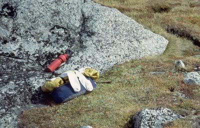 Not
much. I limited myself to a cheap, wraparound fanny pack, a water
bottle, and a camera. I wore nylon running shorts and a white cotton
dress shirt. Those are amazingly versatile – you can button or
unbutton as needed, roll up sleeves, whatever works. And if you've
ever worn cotton under a black light – remember high school
dances? - you'll remember how it glows a bright, electric blue. That
means that cotton, while fluorescing, is converting harmful
ultraviolet light to harmless blue light, so your shirt isn't
multiplying your sunburn. I didn't wear a tie. The fanny pack had a
polypropylene zip T-neck shirt and polypro bottoms to get me by in an
emergency. My yellow GoreTex parka was rolled up and tucked under the
compression straps outside.
Not
much. I limited myself to a cheap, wraparound fanny pack, a water
bottle, and a camera. I wore nylon running shorts and a white cotton
dress shirt. Those are amazingly versatile – you can button or
unbutton as needed, roll up sleeves, whatever works. And if you've
ever worn cotton under a black light – remember high school
dances? - you'll remember how it glows a bright, electric blue. That
means that cotton, while fluorescing, is converting harmful
ultraviolet light to harmless blue light, so your shirt isn't
multiplying your sunburn. I didn't wear a tie. The fanny pack had a
polypropylene zip T-neck shirt and polypro bottoms to get me by in an
emergency. My yellow GoreTex parka was rolled up and tucked under the
compression straps outside.
In preparing, I tried to anticipate the worst likely
accident that might occur to me. It's not hard to imagine being weak
with fatigue and stumbling when a rock rolls the wrong way. Suppose I
found myself at 7600 feet with a sprained or broken ankle? There
would be frost on a clear night. Would I make it through the night
and still be able to hobble or crawl the next morning? That was my
criteria. The weather forecast was perfect, without a hint of rain or
wind. All I needed was enough to survive a freezing night. If I
packed enough to be comfortable overnight, the extra weight
would make me slower, more fatigued, and clumsier, thus increasing the
odds of that worst-case scenario occurring.
My swimsuit was the one I was born in.
My shoes were the same ones I jog in, but I didn't wear my usual
cotton crew socks. Pick socks that match the activity, not the shoes.
I wore heavy wool hiking socks and thin nylon liner socks. I used my
swimming breaks as an opportunity to rinse my liner socks, then dried
them on my pack while I hiked in a second pair of liners. I don't
believe I carried spare heavy socks.
One reason for doing the traverse this late in the season is to
avoid carrying an ice axe. I missed it when I took that shortcut down
from Little Annapurna, but I shouldn't have been there at all; I
needed the sense to stay on the known route.
Water is of paramount importance on this or any strenuous trip.
Carry a hydration pack if you want, but I like my bicycle water
bottle for convenience.
I tie or sew ½-inch webbing
around the waist of a tall bottle, with another webbing loop tied or
sewn through the first. Adjust the length of the loose loop to allow
you to flip it over the top of the bottle. Normally I use a carabiner
to clip it to my pack strap at my hip. (Wrap the webbing around the
carabiner when you clip it, to hold the 'biner tight against the
bottle. Otherwise the bottle swings around and bangs against you.)
The bottle is always at hand, and I can unclip, drink, and clip it
again without breaking stride. I can fill it without taking my pack
off, and I can toss it in the dishwasher when I get home. When I
don't wear a pack, as on this trip, the loop fits over my wrist, and
the bottle rides against the outside of my hand as I walk. That might
sound as if it would constrict my wrist, but it's very comfortable,
even on a long day.
I had a gallon jug of tap water in the car, so I could start with
a full bottle and return to water at the car. Once on the trail, I
didn't purify my water. I carried iodine tablets, in case I had to
resort to suspicious-looking water, but I didn't use them. In water
this cold, the tablets take 10-20 minutes to dissolve, then you have
to wait 20 minutes for the stuff to kill the bugs. That's 35 minutes
without drinking, each time I refilled the bottle. I'd have been
wasted. I didn't get sick.
Traveling with friends gives you the freedom to rotate water
bottles, so iodine or other treatment is more reasonable.
My food was the usual granola bars, cheese, dried fruit, and trail
mix. Make sure you're getting enough salt.
I carried a 35mm Olympus XA pocket camera. It has a hard, sliding
cover and a 35mm lens. New digital cameras are much more portable and
versatile. I carried mine in a homemade pouch of doubled Cordura
Nylon, sewn to a loop of 1” webbing that I draped over my
shoulder. When I'm climbing, it gets banged around with my rack, but
holds up fine, and it's always handy for a shot.
Conditioning
If you climb mountains most weekends in Spring and Summer, and jog
on the occasional weeknight, you can do this. I've never been an
athlete. I'm in better shape than the average customer at the
all-you-can-eat buffet, but in a crowd of real mountain climbers, I
stand out as the slow, fat one.
I was able to travel so light (and traveling light made the trip
possible), because I trusted a perfect weather forecast. If the
forecast had called for overcast skies, I would have postponed the
hike. If the forecast had been wrong, I had some extra clothes. If
the forecast had been radically wrong, I would have been hurting. But
it wasn't.


Comments
Post a Comment