
|
|
Mountain/Rock |
|---|---|
|
|
40.77320°N / 110.68292°W |
|
|
Summit |
|
|
Hiking |
|
|
Summer |
|
|
12625 ft / 3848 m |
|
|
 North Allsop and Allsop Peaks
Overview
North Allsop Peak (12625) and Allsop Peak (12606) are two peaks located northeast of Allsop Lake in the High Uintas Wilderness area of Utah. They have no official names. I refer to them as such simply because that is how Scott terms them in his list of 12000 footers of Utah because the closest named feature is Allsop Lake to the southwest. I am putting both of them on the same page because they are very close to one another, .58 miles as the crow flies, and if you climb one, it is an easy stroll to climb the other. All the work lies in ascending to the saddle between the two. North Allsop Peak from Allsop Peak North Allsop Peak from Allsop Peak | 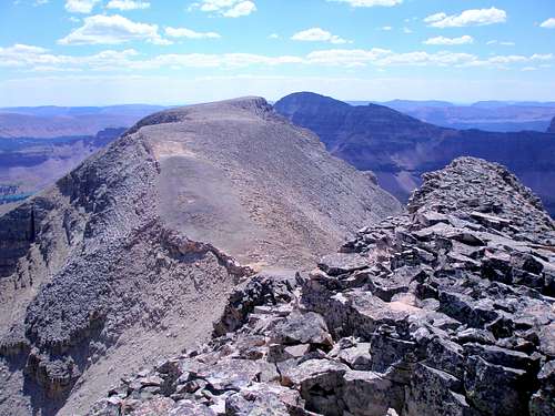 Allsop Peak from North Allsop Peak Allsop Peak from North Allsop Peak |
At 12625 feet, North Allsop Peak with prominence of 965 feet ranks 53 on Scott's list and at 12606 feet, Allsop Peak with prominence of 226 feet ranks 55. North Allsop Peak is the high point on the Beulah ridge and is 68 feet higher than Mount Beulah (12557), the only officially named point on the ridge. It is located 1.42 miles south of Beulah along the ridge.
 Beulah ridge, Mount Beulah is at the left
The Beulah/Allsop Peaks ridge is located between the Left Hand Fork of the East Fork of the Bear River and the West Fork of Blacks Fork. One ridge over to the east lies Tokewanna (13165), NW Wasatch (13039), and Wasatch (13156). To the west lies the Yard Peak (12706)/Cathedral (12224) ridge. To the south lies Dead Horse Peak (12642).
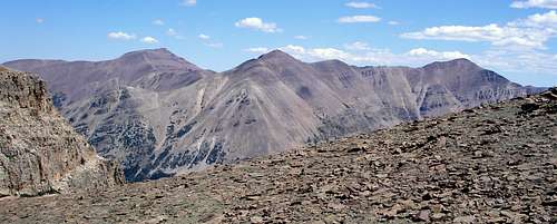 Tokewanna, NW Wasatch, Wasatch
 The Cathedral
Getting There
 On the way
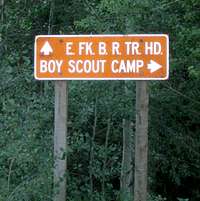
Access is via the East Fork of the Bear River Trailhead which is reached via forest roads 058 and 059 off of the Mirror Lake Highway which runs between Kamas, Utah and Evanston, Wyoming. Between mile markers 48 and 49, watch for a sign that says "E. Fk. Boy Scout Camp 6" and a smaller sign below that says 058. Turn east onto forest road 058. Drive 1.7 miles until you see another sign that says "E. FK. Trailhead 5". Turn right/south onto forest road 059 and drive 4.5 miles until you see a third sign that says "E. FK. B. R. TR. HD.". Bear left and drive .5 miles to the trailhead where you will find an outhouse and an information board.
Red Tape
There is a fee for parking at the trailhead as well as anyplace along the Mirror Lake Highway. You can buy an annual pass for $45, a 7 day pass for $12, or a 3 day pass for $6. You can also purchase an Interagency Annual Pass/America the Beautiful for $80 which is good for the Mirror Lake Highway and American Fork Canyon, as well as all Forest Service, National Park Service, Bureau of Land Management, Bureau of Reclamation, and US Fish & Wildlife Service sites charging entrance or standard amenity fees. Considering that the annual pass for just the Mirror Lake Highway is $45, the $80 pass good everywhere is a real bargain. The $45 and $80 passes can be purchased at the Kamas Ranger Station at the beginning of the Mirror Lake Highway in Kamas. The $80 pass can also be purchased at the customer service desk at REI. The $6 and $12 passes are available all along the highway in self pay tubes. However, it's not good enough to just buy the pass, you also have to prominently display it or you will receive a $75 fine. If you are an idiot like me and forget, you can head 2.1 miles toward Kamas on the Mirror Lake Highway to the Bear River Ranger Station and plead your case.Camping
 Allsop Lake
There are numerous established campgrounds along the Mirror Lake Highway. The Bear River Campground and the East Fork Campground are both located just south of the turnoff to the trailhead and are the closest. There really isn't any good place to set up a tent right at the trailhead since it was burned out in 2002 and there are no bare spots since zillions of small aspens have sprung up.
On a multiday hike you have your pick of where to camp along the trail. Allsop Lake at the end of the trail is particularly nice. Check the message board at the start of the hike to see what the current camping restrictions are.
When to Climb
 Allsop Peaks in spring
The best window of opportunity is late June through the beginning of October.
The Mirror Lake Highway is typically closed from mile 14.5 to mile 48 from sometime in November until enough snow melts in the spring/summer. Exact dates vary from year to year. The plowing stops on the eastern end at the turnoff to the trailhead. This turnoff is not plowed and is gated so a winter ascent would require an additional 6 miles each way, just to get to the trailhead. In 2009 the gate was opened sometime between May 1 and May 7.
Routes Overview
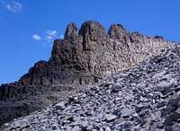
West side scree slope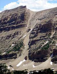
West Fork of the Black Fork
Just from eyeballing a map, it looks as though there are several potential routes up to the Beulah/Allsop ridge on the east side from the West Fork of the Black Fork. One promising route would be to ascend the NE ridge of 12484 (located just N of North Allsop Peak) and then follow the main ridge south to Allsop Peaks. Another potential route would be to ascend the scree slope on the east side of the N Allsop/Allsop saddle.
Mountain Weather
 Allsop Peaks
Here is a link to the current 7 day forecast for North Allsop Peak.