
|
|
Mountain/Rock |
|---|---|
|
|
40.72260°N / 110.3181°W |
|
|
Duchesne |
|
|
Hiking, Mountaineering, Scrambling, Skiing |
|
|
Summer, Fall |
|
|
13068 ft / 3983 m |
|
|
Overview
“North Emmons” or “North Mount Emmons” (a.k.a. “Pinnacle Peak”) at 13,068 feet is one of the highest peaks in Utah. It has 481 feet of prominence and is located just to the north of, you guessed it, Mount Emmons.North Emmons seems to be the most commonly used name for this peak, but David Rose’s book Utah Thirteeners uses the name “Pinnacle Peak” after an interesting and neat looking detached pinnacle on the east face of the mountain.
Unlike some of the other peaks farther south which tend to be somewhat shapeless domes, North Emmons is a rather shapely mountain that has a different appearance from all sides.
Like all peaks in the Uinta Mountains, except for Bald Mountain, North Emmons has no trail to the summit. It is a long way from the nearest road and the area is surrounded by many nice backcountry campsites in the basins and especially around the fishing lakes. Most people need to take several days (at least three) to climb this peak. Because the peak sits on the Kings-Emmons Ridge, several peaks can be climbed on the same trip, including one of the ultimate ridge runs available in the state of Utah.
The Uinta Mountains are one of the few mountain ranges in North America that run east to west rather than north to south. Within the Uinta Mountains are about 2000 lakes, and some 900-1000 are full of trout. Along with the San Juan Mountains in Colorado, the Uinta Mountains have more contiguous area above timberline than any other area in the Continental United States. This is a beautiful area with many lakes, meadows, wildflowers, and some rugged peaks. Solitude is usually easy to come by once you leave the popular fishing holes behind.
The Uinta Mountains are very rugged in the northeast section. Beginning at Hayden Peak and east to Mount Lovenia, the Uinta Mountains are not unlike the Tetons or other ranges. East of Lovenia, the peaks are more gentle, with a few rugged peaks (i.e. Red Castle and Henrys Fork Peak) scattered about until you are as far east as the Henrys Fork/Kings Peak area. East of Kings Peak, the Uinta Mountains become very gentle and the peaks are very rounded with only a few scattered cliffs about.
One thing that makes Utah's 13'ers different, then say the Colorado 14'ers, is that the distances from the nearest roads are usually much greater for the Utah 13'ers.
Utah's 12,000+ Foot Peaks With 200+ Feet Prominence
Utah's 12,000+ Foot Peaks With 300+ Feet Prominence
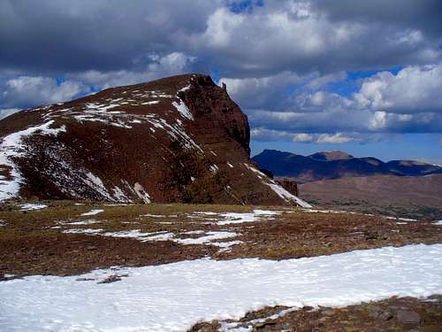 North Emmons from the saddle just south of the summit. The pinnacle on the east face can be seen.
Getting There
Uinta River Route:From the intersection of Highway 121 and Highway 40 in the town of Roosevelt in the Uinta Basin, drive west on 200 North (Highway 121). Stay on Highway 121 as it quickly bends to the north. Most junctions are marked with signs, but they are very hard to read in the dark. At mile 9.9, just after the actual mile marker 10 at a stop sign, at the hamlet of Neola go straight towards Uintah Canyon. At mile 16.7 continue straight. At mile 18, turn right to Uintah Canyon. At mile 21.9 turn right. At mile 22.2 turn left just after the bridge. Park at the trailhead at mile 25.6.
 The bridge not far from the Uinta River Trailhead.
Swift Creek Route:
First drive to the town of Duchesne, which is along US Highway 40. From Duchene, turn north onto State Highway 87. Follow State Highway 87 until it joins with State Highway 134 (this is where state Highway 87 heads due east instead of continuing north) between milepost 15 and 16. Follow State Highway 134 north to the little town of Mountain Home. Where State Highway 134 begins to head due east at Mountain Home, Continue north on the Moon Lake Road. After five miles, turn east on the Yellowstone River Road and to the Yellowstone River Power Plant. Continue along the Yellowstone River road to the trailhead at the end of the road, passing the Yellowstone River Dude Ranch and two campgrounds along the way.
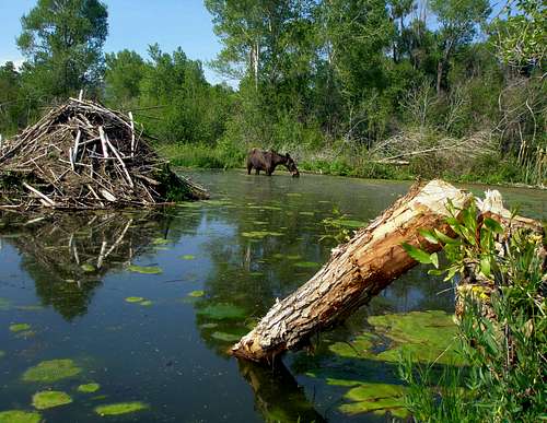 Beaver pond and moose as seen from the road to the Swift Creek Trailhead.
Routes Overview
Major access routes are Swift Creek Basin from the west, the Uinta River from the east, and the long Kings-Emmons Ridge from the north.I have only climbed North Emmons from the Kings-Emmons Ridge when passing over the summit of this peak.
There are variations to climbing North Emmons alone or first from both the Swift Creek and Uinta River Routes, but I have not climbed them yet.
The book Utah Thirteeners describes routes up North Emmons (Pinnacle Peak in the book) via the Southwest Face from Timothy Lakes in the Swift Creek drainage and the North Face via Roberts Lake in the Uinta River drainage. Because I have not climbed those routes, there will be no route pages until someone from SP climbs the routes and posts them.
North Emmons via the Kings-Emmons Ridge
This is a spectacular ridge run. Using the same standards that are used for the Colorado 14’ers, this ridge route has no less than eight 13’ers. This is the highest continuous ridge in Utah, one of the highest in the United States, and certainly the highest in the United States outside Colorado.
Briefly put, you will climb Kings Peak from the Uinta River or Swift Creek and follow the ridge all the way to Mount Emmons, where you will descend either the Uinta River or Swift Creek routes back to your vehicle. The route usually takes 4-5 days. South Emmons can also be easily added to the ridge run. See the route pages for much more detail.
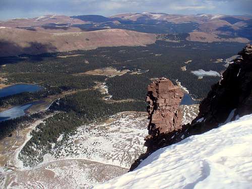
 Looking north from the summit.
Red Tape
No permits are required. Normal wilderness rules apply.Camping
There are campgrounds at both the Swift Creek and Uinta River Trailhead. No reservations are needed.There are many backcountry campsites along the trails. Some of the best ones for a are mentioned in the route descriptions.
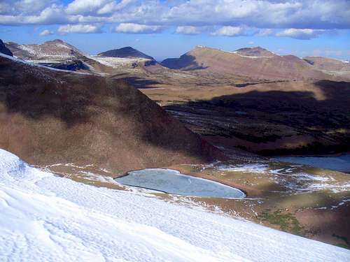
 This is the 4th Chain Lake. The lakes are popular places to camp, but the lower ones have the best campsites.
When To Climb
Mid-July through Mid-September is the normal hiking season.In winter the road is opened to within 4 miles of the Swift Creek Trailhead and provides rather easy (by Uinta Mountain standards) year round access. This is the only practical way in for a winter climb unless you have a snowmobile. The roads to the other two trailheads are closed in winter.
 View from North Emmons in October.
Fishing
All lakes mentioned in the route descriptions, and also the Uinta River and Swift Creeks have great fishing.Mountain Conditions
Information regarding the conditions for climbing Mount Emmons can be obtained from Wasatch-Cache National Forest, 8236 Federal Bldg., 125 S. State Street, Salt Lake City, UT 84128, (801)524-3900.Weather Forecast for Central Uinta Mountains
Here are some average highs and lows from the 13,123 foot elevation (4000 meters) in the Uintas (about the same altitude as the summit):
| MONTH | HIGH | LOW |
| JAN | 11 | -4 |
| FEB | 13 | -2 |
| MAR | 16 | 1 |
| APR | 24 | 8 |
| MAY | 32 | 15 |
| JUN | 42 | 22 |
| JUL | 52 | 29 |
| AUG | 50 | 28 |
| SEP | 42 | 21 |
| OCT | 31 | 12 |
| NOV | 19 | 5 |
| DEC | 14 | 0 |