
|
|
Mountain/Rock |
|---|---|
|
|
40.70400°N / 110.311°W |
|
|
Duchesne |
|
|
Hiking, Mountaineering, Scrambling, Skiing |
|
|
Summer, Fall |
|
|
13170 ft / 4014 m |
|
|
Overview
“South Emmons” or “South Mount Emmons” (a.k.a. “Glacier Peak”) is one of the highest peaks in Utah. At 13,170 feet, it rises 270 feet above the connecting saddle with the huge bulk of Mount Emmons, which lies just to the north. Because South Emmons falls just short of the 300 feet prominence criteria suggested by some for an official ranked peak, it is included on some lists of the highest peaks in Utah while omitted on others. If the peak was 30 feet higher or the saddle were 30 feet lower, there would be no question as to its stature.South Emmons seems to be the most commonly used name and was the name appearing in the first guidebook that mentions this peak (Utah Mountaineering Guide, 2nd edition), but David Rose’s book Utah Thirteeners uses the name “Glacier Peak”. This is very much a misnomer because there are no glaciers on the peak other than rock glaciers. Perhaps “Rock Glacier Peak” would be a more fitting name.
Like many of the peaks in the area, South Emmons is rounded and dome-like, though it does have some steep sides and slopes.
Like all peaks in the Uintas, except for Bald Mountain, South Emmons has no trail to the summit. It can be climbed on a long day trip, but the area is surrounded by many nice backcountry campsites in the basins and around the fishing lakes.
The Uinta Mountains are one of the few mountain ranges in North America that run east to west rather than north to south. Within the Uinta Mountains are about 2000 lakes, and some 900-1000 are full of trout. Along with the San Juans in Colorado, the Uintas have more contiguous area above timberline than any other area in the Continental United States. This is a beautiful area with many lakes, meadows, wildflowers, and some rugged peaks. Solitude is usually easy to come by once you leave the popular fishing holes behind.
The Uinta Mountains are very rugged in the northeast section. Beginning at Hayden Peak and east to Mount Lovenia, the Uintas are not unlike the Tetons or other ranges. East of Lovenia, the peaks are more gentle, with a few rugged peaks (ie Red Castle and Henrys Fork Peak) scattered about until you are as far east as the Henrys Fork/Kings Peak area. East of Kings Peak, the Uintas become very gentle and the peaks are very rounded with only a few scattered cliffs about.
One thing that makes Utah's 13'ers different, then say the Colorado 14'ers, is that the distances from the nearest roads are usually much greater for the Utah 13'ers.
Utah's 12,000+ Foot Peaks With 200+ Feet Prominence
Utah's 12,000+ Foot Peaks With 300+ Feet Prominence
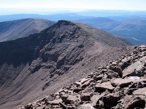
 South Emmons as seen from Owl BM.
Getting There
Uinta River Route:From the intersection of Highway 121 and Highway 40 in the town of Roosevelt in the Uinta Basin, drive west on 200 North (Highway 121). Stay on Highway 121 as it quickly bends to the north. Most junctions are marked with signs, but they are very hard to read in the dark. At mile 9.9, just after the actual mile marker 10 at a stop sign, at the hamlet of Neola go straight towards Uintah Canyon. At mile 16.7 continue straight. At mile 18, turn right to Uintah Canyon. At mile 21.9 turn right. At mile 22.2 turn left just after the bridge. Park at the trailhead at mile 25.6.
 A scene near the Uinta River Trailhead.
Swift Creek Route:
First drive to the town of Duchesne, which is along US Highway 40. From Duchene, turn north onto State Highway 87. Follow State Highway 87 until it joins with State Highway 134 (this is where state Highway 87 heads due east instead of continuing north) between milepost 15 and 16. Follow State Highway 134 north to the little town of Mountain Home. Where State Highway 134 begins to head due east at Mountain Home, Continue north on the Moon Lake Road. After five miles, turn east on the Yellowstone River Road and to the Yellowstone River Power Plant. Continue along the Yellowstone River road to the trailhead at the end of the road, passing the Yellowstone River Dude Ranch and two campgrounds along the way.
 Swift Creek somewhere not far from the trailhead.
Dry Gulch Trailhead:
From the Yellowstone River Power Plant mentioned above, drive north along the Yellowstone River Road to the first major road heading east (right). With a map in hand, follow this gravel road east to Dry Gulch. From Dry Gulch, turn left and follow the road north through Dry Gulch to its end.
Routes Overview
Because South Emmons shares its routes with Mount Emmons itself, it should come as no surprise that the routes are similar to either peak. Major access routes are Swift Creek Basin from the west, Dry Gulch from the south, Uinta River from the east and the long Kings-Emmons Ridge from the north. Because routes are similar to that of Mount Emmons, the route pages for both peaks will be shared.All routes described here with the exception of the route from Dry Gulch pass over the summit of Mount Emmons before climbing South Emmons.
There are variations to climbing South Emmons alone or first from both the Swift Creek and Uinta River Routes, but I have not climbed them yet. If you don’t want to re-climb Emmons on the return trip, you are on your own as far as route-finding goes. David Rose’s book Utah 13ers also describes variations of the routes below.
Note that the below information is meant to be an overview only, so for more details, see the route pages.
Uinta River Route
This is the easiest route to the summit of Mount Emmons and South Emmons. The route follows a good trail to the Chain Lakes (9.2-11 miles) where a base camp can be made. Form the Chain Lakes, the route to the summit has 2450 feet of altitude gain over two miles from 4th Chain Lake. The total distance from trailhead to summit of Emmons is 26-28 miles round trip (depending on route variations) with 5640 feet elevation gain. Add an additional 170 feet elevation gain and 1-2 miles (depending on descent route) round trip to include south Emmons to the climb.
It is possible to climb Mount Emmons from Lake Atwood, which is the next basin beyond the Chain Lakes, but this is a longer route. See the route page for more details.
 South Emmons is to the left. As seen from Lower Chain Lake along the Uinta River Route.
Swift Creek Route
Some say that this route is the easiest route to climb South Emmons and Mount Emmons, but I found it slightly more difficult than the route from the Uinta River. From the trailhead at the Swift Creek Campground, this route follows a good trail to the Timothy Lakes Basin.
There are several possible routes up South Emmons and Mount Emmons from the Timothy Lakes Basin and all are very steep. The total distance from the lake to the summit is 2.75 miles with 2440 feet elevation gain depending on route variations, but the last part up to the pass is very steep.
The total distance from the trailhead to the summit is about 25 miles round trip with 5440 feet elevation gain. Add an additional 170 feet elevation gain and 1-2 miles (depending on descent route) round trip to include south Emmons to the climb. See the route page for more details.
 Looking across Swift Creek Basin. South Emmons is the peak in the center.
Dry Gulch Route
This route is very seldom used and the trails marked on the map bear no resemblance to reality. The area has several long faded trails and a few old logging roads, but no marked trails. To complicate things, sometime before 1997, a huge storm caused a blow-down of several of the trees around the area south and east of Bollie Lake, which obscured what old trails there were. The route description will be rather brief as you must be able to route-find on your own to follow the route. A GPS comes in very handy in the forest.
This route follows and old track to Heller Lake and then follows an off trail route over into the drainage that is west of Jefferson Park and then to Bollie Lake.
From the lake, the route heads north to the ridge over Flat Top Benchmark (12,194 feet), and then along the long high ridge to Owl BM, South Emmons, Mount Emmons.
The total round trip distance from the trailhead to the summit of South Emmons and Mount Emmons is about 31 miles with much boulder-hopping. See the route page for more and important details.
Kings-Emmons Ridge
This is a spectacular ridge run. Using the same standards that are used for the Colorado 14’ers, this ridge route has no less than eight 13’ers. This is the highest continuous ridge in Utah, one of the highest in the United States, and certainly the highest in the United States outside Colorado.
Briefly put, you will climb Kings Peak from the Uinta River or Swift Creek and follow the ridge all the way to Mount Emmons, where you will descend either the Uinta River or Swift Creek routes back to your vehicle. The route usually takes 4-5 days. South Emmons can also be easily added to the ridge run. See the route page for much more detail.
 Kings-Emmons Ridge as viewed from the east and the summit of Marsh Peak. South Emmons is #2. Click on the photo for the identity of the other peaks.
Red Tape
No permits are required. Normal wilderness rules apply.Camping
There are campgrounds at both the Swift Creek and Uinta River Trailhead. No reservations are needed. There are also many informal campsites near Dry Gulch.There are many backcountry campsites along the trails. Some of the best ones for a are mentioned in the route descriptions.
 South Emmons is just right of center. There are many good campsites in the area.
When to Climb
Mid-July through Mid-September is the normal hiking season.In winter the road is opened to within 4 miles of the Swift Creek Trailhead and provides rather easy (by Uinta Mountain standards) year round access. This is the only practical way in for a winter climb unless you have a snowmobile. The roads to the other two trailheads are closed in winter.
 South Emmons from Emmons in late September.
Fishing
All lakes mentioned in the route descriptions, and also the Uinta River and Swift Creeks have great fishing.Mountain Conditions
Information regarding the conditions for climbing Mount Emmons can be obtained from Wasatch-Cache National Forest, 8236 Federal Bldg., 125 S. State Street, Salt Lake City, UT 84128, (801)524-3900.Weather Forecast for Central Uinta Mountains
Here are some average highs and lows from the 13,123 foot elevation (4000 meters) in the Uintas (about the same altitude as the summit):
| MONTH | HIGH | LOW |
| JAN | 11 | -4 |
| FEB | 13 | -2 |
| MAR | 16 | 1 |
| APR | 24 | 8 |
| MAY | 32 | 15 |
| JUN | 42 | 22 |
| JUL | 52 | 29 |
| AUG | 50 | 28 |
| SEP | 42 | 21 |
| OCT | 31 | 12 |
| NOV | 19 | 5 |
| DEC | 14 | 0 |