
|
|
Mountain/Rock |
|---|---|
|
|
40.79667°N / 110.55778°W |
|
|
Summit |
|
|
Hiking |
|
|
Summer, Fall |
|
|
12747 ft / 3885 m |
|
|
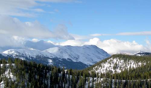
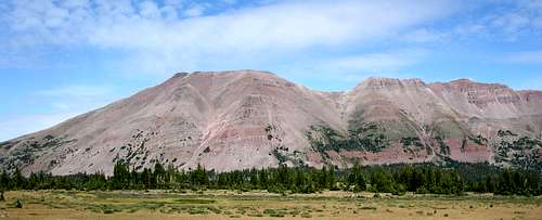 Northwest Blacks Fork Peak is on the left. Viewed from the westsouthwest.
Overview
There are 118 peaks over 12000 feet high with over 200 feet of prominence in the state of Utah according to Scott's list. Most of these almost never get visited. Even some of the 13000 footers on the list only see a handful of people a year. Those peaks that happen to be the high point of a county or have over 1000 feet of prominence are those most likely to be visited. The others lead a very lonely life. The peaks located in the heart of the High Uintas Wilderness are the most lonely of them all since they are located a long way from any trailhead.The ridge between the Little East Fork Blacks Fork and the East Fork Blacks Fork of the Uintas contains three such peaks that have virtually no chance of ever being visited, plus one peak lucky enough to have over 1,000 feet of prominence. This page details one of the unlucky ones, Northwest Blacks Fork Peak (12747'). This peak is the most northern and the most western of the four peaks. It has no official name, only that which Scott has given it. It has 287 feet of prominence and ranks 33 on the list. The other three peaks on the ridge from north to south are North Blacks Fork Peak (12788'), Central Blacks Fork Peak (12869'), and South Blacks Fork Peak (12769').
The ridge lies about 9 miles west of the Henrys Fork Trail, one of the most popular trails in the Uintas. But, unlike the Henrys Fork Trail, don't expect to see other people. After four trips to the Little East Fork Blacks Fork and East Fork Blacks Fork Trails, I've yet to see anyone else.
 NW Blacks Fork Peak viewed from the south.
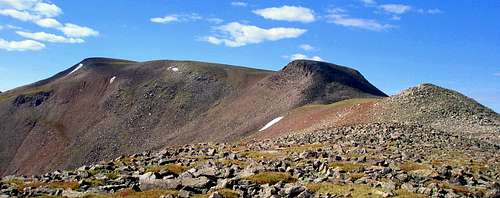 The summit is at the left, the knob is the second bump from the right
 Wasatch Benchmark, NW Wasatch, and Tokewanna Peak Wasatch Benchmark, NW Wasatch, and Tokewanna Peak |  The Squaw Benchmark ridge The Squaw Benchmark ridge |
Getting There
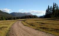 Northwest Blacks Fork Peak lies ahead
Take I80 to exit 34 in Wyoming and head to Fort Bridger. Go 5.3 miles to a blinking red light. Turn right on Wyoming state route 414 and go 3 miles to Wyoming state route 410. Follow 410 for 13 miles. First you will see a sign that says the pavement ends in 750 feet. Shortly you will see another sign for "Blacks Fork River Access Area" and then another one that says "Wasatch Nat'l Forest/Meeks Cabin 13". If you miss the signs, don't worry, the three sets of rumble strips should wake you up. Do as the signs say and turn left. The road you turn onto starts out paved but soon changes to dirt. Follow the main road 23.6 miles to the signboard (just past a gate) for the East Fork Blacks Fork Trail. The trail start is just before the signboard. There is no parking right at the trail start. Instead, continue on the road for just a few feet and turn right and then left into the parking lot.
On the Wyoming side, the dirt road is beautifully graded and maintained and you can make good time. Once it crosses the Utah border it gets noticeably worse and once it passes the intersection with the dirt road headed for the Mirror Lake Highway, it gets worse still. It's somewhat rocky but is fine for passenger cars if you go slow.
Red Tape
 The trailhead
Normal wilderness area restrictions apply. Check the signboard at the trailhead for the most uptodate information.
Camping
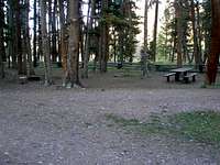 The campground
There is a free campground at the East Fork Blacks Fork Trailhead. There are 7 official sites all of which have fire pits. Four of these have picnic tables and three do not. Even on weekends, I've seen at most three sites in use. There is no water so you need to bring your own.
When to Climb
 Northwest Blacks Fork Peak June 6, 2008
If you want to avoid snow, mid July through the beginning of September are the best months. Creek crossings will be significantly easier later in the summer. The dirt road to the East Fork Blacks Fork Trailhead is not plowed in the winter.
Routes Overview
Blacks Fork Ridge Loop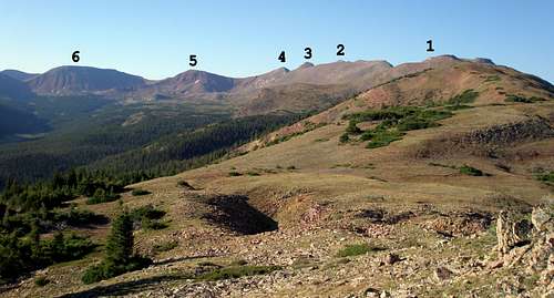 Peak 1 is Northwest Blacks Fork Peak
A nice loop hike can be made which climbs Northwest Blacks Fork Peak plus 5 other 12000 footers in one day. Start on the East Fork Blacks Fork Trail and head for the north ridge of Northwest Blacks Fork Peak. Head south on the ridge and hit Northwest, North, Central, and South Blacks Fork Peaks to the main east/west crest of the Uintas which is reached on South Blacks Fork Peak. From South Blacks Fork Peak head southeast down the main ridge and follow this ridge over West Oweep Peak (12507') and Oweep Peak (12531'). Descend to the Little East Fork Trail and follow it back to the East Fork Trail which is followed back to the start. The route is 21.3 miles long with a total of 6100 feet of elevation gain. It is primarily class 1 and class 2 with some short minor class 3 sections.
All six peaks of the route are shown in the picture at left.
Mountain Weather
 Northwest Blacks Fork Peak viewed from the east.
A typical summer day in the Uintas dawns without a cloud in the sky. By mid morning faint wisps of clouds are seen on the horizon. By midday the sky is half full of big puffy clouds. In the afternoon the sky is mostly overcast and possibly raining, but by early evening blue sky makes a comeback. Afternoon thunderstorms are frequent.
Here is a link to the current 7 day forecast for Northwest Blacks Fork Peak.
jfrishmanIII - Apr 20, 2010 11:23 am - Voted 10/10
LongitudeGreat page! Longitude figure needs a typo corrected, though: 110W, not 10W.
ZeeJay - Apr 20, 2010 3:14 pm - Hasn't voted
Re: LongitudeThanks! I fixed it.