Introduction
The kids were out of school and due to cutbacks, I had to take some unpaid time off, so it was a perfect opportunity to take advantage of the usually fine October weather in the Canyon Country. Kessler chose to go to the Maze in Canyonlands National Park. I had already visited much of the Maze, so we decided to explore Ernies Country which I hadn’t seen much of. Ernies Country is probably the least visited area of the Maze which itself is considered to be one of the most remote areas in the Lower 48.
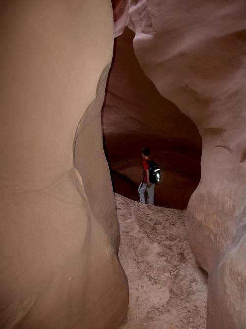
![Tarantula Canyon]() Exploring "Tarantula Canyon" on October 16 2009.
Exploring "Tarantula Canyon" on October 16 2009.October 15
I had chosen to access Ernies Country from the top of the Golden Stairs Trail for two reasons. Even though the drive is a rough 4wd road, it is much shorter than driving to the Land of Standing Rocks. The second reason was that I hadn’t used this access before to access the canyons of the Maze.
After spending the night in Green River, I picked up my Dad at the Green River Train Station and we drove the three hours (short as the crow flies, but with rough roads) to the top of the Golden Stairs. On the way we stopped at the ranger station to get our permit and to discuss parts of the route we planned to take. We learned that the spring at our planned campsite (Clells Seep) was dry so this would complicate things.
![China Neck]() Kessler crossing the China Neck on the Golden Stairs Trail.
Kessler crossing the China Neck on the Golden Stairs Trail.
The Golden Stairs Trail is a seldom used historic trail that was built in the 1930’s. It is rather rough, but by standards in this country, it makes a fairly easy access down the cliffs below. We followed the pretty good but washed out trail down the cliffs to the land of Standing Rocks Road.
![Golden Stairs Trail]() This is part of the view from the Golden Stairs Trail.
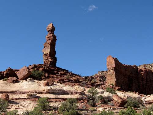
This is part of the view from the Golden Stairs Trail.![Rock tower]() This is the rock tower at the beginning of the Fins Trail route in the Maze.
This is the rock tower at the beginning of the Fins Trail route in the Maze.![Route into Ernies Country]() This is Kessler and my father on our route into Ernies Country on October 15 2009.
This is Kessler and my father on our route into Ernies Country on October 15 2009.
From there we headed east into the Ernies Country on the rugged Fins Trail (the national Park Service removed this route from all their recent maps, but the route is still marked with cairns so it isn’t that hard to follow). There were some steep scrambles, but it was a straightforward route to the bottom of the first canyon. We set off to explore the first canyon and found a really neat arch (Kessler called it Tornado Arch because of its shape) and found a nice Indian ruin before heading to Lou’s Spring where we set up camp.
![Indian Ruin]() This is one of the hidden Indian ruins we saw while exploring the area around Lou's Spring. This was the easiest of the ruins to find and get to. The ruins in the area date from about 1000 years ago.
This is one of the hidden Indian ruins we saw while exploring the area around Lou's Spring. This was the easiest of the ruins to find and get to. The ruins in the area date from about 1000 years ago.
After setting up camp we set off to explore the area. We explored several steep and exposed climbing routes up to the ledges above the spring. My Dad headed back while Kessler and I explored a very steep scrambling route up to near the rim.
![Climbing up to the ledges]() My dad climbing up to some of the ledge routes we found on October 15.
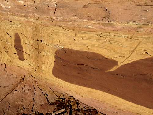
My dad climbing up to some of the ledge routes we found on October 15.![Rock texture]() This is some of the interesting rock texture around Lou's Spring.
This is some of the interesting rock texture around Lou's Spring.![Ledge route]() My Dad on part of the ledge route we found. Dad turned back just after here, but Kessler and I explored farther towards the rim.
My Dad on part of the ledge route we found. Dad turned back just after here, but Kessler and I explored farther towards the rim.![Rim route]() Kessler on a section of the route we found to near the rim above Lou's Spring on October 15.
Kessler on a section of the route we found to near the rim above Lou's Spring on October 15.![Near the rim]() Kessler near the rim above Lou's Spring on October 15. There was some tricky climbing required to get here.
Kessler near the rim above Lou's Spring on October 15. There was some tricky climbing required to get here.![Route]() This is part of the routes we found along the ledges and to the rim above Lou's Spring. Click on the photo for a full size view of the route.
This is part of the routes we found along the ledges and to the rim above Lou's Spring. Click on the photo for a full size view of the route.
At night the stars and Milky Way were really bright so I left the tent door open all night so we could see them.
![Life giving water]() In 1934 some of the CCC boys built this water trough at Lou's Spring back when sheep or cattle used to graze some of this area. This is the only life giving water around and in recent decades is little visited. The spring is barely dripping, but the water troughs below store the good water. Other than this spring, there are no other water sources for many miles in any direction. We set up our basecamp here for our four days of exploration.
In 1934 some of the CCC boys built this water trough at Lou's Spring back when sheep or cattle used to graze some of this area. This is the only life giving water around and in recent decades is little visited. The spring is barely dripping, but the water troughs below store the good water. Other than this spring, there are no other water sources for many miles in any direction. We set up our basecamp here for our four days of exploration.October 16
Today we set off for some explorations of the Fins area of Ernies Country. Because Clells Spring was dry, it would be a much longer walk than it would have been from our originally planned campsite. We hiked over to the canyon containing Whitmore Arch and explored it. Whitmore arch is rather hidden, but we thought we saw it from below, but weren’t sure. We continued exploring up canyon to find a fantastic and unexpected slot canyon.
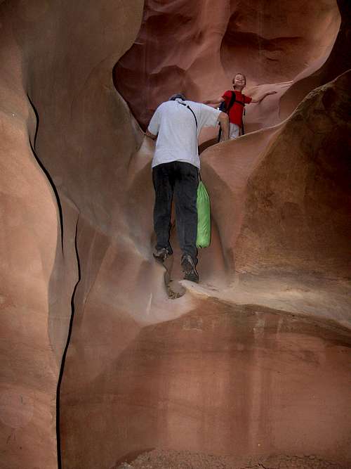
![Tarantula Canyon]() Kessler and my Dad climbing into a chamber of what we called Tarantula Canyon in Canyonlands National Park on October 16 2009.
Kessler and my Dad climbing into a chamber of what we called Tarantula Canyon in Canyonlands National Park on October 16 2009.![Exploring]() Kessler exploring "Tarantula Canyon" on October 16.
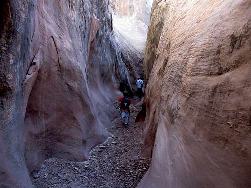
Kessler exploring "Tarantula Canyon" on October 16.![Tarantula Canyon]() In the narrows of "Tarantula Canyon" on October 16.
In the narrows of "Tarantula Canyon" on October 16.![Exploration]() Kessler explores the chambers of Tarantula Canyon.
Kessler explores the chambers of Tarantula Canyon.![Head of Navigation]() This is as far as we could get up "Tarantula Canyon". Above this there was an unclimbable dryfall.
This is as far as we could get up "Tarantula Canyon". Above this there was an unclimbable dryfall.![Twisty rock]() Some of the twisty rock in "Tarantula Canyon".
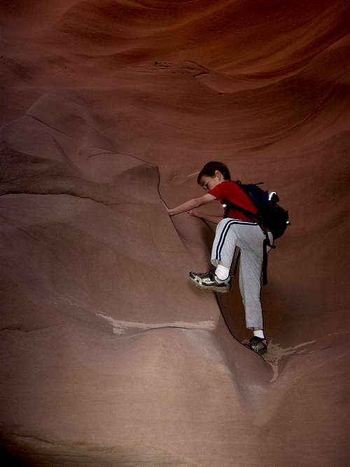
Some of the twisty rock in "Tarantula Canyon".![Climbing under or over obstacles]() We had to either climb over or under some of the obstacles while exploring "Tarantula Canyon".
We had to either climb over or under some of the obstacles while exploring "Tarantula Canyon".
After exploring and climbing through the slot canyon we were stopped by a 30 foot unclimbable dryfall and we headed back downcanyon. Kessler found a (dead) tarantula so we decided to call this canyon Tarantula Canyon. We decided to climb a rock fin so we could look for Whitmore Arch. Coincidentally, we reached the top of the fin right near Whitmore Arch. We climbed through Whitmore Arch and descended down the other side to the floor of the canyon before heading back downcanyon to the Fins Trail.
![Whitmore Arch]() We had to either climb over or under some of the obstacles while exploring "Tarantula Canyon".
We had to either climb over or under some of the obstacles while exploring "Tarantula Canyon".
We followed the Fins Trail east to the dry Clells Spring and then east to where it crosses Sand Tank Canyon. We would head up this canyon to look for Tibbitts Arch, which is the biggest arch in the Maze. It was a long sand slog up the canyon, but there were some spectacular rock fins along the way. We found another large arch before reaching Tibbitts Arch. We tried for about an hour to look for a route up the cliff bands to get into the arch, but we never found a viable route.
![Climbing]() We had to either climb over or under some of the obstacles while exploring "Tarantula Canyon".
We had to either climb over or under some of the obstacles while exploring "Tarantula Canyon".![Rock Texture]() This is some of the neat rock texture in Sand Tanks Canyon.
This is some of the neat rock texture in Sand Tanks Canyon.![The Fins]() These huge formations in Ernies Country are known as The Fins.
These huge formations in Ernies Country are known as The Fins.![Rock Tower]() A huge and impressive rock tower next to Tibbits Arch in Ernies Country.
A huge and impressive rock tower next to Tibbits Arch in Ernies Country.![Tibbits Arch]() Tibbits Arch is seldom visited despite the fact that it is the largest arch in The Maze of Canyonlands National Park. No trails get close to the arch.
Tibbits Arch is seldom visited despite the fact that it is the largest arch in The Maze of Canyonlands National Park. No trails get close to the arch.
It was getting late and we headed back down canyon and then back west to camp along the Fins Trail. It was a very long hike back and we hurried as fast as we could to beat the fading daylight. It was completely dark when we got back and we were lucky that we got back when we did as much of the route would be very difficult to follow in the dark. Kessler didn’t complain much, but did say that he was cold, hungry and thirsty. We had just enough water to make it back to camp. We had completed 15 miles in a single day (not bad for a seven year old and a 66 year old), nine of which were off trail and much of the route was rather rugged. The fifteen miles didn’t include our hour to try and find a route closer to Tibbitts Arch, so it was a long day.
October 17
After yesterday’s very long day, we decided on a shorter (but even more rugged) day. We followed the route up towards the rim that Kessler and I found on October 15. It was a rugged route and we had to climb several cliff bands. One of the cliff bands had some very old moki steps carved into the cliffs, indicating that this was a centuries old Indian route. We found one more Indian ruin and climbed several more cliff bands before reaching the true rim of Tarantula Canyon. We headed north along the canyon rim to look for Cave Arch. The Trails Illustrated map isn’t very detailed, so it would take lots of exploring to find the arch.
![Ridge Top]() This section of the slickrock is gentle, but some challenging climbing is just ahead.
This section of the slickrock is gentle, but some challenging climbing is just ahead.![Hidden Ruin]() This is a hard to get to and hidden ruin we found while exploring Ernies Country. Ruins in the area date back 1000 years. I wonder how many have visited the ruin since then? Probably not many.
This is a hard to get to and hidden ruin we found while exploring Ernies Country. Ruins in the area date back 1000 years. I wonder how many have visited the ruin since then? Probably not many.
We explored several nooks and crannies and were thrilled to find several arches and some flint chips and an arrowhead, but we didn’t find Cave Arch. We followed the rim of the canyon to the head of Tarantula Canyon and found a fantastic double pothole arch. It was really neat.
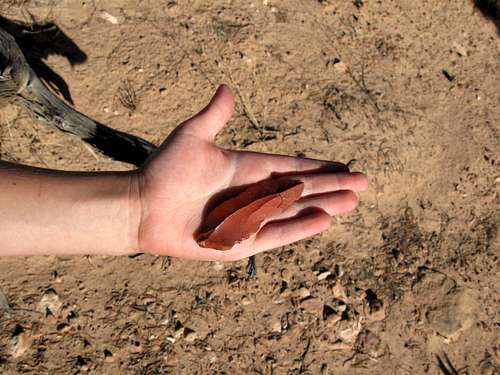
![Arrowhead]() This is an arrowhead we found while exploring the remote Ernies Country. We left it exactly where we found it.
This is an arrowhead we found while exploring the remote Ernies Country. We left it exactly where we found it.![Arches]() We found these two arches on our search for Cave Arch, which we never found. We had a rather difficult climb to get here, but we found lots of neat stuff. October 17 2009.
We found these two arches on our search for Cave Arch, which we never found. We had a rather difficult climb to get here, but we found lots of neat stuff. October 17 2009.![Dinosaur Head]() It really isn't one, but we all thought this rock looked like a dinosaur head. Look close and see if you can see it.
It really isn't one, but we all thought this rock looked like a dinosaur head. Look close and see if you can see it.
We explored the east rim of Tarantula Canyon and found a very steep and somewhat scary descent into the canyon. A pile of rocks strategically stacked rocks proved that others had preceded us sometime in the past.
![Interesting rocks]() These interesting rocks were deposited in layers and break in an interesting pattern.
These interesting rocks were deposited in layers and break in an interesting pattern.![Looking down]() Looking down what we call Tarantula Canyon. October 17.
Looking down what we call Tarantula Canyon. October 17.
We explored down canyon and explored another side canyon before eating lunch. While trying to get close to another arch, we found an obscure route back up to the rim. It was very steep, but not too scary. We circled around the rim over to a really impressive pothole arch. After taking photos, we found yet another neat arch.
![Climbing out]() Kessler and my Dad climbing out the steep route we found out of Tarantula Canyon.
Kessler and my Dad climbing out the steep route we found out of Tarantula Canyon.![Top of the route]() Kessler and my Dad climbing out the steep route we found out of Tarantula Canyon.
Kessler and my Dad climbing out the steep route we found out of Tarantula Canyon.
We never did find Cave Arch so we headed back towards camp. We looked for an easier route than the old moki steps route we found, but we never did find one. We returned to camp pretty early in the afternoon, so we had a rest before dinner.
October 18
Today we just packed up and headed back west along the Fins Trail. After the previous two days routes, it was a basically a piece of cake. We headed back up the Golden Stairs Trail. Even though it was uphill on a rugged hill, we made very good time and made the five miles in less than three hours. We enjoyed the views along the way before heading back for home.
It sure was a great trip and we got to explore some awesome country.
![Exiting the Fins Trail]() This is Kessler and my father on the Fins Trail after four days exploration. This trail is rather rugged in some places, but compared to out other days of trail-less exploration it was basically a piece of cake.
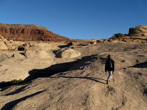
This is Kessler and my father on the Fins Trail after four days exploration. This trail is rather rugged in some places, but compared to out other days of trail-less exploration it was basically a piece of cake.![Ernies Country]() Looking down into the Ernies Country from the top of the Golden Stairs Trail. We explored among all the bluffs and domes and experienced some rather rugged climbing routes in four days, October 15 through October 18.
Looking down into the Ernies Country from the top of the Golden Stairs Trail. We explored among all the bluffs and domes and experienced some rather rugged climbing routes in four days, October 15 through October 18.


Comments
Post a Comment