


Comments
No comments posted yet.
|
|
Trip Report |
|---|---|
|
|
38.99971°N / 114.30347°W |
|
|
Jul 1, 2010 |
I truly expected this short first hike to be a foregone conclusion, and my altitude acclimation process to take only a day. Accordingly, I charged through the beginning portions of the Lily Mountain Trail. The confident mindset lasted until I reached the midpoint of the trail at about the time I expected to see the summit. My muscles were exhausted and I was developing a stiff headache. At only 9000’ the altitude began to shake my confidence. I slowed my pace and started to ration my insufficient water supply, yet I continued toward the summit in a mixed cloud of confusion and mild concern. When it did arrive, the extended rock scramble to the summit chased the concerns and invigorated me with emboldened spirit. The scramble and the accompanying view were my first real taste of the Rockies. After the preceding moments and days of unsteadiness, this taste replenished my hope and reaffirmed why I came.
The ecstasy of a Rocky Mountain summit lasted until the late afternoon, where I pushed my limits a little further on the Trail Ridge Road. This road is labeled as the country's highest continuous paved road as it winds through the heart of the park’s alpine tundra. I planned a few hours of sightseeing and photography, but once I pulled beside a group of grazing elk near the road’s high point at 12,183’ above sea level, my altitude sickness intensified further. I took a few pictures, grabbed a souvenir rock above tree line, and walked in the snow patches until the cranial pain eventually forced a retreat to my Longs Peak base camp. In spite of the discomfort, I managed to assemble my brand-new camping tent without any troubles, and I readily awaited an actual night of sleep outside of my car. I lied down inside to write a letter, but the headaches lingered and I found myself persistently out of breath. Even after extended idleness, I had to set down my pen and divert my full focus to breathing. This lasted through the evening and into the night. A nearby youth camp rally kept me awake for too much of it which, once my breathing finally settled, gave me nothing to do but think about Longs Peak. I never fully panicked about my health or well-being, but the symptoms did get my attention. My summit wishes seemed unrealistic now, but I was still right there on the doorstep of the trailhead. All I could do was just give it a shot.
 Alpine Bridge, Longs Peak East Trail. Alpine Bridge, Longs Peak East Trail. |
 Emerging from the forest. Emerging from the forest. |
 Entering the alpine tundra. Entering the alpine tundra. |
I began the hike with a very concerted effort to move slowly. Many other hikers passed me at a more considerable pace, but I remained steady in the hope that I could sneak up on the altitude with minimal exertion. The trail starts as a well-worn, mostly direct path through spruces and firs to the alpine transition zone two miles ahead.
 |
 |
 |
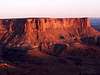
Longs Peak from Chasm Junction. |
||
 |
 |
 |
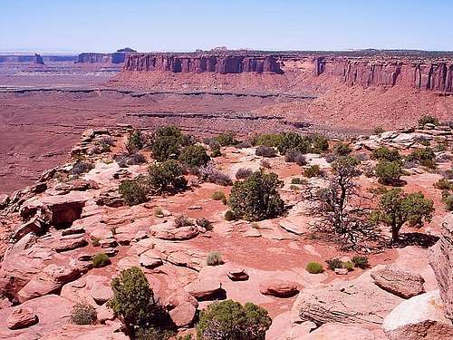
Views from Green River Overlook, Canyonlands National Park. |
||
The Island in the Sky plateau stretches south to Grand View Point, which can be reached by a short drive to a trailhead for a one mile hike. The hike takes you up and over many short staircases cut into the sandstone, which is soft enough to erode with your own hands. It also brings you close to an interesting natural feature present in these canyonlands, sandstone potholes called ephemeral pools. All of the potholes I saw were dry, but during rainy weather these tiny pools can surprisingly harbor their own ecosystems of snails and shrimp. At the point itself, with the sheer cliffs surrounding you on multiple sides, the panorama is breathtaking. The scale is almost that of an aerial photograph. Juniper bushes and boulders, significant at local ground level, seem to vanish entirely into a vast sea of red rock extending to the horizon. Adding to the mystique, a total silence goes nearly unbroken but for an occasional stray breeze. Time seems to stand still. It is just you and the canyons.
 |
 |
 |
 |
 |
Clockwise from north, the surroundings at Grand View Point. | ||||
 |
 |
Junction Butte to the south. |
My favorite picture from the canyonlands. |
Grand View Point was an ideal place for me to find a quiet spot and enjoy the tranquility and the views pictured above. I stayed there for most of the afternoon before grabbing a souvenir rock of red sandstone and eventually turning back for camp. The road back to Willow Flat was dotted with numerous overlooks and trailheads available for me to quickly explore in the daylight’s waning hours. I paused at the Buck Canyon overlook and at Mesa Arch, which offered tremendous potential for photographs. Though the natural arch - perched on the east-facing side - appears more suitable for sunrise photographs, I snapped a few to my liking with the setting sun behind me.
 First view of Mesa Arch from the trail. First view of Mesa Arch from the trail. |
 An angle of the arch and adjacent face. An angle of the arch and adjacent face. |
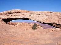 La Sal Mountains peeking through the arch. La Sal Mountains peeking through the arch. |
Finally, I completed my meandering route back to camp and caught the Green River overlook again. The west-facing canyon walls glowed a soft orange above the shadowy plateau. On the other horizon, the sky glowed a bright orange of its own. I lied down to sleep shortly afterwards, but there was one more treat in store for me. The crystal clear sky at night, along with the moon in its new phase, yielded the most spectacular view of the stars I had ever seen. The stars were noticeably brighter to me and seemingly infinite. The actual glow of the Milky Way was visible across the heavens. What a sight! It was yet another beautiful view on a day and night full of them in the canyonlands.
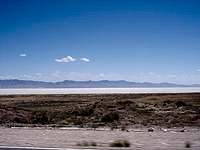
Stargazing in such a dark sky was a priority of mine on this new moon vacation, but I expected it to come first at my next destination: Great Basin National Park. My route to this terrifically isolated park on Tuesday morning was full of natural surprises. There were giant mountain ranges sometimes leaping up from flat basins and vast salt flats sometimes appearing out of nowhere behind them. Everything seemed random in this wild section of the intermountain west. I had no idea what I would find at Great Basin. What I did find was a startling oasis of life in middle of the desert.
The Snake Range and the national park within are fully surrounded by flat sagebrush desert valleys. But once you begin to ascend into the mountains, the vegetation increases both in quantity and variety. Sagebrush blends into a thick pinyon-juniper forest with plentiful green summer grasses along the ground. Further up, the forest is dominated by tall firs and the bright red barks of ponderosa pines. The alpine areas nearest to the bare mountain summits are inhabited by short, stunted firs and the heartiest plants of all, bristlecone pines. I started by exploring the lower pinyon-juniper forests first, as the Lehman Creek trailhead was conveniently near my Upper Lehman campsite. The rocky trail winding through the dense forest appeared like it may be heavily-used, but on this day, it was very quiet and isolated throughout my hike. I never saw another hiker, so as the only person on the trail, the idea of mountain lions stayed with me though nothing came of it. I turned around before I was able to climb above the forest and see any great views, so that was the extent of my experiences for the day. Tomorrow I would explore the alpine scenery.
 Lehman Creek beside my campsite. Lehman Creek beside my campsite. |
 Mather Overlook, Wheeler Peak Scenic Drive. Mather Overlook, Wheeler Peak Scenic Drive. |
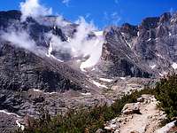
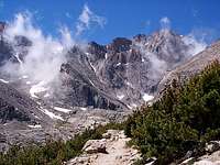
 Wheeler Peak and its awesome glacial cirque. Wheeler Peak and its awesome glacial cirque. |
I planned to enjoy the alpine areas and still tour Lehman Caves before Wednesday's sunset. So instead of returning to the Lehman Creek trail and finishing the partial hike I did yesterday, I drove the Wheeler Peak Scenic Drive to access the high trailheads. Most appealing to me was the glacier trail, with a loop through a bristlecone pine grove and a path to a glacier billed as the only one in Nevada. After a mile or two through the tall canopy of the sub-alpine forests, the terrain became much rockier, and the forest turned shorter and more dispersed. Soon, these short and dead-looking tree trunks began to appear, straight out of the rocks covering the ground. In fact, they were not dead at all, but rather living bristlecone pine trees. Bristlecones are the oldest trees on the planet, sometimes living for several thousand years in the inhospitable high altitudes. They are quite remarkable to look at, with sort of a waxy trunk and short twisted branches. There are scattered bristlecone groves throughout the west and the national park here is blessed with several of them. It was a very neat sight. I took some pictures of these resilient trees and a souvenir rock from the ground beside one, and I tried to comprehend their age.
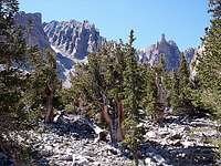 Within the bristlecone pine grove.
 This tree may have sprouted 5000 years ago!
 At the front of the glacial cirque.
 View from on top the rock glacier.
This grove in particular was just on the edge of the Wheeler Peak glacial cirque, so I eagerly followed the trail into the cirque, toward the rock glacier and imposing face of the peak. My excitement for seeing a glacier was a bit tempered though once I drew closer. There wasn’t really much of a glacier to see. Maybe the winter snows would replenish it, but here in July, the cirque held only a cascade of rocks and isolated snow patches. Still, the magnificent east face of Wheeler Peak was a treat, and I started to maneuver my way across the rocks toward it. After some time moving into the cirque, I began to better comprehend the scale of the area. Approaching rock piles always appeared smaller and closer than they were in reality, and my speed was limited by the tedious process of rock-hopping the uneven piles. The views looking out of the cirque got better and better as I ascended, so I continued to creep toward the face until I reached the highest rock pile, just in front of the remaining snow at the face of the peak. I rested here atop the highest reaches of a rock glacier, surrounded on three sides by mountain walls. The sky was deep blue and free of clouds. Ahead was the eastern Snake Range, with its rich coniferous forests climbing above the barren floor of the Snake Valley. This scene wasn’t anything I thought I would see in the Great Basin, but it was better than anything I could have dreamed up.
I could have stayed in the glacial cirque until my water ran out, but I left to catch a tour of the Lehman Caves after grabbing a souvenir rock from under a lingering snow patch. The caves were yet another amazing feature I would never have expected to be here. The formations inside were odd and varied. In some areas, rock seemed to hang from the ceiling like spaghetti. In others, it appeared like a curtain folded over itself. The sights were certainly interesting, but protected caves like this only allow you to indulge your sense of sight, so the enjoyment is limited. I probably would have been better off exploring the alpine areas further, but the cave was neat to see once. It was the conclusion of my introduction to the west, a memorable week of mountains and canyons.
Despite the total enjoyment I had in my week within the mountains, I went ahead with my plans to leave the wild and meet a friend for some recreation in Las Vegas. I stopped at Cathedral Gorge State Park for a much-needed shower, and best of all, it only cost twenty-five cents. Once I reached Las Vegas, we toured the World Series of Poker, dined at In-N-Out Burger, and gambled a bit on the strip before heading to Fremont Street. There was an excellent cover band that played a lot of my favorite songs by Def Leppard, Boston, Bon Jovi and others. The stage was set up right on the street in the middle of the casinos and liquor stores. We could buy alcohol and drink it openly at the concert area, or really anywhere for that matter. Unfortunately, I consumed significant alcohol and it clouded my reason when I started to fall behind on the blackjack games. Then I hastily tried to recoup the losses and I lost more, I actually had to borrow some of my friend’s money to enable me to make it back home. At least I slept well that night. The next morning, I left Las Vegas going south in order to cross the eastern extent of California and the Mojave Desert. At a random, unassuming place in the desert, I made sure to pull over and grab a souvenir rock. Other than that, it was a steady drive into Arizona, where my schedule was ruined. An Arizona state trooper thought I was driving suspiciously slow, about ten under the limit, and he pulled me over and fabricated a high speed clocking. I was a bit annoyed at that, and then he continued to grasp at straws and held me to search for drugs until back-up finally arrived. After wasting two to three hours of my time and his, I was finally freed to go to New Mexico, where I pulled over and relaxed extensively at the first rest area like it was a safe haven. All this time spent stationary meant that I could only get to Albuquerque before pulling over to sleep. On my second day returning, I started late and drove an easy pace through the remaining portion of New Mexico, then the Texas panhandle into Oklahoma. Though I cannot fully explain where the daylight went, I was merely through Oklahoma and into southwest Missouri when I had to pull over for the night again. I was tired and frustrated because, if the previous day’s driving had gone uninterrupted, I would have been home. The rest in my car was unpleasant, as I woke up early in the night drenched with sweat and a headache. I tried to cool off with a wash inside the rest area but my efforts were futile. The night must have been especially warm and humid because I walked past a Minnesota vehicle whose occupants were literally sprawling out onto the ground trying to sleep. It was an interesting idea, but I decided to drive to the next rest area with the air conditioner on high. It was an agonizing drive with equal parts pain and sleeplessness, but I made it to the next rest area safely and finally went to sleep. My long ordeal home would finally end on the eleventh day of my trip, as I arrived home around noon with body, automobile, pictures and memories all intact.