Utah 2013: A Return to the Desert
About five years ago, I visited the stark beauty of Southern Utah with my family. Returning home, I realized that I could repeat the loop that we'd taken visiting completely different sights of equal splendor. This year, I decided to make that journey. Using maps, SummitPost, and the wonders of on-line image searching, I planned out a week-long visit to these beautiful expanses of the Colorado Plateau. As part of my new itinerary, I decided that it would be nice to visit the Wave, but the on-line lottery told me that I wasn't invited. Undismayed, I packed my bags and headed to Utah nevertheless, with thoughts of swinging by the Kanab BLM office and trying my luck at the lottery there.
The Maze
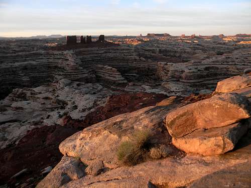
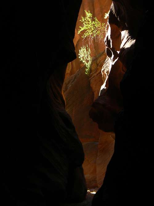
![View from the Maze Overlook]() The Maze Overlook: The Chocolate Drops are the towers in the middle ground, with the Land of Standing Rocks behind and to the right.
The Maze Overlook: The Chocolate Drops are the towers in the middle ground, with the Land of Standing Rocks behind and to the right.Shortly after college, I read Edward Abby's classic Desert Solitaire and was drawn to visit the lands that he described so eloquently with my future wife, Julie. When my parents saw our photos, they proposed that we return and visit both Arches and also the near mystical Maze, hidden far beyond frequented roads in the depths of Canyonlands.
Prior to the trip, I happened to mention to Julie that I'd never once heard my dad swear. Needless to say, just after reaching the Hans Flat Ranger station, we got a flat tire, then broke four lug nuts in replacing the tire and our attempt to reach the Maze was over. Later, I had to reaffirm to Julie that I'd truly only heard him swear once in my life…
Figuring that the Maze wasn't too far from the Wave, I made this my first destination, driving from Colorado, and then hiking down twelve miles to the Maze Overlook that same afternoon. Sadly, the miles seem longer now than they once did, and a little short of my goal, I set up my tent in a wash as darkness cloaked the land.
'It's low elevation,' I decided the next morning and left my sunglasses in my tent. After a dawn breakfast at the Maze Overlook, I spent the day in the deep sandy canyons, emerging for a while at the Land of Standing Rocks then descending again at the Chocolate Drops. Three things that I learned were that the famous pictographs are on the north side of the wash, not the south as my map indicated, that sun glasses would be nice in the desert, and that it is possible to slip and drench your feet in the only speck of water in a hundred square miles of desert.
This, though, was the canyon country that Abbey had fallen in love with half a century before with no people and only the call of the canyon wrens to keep you company. It's a land of sun and heat where rattlesnakes use your tent for cover and small creatures skitter between the shadows with your arrival.
Ferns Nipple
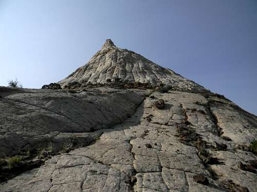
![Ferns Nipple]() View from the approach.
View from the approach.On the earlier trip with my family, I'd hiked to Cassidy Arch in Capital Reef (it's how everyone misspells my name) and couldn't get my eyes off of a stunning rock peak just to the south named "Fern's Nipple" (laughter from my daughter). The route described on the SummitPost page gives wonderful desert hiking and a beautiful summit, although traversing the break in the cliffs gets briefly tedious. A bit of the scrambling near the top is probably 4th class but never seems all that bad. I'd recommend starting at the base of the Grand Wash, hiking right from Rt. 24, through The Narrows, and then up almost to the Grand Wash parking lot off of the park's Scenic Drive prior to beginning the cairned ascent. It's longer but you get to hike through a nice canyon and then climb a beautiful peak at the same time.
That afternoon, at a visit to Anasazi State Park, I learned that Spooky and Peek-a-Boo Canyons were near Escalante, not Kanab, as I mistakenly believed. Rushing back to my car, I made a trip down Hole in the Rock Road, getting to the trailhead just as most others who'd been there that day were leaving. Perhaps the most profound moment was standing at the spot where the hundred foot wide Spooky Wash suddenly constricts into a narrow slot only a couple feet across. Beautiful, but not a place to be in a storm…
![Peek-a-Boo Canyon]() Peek-a-Boo Canyon
Peek-a-Boo Canyon![Peek-a-Boo Canyon]() Peek-a-Boo Canyon
Peek-a-Boo CanyonUpper and Lower Red Cave
The Wave Lottery has turned into quite a spectacle. The first day I went, 88 people all congregated in a little room amid the hundreds of miles of lonely desert vying to be one of only ten individuals to receive a permit. The BLM folks use the little balls that you see on TV drawings and pull them out until the permits are filled. After a long explanation of the dangers of heat and off trail hiking, they twirled the cage, one of the balls popped out and the room went silent as the ranger paused for dramatic effect. Finally he read the number, a beautiful young woman shrieked and hugged her husband while the ranger assured the rest of us that there were still 8 spots left. Eight people later, most, including me leave without the permit. Fortunately, as the ranger assures us, there are plenty of wonderful things to do nearby.
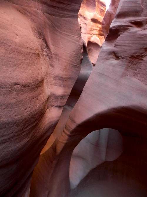
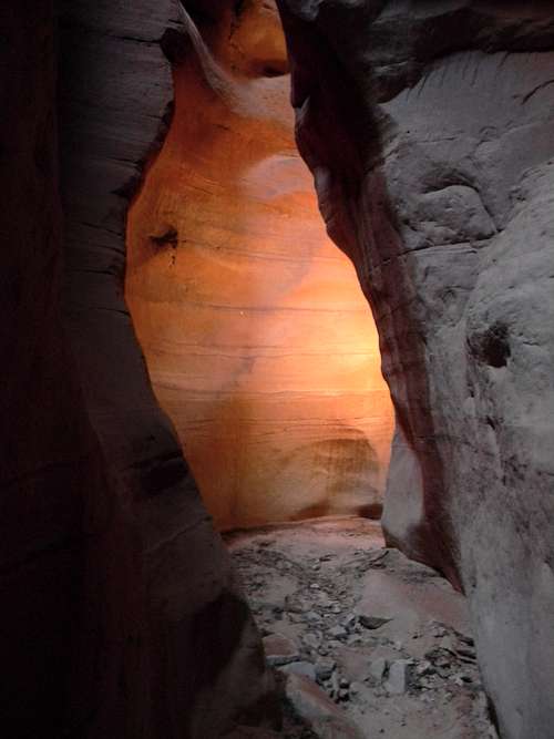
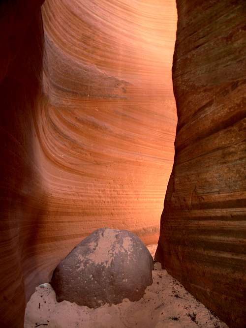
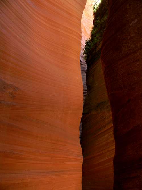
![Lower Red Cave]() Lower Red Cave
Lower Red Cave![Lower Red Cave]() Lower Red Cave
Lower Red Cave
SummitPost member Tanya has posted some stunning photos of Southern Utah slot canyons. Some of those were taken in Upper and Lower Red Caves near Mt. Carmel. These canyons are often filled with deep pools and gooey icky mud but it's been dry and there's nothing but beautiful white sand. The lower one has a couple steep cliffs half way up with an old rotten rope dangling down. However, not trusting my life to it, I instead circled the canyon to the south, dropping back down into it from the top to see the upper portion.
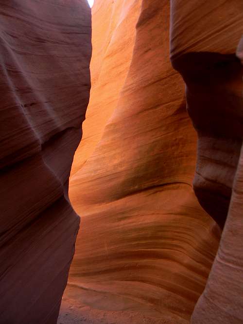
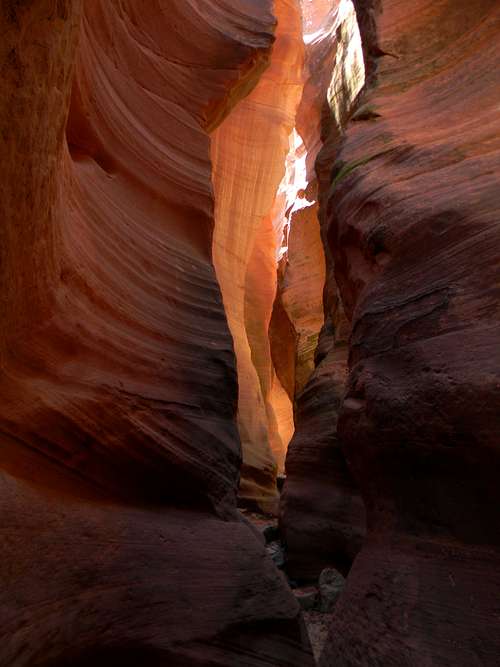
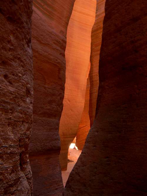
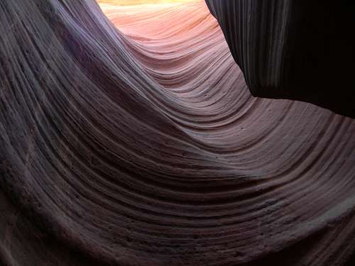
![Upper Red Cave]() Upper Red Cave
Upper Red Cave
![Upper Red Cave]() Upper Red Cave
Upper Red Cave
![Upper Red Cave]() Upper Red Cave
Upper Red CaveOn-line, there's a description of how to make a loop by first heading northeast then northwest from this canyon across sunny, open county, and eventually descend into a narrow wash that empties into Upper Red Cave at its highest reaches. Soon, though, the hike dragged in the unrelenting heat as I followed an old ATV track past numerous crumbly gullies. Then, I arrived at the wash, and am surrounded by beautiful red slickrock with dramatic sandstone domes rising beyond. At the slot canyon, I climbed north then dropped down into the main wash to avoid a rappel. Beyond was one of the most beautiful places that I've ever seen. I walked through the central portion three times to take it all in then eventually returned to the hot sandy washes, roads, and my car.
![Upper Red Cave]() Upper Red Cave
Upper Red Cave![Upper Red Cave]() Upper Red Cave
Upper Red Cave
That evening, I visited the Coral Pink Sand Dunes to see the beauty of a desert sunset on lovely sands, and happened to also see one of the World's rarest animals, a beetle that lives only on a few hundred acres of dunes here.
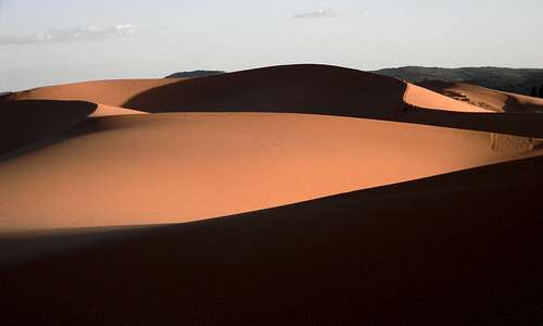
![Coral Pink Sand Dunes]() Coral Pink Sand Dunes
Coral Pink Sand DunesHike to a Whirlwind
After another unsuccessful attempt to get a Wave permit, I decided to take a rest day and then hike the length of Buckskin Gulch the following day. Having seen pictures of the "Toadstools" and the Wahweap Hoodoos at the BLM office I pick these sites to fill the day. The Toadstools are a short trip from the highway and provide a really cool otherworldly experience.
Next, I drove to the Wahweap Hoodoo's trailhead and soon noticed that the path ends after a hundred feet at a ten foot cliff into the wash. Guessing its most likely course, I pushed on with occasional evidence of a trail reassuring me that I was going in the right direction. Maybe I should have had a map. Two hours of 90 something degree heat later, it looked like in the distance there might be a spot that could have a hoodoo. However, planning to do a 26 mile hike the next day, I had doubts about continuing and tiring myself out on what was supposed to be a rest day. Just then, a small dust devil swirled above me at the top of a nearby cliff and I started filming a movie, thrilled by the scene. Soon it dropped down to my level, dramatically intensified, changed course, and words came from a video that I'd shown students once: "There's a tornado and its headed straight at us!". Alone and not knowing the power of these things I ran away as the winds swirled past. That seemed like a fitting ending spot. I'd never before taken a hike to a whirlwind.
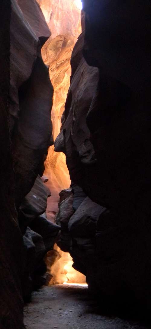
Buckskin Gulch
Some say that this is the longest non technical slot canyon in the World. Leaving from the Wire Pass trailhead at dawn, I soon reached the main canyon and take six hours passing through its depths. Again, progress somehow seemed slower than in years past. There are places of intense beauty, but mostly the canyon felt an endless procession of somber walls with occasional tree trunks wedged across the canyon fifty feet above my head. Again not a place to be in a storm! Reaching the Paria River, I paused a moment and then returned from where I'd come. But water passing through the length of Buckskin Gulch wouldn't have taken a shortcut at Wire Pass, it would have flowed the entire length of the canyon. I knew that I have to ascend the canyon to its top. It was only an extra six miles… In retrospect, this upper portion of the canyon was among the most beautiful country that I'd seen on the entire trip with sweeping red sandstone walls highlit by the setting sun.
![Buckskin Gulch]() Buckskin Gulch
Buckskin Gulch![Buckskin Gulch]() Buckskin Gulch
Buckskin Gulch
The next morning I woke up as group after group came with their permits for the Wave (which is accessed from the same trailhead). Even though it's just a numbers thing, almost all of them were from foreign lands, most Asia. Maybe I'll get there someday…
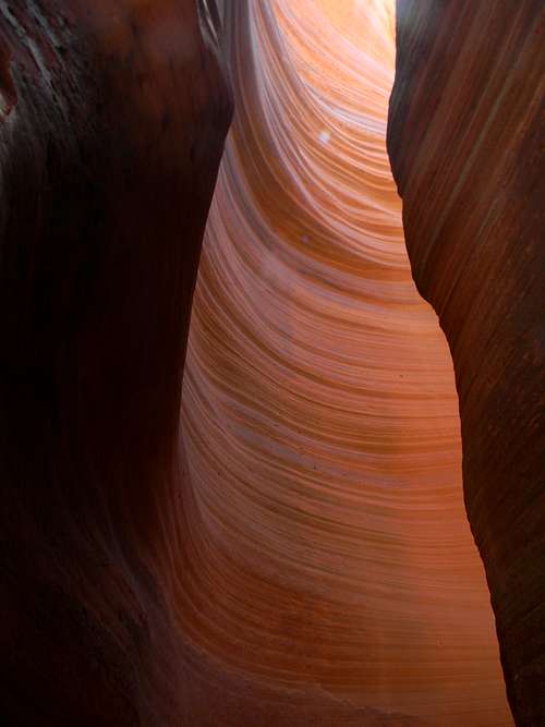
![Upstream from Buckskin Gulch]() Upstream from Buckskin Gulch
Upstream from Buckskin Gulch![Upstream from Buckskin Gulch]() Uprtream from Buckskin Gulch
Uprtream from Buckskin GulchUpper Antelope Canyon
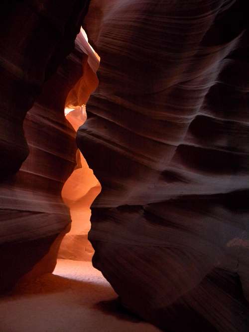
![Upper Antelope Canyon]() Upper Antelope Canyon
Upper Antelope Canyon
I used to think that it was bad that beautiful hikes and places frequently overflowed with visitors. Then, I read Gerry Roach explain that with so many people visiting and reveling at such landscapes, there were more people who would work to protect them. Furthermore, if more money is to be made by preserving a landscape or creature than removing it, people will fight for its retention. Needless to say, the canyon is intensely beautiful.
On the return home, I stopped to climb a few peaks in Colorado, but this isn't a story of lightning or rotten blocks somehow stacked dangerously beyond the angle of repose.


Comments
Post a Comment