Hold up in gimp city
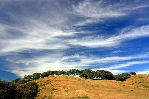
![Driving towards Chileno Valley]() Road to Chileno Valley
Road to Chileno ValleyIf was a rough spring for the old boy. Sporadic periods of work and some down time watching the days go by while sitting on a cushion with left leg out-stretched in front of the computer and TV.
Back in 2001 I suffered a knee injury that appeared to by fairly serious but managed to fix itself over a few week period. Over the years it would re-surface occasionally in the form of the knee joint cramping and unable to straightened my leg fully. I would usually manage to get it back in place momentarily. A few times it took several hours and one time overnight before I could walk again.
One morning in April I woke up and it was jammed again. Only this time it didn't go back in place all day, into the next day and for over 2 weeks I was unable to walk. At first hobbling around with a cane under one arm. Making only one short trip to the store daily to gimp down the aisle for supplies. Went to see my chiropractor friend who said he was sorry he couldn't help me but gave me some crutches. Have always taken mobility for granted but now I know what it's like to be handycapped! Having dreams about my leg staightening only to wake...
With no financial means or health insurance for expensive MRIs etc I did what I could daily to massage and ice it along. Finally one morning it slid into place. The next day I was gratefully getting around with a knee brace. It continued to strengthen and I was doing easy hikes within a few days.
Now I'm poppin' joint support pills etc. wearing a brace and pretty much good to go for half day hikes staying sensitive not to push too hard which is the tendency.
Out to the wilds of west Marin County
Having hiked just about every named hill and small mountain in the county numerous times and not heading for the high country yet I decided to venture out to the rolling terrain of northwest Marin for a change of scene. The area is mostly ranchlands composed of big open valleys and hills where I seldom go.
Taking advantage of the long days this past weekend I spent late Saturday and Sunday afternoons getting to highpoints that offered a new refreshing perspective.
On Saturday I did a small peak named Antonio Mountain and drove back out that way again on Sunday to hike up "Soulajule Ridge" (1,130') next to
Soulajule Reservior.
Antonio Mountain 1,171'
![North from Antonio Mtn.]() North from Antonio Mtn.
North from Antonio Mtn.This is a nice little hill with unobstructed views north and east over expansive Chileno Valley and Petaluma to the mountains of Lake and Sonoma Counties. After hopping a rusty fence I made my way up an old overgrown deserted fireroad to a shoulder and then on up to the dry grass covered summit. It was super windy. Had to hold onto my cap lest it take sudden flight off into the blue.
I also learned a good little lesson I should have learned by now from previous off trail hikes in dry grass.
Foxtail Hell
The beautiful northern Cali hills are a soothing green and often covered with flowers in spring. By early summer depending on the seasonal rain it all dries out and the foxtails in the tall grass are eager to hitch a ride on anything they can.
Nice breathable hi-tech hiking socks and shoes are the perfect host for these extremely insidiuos little bastards! Under the worst conditions in tall dry grass you can easily ruin a pair of socks in a matter of a few hundred yards.
They also love to burrow deep into the insides of those breathable new crosstrainers you just bought. Time, tweezers and the capacity for unspeakable tediousness are the only solution. It's hardly worth the effort with the socks at least.
On Antonio Mountain it looked good at first but at the end of the hike I had paid the price.
On Sunday I was prepared for these devious muthafukkas. I brought old shoes and wore no socks ready to truck up the open slopes of Soulajule Ridge taking on acres of 3 foot hay with a snickering defiance born of hard won experience!
Roar loudly and carry a big stick
![The Three Caballeros from Soulajule Ridge]() 3 Caballeros from Soulajule Ridge
3 Caballeros from Soulajule Ridge![Big cat on Soulajule Ridge]() Big cat on the ridge
Big cat on the ridge![With the big stick]() Big stick in hand, ready to mix it up with the kitty cat
Big stick in hand, ready to mix it up with the kitty cat![Soulajule Ridge]() Looking up Soulajule Ridge
Looking up Soulajule RidgeI was grooving along the top of Soulajule Ridge taking pics when suddenly a hundred yards ahead I spotted a big cat from behind liesurely walking along. It didn't see me and I managed to crank the telephoto and get off a few shots before it disappeared into the brush. Was sure I saw a long tail and without glasses... I put 2 and 2 together and figured it was a mountain lion.
How cool is that! A mountain lion! Way out here is a likely place to see one. Hardly anybody EVER sees these guys. I know of famous nature photographers who have set up light sensitive infrared cameras in the most likely places and only got rabbit, deer and skunk to trip the shutter over a period of several nights.
This large extremely stealthy feline carnivore happened to vanish out of sight right about where I had to pass to get to the best point on the ridge. Knowing what I do about cougars I grabbed a big tree limb and decided to keep on going. Here I was, hiking along shaking the limb and doing my best growling intimidation march just in case this local prowler was extra hungry and had me in it's sights from some unseen vantage point.
The views were grand and the late day light made for some nice shots over Soulajule Reservoir to the south and over Salmon Creek canyon to "The Three Caballeros" (a string of 3 peaks) to the north.
On the way back the setting sun and cirrus clouds from an approaching northern front made for a memorable ending to a beautiful solo afternoon hike.
I must admit I did look back a few times just in case.
Took a different little buttress down to the parking area and wound up bushing down through steep shrubbery, ending at a barbed wire fence above a 4 foot rocky drop. Typical idiocy!
Couldn't wait to get my glasses and check out the shots of the mountain lion!
NOT.....bust...shucks!!
On close inspection the tail was short and striped. It turned out to be a bobcat!
Well, at least it made for some adventure.
By now it was almost 8 PM as I drove back along Salmon Creek on Hicks Valley Road after a thoroughly satisfying day out in the "back country".
![Soulajule Reservior]() Soulajule Reservior from the Ridge
Soulajule Reservior from the Ridge


Comments
Post a Comment