
|
|
Route |
|---|---|
|
|
46.03830°N / 7.66681°E |
|
|
Mountaineering |
|
|
Summer |
|
|
A long day |
|
|
5.5 (YDS) |
|
|
AD |
|
|
III |
|
|
Overview
Like most 4000m peaks in the Valais the Obergabelhorn is a remote mountain. With a long approach and return, not aided by mechanical transportation, it is a serious climbing tour regardless of the route choice.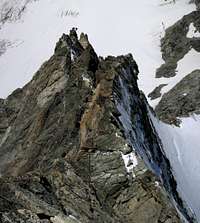
The approach and the climb of the Arbengrat offer some of the best scenery in the Alps, the forbidding north face of the Matterhorn always in front, the Dent d'Herens, the Dent Blanche all the way to the Monte Rosa group are a constant distraction to the climbing action.
The route was first climbed by H. Seymour Hoare, E. Hulton with Johann von Bergen, Joseph Moser and Peter Rubi guides, 23 August 1874.
Getting There
The climb starts from the Arbenbiwak (3224m), an unguarded hut in a lateral valley of the Zmutt valley, on the south side of the mountain. Scenic waterfall
There is another option that shorten the approach somewhat: from Zermatt take the cable way to Schwarzsee, follow the road down to the Zmutt valley, pass by the large waterworks, traverse to the north side of the valley and reach the previous itinerary at the left lateral moraine of the Zmutt glacier.
The Arbenbiwak(15 places) is probably the best bivouac hut in the Alps: it is clean, equipped with photo-voltaic powered lights, a gas stove, pots, plates, cutlery, and a flush toilet. It is a pleasure to drop the required fee (20 CHF) in the box.
 Arben valley Arben valley |  Approach route Approach route | 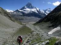 Arbengandegge Arbengandegge |  Arbenbiwak Arbenbiwak |
Route Description
 The route from south
 Sunrise on the Matterhorn
 The WSW ridge from S
 Slanting ledge
Scramble up (W) an easy rock band behind the bivouac. A boulder field leads (N) to the upper Arben Glacier. Plenty of cairns help finding the route in the dark in this section. Proceed shortly (N) on the glacier then turn right up a steeper snow slope (bergshrund) but don't go too far. Start climbing the broken rocks of the south face entering into a gully to your left (or avoid the gully proceeding further at the base of the face and traversing left). At the end of the gully look for a passage left to go over the spur, you should find occasional cairns and signs of passage here if you are on the right track. When you pass over the broad spur the slanting ledge comes into full view. Reach the ledge and follow it to the end. Do not climb the chimney at the end of the ledge but go over a small ridge to your left and traverse to the crest of the Arbengrat at about 3700m.
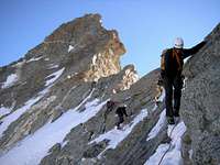
From now on the route is quite obvious, it follows closely the ridge, a few meters down and left on the cold north-west side, or on the crest, except for a few detours to avoid the gendarmes. The first part of the ridge is not very steep and is mixed with snow and some icing. A first step is bypassed easily on the left side. Follow the ridge until you reach the first real obstacle, the Small Gendarme. Go round it on the right side (S) with a short but very exposed traverse with good holds. Return on the ridge and reach the Big Gendarme, more like a ressaut (a big step) than a gendarme. This is bypassed on the left side (NW) following ledges and then up on white slabs and a gully. The Big Gendarme can be climbed directly on the crest, there is a protection bolt halfway up, but the difficulty of this variant does top out at IV+(UIAA) (some nut protection near the crux). Follow the slabs on the left side of the ridge and reach the final ressaut, traverse left and use a system of cracks to return on the ridge. After the final ressaut the ridge eases reaching the West and East summits, nothing but two very fragile cornices hanging in the sky. The climb can be protected easily using long slings on outcrops, Cams (n.1,2) and nuts.
 Lower ridge Lower ridge |  Small gendarme Small gendarme |  Higher ridge Higher ridge |  Nearing the final ressaut Nearing the final ressaut |
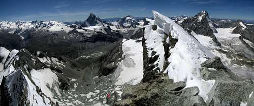 Summit view
Descent
 View from north
 Descent route
If you return by the Arbengrat make sure you don't proceed past the point where you should turn left, over the ridge, to the slanting ledge on the south face, there is no easy return past this point.
If you choose the ENE ridge be prepared for a long return. Abseil the upper part following the crest and reach the snow ridge with big cornices on the right. Follow the ridge on the steep north side (left) to the Kluckerturm, the big gendarme of the ENE ridge, climb it and abseil from the top (best option), or traverse on the left side (N). Another snow ridge takes you to the Wellenkuppe (3903m). The descent from the Wellenkuppe follows the ENE ridge, mostly on its right side (S). First abseil to a saddle on the ridge, follow tracks on the right side on loose and steep debris to a second abseil (right). Continue to a wide saddle overlooking the Trift glacier. On the glacier make an arch NW-N-NE-E-SE to avoid the crevassed area and reach the Rothornhütte. From the hut an easy trail leads to Zermatt.
 Down-climbing the Arbengrat Down-climbing the Arbengrat |  Abseiling the ENE ridge high Abseiling the ENE ridge high |  Abseiling the ENE ridge low Abseiling the ENE ridge low |  ENE ridge ENE ridge |
Difficulty and timing
The Arbengrat is AD, rock climbing is mostly III (UIAA) with some short sections up to III+/IV-(UIAA) between the Small Gendarme and the final ressaut, the rock is very good. Timing can vary between 4 to 8 hours depending on whether you are quick and simul climb, or belay most of the route.The ENE ridge is also AD but the snow ridges are subject to the variable condition of the snow, and the ENE ridge of the Wellenkuppe is a pile of loose debris on steep ground. Return via the ENE ridge to the Rothornhütte should take about 6 hours but can easily take longer, 3 more hours are needed to reach Zermatt.
For most parties it is probably going to be a long day out, unless you are a really fast team plan a second night at the Arbenbiwak or Rothornhütte.