
|
|
Route |
|---|---|
|
|
46.03830°N / 7.66681°E |
|
|
Mountaineering |
|
|
Summer |
|
|
A long day |
|
|
D, IV+ |
|
|
Overview
The Swiss Alpine Club (SAC) guidebook describes the ca. 600m high south face of the Ober Gabelhorn as one of the best rock routes in the area. Although Wallis is known for the poor quality rock that can be found there, the Ober Gabelhorn consists of solid gneiss that is a pleasure to climb. In this it is comparable to its northern neighbours the Zinal Rothorn and the Weisshorn. However, whereas the latter two mountains are climbed over their ridges by all but the best alpinists, the Ober Gabelhorn has an accessible route through its south face that offers a unique experience.That said, it's by no means an easy route. Getting lost in this vast amphitheatre of rock is easy, as a few meters too far left or right will have you off-route and in possibly far more difficult terrain than the IV+ crux sections described in the guidebook. Furthermore, escape will be difficult and the easiest route for descent is still a serious undertaking that will require continued focus and concentration.
The route is climbed from the Arben bivouac, a very well-equipped little hut run by the SAC.
Getting There
The approach to the south face is an enjoyable walk through some of Wallis' most breathtaking scenery and under the shadow of the Matterhorn's imposing north face. From Zermatt, follow the trail to Zmutt and from there head along the track to the Schonbiel hut. As you pass a large waterworks the valley leading to the Ober Gabelhorn will open up on your right and you're treated to your first look at the south face. Take some time to study the route as you continue on.The path follows a morraine ridge and becomes steeper at this point. Follow the well-marked track through boulder strewn fields, snow patches and over glacial rock that has been worn smooth and must be climbed with the aid of the chains attached to them. The final section to the Arben bivouac is an exposed climb up artificial hand and foot holds. You may want to rope up here. Pass the toilet (with running water!) and enjoy what must be one of the best bivouac huts in the Alps.
 Matterhorn as seen during the walk in.
Route Description
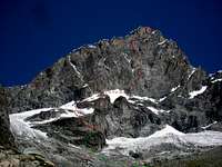 Route Overview
As noted before, the route can be a bit hard to find once you're on it, so it's advisable to study it from a distance first.
The Approach
Behind the bivouac scramble upwards through an easy rock wall that leads to a snow field. This is a good point to tie in and put on your crampons.
Once done, continue upward along the snowfield taking care not to go too far right towards rocks that may look like the start of the route in the dark. They are not. Continue leftwards along them and then go right along a steeper snow field that leads you above those first rocks and towards another section of rocks that do indicate the start of the climbing. At this point parties attempting the Arben Ridge will be able to remove their crampons but to reach the start of the south face another, much steeper, snow field has to be traversed. To get there, scramble through the rocky section below the start of the Arben Ridge route. The snowfield is angled around 45 degrees and is exposed with no room for errors. Crossing it you reach solid ground once more and a good place to remove your crampons and get out the rope.
The Climb
As the guidebook notes, there are two vague ribs coming down across the south face and although the route starts on the left one, it is the right one that you want to be on. Thus, traverse to your right as soon as is practicable. The first few rope lengths of climbing are uncomplicated but soon the difficulty goes up to around III'd grade. Follow the right rib to the top from where a pillar should become visible above and to the left that leads to the distinctive 'Kohlenband' ('Coal Ledge'). Approach it from the bottomright through a short but steep grey coloured cleft (IV) and over steep slabs (III+). Start up the right side of the pillar, cross over to the left side and make your way to its top (III). Traverse the easy Kohlenband until you reach a broad couloir that leads to the summit ridge. Keeping to its lefthand side (the side you approach it from) climb upwards for about 3 ropelengths. At this point you can choose to traverse left and then upwards around a corner to reach the summit directly (IV+) or to continue along the couloir to a point on the ridge just below the summit (III). From there the last few meters to the summit are uncomplicated.
Please note, that we found the climbing more difficult than the grades the guidebook offers. I attribute this to slight deviations from the route that led to more difficult terrain, emphasized by the fact that we found no pegs even though the guidebook mentions them. We did find the 'short grey coloured cleft' the guidebook mentioned and found it well rated at IV. However, the slabby section before that (at the top of the right hand rib) was easily as difficult and very runout and the part leading up to the pillar was definitely not a III. Relative inexperience and some route finding mistakes are most probably the cause but I am curious if anyone else has had the same experience.
The Descent
From the Ober Gabelhorn's summit you can either descend over the north - east ridge and the Wellenkuppe towards the Rothorn hut (AD-) or take the south - westernly Arben ridge (AD III) back towards the bivouac. We chose the latter route. The route is easy to find and consists of continuously exposed downclimbing on solid gneiss alternated with abseils. Only a few abseil stations are bolted, the others consist mostly of webbing thrown around rocky outcrops. Decisions on whether or not to abseil will depend on confidence in downclimbing and conditions. As most of the descent takes place on the northern half of the ridge, some icing can be expected.
Continue downwards along the ridge until you reach a cleft with a distinctive green-coloured block that points back in the direction of the summit. Take care not to proceed past this point!
From the cleft, downclimb along a broad, somewhat vaguely defined couloir until you reach the snowfield over which you walked during the approach. Abseiling is generally not necessary in this part, take care to look for stonemen! From here it is an easy downhill walk back to the hut.
 In the middle of the route.
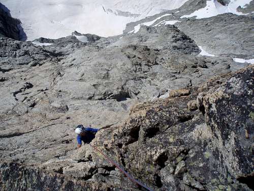 Atop the pillar.
 The 'Kohlenband.'
Essential Gear
* (Single) 50m rope.* Crampons, ice axe.
* 3 or 4 cams (ie: #0.4, #0.75, #1, #2).
* a small selection of nuts.
* plenty of slings (webbing).
* rock climbing shoes unless you are confident that you can climb up to
IV+ / -V (slabs) on your mountaineering boots.
* Plenty of water; it gets pleasantly warm quite quickly!
The Arben bivouac
The Arben bivouac is a very clean and well equipped hut that offers accomodation to about 12 people comfortably. It has an excellent stove with plenty of gas cartridges and comes fully stocked with cutlery, plates etc. Please bring some money to keep it in such great shape.There were some reports of angry guides who harassed friends of ours who 'hadn't booked in advance' but this is nonsense. Both the SAC website and the guides agency in Zermatt confirmed that it is open to all and booking ahead is not possible.
Arben Biwak Website
 The Arben Bivouac
Maps and Guidebooks
Maps:Swisstopo 1:25000 #1327: 'Evolene'
Swisstopo 1:25000 #1347: 'Matterhorn / Monte Cervino' (Details part of the approach)
Swisstopo 1:25000 #1348: 'Zermatt' (Details part of the approach)
Guidebook: Hermann Biner, Hochtouren im Wallis: vom Trient zum Nufenenpass (SAC Verlag 2002).
External Links
An interesting topo diagram can be found under the following link. It too gives a higher rating of several sections than would be apparent from reading the guidebook.Vertical World Topo