
|
|
Trailhead |
|---|---|
|
|
41.23351°N / 111.82076°W |
|
|
Weber |
|
|
Spring, Summer, Fall, Winter |
|
|
5400 ft / 1646 m |
OVERVIEW
 Hiking Trail Near Art Nord
Art Nord Trailhead, located at 41.233514,-111.820763 is a crossroads link to Maples (Snowbasin) Trailhead, Wheeler Canyon (Pineview) Trailhead, and East Fork (Green Pond) Trail. The Old Snowbasin Road also runs directly past it. Art Nord, as a connection to the Great Western Trail, links the Maples section to the Wheeler Canyon section.
The trailhead, in and of itself, is of more interest to mountain bikers than people attempting any of the area’s mountains on foot. The nearest summits are Sardine Peak and Mount Ogden ; both are 3+ miles to the south. A much closer jumping off point for either peak is the Snowbasin Resort. Mountain bikers, however, move much faster than hikers and the trails in the area are scenic, non-technical routes. Some bikers use Art Nord as a starting point for a 10-20 mile mountain loop in the area. Various routes will take a biker past Sardine Peak, the Ogden Overlook , Mt. Ogden, Green Pond, Strawberry Peak and/or any combination thereof. Previously, the Snowbasin Resort even offered Art Nord to Snowbasin shuttle service…check their website for availability. Mountain bikers can also go north from Art Nord through Icebox Canyon or down to Pineview Reservoir through Wheeler Canyon (about 3 miles on an old gravel road) to Wheeler Trailhead.
 Old Snowbasin Road right next to trail head...start your Nordic Ski here!
In winter, Art Nord gets high use from Nordic Skiers. The same trails mountain bikers use in the summer are good for cross-country skiing in winter too. Like everywhere else in Utah, there is usually plenty of virgin snow come late-December. The Green Pond Trail heading north east from Art Nord is a reasonably gentle grade but ungroomed. The Old Snowbasin Road immediately adjacent to Art Nord Trailhead is closed to traffic and groomed all the way up to Snowbasin resort. This 3 mile road ski is a hard trip up and a nice glide back to the trailhead with 780 feet of elevation gain/loss. The Snowbasin Road route links into several other Nordic trails near Snowbasin Resort for a total of 15 miles of groomed trails. There is no charge for Nordic skiing in the area.
The area is great for general hiking and snowshoeing (3-5 mile hikes without crazy/steep trails). It’s perfect for getting the little guys out on nature walks and/or romping through the snow. The Icebox Canyon loop is just a couple of miles long but features some pretty hiking/snowshoe scenery.
Art Nord trailhead was named, you guessed it, after Art Nord who was a Forest Service employee in the mid-1900s. He was instrumental in making the Snowbasin/Forest Service deal that saved the area’s watershed and rehabilitated the local landscape. A monument with background history is just north of the trailhead.
GETTING THERE
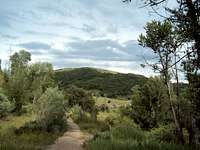
 East Fork Trail near Art Nord
From I-15 on the north side of Ogden, take the 12th street exit (#347) and head east. The road will continue into Ogden Canyon (12th Street turns into Highway 39). At the mouth of the Canyon as you begin on the windy road, you’ll see a waterfall that almost always has kids, tourists and random cars. Don’t be distracted as the pretty waterfall is actually runoff from the city’s aqueduct. Continue east on Highway 39 through the canyon. As the road exits the canyon, you’ll pass Wheeler Canyon Trailhead on the right and Pineview reservoir will be on the left. Follow Highway 49 keeping an eye out for the Old Snowbasin Road sign—it’s a small sign. Take a right onto Highway 226 (Old Snowbasin Road) for about 3.5 miles. Art Nord Drive Trailhead is on the right.
TRAILHEAD INFO
The trailhead has a large parking lot with around a 10-car capacity. There are outhouse style bathroom facilities available. A small Info Kiosk has a poster map of the area and some historical info about the trail. Near the parking lot are several informational plaques describing different forest management aspects. There is also a small monument to Art Nord a short way down on the Wheeler CanyonCamping and Red Tape
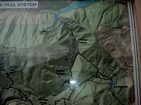 Art Nord Trail map
CAMPING
There isn’t any formal camping in the immediate area. Signs at the trailhead say it is prohibited. Despite that, there are several impromptu fire rings near the parking lot. The area around the trailhead is a mix of private (but accessible) land and USFS. If you are thinking about camping in the area, check a map prior.
RED TAPE:
The signs at the parking lot say the area is closed from 10pm-6am. Most likely, they are discouraging camping, use of the area as a make-out point, and/or gangs of unruly youths playing loud rock-n-roll music while consuming illicit pharmaceuticals.
Horses are allowed on most area trails, dogs and mountain bikes are allowed on all.