
|
|
Trailhead |
|---|---|
|
|
41.19703°N / 111.93777°W |
|
|
Weber |
|
|
Spring, Summer, Fall, Winter |
|
|
4800 ft / 1463 m |
OVERVIEW

Strong's Canyon Trail

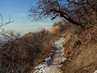
Trail Near 36th Street Trailhead
36th Street Trailhead, located at the top of 36th Street in Ogden, is a popular trailhead for accessing several area hiking trails. While it isn’t the best trailhead for starting attempts on area summits, it is a convenient link for general hiking in the area. The lower Strong’s Canyon Trail has recently undergone construction with the installation of new water tanks and has been improved/re-routed. The lower portion just out of the trail head has been re-routed where they built the tanks and there are several new trails that have been built for mountain bikes and/or hiking.
The Trailhead accesses three area trails:
Foothill Loop: Jogger/mountain bike trail along the golf course
Strong’s Canyon: A ½ mile trail through the forest and up the canyon; links to Bonneville Shoreline Trail
Bonneville Shoreline Trail: A 90-mile trail running along the Wasatch Front west face
You can reach several interesting objectives from the 36th Street Trailhead including Waterfall, Taylor, and Beus Canyons.
Waterfall Canyon: Hike up Strong Canyon trail to its end ~1/2 mile. There is a small footbridge and a sign. Go North (left...not across the bridge) on the Bonneville Shoreline Trail for ~1.2 miles.
Taylor Canyon: Hike up Strong Canyon trail to its end ~1/2 mile. There is a small footbridge and a sign. Go North (left...not across the bridge) on the Bonneville Shoreline Trail for ~1.2 miles. Cross the small foot bridge next to Waterfall Canyon Trail and continue on the Bonneville Shoreline Trail for another mile.
Beus Canyon: Hike up Strong Canyon trail to its end ~1/2 mile. There is a small footbridge and a sign. Go South across the bridge (Right) on the Bonneville Shoreline Trail for ~1.2 miles.
The Strong Canyon area is a popular area for evening hiking and mountain biking. During the winter/late fall the trails are beaten down but the Strong Canyon trail does get a fair amount of ice—Yak Tracks/traction devices are recommended. During the summer, the area is crowded with dog-walkers, hiker groups and mountain bikers which makes it harder to enjoy.
There aren’t any formal camping sites in the general area, although once up the canyons there are a couple of spots for primitive camping. During the summer, fires are prohibited on the west faces of the hills due to the forest fire threat. The area still gets a big brush fire every couple of years, so be careful. Water resupply is possible in the Strong Canyon, Waterfall Canyon and Taylor Canyon streams.
THE TRAILHEAD

Bonneville Shoreline Trail
The trailhead has a small parking lot with around a 10-car capacity. No water or bathroom facilities are available. A sign warns you about securing or hiding your valuables; there’s broken window glass as evidence some cars have been broken into. No motor vehicles are allowed on the trails but watch out for mountain bikes especially on the exercise trail and up on the Bonneville Shoreline trail. The trailhead is rarely full in the winter but gets near capacity on summer evenings. Dogs are allowed on all trails but please bring a pooper-scooper. The Info Kiosk has a poster map of the area, outlines the ongoing construction and has some historical info about the trail.
GETTING THERE AND RED TAPE
Bonneville Shoreline Trail
GETTING THERE
36th Street Trailhead is located at 41.197032,-111.937771.
From I-15, take exit 341 and proceed east for .4 miles. Stay right at the fork and continue toward Weber State for 1.2 miles. Turn right on Washington Blvd and drive south for .7 miles. Turn left on 36th Street; trailhead will be about .4 miles on the left.
RED TAPE:
The hikes in the area are on USFS land, no fees. Dogs are allowed. Because it’s USFS land be sure to abide by the usual regulations inherent to Government property.
TERRAIN AND WILDLIFE
The area around the trailhead has the usual Utah wildlife including Deer, Elk, Rabbits, squirrels, and the like. Like everywhere else in Utah, watch out for rattlesnakes. The west face of the Wasatch Mountains are hot and dry in the summer and covered with sage brush and dry grasses. The canyons are mostly made up of Gambel Oak, Canyon Maple, and Water Birch forests. The area gets lots of snow during the winter, the lower trails are pretty well beaten down but still are pretty entertaining places to snowshoe.HELPFUL WEBSITES
www.facebook.com/MountOgdenViaFerratawww.ogden-ut.com/hiking.html
www.utah.com/ogden/hiking_trails.htm
www.localhikes.com/Hikes/Waterfall_Canyon_7160.asp
www.weberpathways.org