
|
|
Trailhead |
|---|---|
|
|
41.32027°N / 111.89916°W |
|
|
Weber |
|
|
Spring, Summer, Fall, Winter |
|
|
6200 ft / 1890 m |
Overview
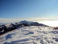
Traverse on North Skyline

Monument with local historical info
The North Ogden Divide Trailhead, at the top of the North Ogden Divide Canyon Road is a USFS trailhead and serves as the launch point for 5 area summits. It is a well maintained but not an overly crowded trailhead. Normally there are only a couple of cars in the lot except on weekends. The North Canyon Road links North Ogden from the West to Liberty and Pineview Reservoir to the East.
The North Ogden Divide Trailhead is a trailhead for all seasons linking the South Skyline, North Skyline and Pioneer Trails. North and South Skyline are part of the Great Western Trail system (a 4,500 mile adventure right up the Mountain States!). There are 5 summits in the area; Ben Lomond (8.2 miles on North Skyline), Willard Peak (11.5 miles on North Skyline) Chilly Peak (4.5 miles on North Skyline), Eyrie 8136 (3.1 miles on South Skyline) and Lewis Peak (5.5 miles on South Skyline). In addition to the major peaks, there are a bunch of lesser, but still worthy highpoints like 8246 (3.5 miles on North Skyline and 8110 (2.9 miles on South Skyline). Pioneer trail goes east/west toward North Ogden and Liberty. I have never hiked it, but it appears to be shady most of the way. Pioneer Trail links with the Bonneville Shoreline Trail.
The area trails are unique in that they are open to dirt bikes, snowmobiles and ATVs as well as horses, mountain bikes and hikers. Both North and South Skyline trails are open in the winter (although the parking lot is blocked with snow) and are good for snowshoeing...cross country skiing would require some skill.
There isn’t a readily available water resupply point on either the North or South Skyline, so you need to bring your own. Both trails are exposed to the sun for most of the hikes and it gets hot.
There aren’t any formal camping sites in the general area, although there are plenty of spots for primitive camping. Use established fire rings whenever possible and practice “leave no trace” camping. Once again, lack of water in the area could prove to be a limiting factor.
The area around the trailhead is loaded with wildlife including Moose, Deer, Elk, Mountain Goats, Rabbits, squirrels, and the like. Both eagles and vultures soar above the ridgelines. The area is also a pretty good bird watching area. Bugs are plentiful but mostly of the non-biting-but-really-annoying variety. Like everywhere else in Utah, watch out for rattlesnakes.
THE TRAILHEAD

South Skyline Trail from Trailhead
The trailhead doesn't have a water source but it does have an outhouse style bathroom facility.
There is parking for about 30 vehicles and can accommodate horse/motor cycle trailers.
The Info Kiosk has a poster map of the area and safety info. There is a monument with general historical info about the trail and the area.
GETTING THERE

North Skyline trail

Sign in front of trailhead
From I-15, Take exit 344 (the 12th Street exit). Drive East on 12th Street for 2 miles. Turn North onto Washington and drive toward Ben Lomond for about 3.5 miles. Turn right onto 3100N and continue up N. Ogden Canyon Road. The trailhead will be on the top (about 3 miles) on your right. If you start heading down, you've gone too far. It’s big, you can’t miss it!
WEBSITES
www.utahmountainbiking.com/trails/skylin-n.htm
www.fs.fed.us/wcnf/unit/ogden/skyline.htm
www.weberpathways.org/trails_display.asp?ID=4
www.trimbleoutdoors.com/ViewTrip/213041
RED TAPE
RED TAPE
The trails are all on USFS land and there are no associated fees. As with all federal lands, there are a herd of federal regulations which subject violators to fines and/or imprisonment. As such:
• Campgrounds and other recreation sites can be used only for recreation
purposes. Permanent use or use as a principal residence without
authorization is not allowed.
• Remove all personal property and trash when leaving.
• Do not carve, chop, cut, or damage any live trees.
• Preserve and protect your National Forests by leaving natural areas the
way you find them.
• Throw all garbage and litter in containers provided for this purpose, or
carry it out with you.
•Motorized vehicles are restricted to designated roads, trails, and areas.
•When operating any kind of vehicle, do not damage the land or vegetation,
or disturb wildlife. Do not drive on unpaved roads or trails when they
are wet or muddy.
• Saddle or pack animals are allowed in recreation sites only where
authorized by posted instructions.
• No fighting or boisterous behavior.
• Keep noise at a reasonable level. Please be considerate of fellow
visitors.
• A permit is required for operating a public address system in or near a
campsite, developed recreation site, or over a body of water.
• Recreational use of pharmaceuticals on Federal Lands is frowned upon