Introduction
This is a brief trip report album to describe our trip on March 13-21 2010 to Bandelier National Monument, Carlsbad National Park and Guadalupe National Park. The idea is to let the photos tell the story.
It was a good trip and we visited some nice ruins, beautiful caves, climbed several peaks and went on several hikes.
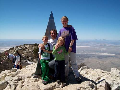
![Summit shot (TR purposes only)]() This is the climbing team on the summit of Guadalupe Peak.
This is the climbing team on the summit of Guadalupe Peak.March 13: Alcove House [Ceremonial Cave]/Upper Lower Falls [Frijoles Canyon] (New Mexico)
Today Shaylee, Kessler, Kimberly and I stopped at Bandelier National Monument on our way to Carlsbad Caverns. First we hiked the loop to the Ceremonial Cave/Alcove House in Frijoles Canyon. The cliffs of Frijoles Canyon are pock marked with many caves that were used by the ancestral pueblo Indians hundreds (to thousands) of years ago. The kids liked climbing into the caves, but their favorite part was climbing up the long wooden ladders to reach the caves.
In the afternoon we still had time, so we hiked to the waterfalls in lower Frijoles Canyon. It was a great hike and necessary since we had a long car drive ahead of us.
![Bandelier National Monument]() These are some of the wierd cliff in Bandelier National Monument. Notice the ancient ruins at the base of the cliff.
These are some of the wierd cliff in Bandelier National Monument. Notice the ancient ruins at the base of the cliff.![Cave houses]() Climbing into one of the ancient cave houses in Bandelier National Monument.
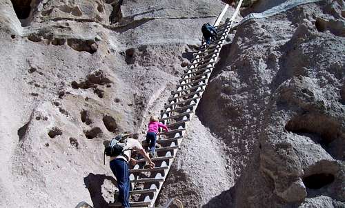
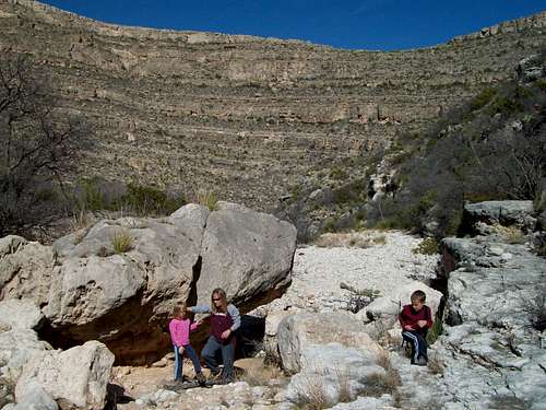
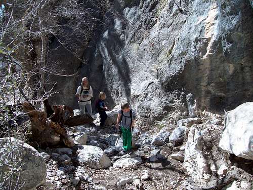
Climbing into one of the ancient cave houses in Bandelier National Monument.![Route to Ceremonial Cave]() Me, Shaylee and Kessler on part of the route to Ceremonial Cave in Bandelier National Monument.
Me, Shaylee and Kessler on part of the route to Ceremonial Cave in Bandelier National Monument.![Ceremonial Cave]() Climbing into the ancient Alcove House in Ceremonial Cave.
Climbing into the ancient Alcove House in Ceremonial Cave.![Route down]() This is the route down from Ceremonial Cave.
This is the route down from Ceremonial Cave.March 14: Kings Palace/Rattlesnake Canyon (New Mexico)
Today we had a reservation at Carlsbad Caverns for a tour of the King’s Palace. The original plan was to visit the rest of the cave after the King’s Palace, but when we saw the weather forecast we decided to save the rest of the cave for the next day.
The walk through King’s Palace was a good one with lots of fantastic formations, but Kessler missed the wild caves that he is more used to exploring. It was still a fantastic experience.
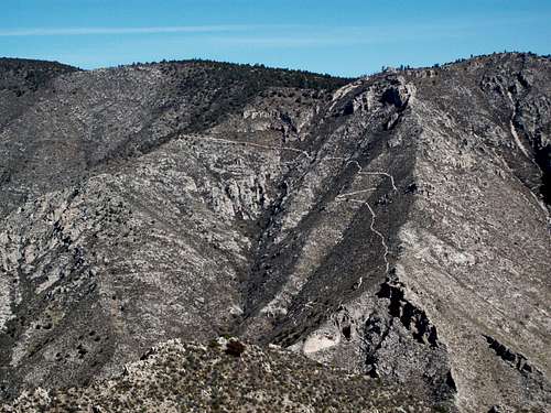
After walking through the King’s Palace with the ranger we returned to the surface and drove over to Rattlesnake Canyon. We didn’t start our hike until 2:15 PM, but I thought that the kids, wife and I could complete the six mile loop in time to be out of the park by 6:00 PM when the NPS locks the gate. Dropping down into Rattlesnake Canyon was easy, but going up Rattlesnake Canyon to the Guadalupe Ridge was more rugged and slower than I expected. By the time we made it to the Guadalupe Ridge it was obvious that we wouldn’t make it out of the park before the gate was locked. We hurried down the Guadalupe Ridge, but stopped briefly to view two javelinas which were next to the trail. They were just standing there at first, but by the time I got my camera out they skittered away.
We ended up at the NPS gate about 20 minutes after it was locked. I was just going to leave the vehicle there and walk to the campground and pick up the vehicle the next day, but someone else was also locked in and they called the rangers to come and let us out.
![King s Palace]() This is part of the King's Palace.
This is part of the King's Palace.![Rattlesnake descent]() This is the beginning of the descent into Rattlesnake Canyon.
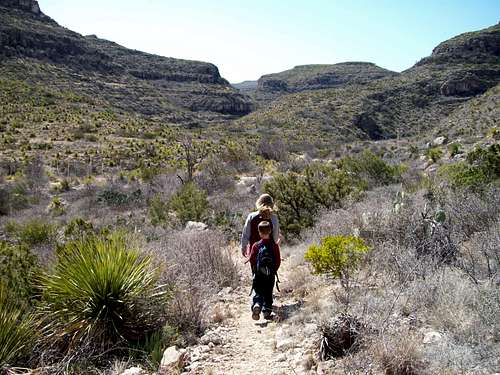
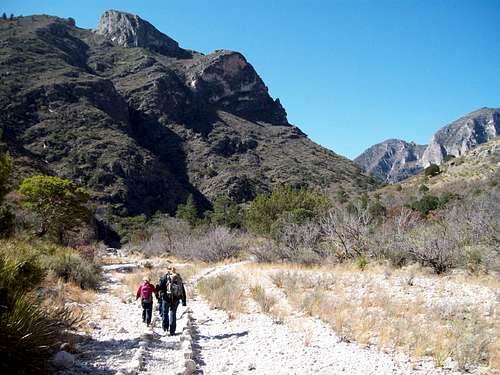
This is the beginning of the descent into Rattlesnake Canyon.![Rattlesnake Canyon]() This is part of our route through Rattlesnake Canyon.
This is part of our route through Rattlesnake Canyon.![Rattlesnake Canyon to Guadalupe Ridge]() This is part of the Rattlesnake Canyon to Guadalupe Ridge Route.
This is part of the Rattlesnake Canyon to Guadalupe Ridge Route.![Rattlesnake Canyon]() This is part of our route through Rattlesnake Canyon.
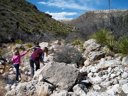
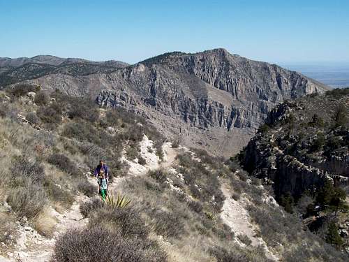
This is part of our route through Rattlesnake Canyon.![Rattlesnake Canyon]() Rattlesnake Canyon in Carlsbad Caverns National Park.
Rattlesnake Canyon in Carlsbad Caverns National Park.![Route]() This is part of our route up Rattlesnake Canyon to reach the Guadalupe Ridge.
This is part of our route up Rattlesnake Canyon to reach the Guadalupe Ridge.![Looking down Rattlesnake Canyon]() Looking down Rattlesnake Canyon from the Guadalupe Ridge.
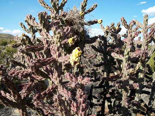
Looking down Rattlesnake Canyon from the Guadalupe Ridge.![Cholla]() A blooming cholla on the Guadalupe Ridge.
A blooming cholla on the Guadalupe Ridge.March 15: Natural Entrance/Big Room (New Mexico)
Last night was stormy and very windy so we didn’t get much sleep in the tent. It was constantly raining which made it an excellent day to spend underground. We took a shuttle up to Carlsbad Caverns and then walked over to the Natural Entrance before dropping in. We dropped down, down, down into the depths of the cave, taking time to take photos and to look at all the formations. After walking all the way from the Natural Entrance to the bottom of the cave, we took the loop route around the big room which is the biggest underground “room” known in North America.
By the time we exited the cave, it was still raining hard. Hiking underground is the way to go on a cold and rainy day!
![Natural Entrance]() This is the Natural Entrance of Carlsbad Caverns as seen on March 15 2010.
This is the Natural Entrance of Carlsbad Caverns as seen on March 15 2010.![Big Room]() This is part of the Big Room.
This is part of the Big Room.![Formations]() These are some of the formations in the Big Room in Carlsbad Caverns on March 14 2010. Kessler Patterson photo.
These are some of the formations in the Big Room in Carlsbad Caverns on March 14 2010. Kessler Patterson photo.![Beautiful formations]() These are some of the formations in the Big Room.. Kessler Patterson photo.
These are some of the formations in the Big Room.. Kessler Patterson photo.![Carlsbad]() Formations in the Big Room in Carlsbad Caverns. Kessler Patterson photo.
Formations in the Big Room in Carlsbad Caverns. Kessler Patterson photo.![Cave formations]() Formation in the Big Room in Carlsbad Caverns. Kessler Patterson photo.
Formation in the Big Room in Carlsbad Caverns. Kessler Patterson photo.![Monster s mouth]() These are some of the formations in the Big Room. The kids thought it looked like a monster's mouth. Kessler Patterson photo.
These are some of the formations in the Big Room. The kids thought it looked like a monster's mouth. Kessler Patterson photo.March 16: El Capitan Trail (Texas)
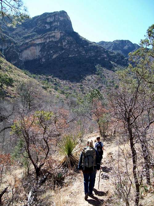
Today was our first day in Guadalupe National Park, but it was really windy so Kessler, Shaylee, Kimberly and I decided to forego climbing any peaks. Instead we opted for the El Capitan Trail which follows a route from Pine Springs to the base of El Capitan rather than climbing it.
It was windy, but the wind wasn’t extreme so we made our way along the trail to Guadalupe Canyon while taking many photographs of El Capitan along the way. We then descended Guadalupe Canyon a short ways to where the trail climbed up to the base of the big cliffs of El Capitan. After eating lunch we returned to the trailhead. It was a great route even though we didn’t get to climb a peak.
Since there was still time available we also hiked the Pinery Trail before calling it a day.
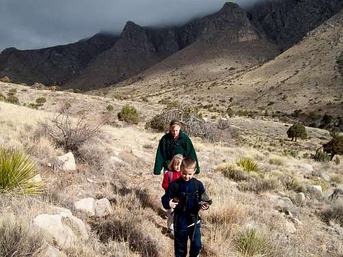
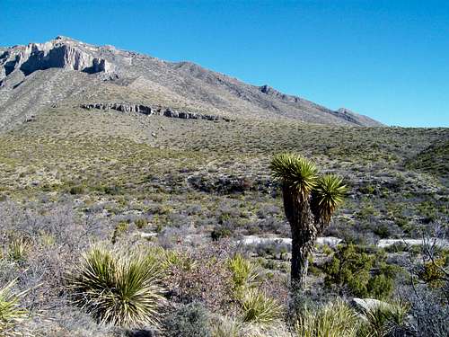
![Clouds, wind and cool weather]() Our trip on March 16 to El Capitan started with cloudy skies and very windy conditions. Hunter Peak looms in the clouds in the background.
Our trip on March 16 to El Capitan started with cloudy skies and very windy conditions. Hunter Peak looms in the clouds in the background.![El Capitan]() Shaylee and Kessler approaching the looming El Capitan.
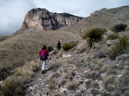
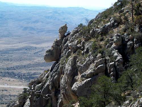
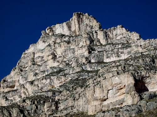
Shaylee and Kessler approaching the looming El Capitan.![El Capitan]() El Capitan, perhaps the most spectacular peak in the Guadalupe Mountains.
El Capitan, perhaps the most spectacular peak in the Guadalupe Mountains.![El Capitan]() This is the towering El Capitan.
This is the towering El Capitan.![Hunter Peak]() Returning from El Capitan on March 16 2010. The weather has improved and Hunter Peak is clearly visible in the background.
Returning from El Capitan on March 16 2010. The weather has improved and Hunter Peak is clearly visible in the background.March 17: Guadalupe Peak (Texas)
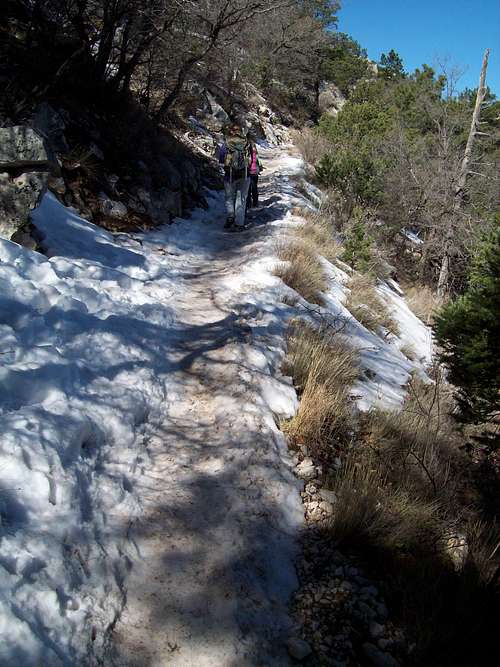
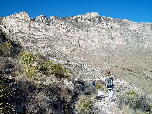
There wasn’t much wind this morning, so it was time to climb Guadalupe Peak, the highest mountain in Texas! Shaylee, Kessler, Kimberly and I left in the morning and made our way steadily up the peak. About 2/3 of the way up there was quite a bit of snow and ice along the trail. The snowfields near the summit were the hardest part of the climb and I wished I had brought and ice axe or crampons for the peak in order to help the kids up.
After enjoying the summit and chatting with a few fellow climbers we headed down the mountain. All of us had a good time and it was great to climb the mountain in perfect weather.
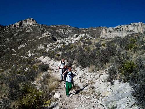
![Starting up]() We have just started (March 17 2010) the long climb to the summit of Gualalupe Peak, the highest mountain in Texas. Hunter Peak is in the background.
We have just started (March 17 2010) the long climb to the summit of Gualalupe Peak, the highest mountain in Texas. Hunter Peak is in the background.![1/3 of the way up]() This is part of the trail 1/3 of the way up Guadalupe Peak.
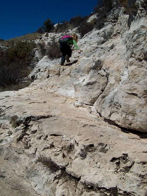
This is part of the trail 1/3 of the way up Guadalupe Peak.![Cliff section]() This is what is known as the cliff section of the trail up Guadalupe Peak.
This is what is known as the cliff section of the trail up Guadalupe Peak.![Getting close!]() Getting close to the summit of Guadalupe Peak.
Getting close to the summit of Guadalupe Peak.![Icy trails]() Some of the sections of the trail up Guadalupe Peak were quite icy and slick. I actually wished I brought an ice axe or crampons to help the others across.
Some of the sections of the trail up Guadalupe Peak were quite icy and slick. I actually wished I brought an ice axe or crampons to help the others across.![Tejas Trail]() This is part of the Tejas Trail as seen on March 17 2010 from Guadalupe Peak. The next day we would use the Tejas Trail to descend Hunter Peak.
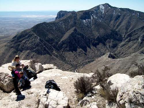
This is part of the Tejas Trail as seen on March 17 2010 from Guadalupe Peak. The next day we would use the Tejas Trail to descend Hunter Peak.![Guadalupe Peak]() The summit of Guadalupe Peak as seen on March 17 2010.
The summit of Guadalupe Peak as seen on March 17 2010.![El Capitan]() The "backside" of El Capitan as viewed from near the summit of Guadalupe Peak.
The "backside" of El Capitan as viewed from near the summit of Guadalupe Peak.![Steepest section]() This is the steepest section of the Guadalupe Peak climb and is located just below the summit.
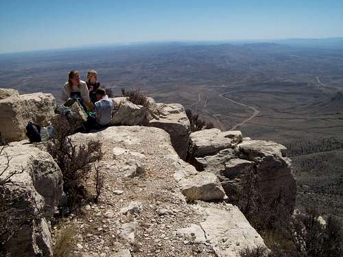
This is the steepest section of the Guadalupe Peak climb and is located just below the summit.![Summit]() This is the summit of Guadalupe Peak as seen on March 17 2010. There were several other people on the summit since it was spring break for Texas (as well as for us).
This is the summit of Guadalupe Peak as seen on March 17 2010. There were several other people on the summit since it was spring break for Texas (as well as for us).![Descending]() Descending Guadalupe Peak on March 17 2010. El Capitan is on the right.
Descending Guadalupe Peak on March 17 2010. El Capitan is on the right.March 18: Hunter Peak (Texas)
We (Shaylee, Kessler, Kim and I) awoke to perfect weather with only a light breeze and clear skies, so it was time to attempt to climb Hunter Peak which is said to have the best views in Texas. We chose to do the loop hike going up Bear Canyon and down the Tejas Trail. Bear Canyon has a nasty reputation as being very steep and difficult and we were a little concerned that it would be challenging for our five year old daughter. We found the trail to be fairly steep, but it wasn’t a problem at all and the rumors of it being difficult were mostly unfounded. It was a slow climb (at least slower than Guadalupe Peak), but we made it up to the summit of Hunter Peak without any problems. The peak did have some grand views and we took a long lunch on the summit.
We returned down the peak via the Bowl and Tejas Trails, but found that we had to cross a fair amount of snow on the rim of The Bowel. After reaching the Tejas Trail it was just a long walk back to the campground. Hunter Peak took us quite a bit longer to climb than Guadalupe did and we got back to camp not that long before sunset.
![Hunter Peak via Bear Canyon]() This is the lower section of the Bear Canyon Trail which we used to climb Hunter Peak on March 18 2010.
This is the lower section of the Bear Canyon Trail which we used to climb Hunter Peak on March 18 2010.![Bear Canyon Trail]() Part of the rugged Bear Canyon Trail which we used to climb Hunter Peak.
Part of the rugged Bear Canyon Trail which we used to climb Hunter Peak.![Rock formations]() Some of the rock formations seen along the Bear Canyon route to Hunter Peak.
Some of the rock formations seen along the Bear Canyon route to Hunter Peak.![Bear Canyon route]() The upper part of the Bear Canyon route up Hunter Peak.
The upper part of the Bear Canyon route up Hunter Peak.![Guadalupe from Hunter]() Guadalupe Peak as seen from the summit of Hunter Peak.
Guadalupe Peak as seen from the summit of Hunter Peak.![Summit of Hunter Peak]() Lunch on the summit of Hunter Peak on March 18 2010.
Lunch on the summit of Hunter Peak on March 18 2010.![Descent]() Descending Hunter Peak.
Descending Hunter Peak.![Descending Hunter Peak]() Descending Hunter Peak.
Descending Hunter Peak.![Sub-horn]() One of the sub-horns of Hunter Peak. The lower slopes of Guadalupe Peak are in the background.
One of the sub-horns of Hunter Peak. The lower slopes of Guadalupe Peak are in the background.![Hunter Peak descent]() Descending Hunter Peak
Descending Hunter Peak![Hunter Peak]() Hunter Peak, which we just climbed towers in the background.
Hunter Peak, which we just climbed towers in the background.![The love cactus......]() A double heart prickly pear cactus on Hunter Peak.
A double heart prickly pear cactus on Hunter Peak.![Hunter Peak]() A double heart prickly pear cactus on Hunter Peak.
A double heart prickly pear cactus on Hunter Peak.March 19: McKittrick Canyon (Texas)
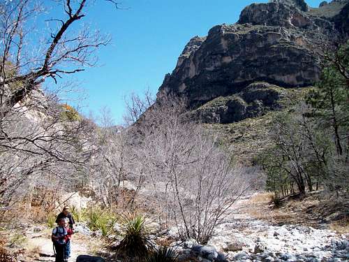
Shaylee, Kessler, Kimberly and I awoke to high winds so we headed for McKittrick Canyon. We thought that the wind wouldn’t be as bad in the canyon since it is more heavily vegetated than the slopes of the mountains. McKittrick Canyon is also known as the most beautiful spot in Texas.
We hiked up the canyon, but it was really windy in the open areas. Even so the kids actually enjoyed being blown around by the wind and were quite amused by it. We stopped and checked out the historic Pratt Cabin before continuing up the trail to the Grotto which is sort of an above ground cave, complete with formations. After taking a very long lunch and relaxing, we headed back to the trailhead in strong winds.
![Mouth of McKittrick Canyon]() This is the mouth of McKittrick Canyon in the Guadalupe Mountains.
This is the mouth of McKittrick Canyon in the Guadalupe Mountains.![McKittrick Canyon]() Hiking McKittrick Canyon in the Guadalupe Mountains.
Hiking McKittrick Canyon in the Guadalupe Mountains.![Steam Crossing]() Crossing the stream in McKittrick Canyon.
Crossing the stream in McKittrick Canyon.![McKittrick Canyon]() Shaylee hiking in McKittrick Canyon in the Guadalupe Mountains.
Shaylee hiking in McKittrick Canyon in the Guadalupe Mountains.![McKittrick Canyon]() Hiking McKittrick Canyon.
Hiking McKittrick Canyon.![McKittrick Canyon]() Hiking McKittrick Canyon.
Hiking McKittrick Canyon.![McKittrick Canyon]() McKittrick Canyon in the Guadalupe Mountains.
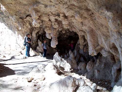
McKittrick Canyon in the Guadalupe Mountains.![The Grotto]() The Grotto is sort of like an above ground cave and is located in McKittrick Canyon/Guadalupe Mountains.
The Grotto is sort of like an above ground cave and is located in McKittrick Canyon/Guadalupe Mountains.![Craggy Peak]() This craggy peak rises directly above McKittrick Canyon said to be the most beautiful spot in Texas.
This craggy peak rises directly above McKittrick Canyon said to be the most beautiful spot in Texas.March 20: Chihuahua Nature Trail (New Mexico)
This morning, Shaylee, Kessler, Kim and I awoke to strong winds and ……….snow! In Texas for spring break! It was windy all through the night as well so Kim and I didn’t get so much sleep. I had actually brought our four season tent and I was very glad I did because some of the other tents in the campground didn’t fare so well. The sky had cleared by morning and it was 24F degrees with an estimated 35-40 mph winds. We had planned to hike Devils Hall, but we didn’t bring enough clothing for near 0F wind chills so we packed up camp and headed back towards Carlsbad.
It was still cold and very windy at Carlsbad, so the only hiking we did was the Chihuahua Desert Nature Trail. Since we didn’t bring our heavy parkas, gloves and hats for this trip (we did bring coats) we decided to call it a day hiking wise. We actually ended up visiting the Alien Museum in Roswell before heading north to Santa Fe.
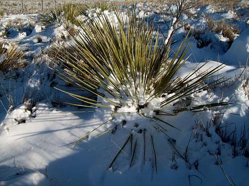
![Snow on the Yucca]() Snow on the Yuccas in Texas on March 20 2010.
Snow on the Yuccas in Texas on March 20 2010.March 21: Tsankawi (New Mexico)
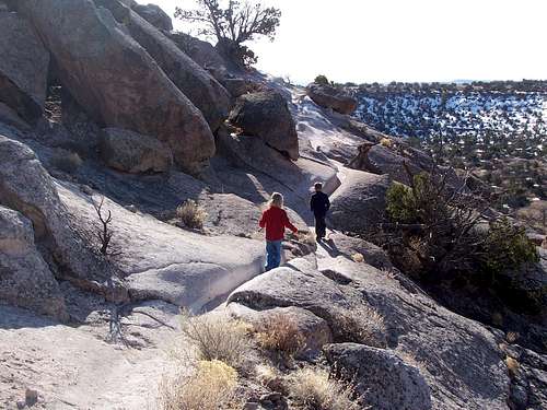
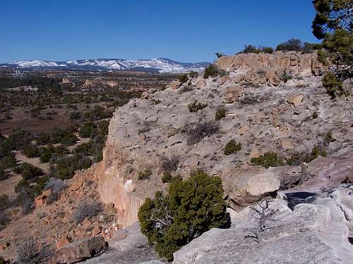
It was chilly, but sunny in the morning near Santa Fe. There was some fresh snow around, but not too much so we drove north to the Tsankawi Ruins Trailhead in Bandelier National Monument.
We completed the loop hike around the ruins and petroglyphs while climbing over the top of the mesa in the process. The kids really enjoyed the wooden ladders leading up and over the cliffs. There was only a little snow on the trail and it was a great little hike to take before taking the long drive back to Craig Colorado.
![Alien?]() This ancient petroglyph at Tsankawi seems to look like an alien. Is it a coincidence that Roswell is in the same state?
This ancient petroglyph at Tsankawi seems to look like an alien. Is it a coincidence that Roswell is in the same state?![Tsankawi]() Kessler and Shaylee on part of the route to Tsankawi.
Kessler and Shaylee on part of the route to Tsankawi.![Trail to summit]() This is part of the trail to the summit of Tsankawi (New Mexico) on March 21 2010.
This is part of the trail to the summit of Tsankawi (New Mexico) on March 21 2010.![Ancient rock steps]() These are some of the ancient rock steps used by the ancient native americans hundreds of years ago to reach the summit of Tsankawi. Now days, wooden ladders are used.
These are some of the ancient rock steps used by the ancient native americans hundreds of years ago to reach the summit of Tsankawi. Now days, wooden ladders are used.![Near the top]() Near the top of Tsankawi
Near the top of Tsankawi


Comments
Post a Comment