Months away from the summer desert heat, I pictured myself thoroughly enjoying a pleasant week of hiking and climbing the cool and arid mountains of West Texas, on a drifting course across the state to the ocean shores. I nearly departed over winter break, and then I postponed, and then I hastily embarked over the last week of January. My expectations were optimistic for this border-to-border crossing of Texas, but the lofty conditions in my imagination would differ mightily from those on the actual ground.
First, I was going to spend a day in New Mexico en route to the western tip of Texas. My tendency of getting a head start on the eve was in play again here, although on this trip, I took it to another level. I was slowed by a Missouri weather front of freezing rain and ice, and I compensated by powering through an Oklahoma highway system devoid of open rest areas. In the Texas panhandle, I finally relented for a short break, but the frozen plains were not accommodating. When the skies were glowing an hour after I parked, I was ready to warm up with the heater. So after just that hour, I carried on into New Mexico. The drive through these high plains was relatively featureless until I reached the Lincoln National Forest. Within the Smokey Bear Ranger District, the spruce forests of the Sacramento Mountains stretched high above the surrounding scrubland. I did have some interest in spontaneous activity here, but without a relevant map, I carried on to my destination within White Sands National Monument.
All seems calm enough in White Sands.
Clouds ominously rolled in before sunset.
This public monument is unique in that it lies within a military missile range. It is actually closed from time to time because of testing activity, but the land was open and available for backcountry camping on this day. I quickly secured a permit at the visitor center with an hour or so before sunset, and I went straight to the backcountry trailhead area. Obviously, the sand is the unique attraction here. It is pure white in all directions, and it squeaks and crunches when stepped upon. I collected a souvenir sand clump, and I squeaked my way for a mile to a campsite post, hidden in one of the many anonymous depressions between the large crescent dunes. During the last flashes of daylight, I had a good time collecting photographs of this peculiar landscape. By staying in this one area, I did not miss much. The entire park is a giant expanse of white gypsum sand dunes in various forms. It is the type of park that is perfect for a one-day visit.
The weather was pretty stable as I went to sleep, but that sure changed overnight. During the middle of the night, a gale-force wind storm erupted all around me. My tent was situated within a deep depression, but somehow that did nothing to shelter me from the epic wind. The tent protected me from the sting of blowing sand, but not from the accumulation of sand on the canvas floor as it filtered through the roof screen. Soon, the sand piled around my outside tent stakes had all blown away. I became literally the only thing anchoring my tent on the ground. During the peak of the windstorm, the tent lost all of its rigid shape, and the wind wrapped it around me with unrelenting force. The worst moment of all was when I reached a desperate need to use the restroom, and I struggled to multitask doing that and securing the tent. It was an unreal couple of hours until sunrise, at which point the wind had diminished but not subsided. I somehow found my full set of tent stakes buried in the sand nearby, and I carried the stakes with my jumbled mess of a tent to the car. There was no chance of folding it up in these conditions.
A deceptively large depression between the dunes.
White Sands on a sunlit winter morning.
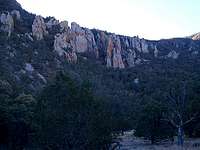
Guadalupe Mountains, Texas
Following the route of the Tejas Trail up Pine Spring Canyon.
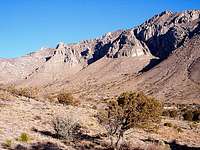
As I drove south from White Sands, I reached my first border patrol checkpoint with competing ideas about where to travel immediately next. I gave some thought to visiting Saguaro National Park west in Arizona, but at the Las Cruces junction, I decided to go ahead into Texas. A border-to-border trek across the Lone Star State was my primary idea in the beginning, and I wanted to devote my remaining week to that idea at an unhurried pace. After entering Texas northwest of El Paso, I headed for Guadalupe Mountains National Park about a hundred miles east. This drive took me through the northern Chihuahuan Desert, a very arid land of yuccas and mesquite bushes. At this time of year, the panoramas here provided little color, until I came within sight of El Capitan at the edge of the national park. It was a dramatic monolith with faint splashes of cream and pink standing tall in the electric blue sky. With that sight, I was excited to enter the Guadalupe Mountains.
Wind was a factor here at the Pine Spring Campground as well, but to a smaller degree. It still took me several minutes and a total of fourteen football-sized rocks to erect the tent and secure it to my satisfaction. By the time I was ready for a hike, I had maybe two hours of daylight available, just enough to possibly squeeze in a quick trek to the high mountains. I scurried up the Tejas Trail from the nearby trailhead at the edge of Pine Spring Canyon, keeping a close eye on the setting sun and my watch. The trail first introduced me to dry grasses and isolated trees hiding in the canyon interior. It then ascended the north side of the canyon via several rocky slopes and switchbacks. I found it instantly likable because of my combined affinities for arid landscapes and nice mountains. I advanced far enough to glimpse the Devils Hall area from above, as well as my first aerial views of the west Texas desert stretching infinitely beyond the mountains. I never tire of these wide-sweeping vistas from prominent mountains. I took in as much as I could before the fading light forced me to return. Near the end, I needed some assistance from my flashlight, but eventually I was back at my windy campsite for the night.
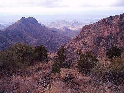
Mountains ahead of the canyon.
Rock formation along the trail.
Looking east from the canyon.
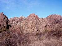
I woke up early and eager in the morning for a full, uninhibited day of hiking the Guadalupes. The air was a little chilly for the time being, so I hoped to warm myself on the sunlit El Capitan Trail. From the Pine Spring trailhead, the rock-strewn pathway danced around junipers and numerous prickly pear cacti along the east face of the range. It took me through a calm and still landscape until El Capitan prominently came into view again. The vertical rock face and its underlying hills appeared very pale from here, as if they were bleached by the sun. Skies were a brilliant blue behind them; no cloud would even think about drifting here on a day as dry as this. On its southwest route, the trail dipped into many depressions that progressively seemed to reach deeper and deeper into the earth. By the time I neared the intersection with the Salt Basin Trail, I had hiked in and out of a couple of budding canyons. A pale green souvenir rock came to me from the depths of one in particular.
Early stages of the El Capitan Trail in Guadalupe Mountains National Park.
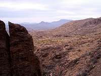
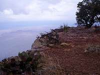
Nice views of salt flats and the Patterson Hills shined to the west here, with El Capitan standing tall immediately behind me. The trail continued a little closer to these areas before wrapping around El Capitan and Guadalupe Peak on the west. I wished to access Guadalupe Peak next, but with no certainty that I could do so on the trail ahead, I decided to go off-trail on an eastern ridge here. A mule deer appeared close to me just as I started upward; it glanced at me for a few inquisitive moments but little more. The immediate climb out of Guadalupe Canyon was quite steep and exposed. Once I maneuvered past the large boulders at the crest, I was able to relax on a steady uphill walk to the northwest. There was not much on this rocky ridge apart from clumps of dry grass and large panoramas in the distance. My only real concern ahead was an apparent rock wall of the high mountains. My ridge’s steady ascent turned steeper as it neared the sheer face, but it did not climb all the way up. I expected to find at least one tiny notch in the face somewhere, but that was something I would not know for sure until I reached it.
Many dry washes cross the trail.
The east face of El Capitan.
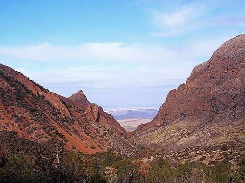
To my satisfaction, there was one such notch in the rock face, and it was accessible after a ginger walk across a slippery slope of fallen rock. I was able to slip into the cranny and climb the interior rocks to crest just above an apparent trail, the Guadalupe Peak Trail. I joined the trail expecting the peak to be only a short walk ahead, but it was actually a couple of miles away with several patches of snow lying in-between. The snow and ice was quite treacherous on exposed ledges, so it was prudent to inch my way along these areas. Due to the trail conditions and the roundabout course I improvised along the way, it was already afternoon when I reached the summit. Guadalupe Peak is the highest point both in this range and the state of Texas, so a shimmering metal pyramid adorns the top. I signed the summit register book and braced myself against the vigorous wind gusts long enough for a meal. To the north lies the continuing mountain ridges and canyons, but in all other directions the flat scrubland carries to the distant horizon. The depth of the visibility is tremendous; it so easily compresses the miles to inches.
The endless panoramas from Guadalupe Peak, clockwise from north.
I did my best to capture the panoramas in my mind and on my camera, both at the summit and on the way down. After retracing my steps while descending, I bypassed my off-trail point of intersection and followed the maintained trail back toward the campground area. There were several more areas of slippery frozen snow blanketing the trail, and they were particularly troublesome because the ice was so hardened. My best protection was to anchor my walking sticks into any existing holes, because without an ice ax, I was not going to make any new ones. Late in the day, I eased into the ice-free Pine Spring Canyon, and I ultimately hiked back to camp. The Guadalupes are a wonderful place to hike despite the prevailing winds; I thoroughly enjoyed my two days here.
Big Bend, Texas
Walls of Chisos Basin.
As I noted earlier, these Guadalupe Mountains are the most elevated in Texas. But they are not the only crown jewels here. A long desert drive southeast of the Guadalupes, in Big Bend Country, there is an intriguing confluence of mountains, desert, and a great canyon-carving river. Out of all my Lone Star destinations, I was most looking forward to this one. Around noon I reached Alpine, one of two gateways to the wonderfully remote Big Bend National Park seventy miles farther south. I hurried there and stopped at the headquarters for a backcountry permit, which I would employ on the following night. Since the drive took half the day already, I decided to go ahead to the amazingly scenic mountains ringing Chisos Basin and devote all my time here. There was a developed campground here near my backcountry trailhead, so I set up my tent.
Of course, at midday I still had plenty of opportunity for an afternoon hike, and I started one along the Window Trail. From the camp, this trail gently descends inside Oak Creek Canyon toward a particular viewpoint that shares the trail name. The rock faces are extraordinarily colored, with some reflecting rusty shades of red, light shades of rosy pink or pale purple, or dark shades of black cherry. There is plenty of rock to admire because the walls surrounding the basin stand so high. Nearest to the campground, there was prevalent dry brush and colorful cacti along the ground. This vegetation very gently receded as I trekked farther into the dry canyon, until just a few small trees dotted the banks. After an hour’s walk, I was mostly stepping on or around bare rocks, and the canyon walls were closing in tighter with each passing step.
As I rounded one of the several canyon bends, a noticeable gap appeared, referred to as the Window pour-off. Near this gap, the surface exclusively becomes a shiny slickrock. It is so slick that my boots were not foolproof; I actually needed to take them off to adhere well enough for a curious venture down to the extreme edge. In times of high water, a brilliant waterfall can cascade off this ledge, but usually it is a dry window to the wild terrain far below. Viewing such a high vista after a long descent was a neat sensation, almost a peculiar one. This really was a fabulous moment at such a unique singular spot. It can only be described as being at the mouth of a canyon in the sky.
Nearing the Window pour-off.
From the edge of the pour-off.
Back inside Oak Creek Canyon.
After returning to my gear and savoring the view a while longer with a snack, I headed back up the canyon. The return hike slowly opens to a rewarding view of its own as the shadowed canyon walls subside to the scenic Chisos Basin rock faces. I grabbed a small souvenir rock with that nice black cherry color on the way. Given its scenic nature, the trail was surprisingly solitary until I was nearly back at the campground, when I finally saw some other hikers just starting. My activity, however, was finished for the night. I finished my dinner and lied down to rest so I could gaze later at the abundant stars in the clear night sky. The stars here, as they say, are indeed big and bright.
The next day was the start of my long backcountry hike into the Chisos Mountains. I would normally harbor uninhibited eagerness, but my enthusiasm was tempered just a bit by the weather forecast posted in the developed campground. Actually, it was tempered a lot. A weather front was going to move in today, and believe it or not, bring snow with it. I definitely understand that it is January and this basin is one mile above sea level. But this basin is also as far south as Florida’s Daytona Beach. Snow is something that, in my apparent negligence, I never bothered to consider. But it was now a reality and I had to reevaluate what I was going to do on my greatly anticipated visit to Big Bend.
I was going to forge ahead. In a thorough raid of my car, I covered myself with every layer of clothing available. Tucked inside those layers and in my backpack, in place of no sleeping bag, I stuffed every blanket available. It was fairly cold already, so my only initial discomfort was the cumbersome act of moving in so many clothes, but I adapted to it. The loop to the South Rim was a fourteen mile round-trip, and I had all day to hike two-thirds of it. The skies were not foreboding at all when I started. In fact, they were quite clear and the sun was shining beautifully on the Window area I visited yesterday. I took advantage of the visibility to catch some nice views of the distinctive wild settings here. A unique combination of geological processes has hit this area over time. Rock here has been lifted by continental collision and compression, and it has been dropped by continental stretching and faulting. There has even been periodic volcanic activity here in the past, and all of it has been subject to steady erosion. As a result, the Chisos Mountains and Big Bend area in general can appear more chaotic or unpredictable than a typical mountain range. There are mountains, cliffs, mesas, pillars, and anything in-between. These spectacular variations along with the rich colors make the area so amazing.
The Window from Laguna Meadow Trail.
Chisos Mountains near Blue Creek Canyon.
From the Chisos South Rim.
On the absolute edge.
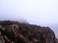
Weather hiding the next ridge.
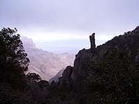
Boot Rock in Boot Canyon.
Pinnacles ringing the basin.
As I progressed, those once-clear skies of serenity started to author much of a different story. At the oak and pine groves within Laguna Meadow, I crossed paths with a large youth group. Like the other hikers I had seen today, they were briskly moving the other direction to escape the gathering storm. Before I could get to the South Rim, the horizons disappeared behind a gray haze, and stiff winds started to swirl in from all directions. The gusts absolutely roared through the trees like they were amplified. When I did reach the rim of the Chisos, I gazed at a somewhat obstructed picture far below me. Only the nearest areas of the desert floor were readily visible as a bleak and rugged jumble of points and valleys. At any significant distance, they smoothly faded into the invading gray haze. I sat down at the rim to recharge with some snacks, and as I looked on, the clouds completed their imminent takeover of the scene.
Now going northeast along the rim, I began to not only see the weather, but feel it as well. A stinging mixture of sleet and ice pelted me until I was convinced to cover my exposed hands and face. My excessive layers of clothing still kept me decently warm and served as soft armor against the elements, so this hike along the rim was not as rough as it could have been. It went quickly too, because unfortunately, there were no available distant views to stop and admire. Along the cliffs of the northeast rim, trace amounts of snow dusted much of the flora, but not the ground. This yielded the counterintuitive sight of frost-covered cactus plants. I followed the trail into the more sheltered forest inside Boot Canyon. In the canyon, I passed the Boot Rock and, after deliberation, I later bypassed the Emory Peak Trail as well to settle at my Toll Mountain campsite. Snow and a renewed wave of sleet assailed my tent while I nestled inside and started my fourteen-hour countdown to morning. All totaled, I was wearing five layers of clothing above the waist with three blankets. The temperatures would dip into the high teens over the course of the night, while an aggressive wind forcefully howled with mean intent. The sleep I managed to acquire was in short segments interrupted by shivers. My night, like the day, was full of hardship, but it was foreseeable adversity that I faced willingly. I did not mind the weather; I knew I could overcome it. I did not mind the risk of such isolation; I rather enjoyed the solitude. I just wanted to be out here.
Once daylight arrived, I decided to quickly pack up and finish the return hike. Of course, the moment as I rolled out of my cocoon of warm blankets, I had second thoughts. Soon enough, after a quick breakfast, I dusted off the snow clinging to the tent and folded up everything. There were brilliant bright red rocks all over the ground, so I took one as a souvenir. My hike between Toll Mountain and the trailhead was virtually all downhill via the Pinnacles Trail. This trail is so named because of several striking rock pinnacles that sprout from the pinyon and juniper forest. It was neat to walk among them and also see them from a distance later in the adjacent meadows. Out of those meadows, I met another person for the first time in about a day. Two volunteers were working on a trail sign, and they were amazed to hear that anyone had camped in the Chisos the previous night. The woman volunteer asked me about the wind and sleet and snow, and when I validated all of that, she hesitated a bit in surprise before complimenting me as a hearty camper. At least, I think she meant it in good nature. She may have also been wondering why in the world I would do such a thing, but if anyone asks, they probably would not understand.
Desert fronting the Rosillos Mountains.
A dry wash and the Rosillos Mountains.
A short distance ahead in the parking lot, I slumped in the seat for a while to figuratively catch my breath after that tough overnight hike. The climate-controlled interior was not a bad deal either. On my way through the northern park, I paused at a few random places to check out the mesquite shrubs and creosote bushes against the Rosillos Mountain backdrops. Then I headed to my next visit with the border patrol. This agent merely took the time to glance at me before sending me ahead. Perhaps he saw my appealing mixture of dirty clothes, untidy hair, and discarded food wrappers, and decided he wanted no part of that. Anyway, I continued ahead and hooked up with the eastbound highway.
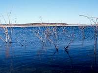
Amistad & Padre Island, Texas
Amistad Reservoir.
Padre Island dunes.
Sam Houston National Forest.
After five days within, I finally started to ease out of the Chihuahuan Desert along the arid scrublands paralleling the Rio Grande River. There were more than a few border patrol vehicles stationed along the way. I should have kept a running count now that I think of it. But then, I was just thinking of a warm place to stay for the night. A few campgrounds lied in the Amistad National Recreation Area, situated around the giant reservoir that straddles the international border. I found one that charged a hefty four dollars per night, but I took it anyway. One of the manmade lake’s northern arms stretched beside the campground. I walked along the dirty banks of the shore for a little while to get a souvenir rock, but there were no real hiking trails. An extended night of rest felt preferable anyway, and fortunately tonight, the temperatures were pretty mild.
Since there was not much to do at the Amistad Reservoir, unless I traded my car for a boat, I continued southeast in the morning along the Rio Grande. As I was nearing Laredo, I turned straight east and dove into the Texas brush country. There are really no tall trees here, but this ecoregion still catches your eye with its staggering density. If I had any assumptions about how much mesquite and underbrush could be compacted within a given space, this area exceeded those assumptions for many miles. After yet another border patrol checkpoint, where drug-sniffing canines saw no interest in my stale food and laundry contents, I effortlessly went east on the smooth roads that slice through the brush. The density gradually tapered until the countryside was a monopoly of farmland. East of Corpus Christi, I crossed the northern edge of Laguna Madre to one of the largest barrier islands in the world, Padre Island.
I stopped at the Malaquite Visitor Center for camping information, and a polite worker tried to help, but it may have been his first day on the job. He thought the only camping areas lied to the north by Mustang Island, but I already had some information from online research that implied otherwise. I ignored his suggestions and went south to the wilderness beach. This beach indeed offered free camping on the ocean shores, and I took advantage of it. Driving my car on the beach was sort of worrisome for me, but the sand seemed to be very hard-packed for at least the first mile, and I parked above the high tide watermarks at that mile. Until sunset, I was content to walk the beach, grab a shell or two, and check out the tall interior dunes. The weather was nice for sleeping, as calm as the tempered waves lapping the shoreline.
The ocean waves are always a wonderful background ambience for me, especially when first waking up in the morning. I caught the sunrise over the Gulf of Mexico on a short stroll to stretch myself out. Then I shook off the beach sand, packed up, and drove back up the beach to the national seashore road. I continued in that northerly direction, parallel to the Texas gulf coast, for most of the morning. There was a lot of flat agricultural land in this part of the state, and it was often covered in rich dark soil. At first glance, it surprised me how similar the area was to the farmland of the midwest.
After the large swath of farmland, I steered through the equally large metropolitan area of Houston, and then I visited the Sam Houston National Forest an hour’s drive north of the city. The Big Creek Scenic Area seemed like a good place to hike a section of the 130-mile Lone Star Hiking Trail. This land was a pretty typical representation of eastern Texas piney woods. Pine and hickory trees were pretty dense, terrain was very flat, and most uniquely, there were no rocks to speak of. Whether it was in the underbrush or the creek bottoms, I failed to see even the smallest pebble. After a short loop through the woods, I decided to hurry out for a potential hike in Louisiana’s Kisatchie National Forest. It was an ambitious plan late in the day, but the Kisatchie Hills Wilderness was just too far to the east and darkness came too soon. My views on the Longleaf Trail Scenic Byway were restricted to the range of my automobile headlights. The roads of northern Louisiana were fun while I was there, offering endless hills and sharp bends to enjoy, but the drive home turned routine after that. I followed the Mississippi River north with one nighttime period of rest. After awaking under frosted windows the next morning, I concluded the final segment home.
Parents refers to a larger category under which an object falls. For example, theAconcagua mountain page has the 'Aconcagua Group' and the 'Seven Summits' asparents and is a parent itself to many routes, photos, and Trip Reports.


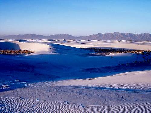 All seems calm enough in White Sands.
 Clouds ominously rolled in before sunset.
 A deceptively large depression between the dunes.
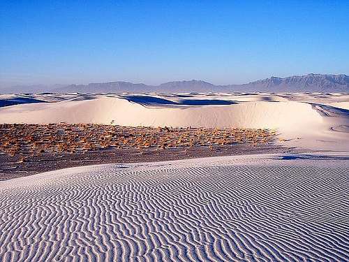 White Sands on a sunlit winter morning.
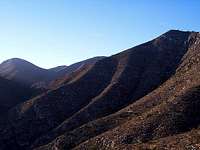 Mountains ahead of the canyon.
 Rock formation along the trail.
 Looking east from the canyon.