
|
|
Mountain/Rock |
|---|---|
|
|
44.89420°N / 118.2316°W |
|
|
8600 ft / 2621 m |
|
|
Overview
Ruth Mountain is one of the more remote and lesser known peaks of the Elkhorn Mountains of northeast Oregon. From the Baker Valley below it can only be seen from a few select places and reaching it requires combinations of long hikes or driving on difficult, rugged roads. It forms a crested pyramid on the main dividing ridge of the range with relatively gentle ridges separated by steep faces with west, northeast and southeast aspects. It rises 2,600 feet above the headwaters of the North Fork Powder River to the east and 2,700 feet above the North Fork John Day headwaters to the west. Primitive roads can get one into each of these basins. Other routes to the mountain require long hikes. | 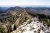 |  |  |  |
Getting There
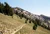
Whether coming from the north or south on Interstate 84, take exit 285 at North Powder and head west on North Powder River Lane (county road 101) for 4.0 miles. Turn left on Ellis Road and continue for 0.6 mile to the junction with the Anthony Lakes Highway. Turn right on the Anthony Lakes Highway and continue for 15.7 miles to the left turnoff to Anthony Lake Campground. Continue for about 100 yards then take a right, following the signs to the day use parking, which is on the southwest corner of the lake.From the parking lot, head east along the south side of the lake on the Anthony Shoreline Trail, 1605. About where the trail meets a road on the east side of the lake a trail continues on east to Lilypad Lake and becomes the Elkhorn Crest Trail, 1611. Continue on this trail for almost a mile to where the trail splits. A sign will indicate the trail to the right goes to Black Lake. Go left (straight) and follow the trail above the east side of Black Lake and into the upper Antone Creek basin. Continue on through Angel Pass to Dutch Flat Saddle, which is about 3.5 miles from Anthony Lake. Continue south on the main trail for another 0.75 mile to Cunningham Saddle. Continue on the main trail south for another slightly over one mile to Nip and Tuck Pass, then another mile on to Lost Lake Saddle, which is a broad low spot on the crest that will rise to the north ridge of Ruth Mountain, 0.75 mile to the south. This summit is approximately 7.5 miles from Anthony Lake.
The north ridge and many of the faces can be scrambled, but some routes are better than others. There are some cliffs and very steep rocks to be negotiated on the northeast face, while the west side is less steep, but the rocky slopes are very difficult walking. The south ridge appears to be a good scramble option as well. Other routes remain to be investigated.
Ruth Mountain can also be accessed from the west via the 7300-380 road to Peavy Cabin, in the North Fork John Day basin or from the east by the 7301 road up the North Fork Powder River (see camping section). Both these routes are shorter and more direct, but require steeper hikes and don’t give the scenic tour of the northern Elkhorns offered by the Crest Trail.
 |  |
Red Tape
There is no red tape other than standard wilderness regulations for people hiking from day use parking lot at Anthony Lake. But this is a long day hike covering approximately 15 miles round trip. Persons backpacking in for extended stays should use the Elkhorn Crest trail parking lot, which turns left off the highway just before the Anthony Lake Campground turn. Use of this trailhead requires a Northwest Forest Pass, which cost $5 ($30/year) and can be purchased all all local Forest Service offices and at many area businesses.No pass is required to enter the area via Peavy Cabin or the North Fork Powder River.
When To Climb
Most people climb the mountain from late July to October. The mountain would be very hard to access during the winter.Camping
Anthony Lake Campground is where the hike begins. This campground can be very crowded and noisy at times. Smaller campgrounds very close to Anthony Lake are found at Grande Ronde Lake and Mud Lake. Black Lake is much quieter and there is at large camping allowed basically anywhere. However, good back country camping along the Elkhorn Crest is limited due to topography. Lost Lake and the adjacent low basin northeast of Ruth Mountain might be the best camping option. The Lost Lake Trail, 1621 departs from the crest trail about half way between Nip and Tuck Pass and Lost Lake Saddle. Beyond Lost Lake, the trail connects with the North Powder Trail, 1632. Trail 1632 passes by Meadow Lake, which is another camping option at the foot of the mountain’s east ridge. The 7301 road up the North Fork Powder River provides access to these lakes and Ruth Mountain via the east end of Trail 1632.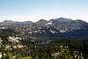 |
Mountain Conditions
Current mountain conditions can be obtained from the US Forest Service:Baker Ranger District
3165 10th Street
Baker City, Oregon 97814
(541) 523-4476
NOAA Forcast