Introduction
It is rare that I can get time off in summer so when I had a chance to take a week off, Kessler (my seven year old son) and I decided to head off to the Beartooth Mountains for some backpacking, fishing and mountain climbing. Our plan was ambitious. With heavy packs loaded with a week’s worth of supplies we would climb as many peaks as possible (all rated class 2-4 in difficulty) in the time period of seven days. We would also do many side trips to the different drainages and visit several of the other isolated and trail-less cirques and lakes.
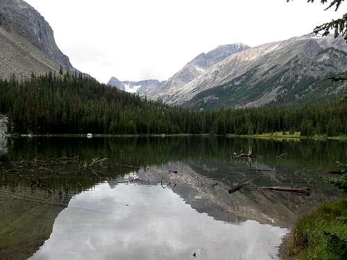
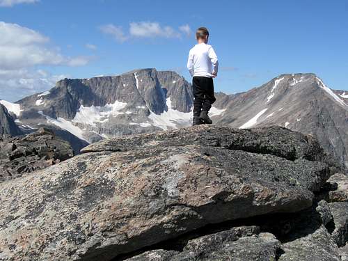
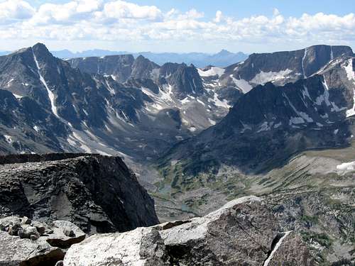
![Final Approach]() Resting before the final climb of Whitetail Peak which is upper left on August 25 2009.
Resting before the final climb of Whitetail Peak which is upper left on August 25 2009.August 23
We arranged to have a taxi driver meet us at the West Fork Rock Creek Trailhead and drive us around to the Lake Fork Trailhead. The cost was $80, but it was worth it in order to do a long loop hike.
We left the Lake Fork Trailhead under cloudy skies and hope that the weather would improve. It was a long and hard five miles to the Lost Lake turnoff. Normally, five miles in nothing, especially on a trail, but today it was challenging because of our huge packs. I had brought an over abundance of gear prepared for possible winter conditions (the Beartooth Mountains are well known for possible bad weather) as well as eight days worth of food and supplies. With all this equipment my pack weighed 72 lbs (33 kgs) and Kessler’s weight 10 lbs (5 kgs) so it was slow going.
As soon as we reached the turnoff to Lost Lake we all too happily dumped our packs and set off to explore the spectacular Black Canyon drainage. We had hoped to reach Black Canyon Lake over a rugged off-trail route, but it began to rain just short of the lake and in the boulderfield the rocks were very slippery. We turned back and hiked back down the steep route in the rain. By the time we reached our camp it was raining very heavily.
![Black Canyon]() This is Black Canyon near Black Canyon lake not long before it started raining. Because of the slick boulderhopping when the rocks were soaked, we didn't quite make it to the lake.
This is Black Canyon near Black Canyon lake not long before it started raining. Because of the slick boulderhopping when the rocks were soaked, we didn't quite make it to the lake.
When the rain tapered off a bit after dinner, we hiked to Lost Lake in the light rain and tried fishing, but didn’t have luck. It began to rain harder again and we headed back to camp (8400 feet/2560 m). Since it was raining hard we spent the rest of the evening in the tent. After dinner Kessler went to bed early and I read
High Adventure by Sir Edmund Hillary and enjoyed it very much.
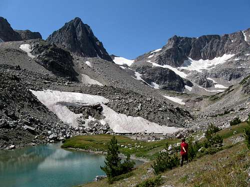
![Near Black Canyon Lake]() Nearing Black Canyon lake in the light rain on August 23 2009. The steep slopes of Rearguard Mountain tower above.
Nearing Black Canyon lake in the light rain on August 23 2009. The steep slopes of Rearguard Mountain tower above.August 24
It rained hard all night, but my morning it was down to a light drizzle at a temperature of 40F (4C). We hiked up the trail to Keyser Brown Lake(where we dropped the packs) in mostly good weather with only some very light sprinkles. We set off towards the spectacular Rock Lakes.
![Lake Fork]() This is Kessler at the crossing of the Lake Fork Creek on August 24 2009.
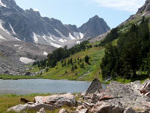
This is Kessler at the crossing of the Lake Fork Creek on August 24 2009.![Keyser Brown Lake and Sky Pilot Peak]() Sky Pilot Peak forms a nice background to Keyser Brown Lake.
Sky Pilot Peak forms a nice background to Keyser Brown Lake.
Lower Rock Lake was a relatively easy, but somewhat wet off trail hike, but reaching the Upper Rock Lake proved to be a greater challenge. Our route took us through some rough boulderhopping, wet marshy ground and some thick bushwhacking, but the scenery was spectacular, especially the views of Beartooth Mountain.
![Sky Pilot Peak]() Sky Pilot Peak rises above Lower Rock Lake.
Sky Pilot Peak rises above Lower Rock Lake.![Boulderhopping]() Getting to Upper Rock Lake required lots of boulderhopping.
Getting to Upper Rock Lake required lots of boulderhopping.
On the way down we found an easier route with signs of use that stayed much closer to the stream than the route we took up. We returned to Keyser Brown Lake and started up the hill to timberline at September Morn Lake. Because our packs were still heavy it was pretty slow going, but we set up a nice campsite at 9750 feet (2972 m) and overlooking the lake. The day had pretty good weather and was a mix of clouds, sun and light sprinkles.
![Beartooth Mountain]() The north side of Beartooth Mountain as seen from near Rock Creek Lakes on August 24 2009.
The north side of Beartooth Mountain as seen from near Rock Creek Lakes on August 24 2009.![September Morn Lake]() September Mourn Lake and Thunder Mountain as seen on August 24 2009.
September Mourn Lake and Thunder Mountain as seen on August 24 2009.![Beartooth Mountain]() Beartooth Mountain as seen from our campsite at September Morn Lake.
Beartooth Mountain as seen from our campsite at September Morn Lake.August 25
Today would be one of the most challenging days planned for the entire trip. We woke up with a frosty 29F (-2C) with perfect bluebird weather. We were good to go on our climb of Whitetail Peak! Luckily we wouldn’t have to carry our heavy packs today. Without heavy packs we made good time up to Sundance Pass at 11,037 feet (3364 m). We climbed south up Mount Lockhart, scrambling to the summit before starting up Whitetail Peak (at 12,548 feet/3825 meters, it is the 4th highest peak in Montana).
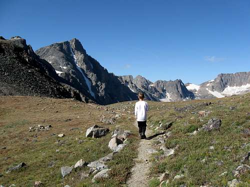
![Approaching Sundance Pass]() Kessler approaches Sundance Pass on August 25 2009. Whitetail Peak rises in the background.
Kessler approaches Sundance Pass on August 25 2009. Whitetail Peak rises in the background.![Switchbacks]() Looking down the to Sundance Pass and the many switchbacks coming up from West Fork Rock Creek.
Looking down the to Sundance Pass and the many switchbacks coming up from West Fork Rock Creek.![Sundance Pass]() Kessler enjoys the views of Castle and Sundance Mountains from Sundance Pass.
Kessler enjoys the views of Castle and Sundance Mountains from Sundance Pass.![Summit pitch of Mount Lockhart]() This is the summit pitch of Mount Lockhart as viewed on August 25 2009.
This is the summit pitch of Mount Lockhart as viewed on August 25 2009.![Mount Lockhart]() Kessler on the summit of Mount Lockhart.
Kessler on the summit of Mount Lockhart.
We climbed the ridge up Whitetail Peak, finding it really spectacular and with awesome views. We met a group half way up and they were very impressed to see Kessler up there. They warned us about the exposed section of climbing near the summit. We talked with them a few minutes before heading back up the impressive ridge.
![Glacier]() A glacier on Beartooth Mountain as seen from near the summit of Whitetail Peak.
A glacier on Beartooth Mountain as seen from near the summit of Whitetail Peak.![Beartooth Mountain]() Kessler takes aa break while climbing Whitetail Peak on August 25 2009. Beartooth Mountain and the Beartooth itself rises in the background.
Kessler takes aa break while climbing Whitetail Peak on August 25 2009. Beartooth Mountain and the Beartooth itself rises in the background.
Once we reached the top of the relatively famous Whitetail Couloir and tackled the crux of the route (the one we were warned about above). Some sources rate this pitch as Class 4, but we thought it felt more like a solid Class 3 and the exposure wasn’t that bad. We quickly made the summit for a well deserved, but relatively late lunch break. The views were absolutely spectacular and we kicked back to soak in the sight of all the peaks, glaciers and lakes (one of which was still almost completely frozen). There was only a light breeze and the weather was great so it was a very pleasant experience.
![Nearing the summit]() Kessler starts the Class 3 section on the climb of Whitetail Peak.
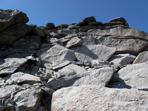
Kessler starts the Class 3 section on the climb of Whitetail Peak.![Crux]() Kessler climbs the crux pitch on Whitetail Peak. Some rate this pitch class 4 in difficulty, but it seemed more like a solid class 3 to us.
Kessler climbs the crux pitch on Whitetail Peak. Some rate this pitch class 4 in difficulty, but it seemed more like a solid class 3 to us.
After enjoying the summit we headed back down to our camp at September Morn Lake after a wonderful day.
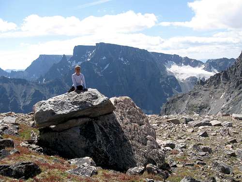
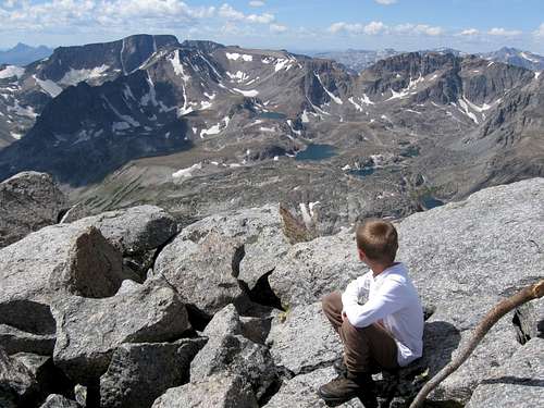
![Granite Peak]() Kessler points out Granite Peak, the highest peak in Montana as seen from the summit of Whitetail Peak (Montana's 4th highest).
Kessler points out Granite Peak, the highest peak in Montana as seen from the summit of Whitetail Peak (Montana's 4th highest).![Summit of Whitetail Peak]() Seven year old Kessler on the summit of Whitetail Peak, the 4th highest mountain in Montana. August 25 2009. Sky Pilot Mountain is in the background.
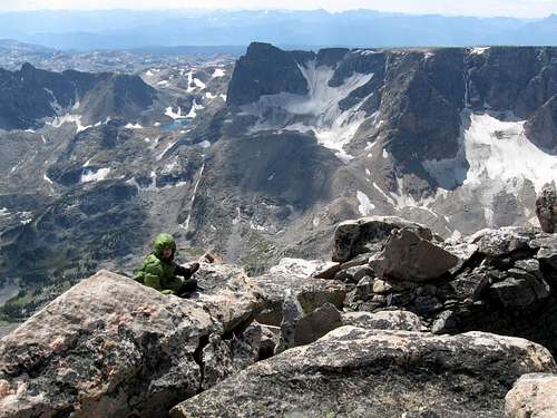
Seven year old Kessler on the summit of Whitetail Peak, the 4th highest mountain in Montana. August 25 2009. Sky Pilot Mountain is in the background.![Chilly]() When we reached the summit of Whitetail Peak on August 25 2009, it was a bit chilly on top, but the weather was great. Sky Pilot Mountain is in the background.
When we reached the summit of Whitetail Peak on August 25 2009, it was a bit chilly on top, but the weather was great. Sky Pilot Mountain is in the background.August 26
It was cloudy and sprinkled the night before, but by morning the weather looked pretty good. Because of the clouds it was a warmer 35F (2C). We headed back up towards Sundance Pass, but it was more challenging than the day before because we were carrying our big packs. We dropped our packs at the pass and headed up south towards Silver Run Peak (at 12,542 feet/3823 meters, it is the 5th highest mountain in Montana). The weather was good and we made our way across the boulderfields to the summit.
The summit of Silver Run Peak is a spectacular place to be because although the east slopes are gentle, the west face drops down to the West Fork Lake Fork below in a steep cliff nearly 3500 feet (1066 meters) high. Although it really isn’t completely vertical, it sure looks like it from the top and the summit is an exciting place to be.
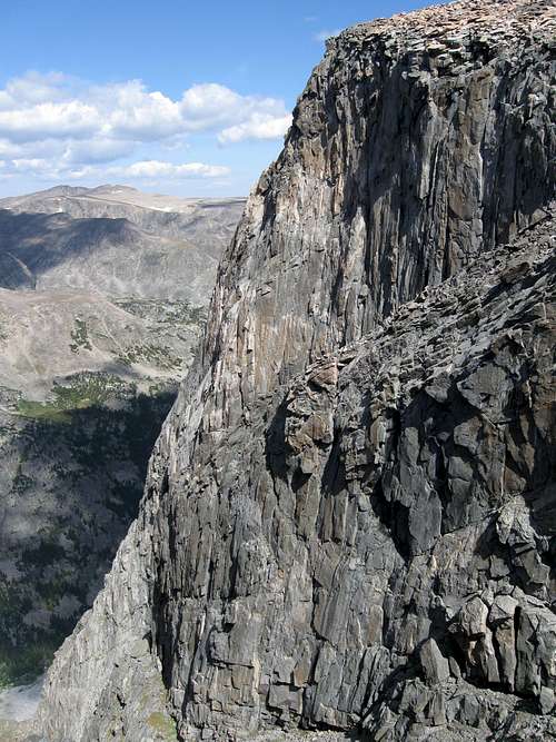
![Huge West Face]() This is the huge West Face of Silver Run Peak which drops 3500 feet down to the valley below. Luckily the east face is relitively easy to climb.
This is the huge West Face of Silver Run Peak which drops 3500 feet down to the valley below. Luckily the east face is relitively easy to climb.![View from the summit]() View from the summit of Whitetail Peak on August 26 2009. Left to right: Whitetail Peak, Sky Pilot Peak and Castle Mountain. Pilot Peak can be seen in the far background.
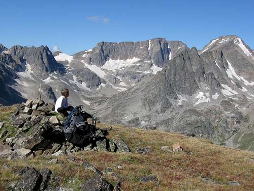
View from the summit of Whitetail Peak on August 26 2009. Left to right: Whitetail Peak, Sky Pilot Peak and Castle Mountain. Pilot Peak can be seen in the far background.![Summit of Silver Run Peak]() Seven year old Kessler on the summit of Silver Run Peak on August 26 2009. Silver Run Peak is the 5th highest peak in Montana. In the near background, left to right, Castle, Sundance and Bowback Mountains can be seen. In the far background left you can make out Pilot Peak and in the far background right is Granite Peak (highest mountain in Montana).
Seven year old Kessler on the summit of Silver Run Peak on August 26 2009. Silver Run Peak is the 5th highest peak in Montana. In the near background, left to right, Castle, Sundance and Bowback Mountains can be seen. In the far background left you can make out Pilot Peak and in the far background right is Granite Peak (highest mountain in Montana).
After enjoying the wonderful views from the summit and having a nice lunch we headed back to Sundance Pass where we left our packs. There were two mountain goats at the pass and we spent a few minutes watching them before reluctantly shouldering our big packs and heading down the 30 switchbacks down to the West Fork of Rock Creek.
It was getting late and there were two people (a teenage girl and her father) camped near the stream crossing (9550 feet/2911 m), but they said they didn’t mind company and we shared a campsite. We talked with them and shared our dessert with them before going to bed.
![Mountain Goats]() Mountain Goats hang out at Sundance Pass on August 26 2009. Little did we know that they would keep us up that night!
Mountain Goats hang out at Sundance Pass on August 26 2009. Little did we know that they would keep us up that night!![Camp]() Our camp near Sundance Crossing on August 26-27 2009. Sundance Mountain is in the background.
Our camp near Sundance Crossing on August 26-27 2009. Sundance Mountain is in the background.August 27
It wasn’t a restful night. Two mountain goats kept sniffing and digging around the tent and made quite a ruckus. I would shine my light at them and they would run up in the rocks only to return a short time later. I wondered if they were making a game of it and they seemed intent on keeping us awake as long as they could. We awoke to another morning of 35F/2C and we set off to explore the impressive and trail-less valley and cirque at the head of the West Fork Rock Creek. We passed Shadow Lake and headed up to the Silt Lakes. Along the way we climbed through a boulderfield full of spiders that would shake at you (presumably to scare you away) when you passed. We then explored along the creek and moraines to the cirque containing the Silt Lakes. The lakes were beautiful and to get to the upper one we had to walk on the ice a bit, but we enjoyed a nice view above the lake before returning back to our camp and packs.
![Sundance Crossing]() Our camp near Sundance Crossing on August 26-27 2009. Sundance Mountain is in the background.
Our camp near Sundance Crossing on August 26-27 2009. Sundance Mountain is in the background.![Castle Mountain]() We explored the cirque around Silt Lakes and below Castle Mountain.
We explored the cirque around Silt Lakes and below Castle Mountain.![Medicine Mountain]() Medicine Mountain towers over the Silt Lakes on August 27 2009.
Medicine Mountain towers over the Silt Lakes on August 27 2009.![Silt Lakes and Medicine Mountain]() On August 27 2009, we explored around the Silt Lakes and found a fine view of Medicine Mountain.
On August 27 2009, we explored around the Silt Lakes and found a fine view of Medicine Mountain.
We shouldered our packs (now much lighter than in days past) and headed down to the Lake Mary Junction near Quinnebaugh Meadows where we set up camp at 8850 feet (2698 m). It was a beautiful evening with an awesome sunset and a nice half moon.
![Silver Run Peak]() From West Fork Rock Creek on August 27 2009, we had a fine view of Silver Run Peak which we climbed on August 26.
From West Fork Rock Creek on August 27 2009, we had a fine view of Silver Run Peak which we climbed on August 26.![Sunset]() This is the sunset as viewed from our camp along the West Fork of Rock Creek.
This is the sunset as viewed from our camp along the West Fork of Rock Creek.August 28
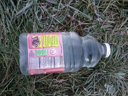
The last night was the most incredibly cold summer night I had ever spent. The temperature dropped to an almost unbelievable 10F (-12C) and all of our water bottles froze solid. Since our elevation was lower than previous nights, I presume that the cold air sinks off the mountains and pools into this meadow. In fact, this night at least tied the coldest temperature at a camp I have ever recorded anytime between April 17 and October 25. I stayed warm throughout the night, but Kessler got cold and we put his parka on in the middle of the night. A porcupine and skunk (?) kept me up much of the night.
![Frozen Solid!]() The night of August 27-28 was the most incredibly cold summer night I had ever spent. The temperature dropped to an almost unbelievable 10F (-12C) and all of our water bottles froze solid.
The night of August 27-28 was the most incredibly cold summer night I had ever spent. The temperature dropped to an almost unbelievable 10F (-12C) and all of our water bottles froze solid.
In the morning Kessler and I set off to climb Grass Mountain (11,052 feet/3369 feet) in perfect weather. We hiked the trail up to Lake Mary where we had a cold bath and then left the trail to climb the slopes to the north. We surprisingly found and old constructed trail (probably part of an old route to East Rosebud) and followed it a ways before it faded away. We climbed up the slopes of Grass Mountain and followed the stable and relatively easy boulderfields to the summit. The summit of Grass Mountain was made of interesting blocks of granite and was a fun little climb. We ate lunch and enjoyed the fine views before returning back to Lake Mary and then back to camp.
![Climbing Grass Mountain]() Climbing Grass Mountain on August 28 2009. Whitetail Peak can be seen in the left background while Elk Mountain is far right with Lake Mary below.
Climbing Grass Mountain on August 28 2009. Whitetail Peak can be seen in the left background while Elk Mountain is far right with Lake Mary below.![Climbing Grass Mountain]() Kessler on a gentle section of Grass Mountain on August 28 2009.
Kessler on a gentle section of Grass Mountain on August 28 2009.![Summit]() Kessler climbs the last rock formation to reach the summit of Grass Mountain on August 28 2009.
Kessler climbs the last rock formation to reach the summit of Grass Mountain on August 28 2009.August 29
We awoke up to a frosty, but warmer than the previous night 28F (-2C) morning. It was sadly our last day and we had to get up early in order to visit the Dinosaur Center in Thermopolis (WY) and to make the entire drive home.
Still in perfect weather we headed down the trail down past some nice waterfalls and rock walls and towers before walking through a long burned out area from a forest fire last year. We made fairly quick time to the trailhead since we were in shape by now and our packs were lighter.
![Final camp]() August 28-29 2009 was our final camp in the Beartooth Mountains after a seven day backpacking/mountaineering trip. Silver Run Peak rises in the background.
August 28-29 2009 was our final camp in the Beartooth Mountains after a seven day backpacking/mountaineering trip. Silver Run Peak rises in the background.![Grass Mountain]() These are some of the crags of Grass Mountain as seen on August 29 2009 from West Fork Rock Creek.
These are some of the crags of Grass Mountain as seen on August 29 2009 from West Fork Rock Creek.Epilogue
Other than the first evening of the trip, the weather was as close to perfect as can be expected. We were very successful and reached the summit of some nice and spectacular peaks and did some great exploring.
![Golden Mantled Squirrel]() This golden mantled squirrel greeted us at Sundance Pass after our succesful climb of Whitetail Peak on August 25 2009.
This golden mantled squirrel greeted us at Sundance Pass after our succesful climb of Whitetail Peak on August 25 2009.


Comments
Post a Comment