|
|
Mountain/Rock |
|---|---|
|
|
32.76766°N / 107.60593°W |
|
|
Sierra |
|
|
6697 ft / 2041 m |
|
|
Overview
Berrenda Mountain North is located 4.1 miles northwest of the ghost town of Lake Valley in southwestern New Mexico. There are numerous working ranches in the area, but the majority of the land lies within state-owned conservation easements. There are some private residences, most of which are on 40 and 60 acre tracts of land.
This area of New Mexico is physiographically known as the Mogollon-Datil volcanic field, part of a discontinuous belt of middle Cenozoic volcanism that stretches from the San Juan volcanic field in southwestern Colorado, through the Trans-Pecos volcanic field in west Texas, and southward to the Sierra Madre Oriental in central Mexico.
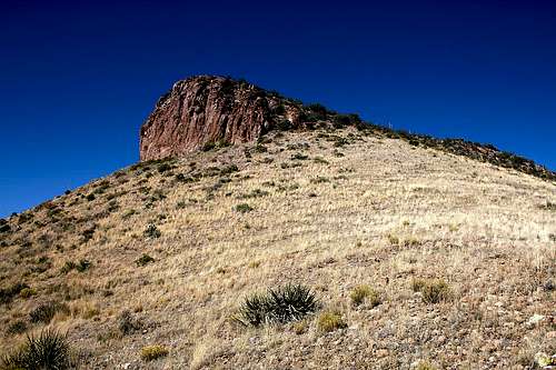
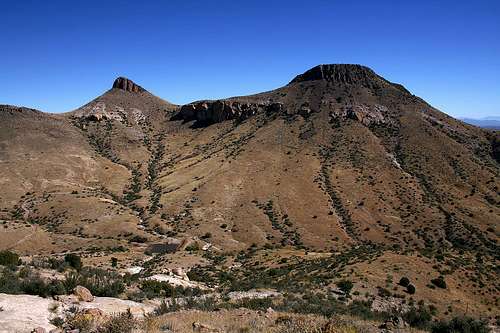
Berrenda North has an elevation of 6,697 feet and a prominence of 317 feet. Of the ten named summits within a 6.5 mile radius of the Lake Valley townsite, it ranks second in elevation only to big sister Berrenda South (6,703 feet). Like other desert peaks in this area, the typical sharp and spiny desert plant life is present, although not in overabundance. This makes for more fun and less pain in reaching the summit.
Lake Valley
Lake Valley was a thriving silver mining town in the 1880s and with a population that peaked at 4,000, was one of the largest towns in New Mexico Territory. It is perhaps best known as the site of the richest lode of silver ever discovered, aptly nicknamed “The Bridal Chamber”. The silver in this mine was so pure that it did not require refinement, and a railroad spur leading to the mine shaft was constructed so that silver could be loaded directly onto the ore cars. After the devaluation of silver in 1893, Lake Valley, like other silver mining towns, saw a decline in production and population. The town eventually died and is today a BLM-managed historic site.Getting There
From the southeast: From Interstate 25, take NM Hwy 26 approximately 20 miles, proceeding west through the town of Hatch; turn right onto NM Hwy 27 at Nutt Station (do not blink or you will miss your turn!) and proceed north for about 13.6 miles. You will pass the Lake Valley townsite to your right and Town Mountain to your left; turn left onto the gravel road (County Road B-005) just past Town Mountain. See Detailed Directions below for further info.From the southwest: From Interstate 10 in Deming, take US Hwy 180 West and proceed north for 1.2 miles; proceed east on NM Hwy 26 for about 28 miles; turn left onto NM Hwy 27 at Nutt Station and proceed north for about 13.6 miles. You will pass the Lake Valley townsite to your right and Town Mountain to your left; turn left onto the gravel road (County Road B-005) just past Town Mountain. See Detailed Directions below for further info.
From the west or north: From NM Hwy 152, turn south onto NM Hwy 27 in Hillsboro and proceed about 17.4 miles; turn right onto the gravel road County Road B-005) just before you reach Town Mountain. See Detailed Directions below for further info.
Detailed Directions: After making the turn onto the gravel road on the northeast side of Town Mountain, proceed northwest for about 2.1 miles. Two options from here:
1. Turn left onto County Road B-004 and proceed west for about 0.7 miles; turn right onto the 4WD road and proceed north for about 1.8 miles; turn right (not mapped) and proceed east for about 0.7 miles. You will pass O Bar O Peak (distinguished by a large boulder at its summit) to your right as you approach Berrenda South and North summits. There is a gravel clearing where you can park between the northeast slope of O Bar O Peak and the west slope of Berrenda South. You should be able to cover most of this route, including some on the 4WD road, in a 2WD vehicle.
2. Turn right onto County Road B-004 and proceed east for about 1.7 miles; turn left onto the 4WD road and proceed north for about 1 mile, ending up on the east side of the ridge adjoining Berrenda South and North. I did not take this route and list it here strictly for reference; info attained from USGS topographic map.
NOTE: After making the turn onto the gravel road off Hwy 27, as you proceed to your destination, please be aware that there are some private roads leading to residences. Please observe and respect the signs that are posted. Additionally, as of October 2007, there is some development underway in the area after turning onto the 4WD road, with what I believe to be a limited number of low-density residential lots being laid out. This means that the access information I’ve provided could change in the short-term future.
Route to Berrenda North summit
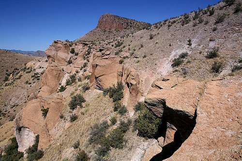
The best route to summit Berrenda North, whether approaching from the west or east side of the mountain, is to gain the adjoining ridge (elev. ~6,400 ft.) then cut up the south slope towards the summit. There is an abundance of loose rock and talus and the slope grade varies between 30 and 40 degrees. I saw no trails whatsoever, but the route-finding is pretty straightforward. Cacti, although present, is sparse enough to not be an issue.Depending on your approach, you can expect 800-950 feet elevation gain over about 0.7 to 1.1 miles.