
|
|
Mountain/Rock |
|---|---|
|
|
32.72001°N / 107.58804°W |
|
|
Sierra |
|
|
6424 ft / 1958 m |
|
|
Overview
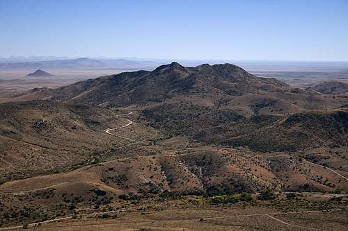
Town Mountain is a desert peak that overlooks the ghost town of Lake Valley is southwestern New Mexico. This area of New Mexico is physiographically known as the Mogollon-Datil volcanic field, part of a discontinuous belt of middle Cenozoic volcanism that stretches from the San Juan volcanic field in southwestern Colorado, through the Trans-Pecos volcanic field in west Texas, and southward to the Sierra Madre Oriental in central Mexico.

Town Mountain has an elevation of 6,424 feet and a prominence of 654 feet. Its location relative to the Lake Valley townsite probably has a lot to do with the origin of its name. It is the highest of several peaks in the immediate vicinity of Lake Valley and offers commanding 360 degree views from the summit. This peak features the sharp and spiny plant life typical of desert peaks, although not too bad compared to others I’ve seen.

Lake Valley
Lake Valley was a thriving silver mining town in the 1880s and with a population that peaked at 4,000, was one of the largest towns in New Mexico Territory. It is perhaps best known as the site of the richest lode of silver ever discovered, aptly nicknamed “The Bridal Chamber”. The silver in this mine was so pure that it did not require refinement, and a railroad spur leading to the mine shaft was constructed to allow the silver to be loaded directly onto the ore cars. After the devaluation of silver in 1893, Lake Valley, like other silver mining towns, saw a decline in production and population. The town eventually died and is today a BLM-managed historic site.
Getting There
From the southeast: From Interstate 25, take NM Hwy 26 approximately 20 miles, proceeding west through the town of Hatch; turn right onto NM Hwy 27 at Nutt Station (do not blink or you will miss your turn!) and proceed north for 13 miles. You will see the Lake Valley townsite to your right and Town Mountain to your left. Find a turnout alongside Hwy 27 and park.From the southwest: From Interstate 10 in Deming, take US Hwy 180 West and proceed north for 1.2 miles; proceed east on NM Hwy 26 for about 28 miles; turn left onto NM Hwy 27 at Nutt Station and proceed north for 13 miles. You will see the Lake Valley townsite to your right and Town Mountain to your left. Find a turnout alongside Hwy 27 and park.
From the west or north: From NM Hwy 152, turn south onto NM Hwy 27 in Hillsboro and proceed about 18 miles. The Lake Valley townsite will be to your left and Town Mountain will be to your right.
Route to Town Mountain summit
The easiest route is up the east slope of the mountain, then approaching the summit from the south. It is about 1.0 miles to the summit with 910 feet elevation gain.This is a fun summit. For most of the route, there is no trail. Route-find your way up the east slope. As you near the top, you might think you're almost done, until you see the real summit. It was in this area that I came across a very faint trail that leads to the west then turns north towards the summit. There are an abundance of large rocks and boulders in the very last stretch to gain the summit. The best route seemed to be to the left of these rocks. However, I encountered a rattlesnake going that way (Oct. 2007) and had to go over the rocks on the right side. Be careful - many of these rocks, including some of the larger ones, are loose.

GPS Coordinates
The following coordinates may be helpful if you use GPS. The elevations below were taken from my GPS altimeter.| Waypoint | Elevation | Latitude | Longitude |
|---|---|---|---|
| Good parking spot | 5,449’ | 32.71687 N | 107.57517 W |
| Starting point | 5,517' | 32.71858 N | 107.57692 W |
| Faint trail | 6,302’ | 32.71920 N | 107.58759 W |
| Town Mountain summit | 6,427’ | 32.72001 N | 107.58804 W |