
|
|
Mountain/Rock |
|---|---|
|
|
32.75192°N / 107.65135°W |
|
|
Sierra |
|
|
6220 ft / 1896 m |
|
|
Overview
Schoolhouse Mountain B is located in the Berrenda Creek area, 5.3 miles northwest of the ghost town of Lake Valley in southwestern New Mexico. There are numerous working ranches in the area, but the majority of the land lies within state-owned conservation easements. There are some private residences, most of which are on 40 and 60 acre tracts of land.
This area of New Mexico is physiographically known as the Mogollon-Datil volcanic field, part of a discontinuous belt of middle Cenozoic volcanism that stretches from the San Juan volcanic field in southwestern Colorado, through the Trans-Pecos volcanic field in west Texas, and southward to the Sierra Madre Oriental in central Mexico.
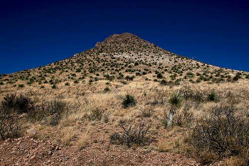
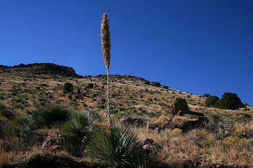
Schoolhouse Mountain has an elevation of 6,220 feet and a prominence of 320 feet and is one of ten named summits within a 6.5 mile radius of the Lake Valley townsite. Like other desert peaks in this area, the typical sharp and spiny desert plant life is present, although not in overabundance. This makes for more fun and less pain in reaching the summit.
NOTE: Schoolhouse Mountain is on private property and is part of the Ten Canyons Ranch. Permission must be obtained from the landowner.

Lake Valley
Lake Valley was a thriving silver mining town in the 1880s and with a population that peaked at 4,000, was one of the largest towns in New Mexico Territory. It is perhaps best known as the site of the richest lode of silver ever discovered, aptly nicknamed “The Bridal Chamber”. The silver in this mine was so pure that it did not require refinement, and a railroad spur leading to the mine shaft was constructed so that silver could be loaded directly onto the ore cars. After the devaluation of silver in 1893, Lake Valley, like other silver mining towns, saw a decline in production and population. The town eventually died and is today a BLM-managed historic site.Getting There
NOTE: Schoolhouse Mountain is on private property and is part of the Ten Canyons Ranch. Permission must be obtained from the landowner.From the southeast: From Interstate 25, take NM Hwy 26 approximately 20 miles, proceeding west through the town of Hatch; turn right onto NM Hwy 27 at Nutt Station (do not blink or you will miss your turn!) and proceed north for about 13.6 miles. You will pass the Lake Valley townsite to your right and Town Mountain to your left; turn left onto the gravel road (County Road B-005) just past Town Mountain. See Detailed Directions below for further info.
From the southwest: From Interstate 10 in Deming, take US Hwy 180 West and proceed north for 1.2 miles; proceed east on NM Hwy 26 for about 28 miles; turn left onto NM Hwy 27 at Nutt Station and proceed north for about 13.6 miles. You will pass the Lake Valley townsite to your right and Town Mountain to your left; turn left onto the gravel road (County Road B-005) just past Town Mountain. See Detailed Directions below for further info.
From the west or north: From NM Hwy 152, turn south onto NM Hwy 27 in Hillsboro and proceed about 17.4 miles; turn right onto the gravel road (County Road B-005) just before you reach Town Mountain. See Detailed Directions below for further info.
Detailed Directions: After making the turn onto County Road B-005 on the northeast side of Town Mountain, proceed northwest for 2.1 miles. Turn left onto County Road B-004 (changes to County Road B-003 after a short distance) and proceed west for 1.4 miles where you will see a USFS gate and a large entrance sign for the Ten Canyons Ranch; pass through the gate (remember to close it behind you) and proceed about 2.7 miles to the western base of Schoolhouse Mountain. This 2.7-mile stretch heads in a westerly general direction and will curve to the northwest. About 2 miles after the gate you will come upon the Parks Ranch. It looks like you’re headed up a private drive, but the road actually leads right past the ranch, so stay on it. About 0.2 miles past Parks Ranch, take a sharp right at the intersection. This road goes east toward Schoolhouse Mountain. The 2.7-mile stretch from the USFS gate ends at another USFS gate at the base of the mountain. You can either start your ascent near this gate, or you can go through the gate and follow the road around the south side of the mountain and to the east side. An ascent on the east side has about 80 feet less elevation gain.
The network of County, Forest Service, 4WD, and private roads in this area can be confusing. If you use GPS, I’ve included waypoints below in the GPS Coordinates section that should be helpful.
NOTE: After making the turn onto the gravel road off Hwy 27, as you proceed to your destination, please be aware that there are some private roads leading to residences and ranches. Please observe and respect the signs that are posted. Also, much of this land is open range land, so be careful.
Route to Summit
The summit can be gained by either the west or the east slope. Both routes are roughly 0.5 miles, with the west route having slightly more elevation gain (450 feet) than the east route (370 feet). Neither route has a trail, but route finding is easy and straightforward, and the cacti and shrubs are not dense.
GPS Coordinates
| Waypoint | Latitude | Longitude |
|---|---|---|
| Turn off from Hwy 27 | 32.72128 N | 107.57790 W |
| Turn RIGHT onto CR B-004 | 32.74259 N | 107.60334 W |
| Ten Canyons Ranch gate | 32.74001 N | 107.62789 W |
| Parks Ranch | 32.74723 N | 107.65861 W |
| Turn sharp RIGHT | 32.75053 N | 107.66100 W |
| USFS gate | 32.74982 N | 107.65346 W |