A Tale Of Two Ridgelines
It was early, but I had a lot to do. I was about to begin the most ambitious hike that I could imagine. It began as a what if, had transformed into a why not, and after months of consideration, preparation, and planning, I was ready to begin.
The San Bernardino Peak trailhead was dark. The moon was full, but low in the sky. I had settled on Sunday June 3rd specifically because of the brightness of the moon (plus the promise of cooler temperatures). I locked the car, hoisted my heavier than usual pack (27 lbs.) on to my shoulders and started walking.
I like to start off at a brisk pace. The time estimates I come up with are realistic, but not without a shadow of a doubt, so I like to go quickly for a while before I settle in, so I can get 3-3.5 miles in the first hour.
It soon became clear that, while the moon was full and bright, it was also already very low in the sky and was going to fall victim to the steep terrain. I had hoped to walk until sunrise without using a light, but after an hour or so, I took one out. I don’t mind hiking alone, but there was something about the darkness that was very unsettling to me. I began to think things like “what am I doing” and “why am I doing this”. With the light out, I felt a bit more in control. I could scan the trail and the surrounding forest and preoccupy myself more with benign observations than with daunting speculations.
I was happy to see the eastern horizon brightening (4:39), had gained almost 4000 ft., and was ready for a break.
When I stopped, I began to shiver almost immediately. I wasn’t hungry, but thought I should eat something. I was feeling a bit sick and wondered if I had pushed too hard. Again, doubt crept into my mind.
I started hiking again, determined not to over react, committed to a milder pace, and convinced that my illness was only temporary. By the time I reached San Bernardino Peak (6:34), I was already feeling better.
Soon East San Bernardino Peak came and went (7:06). It is always nice when the trail goes over the peak (rather than around the side of it). Next came Anderson Peak (7:50), then Shields (8:15), then Alto Diablo (8:40). I was making great time, the scenery was excellent, and the weather was perfect. I had made a pit stop and was feeling tip top.
As I approached the Dollar Saddle, Charlton Peak looked steep and difficult. I considered walking directly up the northwest slopes, but decided instead that I would take the trail around to the south, attain the saddle between it and Little Charlton, then get both of them with the greatest of ease (with some backtracking). I sat down at the Dollar Saddle and had a snack (9:11), then set forth to implement my plan.
With my plan implemented successfully, and Charlton Peak (9:55) and Little Charlton Peak (10:10) climbed, I turned my attention to Jepson Peak. I remembered the existence of Little Jepson Peak, but climbing it did not appeal to me. I took a similar approach as I did to Charlton Peak. I swung around to the south, and then turned north when the urge hit me. I was a bit premature, so I encountered a few false summits, but I wasn’t tired enough yet for them to bother me too much. When I signed the log book (10:57), I was amused to see that a fellow long-distance trekker was going for the 9 peaks too. We had missed each other by only 20 minutes. He must have thought more highly of Little Jepson Peak. I was amused again when I added “8 of 18” below his “2 of 9”.
I headed for San Gorgonio Mtn. There were plenty of people that were coming up on the Vivian Creek trail. I said hello, took a break on the peak (11:38), then left. I had been hiking for 8.5 hours, covered approximately 17 miles, and climbed 9 peaks. My spirits were high.
I was anxious about the next stage of my expedition. My plan was to take the Vivian Creek trail down to about 9900 feet, then abandon the trail and make for the Mill Creek Jumpoff. I had studied maps, poured over Google Earth, and solicited advice from a local hiker, so I was confident that my route would get me there, but unsure of the toll it might take on me. I expected it to be brushy and steep.
As I approached the moment of truth, I was focused. I knew that my ability to navigate the next mile would make or break my hike and that any mistakes could be very costly. Dropping down too soon would make more work for me, and dropping down too late would be devastating. True to form, I chose correctly. The downhill pounded my toes, I had a few close calls, and I watched with great dismay as the altimeter on my watch continued to go down. I already new that I was going to lose almost 2000 feet, but that didn’t make it any easier, especially as Galena Peak climbed higher and higher above me.
Galena Peak is the first peak on the Yucaipa Ridge and was now over 1000 feet above me (13:13).
I suffered, toiled, cursed, perspired, gasped, hunched, and burned my way to the top (13:55). It was a little disconcerting to feel so fatigued, knowing that an entire ridge lay before me. It was more disconcerting because I had been down the ridge before, and knew what the first 3 miles had in store for me.
The Yucaipa Ridge, from Galena Peak to Little San Gorgonio Peak is horrible. I despised ever inch of it. Rather than hold close to the top of it, I decided instead to stay lower down on the south side. I thought I could go faster, and maybe I did, but I also successfully decreased my views of the surrounding scenery, increased the amount of brush that I had to fight, and pushed myself closer to the edge of misery. Many times I found myself sprawled on the ground, agonizing, covered in dirt, bleeding from fresh scratches and pokes, and pessimistically considering the remainder of my route. I knew that, when I reached Little San Gorgonio, most of my troubles would be over, but I could see the jagged (and unnamed!) peaks that stood in my way, and I wasn’t happy about it.
Knowing that I had no choice, I made my way. Each gulley crossed, each patch of brush navigated, and everything in between was bringing me closer. Finally, as I approached the top of a peak, I saw the stumps and cut trees that I had remembered seeing on Little San Gorgonio. I was filled with joy. I hadn’t expected to reach it so soon. I enjoyed these newfound positive feelings. I enjoyed them right up until the point when I looked west and realized that I wasn’t standing on Little San Gorgonio (15:25).
I stood there, deflated, and looked at the steep slopes and intimidating crags of the unnamed peak that was next to be negotiated. I grasped at a few moments of denial, thinking somehow that I didn’t have to go over it to get to Little San Gorgonio.
It was a difficult climb. There were at least 2 false summits. I passed over the top (16:00) much like a breeze would have, that is of course if there was much of a breeze, which seemed to have abandoned me when I left the Vivian Creek Trail. A few more moments of brush-inspired despair and I was at the Camp Creek saddle.
From this point on I knew that I had more of a trail to follow. I knew that the climb to Little San Gorgonio was steep, but having done it twice already, I was confident that it could be completed with purposeful marching and by ignoring my burning legs, heavy breathing, and profuse sweating.
When I crumpled on the top of Little San Gorgonio (16:47) and started fumbling for the log book, I chuckled at the excessive bagging. Negative moments are often exposed as melodramatic when a simple observation solicits a light-hearted emotion.
Onward!
My next task was to trespass my way past some communication towers. In fact, however, I was not trespassing, having earned approved access through determination, respect, and the purchase of some buffalo meat.
Wilshire Mtn. is so close to the road that it diminishes its stature as one of the Yucaipa Ridge’s higher peaks. Its stature is further diminished by its humdrum top and proximity to a Wilshire Peak’s excellence. I will say that the boulder formation that houses the log book is very cool and feels a bit like a meeting place from Middle Earth.
My walk to Wilshire Peak was the easiest that it has ever been, mostly because I rarely climb it from the east, but partly because its summit has made a career out of ringing the last bits of energy from me and many other hikers as they approach it from the west (or south…). I didn’t spend very much time on top. I was looking at my watch more and more frequently and knew that I still had a long way to go.
I rambled down the west side of Wilshire Peak (17:45), worked harder than I ever have before to climb Oak Glen and Cedar Peak, and continued towards Birch. I had been going back and forth as to whether I would include Allen Peak and was starting to feel confident that I wouldn’t. I was already almost at my target duration and knew that I still had at least 2.5 hrs. left without including it and that I was struggling mightily on ever more insignificant uphill stretches.
I had a hell of a time getting over to Birch. In the past, I had stayed toward the north edge of the ridge, but knew (or at least thought) that the trail went more toward the south edge (to avoid needless climbing). I ended up enduring a bout of overcompensation, as I zigzagged back and forth across the top of the ridge, looking for the switchbacks that climb down to the saddle to the east of Birch Mtn. There were many new and increasingly difficult moments of pessimism, but I made it.
From the saddle to the east of Birch Mtn. I knew I had it made. I had only to climb up Birch, then pick up the trail back to the road that would take me home. Knowing that Allen Peak would have to wait for the next time I would attempt the hike (yeah right) I enjoyed the punch-drunk ecstasy of the last major climb of the day. I flopped to the ground on the top of Birch Mtn. at 19:28, 16.5 hours into the hike, and felt happy.
As usual, I missed the trail that leads down from Birch, and with much cursing and complaining, I backtracked uphill to find it. When I did, it was time to march. With approximately 6 miles left to stagger, I shifted into tired and wired mode. It was a fairly uneventful stretch of the hike, aside from a very painful toe stub and the enjoyable evening light.
When I got to the dirt road that leads down to Bearpaw, I was both happy and disgruntled. I knew that I had nothing but free and clear dirt road walking, but also knew that 4 miles of downhill would take at least an hour, but probably more like 1.25.
I marched, drank water, marched, worried about mtn. lions, marched, and got startled by the rising of the moon as it disrupted the fading light (it seemed like someone turned a flashlight on behind me).
After I passed the saddle to the east of Allen Peak, I decided to call my fiancée (Jlo). She had spent the day at her bridal shower, and being that I was in the process of taking longer than I thought, and with her being 3 hrs ahead of me (in Connecticut), I thought it was prudent.
Chatting with her for the last 1.5 miles was delightful. She told me how confused she was by what I had spent the day doing (being that it was both optional and agonizing) and I told her how I almost stepped directly on a rattlesnake as I paid less and less attention to the ground in front of me. I continued to give her unrealistic estimates of how much walking I had left to do, listened to accounts of her day’s activities, and thought about how crappy my 8am meeting would be the next morning in Oak Glen.
I came upon the parking lot and took my last painful steps at 21:27. I had walked 36 miles (?), climbed 18 peaks (16 named, and 2 unnamed), and had done it all in 18.5 hours.
The odyssey that had culminated with this hike (which I affectionately referred to as “The Mighty U”) had begun exactly one year earlier. On June 3rd, 2011, I had set out to hike the Yucaipa Ridge (from Vivian Creek, to Galena, to Birch, then down to Bearpaw) and had successfully completed it. At the time, I had thought it to be ambitious and intimidating. What followed was a succession of longer hikes, with more peaks, more elevation gain, and longer durations. I had climbed Mt. Whitney, done the San Gorgonio 9 Peaks Challenge, Cactus to Clouds, 10 Peaks on the Desert Divide, and the 10 Baldy-area peaks (to name some of my more impressive achievements). I had started a hiking club, met many cool people, and learned a lot about hiking and about myself. From the time that I first considered attempting “The Mighty U” I had been like a bullet fired from a gun. I had planned, prepared for, and focused on what I perceived to be an ultimate day-hike challenge, and had progressed towards it with excited commitment and firm purpose.
I am proud of my accomplishment. I regret only that I couldn’t carry enough water for Luna to come, that Paul didn’t go, and that I didn’t continue to Allen and Mill Peak and down the remainder of the Yucaipa Ridge to Highway 38 (at the SCE Hydro-electric station), which would have been more logistically pleasing. I would also like to thank Marianne and Steve for shuttling my car for me and to everyone that humored my premature boasting and periodic blabbering regarding this hike in the weeks and months leading up to it.
Onward and Upward!
Evan Welsh
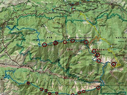
Start - 3:06
San Bernardino Peak - 6:34
East San Bernardino Peak - 7:06
Anderson Peak - 7:50
Shields Peak - 8:15
Alto Diablo Peak - 8:40
Charlton Peak - 9:55
Little Charlton Peak - 10:10
Jepson Peak - 10:57
San Gorgonio Mountain - 11:38
Galena Peak - 13:55
Cuchillo Peak (proposed name) - 15:25
Wanat Peak (proposed name) - 16:00
Little San Gorgonio Mountain - 16:47
Wilshire Mountain - 17:15
Wilshire Peak - 17:45
Oak Glen Peak - 18:00
Cedar Peak - 18:20
Birch Mountain - 19:28
Finish - 21:27

Comments
Post a Comment