Spring in the San Bernardino Mountains is beautiful and unpredictable
I had planned to do a snow ascent up the north face of San Gorgonio Mountain and was encouraged when it snowed two weeks prior, and concerned when it reached 70 degrees a week later. Or was it the other way around? As the saying goes in the mountains, if you don’t like the weather, wait a few hours. All of which makes trip planning a bit trickier. We knew we would encounter some snow since you could still see significant snowpack on the North side of San Gorgonio from Big Bear, and typical night time temperatures in at least the 30s, but beyond that, who knew. Tee shirts? Down jackets? Snowshoes? Crampons? Yes. All of them.
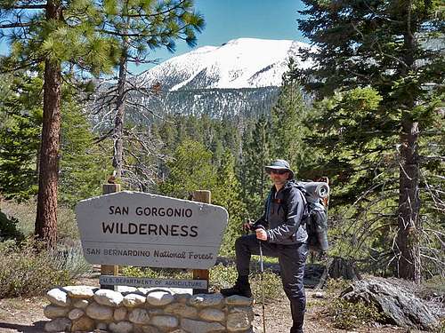
![San Gorgonio Wilderness]()
After parking at the South Fork trailhead, we began up South Fork Trail on Easter Sunday (4/24/11) with plans to hike 6 miles to Dry Lake, overnight, and then do a steep summit push 2 miles up the north face of San Gorgonio Mountain, the highest point in Southern California. Given that it was early Spring, still snowy, and a holiday, we figured we wouldn’t see many people and were surprised to pass several parties heading down the trail geared up for winter ascents. Some we stopped and talked to, others we just smiled at as they passed.
We were even more surprised to see San Gorgonio Wilderness Association Volunteer Rangers doing some trail maintenance. They had their work cut out for them as the previous Winter was hard on the South Fork Trail causing numerous downed trees. Because Federal Wilderness rules prohibit any kind of mechanized equipment, the large trees we climbed over would have to be cut by hand with a large two man saw. The thought of hours of old-school sawing made me appreciate the chain saw we had used a few days earlier to clear deadfall on Cougar Crest Trail in Big Bear. The Rangers asked us for our Wilderness Permit even though we weren’t yet technically in the San Gorgonio Wilderness area. I had heard that even in Winter you may come across permit-inquiring Rangers, so was glad to present my free permit I had gotten from the Mill Creek Ranger Station.
After two miles we passed the signs indicating the Wilderness Boundary and were soon shocked to see the results of an avalanche from the previous Winter. It went relatively low – less than 8000′ – just pass Poopout Hill. A sea of downed trees snapped off at their bases littered the canyon. That year we had record snow fall in Big Bear and suspected one of those storms caused this destruction. Imagine – avalanches in Southern California. And a reminder how this Wilderness can be unforgiving.
Soon our sunny skies disappeared as clouds began to roll in. The weather report had called for a 30% chance of precipitation with snow levels around 8000′ and gusts to 50 mph. Thirty percent chance. Hmmm. For now it remained calm and cool as we crossed several streams indicating our arrival at South Fork Meadows. At this point we would leave the trail and head up the Winter Route via the drainage below Dry Lake. The amount of snow increased, but not consistently enough to encourage the snowshoes we carried. Numerous tracks made our way easier and usually prevented postholing (when you sink down deep in the snow like a post going in a hole), but not always.
A breathtaking view awaited our arrival at Dry Lake, which wasn’t very dry, and was backed by the snowy ridgeline we would climb to the next day. We found a bare patch of ground well below Lodgepole Springs and made camp. I got to try out some new gear, including an ultralight tarp and bivy set up. At one point Matt asked me if I could hear running water, and I thought it sounded like ocean surf. We realized that on the ridgelines above us, the increased wind caused the sound and violently whipped the pines back and forth. It wasn’t especially windy where we sat, but as the sun dropped, the temperature dropped and the wind increased, causing an uncomfortable windchill. We guessed the windchill measured easily in the twenties or even teens. We were prepared for cold with down garments and hats and gloves, but standing around in the wind turned unpleasant and forced us into our bags as darkness fell. It usually takes me a night or two to adjust to sleeping on the ground, and the 1/2″ ultralight foam pad didn’t help. The wind died in the middle of the night and a warm cup of coffee the next morning was especially welcome.
After some breakfast, we repacked our bags for the summit, leaving our overnight gear at camp. The plan was to head straight up the snow to the top of San Gorgonio, gaining 2800′ of altitude. We debated whether we should start with just boots, crampons, or snowshoes. The snow surface was hard from the overnight freeze and we first had a mile of not-so-steep climbing. Matt made the good call of snowshoes, and we ended up shoeing all the way to the summit. Some icy spots near the top were a little sketchy in snowshoes and I made note to use crampons on the way down. (I later found out that some Big Bear acquaintances had lost their footing on ice near the top and fell severely enough to require evacuation.) We followed tracks up one of the East-most chutes and noticed some skiers climbing below us. It is not uncommon for people to climb up and ski down one of the bowls, an activity that has taken place since the 1930s. As we climbed, the forest dropped away with the views, incline, and wind all increasing. And so did the huffing and puffing.
Upon reaching the ridgeline, blasts of wind worked to push us over. These gusts at least matched the forecast of 50 mph and made travel along the ridgeline to the summit a bit tricky. We quickly signed the register in the metal box at the summit of San Gorgonio, elevation 11,503′, and found an exposed shelter made from piled rocks to get out of the wind. I tried to send a photo via my cell phone, but didn’t have a strong enough signal when hunkered down in the shelter. After warming in the sun for a bit, we put on crampons, fought our way through the wind along the summit ridgeline, and made quick progress on the same route back down to Dry Lake.
We were pleasantly surprised by our time to the summit because we had conservatively allowed 6 hours to do what ended up taking just 3.5 hours. However my quads were not pleased. After packing our Dry Lake camp and having some lunch, we headed back down the South Fork Trail to the parking lot we had left 28 hours earlier.
View trip stats, route map, and lots of photos at:
http://www.bigbeartrails.com/san-gorgonios-north-face/.
Comments
No comments posted yet.