
|
|
Route |
|---|---|
|
|
53.11701°N / 3.99645°W |
|
|
Scrambling |
|
|
Spring, Summer, Fall, Winter |
|
|
Most of a day |
|
|
Scrambling to Grade 1 Winter Climbing to Grade II |
|
|
Overview
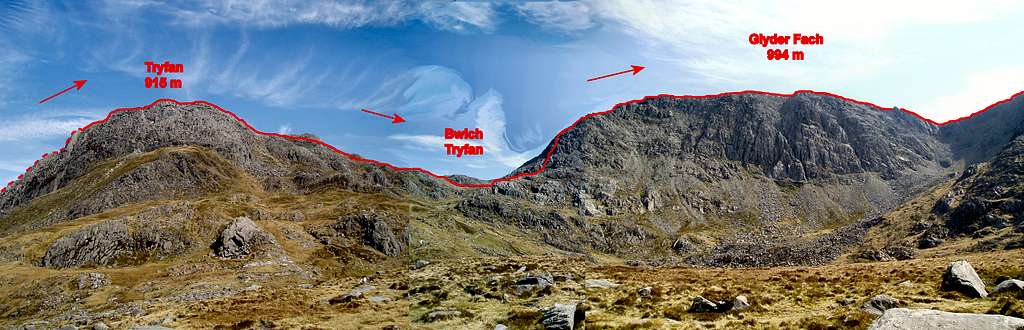
If the Snowdon Horseshoe is considered to be the one must-do classic route in Snowdonia, then the Bochlwyd Horseshoe must come a close second. In many people's opinion, myself included, it may be considered the finer of the two, consisting of two of the area's best scrambles, in addition to two less qualified ones, although even these are not without their own merit. The scrambling is, arguably, of better quality than that of the Snowdon Horseshoe, which derives most of its excitement from the narrow ridge of Crib Goch, which although exposed, will present little difficulty for the experienced scrambler.
Bochlwyd’s scrambling, however, varies between exposed arêtes, narrow gullies and broad ridges, which offer plenty of options for increasing or decreasing the difficulty of the climbing and is suitable and enjoyable for novice and experienced scramblers alike. In winter much of the route becomes a superb Scottish Grade II climb, and presents further challenges for the winter mountaineer. The route only really lacks the grandeur that Snowdon presents, and only very narrowly, as it visits the summits of Tryfan (915m) and Glyder Fach (994m), both iconic Welsh mountains, both of which offer panoramic views across all of northern Snowdonia’s highest and most spectacular mountains.
Getting There
Conveniently, the route begins on the A5 meaning that there isn't a long approach to the bottom of the mountain, making it one of the most accessible routes in Snowdonia.
If approaching from the north or west, e.g. from Liverpool or Hollyhead, turn off the A55 and onto the A5 at the large junction (SH 593 694) that sign posts for Bethesda and follow the road until Llyn Ogwen where parking is available.
If coming from the east, take the A5 through Bettws y Coed (SH 798 599) and Capel Curig (SH 719 580), which will take you directly to the base of the mountain.
If driving from the south, take the A470 through Blaenau Ffestiniog (SH 700 458) to Bettws y Coed, and turn off onto the A5 towards Bethesda which will take you the same way as if coming from the east.
 Castell y Gwynt (Photo by vancouver islander)
There is plenty of parking along the A5 near Tryfan, some of which you have to pay for, some of which you don't. My advice is to never bother with the official car parks and just park along the roadside. There is a wide 'pavement' type verge on the southern side of the road that can easily accommodate the width of a car or minibus, and is completely free and never full (even on bank holidays). It also allows you to park even closer to the base of the mountain and the start of the path.
Route Description
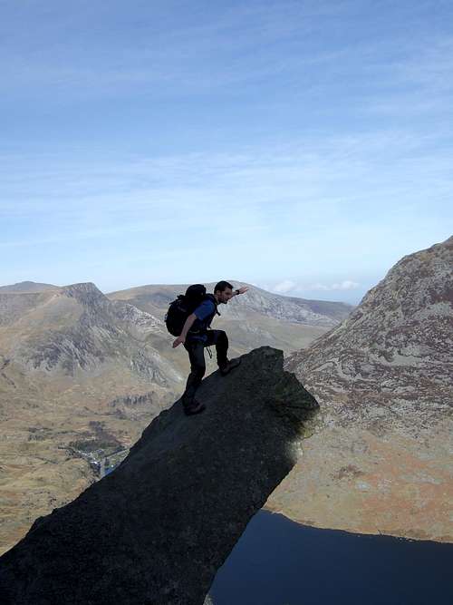
The route starts wherever you park the car, or if you don’t drive, wherever your dropped off, along the A5, so the nearer you are to Tryfan the better. The Milestone Buttress (a prominent feature on the lower west side of the ridge) can be seen from the road, and the route heads towards it slightly to its left (east) where it gains the shoulder of Tryfan’s North Ridge. Then ascend though a boulder-strewn slope and breaks through a short a barrier at its top. Continues slightly to the left side of the ridge to a quartz platform. Slightly to its right The Cannon can be found, a famous rock feature that protrudes from the ridge. Make sure you get a photo of yourself on it and then crop it so it looks like your standing over an enormous precipice, a shot that will definitely impress your non-mountaineering mates down the pub!

From The Cannon carry on climbing, beginning by heading slightly to the left of The Cannon up a high crag and continue to another platform just before a prominent nose of rock. Its best to carefully inspect this barrier for the best line and then follow it over polished rock to Tryfan's North Summit, the route then descends the far side of the summit to The Notch.
Head right, out of The Notch, and ascend a gully to the north of the summit, continuing easily over scattered boulders to Tryfan’s true summit, and the twin boulders Adam and Eve.

The descent along Tryfan's South Ridge
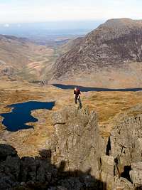
From the summit head south to descend along Tryfan’s shorter, broader and easier South Ridge. The descent should provide no difficulties even when wet, and a well trodden path of loose rock provides an obvious line to the pass of Bwlch Tryfan. On reaching Bwlch Tryfan you will have completed the first half of the route and standing before you should be the imposing buttress of Bristly Ridge. The pass provides a good point to end the route if a member of your party is waning, or if the weather is turning drastically for the worse. A quick descent can be made along Tryfan’s western flank, past Llyn Bochlwyd, and back to the A5.
If continuing, from Bwlch Tryfan, begin by following the stone wall that runs along the pass to the base of the ridge. From the foot of the lowest crags climb 10m right and ascend a short gully, existing left over another wall to the foot of the imposing Sinister Gully. Some careful scrambling is required here detouring onto the left wall where the route steepens before escaped onto easier ground. There is quite a lot of loose rock in the gullies and care is needed in order to avoid dropping large stones on anyone climbing below you.

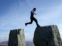
Continue up a slabby shoulder and onto an increasingly narrow ridge, and climb over a small pinnacle followed by a second lager one and before descending into the prominent notch of Great Pinnacle Gap. Escape up a short wall just right of the slender Great Pinnacle (take time to stop and get a picture of yourself on the pinnacle, the exposure is awesome), and then pass through a gap between a small pinnacle followed by the main body of the ridge to reach easier ground. An elevated boulder pavement leads onto the summit plateau. From the top of the ridge head south-west to join the normal route up Glyder Fach and follow a path to the summit tor.
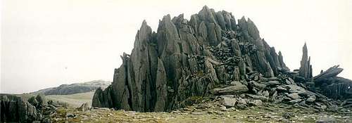
From the summit of Glyder Fach, head west past the impressive tor of Castell y Gwynt, and follow a broad path towards Glyder Fawr. Descend of some 50m into Bwlch Ddwy Glyder, which separates the two mountains, and climb a height of some 30 on the other side, leaving the path and hugging the edge of the cliffs that fall into Cwm Cneifion. You will soon be bought round to the top of Gribin Ridge, by which you will make your descent. The ridge is broad, and offers a bit of route choice. The eastern side, close to the ridges crest holds the best scrambling (up to grade 2 in places) and in places is very exposed. It is probably unsuitable for the inexperienced, or when the weather is bad, luckily the ridges western side offers an easier alternative (firmly grade 1). On the lower section of the ridge, stay on its eastern flank to be sure of finding the Llyn Bochlwyd overflow and the path back to the road.
Essential Gear
During the summer you will need all the equipment you would normally use on a Grade 1 scramble i.e. a good pair of boots and full waterproofs. A rope and helmet may be required for the inexperienced or those without a head for heights.
If your lucky enough to climb the route in winter conditions then an ice axe (or ice axes), crampons, a helmet, a rope and a decent winter rack (if going for a more serious line) are all essential.
Maps
Navigation Maps
OS 1:25k Explorer Series OL 17 Snowdon/Yr Wyddfa
OS 1:50k Landranger Series 115 Snowdon/Yr Wyddfa
Harvey Map Services 1:25k: Snowdonia North: Snowdon, Glyders, Carnedds
Harvey Map Services/BMC 1: 40k British Mountain Map: Snowdonia North
Road Maps
OS Travel Map 10 Wales/Cymru & West Midlands
Guidebooks
General
Snowdonia: The Official National Park Guide
Cicerone Guide: The Mountains of England and Wales: Volume 1 Wales
Scrambling
Cicerone Guide: Ridges of Snowdonia (Also includes hiking routes)
Cicerone Guide: Scrambles in Snowdonia
Cicerone Guide: The Ridges of England, Wales and Ireland (Also includes rock climbs)
Northern Edge Books: North Wales Scrambles
Scrambles and Easy Climbs in Snowdonia (Also includes rock climbs)
Winter Climbing</p align="left"> Rockfax Guide: North Wales Classics (Also includes winter climbs)
Cicerone Guide: Welsh Winter Climbs
Ground Up Guide: North Wales Winter Climbing
External Links
Government Bodies and Official Organisations
Snowdonia National Park Authority
Association of National Park Authorities
Royal Commission on Ancient & Historical Monuments in Wales
Hiking, Climbing and Mountaineering Organisations and Companies
British Mountaineering Council
Plas y Brenin National Mountain Centre
Weather
Tourist Information
North Wales Tourism Partnership
Local Information from Gwynedd.com
Local Information from Snowdonia Wales Net
Travel
Welsh Public Transport Information
Accommodation
Youth Hostel Association in Wales
Maps and Guidebooks
Cordee Travel and Adventure Sports Bookshop
Wildlife and Conservation
Joint Nature Conservation Committee
Royal Society for the Protection of Birds