
-
 11384 Hits
-
 84.82% Score
-
 19 Votes
|
|
Mountain/Rock |
|---|---|
|
|
38.64480°N / 78.2891°W |
|
|
Hiking |
|
|
Spring, Summer, Fall, Winter |
|
|
2655 ft / 809 m |
|
|

Overview
Buck Ridge is a named ridge that is an offshoot of the main crest of the Blue Ridge near Marys Rock in Shenandoah National Park. From U.S. 211 west of Sperryville, it rises and then runs southwest for about three miles until it reaches Skyline Drive, where, if one wants to interpret the map so, it continues climbing a short distance before joining the range crest a little south of Marys Rock.
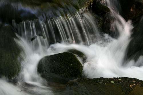
Combined with adjacent Buck Hollow, Buck Ridge makes for an excellent day hike through some characteristically scenic Shenandoah country. Ones does not hike here for the views, which are few and partially obstructed even in winter, but rather for the streams, the wildflowers, the old trees, and the serenity. The stream coursing through Buck Hollow has no waterfalls, but its mossy rocks, clear pools, and many small cascades make it the archetypal mountain stream of the southern Appalachians.
The fact that the Buck Hollow-Buck Ridge loop has no waterfalls or significant views also makes it far less crowded than many other SNP trails of comparable beauty. Park visitation has increased in recent years, however, and Buck Hollow is no longer the secret it once was, so do not show up between 10 and 5 on a nice spring or fall weekend and expect to find a parking spot.
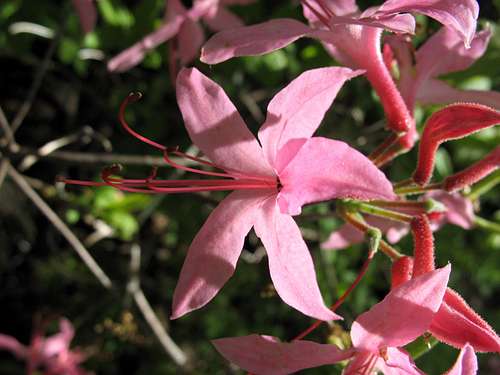
The scenery here is best in May and early June, when wildflowers are seemingly everywhere, and mid-October through early November, when fall colors peak.
The elevation given here is for the highpoint of Buck Ridge Trail.
Getting There
There are two ways to access Buck Hollow and Buck Ridge. The first is from the Meadow Spring parking area about two miles south of the park's Thornton Gap Entrance Station (this is the second of the park's three access points for Skyline Drive, from north to south, and it is where U.S. 211 crosses the crest of the range). The second is from outside the park. Just west of the signed park boundary on U.S. 211 west of Sperryville, look for a small parking area on the south side of the road. A concrete post indicates access for Buck Hollow.
If you are hiking in winter, it is probably better to plan to start from the lower end since Skyline Drive might be closed.
Route Description
Because the bottom part of the Buck Ridge Trail is very steep (35-degree grade at times), it is best to hike up Buck Hollow and down Buck Ridge (hikers starting from Skyline Drive may wish to go down Buck Ridge and up Buck Hollow), and it is this route, starting from the parking area off U.S. 211, that I will describe here.
The distances are based on the PATC guidebook for Shenandoah National Park; my GPS device suggests the route is somewhat shorter. The lower end of the trail is at 1100' elevation, and the upper end is at 2840'.
From the parking area off U.S. 211, hike on Buck Hollow Trail for 0.2 mi to its intersection with Buck Ridge Trail, which branches left. Keep right. Note-- the beginning of the trail fords Thornton River (really a stream). This is usually an easy crossing made even easier by large rocks whose tops are well above stream level, but be aware that periods of heavy rain or snowmelt could make the crossing difficult, dangerous, or impossible.
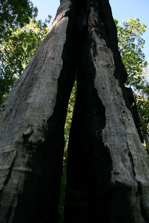
 Thornton River
Hike Buck Hollow Trail for 2.8 mi all the way to its end on Skyline Drive at Meadow Springs Gap. Highlights along the way include a small gorge (at 1.4 mi, just after a stream crossing) and many small cascades. There are some stream crossings, but the steepness of the terrain means that the stream is rarely deep enough to provide a challenging crossing, and there are usually large stones spanning the stream, anyway.
Follow Hazel Mountain Trail 0.4 mi downhill to its junction with Buck Ridge Trail. Turn left onto that trail. Follow it for 2.4 mi back to the junction with Buck Hollow Trail, from which it is 0.2 mi to the trailhead. The first half of Buck Ridge is a hiker's delight; tracing the ridge's crest, the trail passes through semi-open forest graced with profuse stands of mountain laurel and pinxter flower (the latter is a pink species of azalea that resembles honeysuckle and smells almost as sweet), and those plants bloom late May-early June and mid-/late May, respectively. There are no unrestricted (camera-friendly) views, but the forest is open enough to allow nice hiking views north, east, and south, as well as west across Buck Hollow to the cliffs of Marys Rock.
Total distance by guidebook: 6 miles.
Red Tape
Keep an eye out for copperheads, timber rattlesnakes, and poison ivy. Late spring through summer, carry insect repellent or prepare to swat and/or itch a lot.
It costs $15 to enter the park, and that provides access for a week. Annual passes cost $30. The interagency pass, good for year-long entry to areas managed by NPS, USDA Forest Service, USFWS, BLM, and the Bureau of Reclamation, costs $80.
The park is open all year, but Skyline Drive does sometimes close after snow or ice storms. The park site does not give current road conditions, so call ahead (540-999-3500).
To reduce poaching, Skyline Drive is subject to nighttime closures during hunting season (mid-November through early January). Specific information about the dates, times, and sections for the current year is available on the park's website.
Camping and Lodging
The closest campgrounds inside the park are at Mathews Arm (MP 22, north from Thornton Gap) and Big Meadows (MP 52, south from Thornton Gap). Thornton Gap is at MP 33.
Mathews Arm is open from late May through October. The campground has water and flush toilets but no showers or a store (there is a seasonally open snack bar at Elkwallow, a short drive south on Skyline Drive). It will usually fill on holiday and October weekends. The fee for a campsite is $15 per night.
Big Meadows Campground is at MP 52 and usually opens in March and stays open through Thanksgiving weekend. You can reserve sites here, and the campground has showers and a store in addition to water and flush toilets. Tent sites go for $20 a night.
Backcountry camping is free, but you must get a permit. You can self-register at entrance stations.
Spring through fall, lodging is available inside the park at Skyland, Big Meadows, and Lewis Mountain (all in the Central District).
Links
Official park site
Camping info
Lodging info
PATC maps and guide
