
-
 7631 Hits
-
 84.27% Score
-
 18 Votes
|
|
Mountain/Rock |
|---|---|
|
|
38.55080°N / 78.32306°W |
|
|
Bouldering, Scrambling |
|
|
Spring, Summer, Fall, Winter |
|
|
2850 ft / 869 m |
|
|
 From the Saddle Trail
 The "summit boulder"
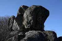 The "summit boulder"
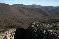 Summit view
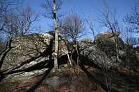 Outcrop behind Byrd's Nest Shelter
 Outcrop behind Byrd's Nest Shelter
 Byrd's Nest Shelter
Overview
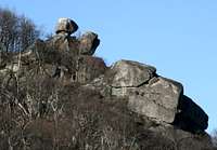
Everyone hiking the Saddle Trail on Old Rag Mountain sees the Byrd's Nest Crags; they are prominently visible from several locations both above and below the crags. The most striking crag has a "balanced rock" appearance and is the one referred to in picture captions here as the "summit boulder." The trail at times seems headed straight for the crags, but this is just a tease. It is easy, though, to reach the crags from Byrd's Nest Shelter, which is beside the trail less than a mile from Old Rag's summit.
There are three outcrops near the shelter; the one farthest from it is the dramatic one seen from the trail. Although the outcrops hold some short toprope possibilities, they are really suitable for bouldering and scrambling.
Approach
From the trailhead at 1500' (see driving directions below), hike approximately two miles to Byrd's Nest Shelter. This is a three-sided shelter available for day use only. The rags will be visible from several locations along the way; one excellent viewpoint is from an open slab shortly beyond the first set of stone steps along the trail as one ascends it. There is another good viewpoint from a prominent switchback just minutes away from the shelter; this switchback is near the base of the crags, and the adventurous may wish to scramble and bushwhack their way to the crags from it.
Between this first outcrop and the crags themselves is another outcrop that offers some scrambling, bouldering, and perhaps some toproping. The wall that you pass on the way to the crags is probably a little too high and sheer for the comfort levels of most boulderers, but it has some interesting, though short, toproping possibilities. Note-- it is illegal to place new bolts in the park.
The crags themselves are just a few minutes away. The highest boulder is pretty easy to climb; it is probably too hard for most people who have not gone past Class 3, but anyone used to harder things will not have a hard time pulling himself or herself up top. The easiest way up has some exposure, but a fall is likely to just hurt, not kill; with luck, a fall will result in no worse than some bruises and other sore spots.
Do not confuse Old Rag Shelter from Byrd's Nest Shelter; the former is lower on the trail and has no climbing opportunities in the vicinity. Both shelters have signs identifying them.
The Crags
Just behind the shelter is one outcrop that is easy to reach, has nice views, and is fun for casual scramblers and kids. From the higher rocks there, the subject crags are visible a short distance away. Reaching them required a little bit of easy bushwhacking in early April, but it could be considerably more tedious to reach the crags May through October.
There are two established bouldering routes in the vicinity: Chockstone Crack (V0, 14') and Spirit (V3, 12'). For more information on their locations and features, see this page on rockclimbing.com.
If you're more like me and just want to have some fun and and aren't too worried about following some exact line someone else established, then just throw some rock shoes in the pack, head out here, and use your imagination. Enjoy!
Getting There
At Sperryville along U.S. 211, look for signs indicating 522 and 231 and follow the directions to them. Turn right on 231. You can also reach 231 via 522 from Culpeper, and you can take 231 all the way from Charlottesville. After about 10 miles along 231, you reach a tiny town called Etlan. Look on the east side of the road for a small convenience store. Directly across the road from the store is SR 643. There should be a sign indicating access to Whiteoak Canyon. Follow this road for about 4 miles until you reach a stop sign. Turn right (a sign for Whiteoak Canyon should confirm this). You are now on SR 600, and it takes you all the way to the signed parking area and trailhead, almost at the very end of the road. Instead of turning into the parking area, continue straight for about 0.8 mi to the end of the road, which is where the Berry Hollow Fire Road begins. It is about 5 miles from the junction of 643 and 600 to the trailhead, and the drive takes about 15-20 minutes.
The most popular approach to Old Rag is via the Ridge Trail from Weakley Hollow on the other side of the mountain. Climbers solely interested in the crags covered on this page will not want to use this approach because it is longer and more strenuous, requiring a trip to the summit and then a descent to the crags. This approach might appeal to scramblers wanting to make a circuit of the mountain via the Ridge Trail and the Sunset Walls, though, as an early start up the Ridge Trail will enable one to avoid the crowds that usually appear on the trails here. People interested in that circuit should consult the main Old Rag page for driving directions.
Red Tape
March through November, there is a per-person entry fee of $8; December through February, the fee is $5 (the maximum for family groups is $15 and $10, respectively. Payment is mostly on an honor system, but rangers do collect fees on weekends at Berry Hollow.
No pets allowed. Remember that as much as you love your dog, it is still considered a pet. People routinely violate this restriction; please don't join them.
Be prepared for poison ivy, and be wary of rattlesnakes.
Camping
There are no campgrounds at or near Berry Hollow and Weakley Hollow, but people do sleep in their cars at the trailheads. Backcountry camping is not allowed on Old Rag above 2800'; a sign at Byrd's Nest Shelter indicates that there is no camping allowed beyond (above) it. Free backcountry camping permits are required, and they are obtainable by self-registration at the trailheads.
External Links
Shenandoah National Park Telephone: (540) 999-3500
Official park site