
-
 7603 Hits
-
 85.36% Score
-
 20 Votes
|
|
Mountain/Rock |
|---|---|
|
|
38.55170°N / 78.316°W |
|
|
Trad Climbing, Sport Climbing, Toprope, Bouldering, Scrambling |
|
|
Spring, Summer, Fall, Winter |
|
|
3100 ft / 945 m |
|
|
An Old Rag Climbing Crag

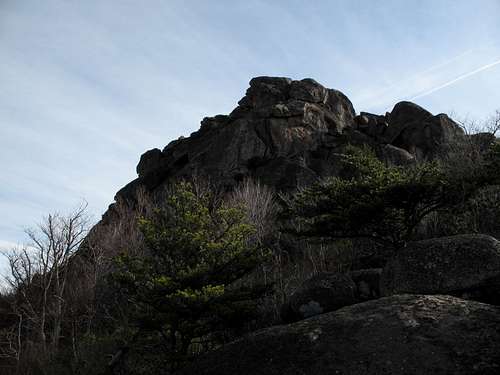
View of Upper Sunset
Overview
On the west side of Old Rag Mountain, there is a three-tiered area of cliffs, slabs, and boulders called Sunset Walls. The crags hold sport, toprope, and trad routes ranging from 5.5-5.12c and up to 50’ long. The Sunset Walls are also an obviously promising bouldering destination, and there are many scrambling opportunities ranging from Class 3 to easy Class 4. In fact, Class 3 and 4 moves are required just to get from one tier to another.
The Sunset Walls mostly face west and are therefore a fine afternoon location. Do note that winter temperatures may be very cold and that summer days can be too hot and humid for comfort. And depending on the season, there will be anywhere from easy to difficult bushwhacking. The best times to visit the Sunset Walls are therefore mid-October, November, late winter, and early spring (by late May, approach routes may be too overgrown for safe and painless passage).
Whether you go to the Sunset Walls to climb, boulder, or scramble, you will find a solitude that is almost impossible to find on Old Rag’s established hiking routes. The Sunset Walls are off the main trails and are unknown, though seen, by most hikers and even many climbers.
The trick is finding the Sunset Walls without wandering about the east face of the mountain. Directions I have found online and in guidebooks seem detailed enough, and a friend and I had no difficulty locating Lower Sunset Wall, but the ways to the middle and upper tiers are not nearly as obvious as written instructions make them seem.
It is not the purpose of this page to list or describe the many established routes on these crags. Climbers interested in such details should consult Eric Horst’s Rock Climbing Virginia, West Virginia, and Maryland, the first chapter of which is devoted to the climbing on Old Rag; climbers can also read this page on rockclimbing.com, which includes ratings, climbing logs, and a few photographs of climbers on the routes. The principal purpose of this page is to give an overview of the area and the options available, to present it as an alternative route to the summit of Old Rag and as a destination itself, and to provide location information based on photographs and personal observations.
View of Middle Sunset
Scrambling Route: Sunset Walls to Old Rag Summit
A short distance below the summit of Old Rag, the Saddle Trail passes close to the top of Upper Sunset Wall (to the right of it). Because of this, a route up Old Rag via the Sunset Walls is an adventurous alternative to the popular Saddle Trail, which is all hiking. The Sunset Walls route is also an excellent alternative to the crowded Ridge Trail on the northern and eastern sides of the mountain; the Sunset Walls route is shorter, begins from a higher trailhead and has harder scrambling, great views, and a wilderness feel that the Ridge Trail does not.
Also, from the base of Upper Sunset, one can hike and scramble to the left of the cliffs and then above them, after which it is a short distance to the crags directly beneath the summit of Old Rag (they come into view once you reach a small pillar called Old Rag Gendarme, which has a bolted line on it). There are two photos of Old Rag Gendarme on this page that one can use for reference.
The best trailhead to use is at 1500’. The base of Lower Sunset Wall is at about 2700’. Old Rag’s summit is at 3268’.
The distance to the summit via Berry Hollow Fire Road (see directions in the next section), the Saddle Trail, and the Sunset Walls is about 2.5 mi. Distance from the summit back to the trailhead via the Saddle Trail is 2.8 mi. Around and within the Sunset Walls, expect Class 3 and 4 scrambling and some bushwhacking. Parts of the area, especially around Lower Sunset Wall, receive little sun and may be icy in the winter, and the ice is sometimes hard to detect because of moss and other vegetation.
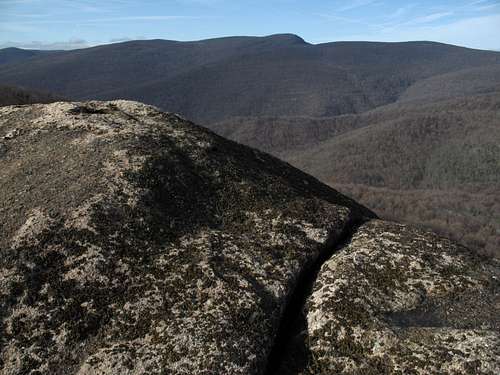
Slab and view
Getting There
At Sperryville along U.S. 211, look for signs indicating 522 and 231 and follow the directions to them. Turn right on 231. You can also reach 231 via 522 from Culpeper, and you can take 231 all the way from Charlottesville. After about 10 miles along 231, you reach a tiny town called Etlan. Look on the east side of the road for a small convenience store. Directly across the road from the store is SR 643. There should be a sign indicating access to Whiteoak Canyon. Follow this road for about 4 miles until you reach a stop sign. Turn right (a sign for Whiteoak Canyon should confirm this). You are now on SR 600, and it takes you all the way to the signed parking area and trailhead, almost at the very end of the road. Instead of turning into the parking area, continue straight for about 0.8 mi to the end of the road, which is where the Berry Hollow Fire Road begins. It is about 5 miles from the junction of 643 and 600 to the trailhead, and the drive takes about 15-20 minutes.
The most popular approach to Old Rag is via the Ridge Trail from Weakley Hollow on the other side of the mountain. Technical climbers will not want to use this approach because it is longer and more strenuous, requiring a trip to the summit and then a descent to the Sunset Walls. This approach might appeal to scramblers wanting to make a circuit of the mountain via the Ridge Trail and the Sunset Walls, though, as an early start up the Ridge Trail will enable one to avoid the crowds that usually appear on the trails here. People interested in that circuit should consult the main Old Rag page for driving directions.
Lower Sunset Wall
To find Lower Sunset Wall, hike up Berry Hollow Fire Road for 0.8 mi to a trail junction, where you head right onto the Saddle Trail. In about 1.2 mi, approximately half a mile past the Old Rag Shelter, you hike through a narrow rock passageway (pictured below) and then reach some stone steps (also pictured below).
As the trail climbs the steps and bends sharply right, look for a slab on your left (also pictured below). There is supposed to be a cairn on this slab, but there was not one in December 2008. However, if you climb onto the slab or step up on a nearby rock, you will see a cairn just beyond the slab (visible in the photo if you have really sharp eyes or if you zoom in enough). Follow cairns and a faint trail for about 100 yards to the base of a large rock outcrop. Some descriptions refer to a ridge here, but it is an outcrop, not a true ridge. Turn right and hike uphill along the base of the outcrop, still following cairns, for about 100-150 yards to a level break. Then turn left and hike a short distance downhill to the base of Lower Sunset Wall. The “trail” splits here; left leads down and around the wall to a few routes, but most routes are directly ahead and to the right. Going right also leads to the access points for Middle Sunset Wall.
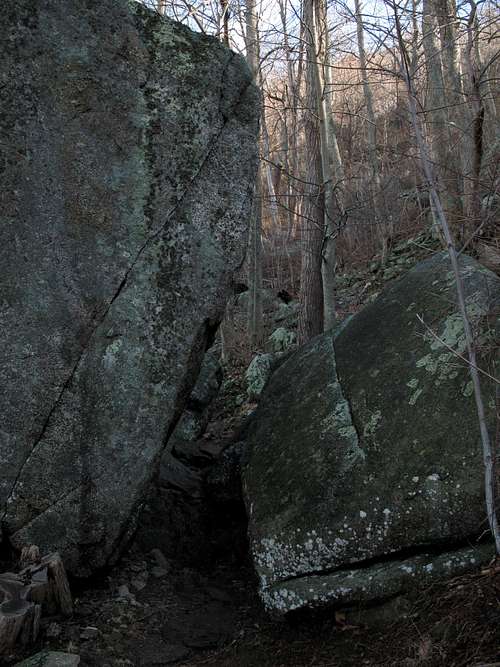
Finding Lower Sunset...Passageway...
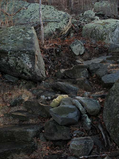
Steps...
Slab
Note: There are three sets of stone steps on the Saddle Trail. The steps that mark the departure point to find Lower Sunset Wall are the lowest of the sets. If you are approaching the Sunset Walls from the Ridge Trail, the first set of steps you encounter will have some strong resemblances-- the slab right by the sharp bend to the right (facing uphill)-- to the spot described above, but it is not the access point. Keep hiking downhill until you reach the third and lowest set of steps.
Several routes at Lower Sunset Wall are sport routes, and most of the bolts and anchors look clean and relatively new. The hardest and arguably the best route at Lower Sunset Wall is 5.12c Super Sunset Crack, which, at 50’, is also one of the longest. This line is a short distance to the right of the trail fork at the base of the wall. Guidebook author Eric Horst writes that there are a couple of fixed stoppers and a pin, and he recommends having a few small cams for the beginning and the end.
Lower Sunset Wall
Middle Sunset Wall
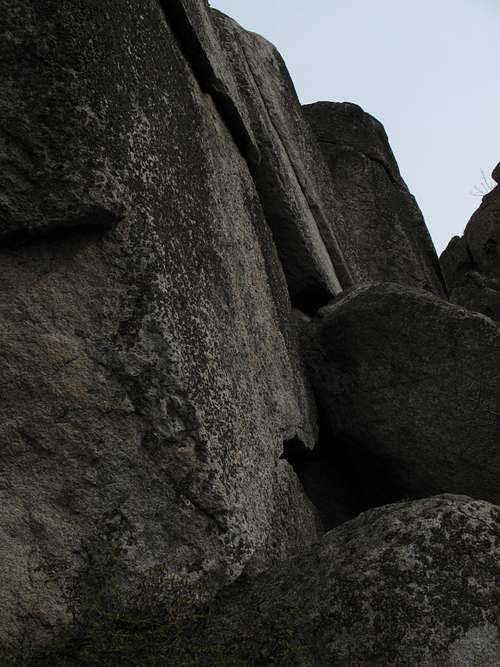
Finding Middle Sunset Wall is not as simple as finding Lower. Horst says a short Class 4 scramble just uphill from Super Sunset Crack takes you to the base of Middle Sunset Wall, but the diagram in his guidebook suggests that the scramble is more than “just” uphill from that route and that it is actually to the right of three more named routes and left of what he calls a “licheny slab.” On rockclimbing.com, the directions say to scramble up a gully on the upper right end of the wall. Both actually seem to be describing the same route, but the gully my friend and I climbed, which was definitely past the last of the bolted routes, involved bushwhacking as well as scrambling. However, icy and wet patches kept us from following what seemed to be the easiest line up.
Personally, I believed the “gully” was a short rock pitch just past the bolted routes but before the real gully that we climbed; this rock pitch, which certainly had a Class 4 look to it, would have led us up into the boulder island that seemed to be Middle Sunset Wall, and from there the described route to the base of Upper Sunset Wall might have been easy to locate. Also, the “short” scramble we had taken was longer than any of the climbs on Lower Sunset Wall, adding to the sense that we did not follow the correct route up.
(After returning two months later, I discovered that the rock pitch mentioned above-- and there is a photograph of it below-- is the correct route up to Middle Sunset.)
To Middle Sunset
After the climb up, the question was not so much whether we had taken the right way up but where Middle Sunset Wall was. From the base of the wall, Upper Sunset Wall was supposed to be clearly visible to the right, and it was, but there was nothing resembling a wall in the immediate vicinity. To the left, though, was a collection of huge granite outcrops forming a veritable island of granite, and they must have been Middle Sunset Wall. Pictures I have studied on rockclimbing.com label as parts of Middle Sunset some rock faces that closely resemble the boulder island we found after climbing up from Lower Sunset. My return visit in March 2009 confirmed that this island-like area of boulders and walls is indeed Middle Sunset Wall.
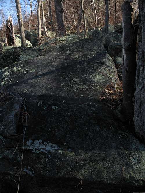
At Middle Sunset, about half the routes face west, but several others are on the north side of the wall. Middle Sunset breaks out of the trees and has better views and more exposure than Lower Sunset does.
Middle Sunset to Upper Sunset
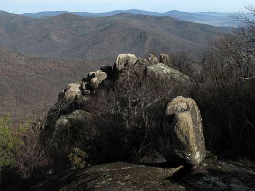
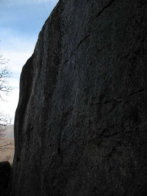
Upper Sunset Wall
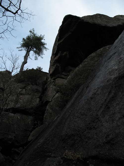
Upper Sunset Wall is clearly visible from atop Lower Sunset Wall and probably has a few reasonable approaches. My sources both mentioned a cave-like opening between some huge blocks near the right end of Middle Sunset Wall, and they both said to hike through the “cave” for about 30’ and find a short Class 4 slot leading through the rocks to reach the base of Upper Sunset Wall.
Instead of seeing and following that route, my partner and I scrambled up an open slab to our right (this, too, could have been the “licheny slab” mentioned in the previous section) and then followed a scrambling/bushwhacking route toward Upper Sunset Wall. Taking pictures, I fell behind, but my partner, after reaching another open area, headed right and very soon afterward stumbled across the Saddle Trail about a five-minute hike from Old Rag’s summit. At the same open area, I drifted left to get some better shots and discovered what resembled the cave-like opening and the slot for which I’d been looking earlier. I have no idea if this was the right spot and suspect, based on my position and guidebook diagrams, that it was not (I believe it was too high and too far west), but I can verify that after exiting the “slot,” heading left would have taken me straight in the direction of Upper Sunset Walls. Instead, I headed right onto a use trail that soon met the Saddle Trail, and my partner and I met on the summit shortly afterward.
During my return visit in March 2009, when I located and followed the correct route to Middle Sunset, I did find a cave-like spot (right and uphill from where the short climb from Lower Sunset meets Middle) and followed it through to the other side of the outcrops. There was a short pitch of Class 4 climbing in the "cave" and extensive, sometimes-exposed Class 3 scrambling on the other side before I reached the forest floor again and could hike the short distance to the base of Upper Sunset. The route through the "cave," though, did not exactly fit the published descriptions, but perhaps I misread the setting or there is another "cave" nearby.
There is an alternate approach to Upper Sunset Wall from the Saddle Trail near the summit area. A few minutes downhill from the summit (or slightly longer from the Byrd's Nest Shelter), look for an obvious use trail. It is not signed but is wide and worn where it meets the main trail. This use trail leads into the Upper Sunset area and is the route by which I emerged from it onto the Saddle Trail.
Most routes on Upper Sunset are north-facing ones.
Please note: The area is relatively compact, an island of rock outcrops and cliffs in a forest sea. Once you reach Lower Sunset Wall, it is almost impossible to get lost!
Upper Sunset
Red Tape
March through November, there is a per-person entry fee of $8; December through February, the fee is $5 (the maximum for family groups is $15 and $10, respectively. Payment is mostly on an honor system, but rangers do collect fees on weekends at Berry Hollow.
No pets allowed. Remember that as much as you love your dog, it is still considered a pet. People routinely violate this restriction; please don't join them.
Be prepared for poison ivy, and be wary of rattlesnakes.
Camping
There are no campgrounds at or near Berry Hollow and Weakley Hollow, but people do sleep in their cars at the trailheads. Backcountry camping is not allowed on Old Rag above 2800'; Lower Sunset Wall is below that level, but there are very few decent places to camp in the vicinity. Free backcountry camping permits are required, and they are obtainable by self-registration at the trailheads.
External Links
Shenandoah National Park Telephone: (540) 999-3500
Official park site