
-
 4238 Hits
-
 84.27% Score
-
 18 Votes
|
|
Mountain/Rock |
|---|---|
|
|
38.55016°N / 78.30762°W |
|
|
Trad Climbing, Toprope, Bouldering, Scrambling |
|
|
Spring, Fall, Winter |
|
|
2455 ft / 748 m |
|
|


Overview
Of all the climbing crags on Old Rag Mountain, this is the hardest to each and the farthest from the trail. Although the trail-to-crag distance is not that great, getting there is definitely an adventure, quite possibly a dirty, bloody, and painful one.
This is one for late winter through early fall. The off-trail approach, with thorns, deadfall, and boulders, is rough enough then, but in summer it becomes like a jungle expedition. Climbers like to refer to the approach as "the approach that nightmares are made of," but it is really not all that bad in the right season.
While there is scrambling here, no one in his right mind is going to put in the effort to get here just to do some scrambling on this small crag. Wall That Dreams Are Made Of is a climbing crag with a handful of routes, including two supposedly stellar ones, and my purpose in making this page is to explain how to find the crag, show what it looks like, and offer photographs of some of the routes-- all things that sites like rockclimbing.com fall short on. I admit to not having climbed a single technical route here, and anyone with climbing experience on the crag is welcome to take this page over if he or she wishes and will commit to developing the route details. For detailed information about the routes, use Eric Horst’s Rock Climbing Virginia, West Virginia, and Maryland, the first chapter of which is devoted to the climbing on Old Rag.
Routes on the Crag
From left to right as you face the crag:
• Bushwhack Face (5.11c)-- Just left of Bushwhack Crack and, as the name implies, a face route. Good for toproping.
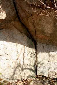
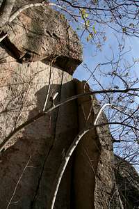
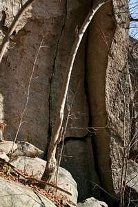
• Bushwhack Crack (5.10c)-- An Old Rag classic. Climb a hand crack and then through a roof up to a ledge. 50'. Shown in two pictures on this page.
• The The (5.13 a/b)-- A thin finger crack a short distance to the right of Bushwhack Crack. 45'. Shown in two pictures on this page. Extra cam units in the .75 to 1.5' range recommended in my guidebook.
• Banana Crack (5.11a)-- An off-width crack and corner just right of The The.
• Swan Song (5.12a)-- Next to Banana Crack. Climb a face and then an arete (past 3 bolts) and then up a thin crack, which is the route's crux. The bolts are easily recognizable, and the bolts and route description were what convinced me that I had found the correct crag, as I was entertaining the thought that perhaps I had not descended enough and was at part of Lower God's Area.
• Potato Chips (5.11d/5.12a)-- Just right of the arete. First climb thin edges and then finish up a dihedral.
Getting There
You can start from Weakley Hollow on the north side of Old Rag or from Berry Hollow on the west. The Berry Hollow approach involves about 3.3 trail miles as opposed to 3.1 via Weakley Hollow, but consider the following: the Weakley Hollow approach involves about 500 more feet of elevation gain than the Berry Hollow approach does, and the Weakley Hollow approach is via the Ridge Trail, a route both scenic and fun but also tiring because of the many Class 3 sections (not hard, but still tiring, especially if you are hauling climbing gear).
Getting to Weakley Hollow
At Sperryville, located along U.S. 211/522 east of Shenandoah National Park and in the park's shadow, turn south onto US 522 where it splits from 211 and turn right onto Virginia 231 shortly afterwards. There is good signage for these intersections. You can also reach 231 via 522 from Culpeper, and you can take 231 all the way from Charlottesville.
A little over 8 miles from Sperryville, watch for the signed turn to Old Rag at Route 602. The road becomes Route 707 at an intersection (stay left on the south side of the river). At the next fork bear left again, now on Route 600. Follow this road for 4 miles to its end at the parking area, which accommodates 200 cars. Park here and walk 0.8 mi to the upper parking area at the end of SR 600. Trails begin here.
Update: As of August 2010, the upper lot is closed to vehicles and parking along the road to it is illegal. This is a permanent closure.
Getting to Berry Hollow
At Sperryville along U.S. 211, look for signs indicating 522 and 231 and follow the directions to them. Turn right on 231. You can also reach 231 via 522 from Culpeper, and you can take 231 all the way from Charlottesville. After about 10 miles along 231, you reach a tiny town called Etlan. Look on the east side of the road for a small convenience store. Directly across the road from the store is SR 643. There should be a sign indicating access to Whiteoak Canyon. Follow this road for about 4 miles until you reach a stop sign. Turn right (a sign for Whiteoak Canyon should confirm this). You are now on SR 600, and it takes you all the way to the signed parking area and trailhead, almost at the very end of the road. Instead of turning into the parking area, continue straight for about 0.8 mi to the end of the road, which is where the Berry Hollow Fire Road begins. It is about 5 miles from the junction of 643 and 600 to the trailhead, and the drive takes about 15-20 minutes.
Finding the Crag-- Trail Approaches
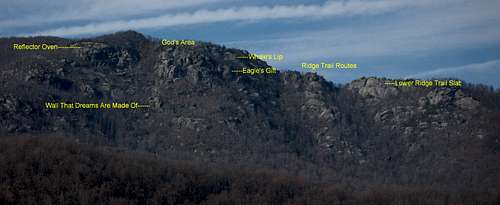
If approaching from Weakley Hollow, hike the Ridge Trail for about 2.2 mi to an open slab studded with a few small boulders and facing east. Just beyond this slab, there is a tree with three trunks on the left side of the trail. About 50 yards past the tree, the trail passes an obvious bowl on the eastern face of the mountain. My guidebook says that a cairn is here, but there was no cairn in January 2009. If you step off the trail, though, you may see a slab with a cairn on it, and that is the start of the bushwhack approach. The slab and cairn are not visible from the trail.
Note: When approaching from Weakley Hollow, it is very easy to mistake the location of and access for this crag. This is because just after the Ridge Trail breaks from heavy tree cover to the rocky upper section of the trail, it passes an open slab facing east and shortly after that passes a tree with three trunks. This is not the spot described in the preceding paragraph. At the slab, you are actually atop what is known as the Lower Ridge Trail Crag, and the prominent cliff ahead of you as you look across the rocky east face of Old Rag is not Reflector Oven. To reach the correct access point, you must continue along the Ridge Trail through some Class 3 sections and through well-known features such as the "cave" and the "staircase."
If approaching from Berry Hollow, hike 2.8 miles to the summit area and continue on. About 5 minutes east from the summit you cross an open area of slabs and boulders; the cliff edge here is the top of Skyline Wall. In about five more minutes, pass the "balanced egg," a huge, obvious boulder that marks the eastern access point for Skyline Wall. Continue about 0.2 mi more to a section where the trail passes an obvious bowl on the eastern face of the mountain. My guidebook says that a cairn is here, but there was no cairn in January 2009. If you pass a tree with three trunks and reach an open slab facing east, you have gone a little too far. (Details and links for those features can be found two paragraphs above.)
Finding the Crag-- From the Trail to the Crag
Start heading down into the bowl and look for a faint unmaintained trail known as the Bushwhack Trail. The Bushwhack Trail is more a concept than it is an actual trail; at times, it is apparent and cairned, but often any trail that may be there is buried beneath leaves, undergrowth, and forest debris. Expect slippery scrambling, deadfall, and thorns; if you are not in pants and long sleeves, expect to bleed.
In any event, you soon pass a spur to Reflector Oven, the crag on your right. The rocks to your left as you head down the Bushwhack Trail are part of the God's Area complex. The trail typically stays very close to God's Area.
Below Reflector Oven, you pass an unnamed, slabby crag on your right. Below that, on the right, is Wall That Dreams Are Made Of.
The distance from the Ridge Trail to the base of Wall That Dreams Are Made Of, according to my GPS device, is 0.72 mi. The elevation loss is approximately 750', from 3205' to 2455'. The trek back up to the trail is, in my opinion, easier than the trip down, where the steepness mixes with slick footing and obstacles to create dangerous conditions, as in great opportunities to lose purchase and break some bones.
Red Tape
March through November, there is a per-person entry fee of $8; December through February, the fee is $5 (the maximum for family groups is $15 and $10, respectively. Payment is mostly on an honor system, but rangers do collect fees on weekends at Berry Hollow.
No pets allowed. Remember that as much as you love your dog, it is still considered a pet. People routinely violate this restriction; please don't join them.
Be prepared for poison ivy, and be wary of rattlesnakes.
Camping
There are no campgrounds at or near Berry Hollow and Weakley Hollow, but people do sleep in their cars at the trailheads. Backcountry camping is not allowed on Old Rag above 2800'. Free backcountry camping permits are required, and they are obtainable by self-registration at the trailheads.
Don't show up the night before and set up a tent at the TH or within sight of it. Rangers look for people doing this, and I have seen people ticketed for it.
Contact Information
Shenandoah National Park Telephone: (540) 999-3500
Official park site