
-
 5856 Hits
-
 83.69% Score
-
 17 Votes
|
|
Mountain/Rock |
|---|---|
|
|
38.55205°N / 78.30677°W |
|
|
Trad Climbing, Sport Climbing, Toprope, Bouldering, Scrambling |
|
|
Spring, Fall, Winter |
|
|
2963 ft / 903 m |
|
|

Jabba the Hut
Overview
Old Rag Mountain has what many regard as the best rock climbing in Virginia, and the east face has some of the best climbing on the mountain, scattered about several named crags. God's Area is a southeast-facing complex of crags and terraces that receive a lot of morning sun and which are therefore great for winter climbing. In fact, this spot can be a miserable place to climb from May through October because of dense undergrowth choking the access routes, especially that to Lower God's Area, and also because the summer heat and humidity there can be stifling.
God's Area has sport, trad, and toprope routes on excellent granite, and although there are a few easy routes, it is mostly a place for moderate and difficult routes. Most of the routes are single-pitch routes, but the area classic Oh My God Dihedral, considered by respected guidebook author Eric Horst to be one of the best routes in the East, can be done as two (more information below).
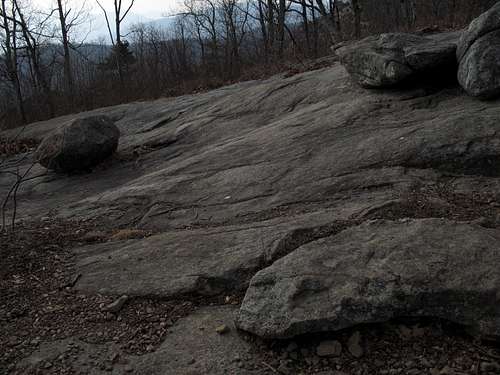
But it's not just for rock climbers. There is plenty of bouldering and scrambling (Class 3 to easy 5) for those equipped with no more than hiking boots and maybe a pair of rock shoes, and the area offers the chance to tour a little-known part of a very popular mountain (see information about Lower God's, the Bushwhack Trail, and Bushwhack Corridor below).
This page will, in addition to providing overview information, describe how to find the crags and will photographically represent some of its routes and other features. Because there are so many routes scattered about three principal areas (more than 20 in all, and around a quarter of all the established routes on Old Rag), this page will not even attempt to cover them all. For more information about the routes, use Eric Horst’s Rock Climbing Virginia, West Virginia, and Maryland, the first chapter of which is devoted to the climbing on Old Rag, or visit the rockclimbing.com page for God's Area. If anyone who has extensive experience climbing here would like to take this page over or make additions concerning routes, please send me a PM.

Getting There
You can start from Weakley Hollow on the north side of Old Rag or from Berry Hollow on the west. The Berry Hollow approach involves about 3.3 trail miles as opposed to 3.1 via Weakley Hollow, but consider this: the Weakley Hollow approach involves about 500 more feet of elevation gain than the Berry Hollow approach does, and the Weakley Hollow approach is via the Ridge Trail, a route both scenic and fun but also tiring because of the many Class 3 sections (not hard, but still tiring, especially if you are hauling climbing gear).
Getting to Berry Hollow
At Sperryville along U.S. 211, look for signs indicating 522 and 231 and follow the directions to them. Turn right on 231. You can also reach 231 via 522 from Culpeper, and you can take 231 all the way from Charlottesville. After about 10 miles along 231, you reach a tiny town called Etlan. Look on the east side of the road for a small convenience store. Directly across the road from the store is SR 643. There should be a sign indicating access to Whiteoak Canyon. Follow this road for about 4 miles until you reach a stop sign. Turn right (a sign for Whiteoak Canyon should confirm this). You are now on SR 600, and it takes you all the way to the signed parking area and trailhead, almost at the very end of the road. Instead of turning into the parking area, continue straight for about 0.8 mi to the end of the road, which is where the Berry Hollow Fire Road begins. It is about 5 miles from the junction of 643 and 600 to the trailhead, and the drive takes about 15-20 minutes.
Getting to Weakley Hollow
At Sperryville, located along U.S. 211/522 east of Shenandoah National Park and in the park's shadow, turn south onto US 522 where it splits from 211 and turn right onto Virginia 231 shortly afterwards. There is good signage for these intersections. You can also reach 231 via 522 from Culpeper, and you can take 231 all the way from Charlottesville.
A little over 8 miles from Sperryville, watch for the signed turn to Old Rag at Route 602. The road becomes Route 707 at an intersection (stay left on the south side of the river). At the next fork bear left again, now on Route 600. Follow this road for 4 miles to its end at the parking area, which accommodates 200 cars. Park here and walk 0.8 mi to the upper parking area at the end of SR 600. Trails begin here.
Update: As of August 2010, the upper lot is closed to vehicles and parking along the road to it is illegal. This is a permanent closure.
Finding the Crags
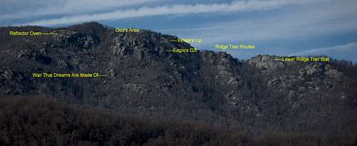
The East Face of Old Rag, with labels
Important for locating the crags...
Useful for locating the crags...
This section covers how to find the crags and what you will find at them. The descriptions are based on starting from Berry Hollow as opposed to Weakley Hollow since starting from Berry Hollow makes more sense.
This page has photos and links to others that help identify major landmarks that will assist you in accessing the crags.
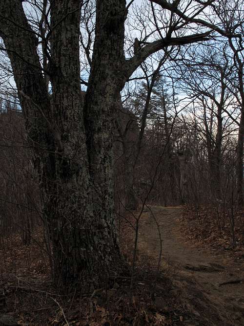
Upper God's Area-- Hike 2.8 miles to the summit area and continue on. About 5 minutes east from the summit you cross an open area of slabs and boulders; the cliff edge here is the top of Skyline Wall. In about five more minutes, pass the "balanced egg," a huge, obvious boulder that marks the eastern access point for Skyline Wall. Continue about 0.2 mi more to a section where the trail passes an obvious bowl on the eastern face of the mountain. My guidebook says that a cairn is here, but there was no cairn in January 2009. Just beyond this spot is a tree with three trunks, just beyond which is an open slab facing east. If you reach a larger open slab that drops off precipitously and which has a lone pine tree growing on it near its northern end, you are actually atop Whale's Lip, another Old Rag crag, and have gone a little too far.
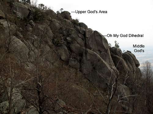
Walk down the gently sloping slab (the one just past the tree with three trunks) and look for a faint trail heading into the woods. Almost immediately, the "trail" splits. Head right and slightly downhill to reach Upper God's; you can also scramble down and right to reach the top of Oh My God Dihedral or continue along some slabs (sloping and mossy in places, and no place for a slip) to a crag called Jabba the Hut.
There are a few established routes at Upper God's, but most routes at God's Area are in the middle and lower sections.
Upper God's Area is great for hikers and scramblers to visit because the approach is relatively painless, there is a lot of fun scrambling, and there are exceptional views.

Upper God's Area
Middle God's Area-- Between Oh My God Dihedral and Upper God's, look for a Class 4 gully to take you down to Middle God's. The only ways down I have found thus far seemed harder than Class 4, but I was there in snow/ice conditions. The gully that seems to be the correct one is beside the outcrop labeled on this page as Middle God's. Keep in mind that you can always rap down to the base of Middle God's if you have trouble finding good scrambling access or don't want to look for it.
You can also reach Middle God's from below via the Bushwhack Trail and Bushwhack Corridor (see Lower God's below), but it is not easy to find the right way up and through Lower God's to reach Middle God's. It is better to approach from above and scramble or rap to the base of the crag.

Middle God's Area
Oh My God Dihedral-- This lieback granite route starts with a 15' 5.5 crack and then becomes 5.10c. It is about 100' long but can be longer if one starts below from what is called the Patio Ledge.
To reach it, follow the directions below for Lower God's. Keeping your eye on the route, make your way over to its base. To reach Patio Ledge, keep descending on the Bushwhack Trail until you reach the rock outcrops directly below Oh My God Dihedral.

Oh My God Dihedral...

Lower God's Area-- Hike 2.8 miles to the summit area and continue on. About 5 minutes east from the summit you cross an open area of slabs and boulders; the cliff edge here is the top of Skyline Wall. In about five more minutes, pass the "balanced egg," a huge, obvious boulder that marks the eastern access point for Skyline Wall. Continue about 0.2 mi more to a section where the trail passes an obvious bowl on the eastern face of the mountain. My guidebook says that a cairn is here, but there was no cairn in January 2009. If you pass a tree with three trunks and reach an open slab facing east, you have gone a little too far.
Start heading down into the bowl and look for a faint unmaintained trail known as the Bushwhack Trail. The Bushwhack Trail is more a concept than it is an actual trail; at times, it is apparent, but often any trail that may be there is buried beneath leaves, undergrowth, and forest debris. In any event, the crags of God's Area are easy to see on your left; Reflector Oven is to the right.
The routes on Lower God's are accessed by hiking down to the base of the rocks and turning left beneath them. This takes you to an area known as Bushwhack Corridor, again more a concept than an actual trail. You can use Bushwhack Corridor to access Middle God's by hiking past the last of its routes and then looking for a narrow passage between rocks that will take you up and back in the other direction to reach the rocks, where there is also a Class 4 access to Upper God's. You can also follow Bushwhack Corridor a short distance east and up to Eagle's Gift, from which you can reach Whale's Lip and then the Ridge Trail again for an interesting off-trail adventure involving bushwhacking and scrambling and solitude on a mountain that often offers little of it (solitude).
Red Tape
March through November, there is a per-person entry fee of $8; December through February, the fee is $5 (the maximum for family groups is $15 and $10, respectively. Payment is mostly on an honor system, but rangers do collect fees on weekends at Berry Hollow.
No pets allowed. Remember that as much as you love your dog, it is still considered a pet. People routinely violate this restriction; please don't join them.
Be prepared for poison ivy, and be wary of rattlesnakes.
Camping
There are no campgrounds at or near Berry Hollow and Weakley Hollow, but people do sleep in their cars at the trailheads. Backcountry camping is not allowed on Old Rag above 2800'. Free backcountry camping permits are required, and they are obtainable by self-registration at the trailheads.
Don't show up the night before and set up a tent at the TH or within sight of it. Rangers look for people doing this, and I have seen people ticketed for it.
Contact Information
Shenandoah National Park Telephone: (540) 999-3500
Official park site