
-
 108993 Hits
-
 95.51% Score
-
 53 Votes
|
|
Area/Range |
|---|---|
|
|
46.33632°N / 114.30898°W |
|
|
Hiking, Mountaineering, Trad Climbing, Sport Climbing, Toprope, Bouldering, Aid Climbing, Big Wall, Mixed, Scrambling, Skiing |
|
|
Spring, Summer, Fall, Winter |
|
|
Overview
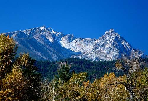
The Bitterroot Mountains, a portion of the Rocky Mountains, are probably the best known peaks of the Bitterroot Range. This range is classified as Montana’s largest; whether "largest" means it's the longest or covers the most area, I don't know. The range runs along most of the border between Montana Idaho.
Note: There is plenty of confusion when people refer to the Bitterroot Mountains, even among the locals. In fact, there is a point-of-interest sign along HWY 93 which misleadingly refers to the "Bitterroot Mountains" as the "Bitterroot Range" (Correct? Yes, but misleading nonetheless). In truth, the Bitterroot Range includes mountain ranges along the Montana-Idaho border from Cabinet Gorge on the north end to Red Rock Pass at the south end. The included ranges are (north to south) The Bitterroot Mountains, The Beaverhead Mountains, and the Centennial Mountains.

The most rugged peaks in the Bitterroots, between Lolo and Lost Trail Passes, are often referred to as the Montana Alps; their glacier-swept horns, ridges, and high cirques attract many climbers to the windswept granite peaks, despite approaches up to 20 miles in length.
In 1805, Lewis & Clark and the Corps of Discovery traveled along the Lost Trail through the Bitterroot Mountains during their journey to the Pacific Coast. Cold and hungry, they descended into the valley of the Salish Nation where they encountered 440 Native Americans in an area now known as Ross' Hole.
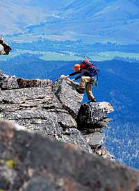
These mountains, with long arduous approaches to major peaks, are some of the most impenetrable in the United States; except for areas of the foothills, the Selway-Bitterroot Wilderness remains mostly unexploited.
In southwest Montana, the Bitterroots are extremely popular to those seeking recreation. From one-pitch trad, sport, and toprope climbs in Kootenai Canyon, bouldering near Lost Horse, multi-pitch big wall aid climbs in Blodgett and Mill Creek Canyons, plus mountaineering and hiking on the high peaks, the "root" provides unlimited opportunities. One could spend a lifetime on the peaks between the Lolo and Lost Trail Passes and never run out of new and interesting things to see and do.
A Bitterroot Legend – The Lost Bonanza

After spending most of the summer of 1922 prospecting on Camp Creek (up the north fork of the Salmon River) Arthur Woods was making his way back to Darby, Montana. Maude, his old white mare, and Arthur were hurrying to reach Pierce Creek on the Lost Trail Divide. The snow would be flying soon, and he figured he had a couple more weeks of prospecting before his grubstake ran out.
Just south of Lost Trail, Woods noticed some wash gravel in the roots of an uprooted tree. Reigning Maude to a stop, he paused just long enough to scoop some of the gravel into a sack then continued a short distance before setting up camp for the night. The next morning, before breaking camp, he panned the gravel and was mighty surprised to find almost an ounce of gold.
Woods worked the area for several weeks, until the snow and lack of provisions forced him to end his season and go to Darby. The next summer (June 17, 1923) he returned. Because he’d not filed a claim, he was careful to keep out of sight of any passing packers, and worked the area in secret.
In September 1923, Arthur covered all evidence of his mine and camp and returned to Darby. Dragging his saddlebags filled with about 70 pounds of gold dust into the residence of Bill Ward, Darby’s Sheriff, he said, "I haven’t scratched the surface. Come spring, I’ll take you to the area."
Leaving his beloved Maude with the Wards, Arthur went to Butte to spend the winter with his sister.
It wasn’t until 1925 that Wood's sister arrived in Darby to tell the Wards of her brother’s death. Wanting part of the mine, she and the Wards searched for years but could not find the spot. The Ward’s grandson continued the search into the 1960s but never did discover the location of the missing gold bonanza.
I first learned of this legend from the book, Bitterroot Memories by Ada M. Powell
If you found this legend interesting, you may enjoy Buster's Bonanza, a work of fiction based on these historical facts.
Selway-Bitterroot Wilderness/ Bitterroot National Forest

At over 1.3 million acres the Selway-Bitterroot is the third largest Wilderness in the Lower 48. California's Death Valley Wilderness and Idaho's Frank Church-River of No Return Wilderness are the only Wilderness areas which are larger. Less than one-fifth of the area lies in Montana - approximately 250,000 acres.
The 600-foot-wide Nez Perce Trail, an unimproved dirt road, separates the Selway-Bitterroot from the Frank Church-River of No Return. This Wilderness area runs both sides of the Bitterroot Range, standing along the Montana-Idaho border.
This vast wild land is one of the roughest mountainous areas in the developed world. It is a country filled with barren peaks rising high above the dense patches of forest below.
Few humans visit the huge unspoiled portions of this Wilderness which makes it all the more appealing for climbers. Many miles of trails, a great number of which are rugged and seldom maintained, provide access to the Montana side of the Selway-Bitterroot.
 |
|---|
The Divide Trail (Trail 16) follows the Bitterroot Divide for approximately seven miles north of Nez Perce Pass, offering outstanding views across the Montana and Idaho portions of
the Wilderness.
The Bitterroot National Forest spans 1.6 million acres. The elevation in the forest varies from 3,200 feet in the valleys to 10,157 feet at the summit of Trapper Peak. There are two major rivers in the forest, the Selway and the Salmon, which drop in elevation to just over 2,000 feet.
For more information, check:
Wilderness.net's information on the Selway-Bitterroot Wilderness
The Forest Service's Site for the Bitterroot National Forest
Magruder Road Corridor

The 101-mile primitive Magruder Corridor Road winds through a vast undeveloped area, offering solitude, pristine beauty, and expansive mountain views. The landscape is still much the same as when the Nez Perce Indians and other early travelers passed through.
The road has changed little since its construction by the Civilian Conservation Corps (CCC) during the 1930s. It has been known be several names, such as The Southern Nez Perce Trail, The Elk City to Darby Road, The Montana Road, and The Parker Trail.
The corridor was created in 1980 when the Central Idaho Wilderness Act was passed, leaving a unique road that enables a traveler to drive through and between two wildernesses: the 1.2- million-acre Selway-Bitterroot Wilderness to the north, and the 2.3-million-acre Frank Church-River of No Return Wilderness to the south.
Together, these two Wildernesses represent the largest unroaded block of land in the lower 48 states and are cover nearly twice as much land as the combined states of Delaware and Rhode Island.
This primitive one-lane road is rough, steep, and winding with few turnouts for dealing with oncoming vehicles. It is suitable for high-clearance vehicles, pickup trucks, motorcycles and mountain bikes.
Travel time varies, but it takes eight to ten hours to travel from Red River to Darby without rest stops at an average speed of 12-15 miles per hour.
Geology

The Bitterroot Valley is a basin about 65 miles long from north to south and as much as 10 miles wide. On the west side, the bold and craggy Bitterroot Mountains rise abruptly as a remarkably even face, cut by deep parallel U-shaped canyons which were carved by glaciers. To the east are foothills that gradually lead up to the far more subsided Sapphire Mountains. These mountains are distinctly different from the Bitterroots on the west of tha valley, but interestingly enough, are intricately connected in their origin.
The Bitterroot Mountains are part of the Idaho Batholith, enormous masses of granitic rock which stretch almost unbroken along the western border of Idaho. This expanse of granitic rock cooled from a large number of smaller masses of molten rock that rose one-by-one into the earth's crust about 200 million years ago. Emplacement of all those masses of granite which make up the Idaho batholith must have bulged the earth's surface upward, creating a high area. Evidently, a large porion from the top of this bulge slid off, moving over time about 50 miles east to there current location and are known as the Sappphires.
As the Sapphire block moved eastward, the Earth's crust floated upward in central Idaho, raising the rocks that had been under it to approximately their current elevation. Meanwhile, the earth's crust in Montana sank beneath the load of the great slab of rock as it moved in from Idaho. So, we now have two mountainous areas instead of one, neither as high as the original would have been had the Sapphire block not moved.
The Bitterroot Valley lies between the extremely slabby gneiss which forms the front of the Bitterroot mountains (on which the Sapphire block slid), and the Sapphires. The valley filled with sediment during past dry climate episodes that followed the intrusion of the granitic rocks.
Soil erodes rapidly in dry regions because plant cover is too sparse to shelter the ground and streams are too shortlived to carry the eroded soil. Thus, the valleys of western Montana filled. We currently live in a comparatively wet, post-glacial period that allows the streams to slowly carve through the valley basin fill.

Summit Lists
Bitterroot Mountain peaks with summits over 9,000'
Bitterroot Mountain peaks with summits between 8,500' and 8,999'
 |
|---|
Weather & Avalanche Conditions
Western Montana Avalanche Center Avalanche Advisories (December through March)
National Weather Service - Extensive weather maps and climatic data.
Automated surface observation station index map
Bitterroot Snotel Sites
Saddle Mountain - 7,900', near Lost Trail Pass
Nez Perce Camp - 5,650', west of Darby
Twin Lakes - 6,400', near Lost Horse
Twelvemile Creek - 5,600', Back Lost Horse Canyon, MT
Lolo Pass - 5,240', HWY 12 west of Lolo, MT
Weather Conditions
School Point - 5,800', Along route to Boulder Point, MT
Little Rock Creek - 5,507', Above and south of Lake Como, MT