Intro/Stats/Notes
Capitol Ditch trail
Campsites 2-4 at Capitol Lake
Day 1 - backpack in (4 hrs)
Day 2 - summit day (9 hrs)
Day 3 - backpack out (3.25 hrs)
Although the descriptions specify 4WD, we saw a Cooper Mini at the trailhead.
There are only 8 sites near the lake. All are below the lake and many are shady. Campfires are not allowed in this area. There is a sign a short distance below the camping area that specifies these rules. If you want a campfire, you can camp in the woods below the sign.
The trip
![Capitol parking lot]() At the trailhead
At the trailheadWe arrived at the trailhead shortly after noon on Friday. The road was damp and it was obvious that it had rained recently. As we headed up the trail, our first glimpse of our target was shrouded in clouds, and a gray mist hung over the valley in the distance. The hike up to the lake started out too easy, but we paid the price later when the trail rose steadily at the end. A little after 2 pm we encountered a group who said they had started at 8 am and had already summited. We determined later that they must have summited the lake.
Route finding was obvious, and there was no need for wading or water shoes as we found stones or tree trunks across all the water crossings. Other than the dead rotting cow near one of our rest stops, the hike up was very pleasant.
We selected campsites 2-4 which contained some nice flat and shady spots and set up camp. The clouds lifted and the sky started to clear so we began to feel optimistic about the next day.
On summit day we left the campsite at 5:15 a.m. Within an hour we were at the saddle between Daly and Capitol watching the sun rise.
![Sunrise]() Sunrise
Sunrise
We followed the trail south into the basin between Mt Daly and Clark Peak, donning our helmets as we crossed some steep, rock-filled gullies. When we reached the valley between Clark Peak and K2 we turned right just to the north of a large snowfield and headed up towards K2. At K2, part of our group climbed to the top (easy climb from the east) and others skirted it on a path to the north. The west descent from the top of K2 back to the trail was quite tricky!
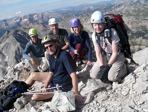
A few more steps, then on to the knife edge. The weather was holding out with only a few small clouds in the distance so we continued on. We used a combination of straddles and hand holds, then re-grouped and breathed a sigh of relief. After ascending the .1 mile per directions, we traversed below the northeast ridge. There were cairns and trails at different levels. We followed one of these trails southeast for a while, then made our way up the class 4 scramble until we reached the trail that winds around the south side of the peak. We reached the top at about 9:45 am, 4.5 hours after leaving the campsite.
![The group on Capitol]() On top of Capitol
On top of Capitol![Capitol lake from summit]() Capitol Lake from the summit
Capitol Lake from the summit
For the descent, we took a trail slightly to the south of the area that we had climbed up. This was easier than downclimbing our ascent route.
If you have already lost interest in this trip report, you will never know the reason for its title. However, if you had the fortitude to make it this far, here it is.
![On the knife edge]() On the knife edge
On the knife edge
On the way back, as we were straddling or grasping the knife edge, a person was observed traversing the entire length of the knife edge on a route just below and to the south of it. This person not only completed the traverse more quickly than us knife-huggers, but commented that it felt much safer down there. So, the truth is . . . YOU DO NOT NEED TO CROSS THE KNIFE EDGE TO SUMMIT CAPITOL!
![Knife edge hoax]() Evidence of the hoax
Evidence of the hoax
After the knife edge, we took a quick break and removed our helmets to cool off. The helmets went back on quickly after a rock loosened by a marmot came hurtling down the hill towards us. It was a gorgeous day and we took our time descending and capturing the valley's beauty.
![Wildflowers]() Wildflowers
Wildflowers
We cleaned up in the lake or stream, ate an early dinner, then spent 12 hours in our tents after the sky opened up in the evening.
The next day the peak was again enveloped in clouds all day as we descended. We moved steadily downhill, at one point driving a small herd of cows down the trail until an encounter with a horse group. After a brief stand-off, the riders dismounted to control their horses and we passed through behind the cows.
Of the 3 days in the area, we felt lucky to have picked the best day. The celebration took place at a small Glenwood micro-brewery, followed by a ride home in the rain and mist.


Comments
Post a Comment