How It All Started
“Do you think we can jump across?”
“Yeah, it looks easy.” I replied.
I jumped the gap and looked back at my climbing partner, patiently waiting for him to do the same. His face knotted up in concentration, my friend Timmy transitioned to a slight crouching position, and with a big arm swing lunged across.
Only he didn’t quite make it.
At the time I thought this meant he would most certainly die. Fortunately, I was on my neighbor’s roof instead of on a mountain, and my first grade friend and I were simply jumping from one part of the roof to another. Unfortunately, the part of the roof we were jumping over was made of a flimsy plastic material surrounded by more solid shingles, and upon coming up short, Timmy fell straight through, landing with a crash over ten feet below. We knew we shouldn’t have been up there (the side of the neighbor’s roof visible from our fence sloped down at one point to just two feet above the ground, which was just too tempting for a couple of curious six year olds, though), so when I immediately heard the maid below start screaming in Swahili (our families were living in Pretoria at the time, and we both attended an international school just outside of Johannesburg), I high-tailed it back across the roof the same way we had come. As the yelling got louder, to my relief Timmy suddenly darted out of a side entrance, and joined me as we ran up the driveway. I yanked him into a dense bamboo thicket between the front yards of my house and the neighbor’s house, and the maid, just a few seconds behind him but not sure where we had gone, took off down the sidewalk, still yelling in words we couldn’t understand but sounding very angry.
Despite somehow not breaking anything, Timmy’s body was still covered in bruises, and this evidence combined with a little visit by the neighbor couldn’t prevent the truth from getting out. After splitting the cost of the roof, our parents subsequently grounded both of us.
So began my climbing career. Timmy was actually the one who instigated it, but until first grade I think my desire to climb things had just been lying dormant. Whenever I went over to play at his house, in between Nintendo games he would often propose climbing on the high brick/stone walls separating the nearby houses as a way to pass the time. It was great fun, and within a few tries we were quite good at tight-roping our way along the walls between houses, unafraid of the inherent risk of falling, or the less obvious signs of vicious guard dogs just waiting to dash from their hiding places to tear us apart should we stray into their territory. Usually the walls were only about 6 to 8 feet high, but in some places they rose between 10 and 12 feet above the ground (i.e. the U.S. Marine house, where the U.S. Embassy adult employees would usually socialize and party, while the kids ran around in the big yard outside). It’s not that my parents didn’t do their best to ensure I was being safe, but I just had a penchant for dashing off and climbing things as soon as their eyes were off me.
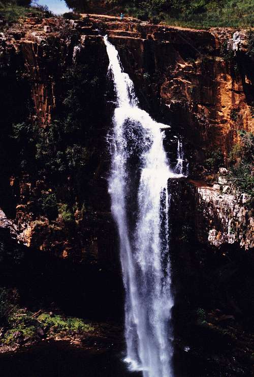
Here’s a picture of me at Berlin Falls in Mpumalanga, South Africa (I’m the little speck of bright blue clothes at the top). While my parents were distracted with my two younger brothers and taking just a couple minutes to unload the trunk to set up for a picnic, I snuck off and ran a few hundred yards around the gorge between the dirt parking lot and the waterfall (just out of the picture, to the right) to get a closer look. I was then eight at the time, and must have imagined I was on an Indiana Jones adventure:
![Berlin Falls]() Me at the top of Berlin Falls in Mpumalanga, South Africa
Me at the top of Berlin Falls in Mpumalanga, South Africa
My Mom, who feared this might have been the last time she saw me, took the picture. Upon arriving back at the car, I received a big spank followed by a tearful hug, and a big talking-to about why I needed to be more careful and shouldn’t have run off like that.
From that point on I’d like to think I got much better at assessing risk and erring on the side of caution, but the seed of adventuring and climbing had been planted.
Gaining Experience
Years later, I climbed Longs Peak, and despite getting caught in a lightning storm on the way down, I caught the mountain hiking/climbing bug as a result. I purchased Roach’s 14er guidebook, at which point I began looking for more challenging scrambles. Capitol Peak was the one that stood out to me more than any other, and upon discovering Summitpost and seeing pictures of the Knife Edge, my first thought wasn’t “That looks scary!”, but rather “That looks fun!”
At 23, I was in the best shape of my life, and my summer training regimen of jogging at least two miles every day had allowed me to basically jog up Elbert, Longs, and then Holy Cross without any difficulty. I had contemplated trying Capitol with some other interns I was staying with in Boulder before heading back to Utah, but eventually we ran out of free weekends to try it. It was for the best though, because at the time I was still very inexperienced when it came to route-finding and scrambling on exposed ridges.
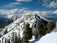
![Nebo north ridge trail]() Mount Nebo Mount Nebo | ![West Slopes]() Cascade Mountain Cascade Mountain | ![Monte Cristo from Superior]() Mount Superior Mount Superior | ![Pfeifferhorn east face]() Pfeifferhorn Pfeifferhorn |
|---|
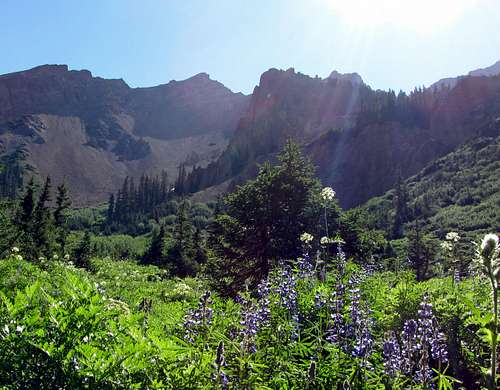
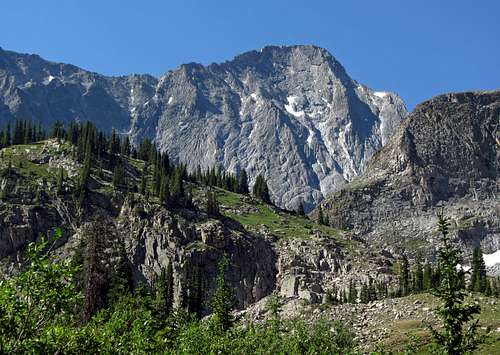
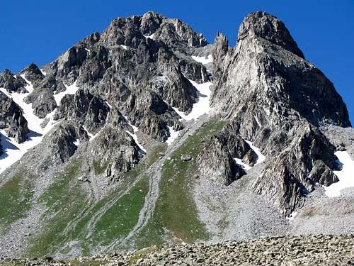
Since then I got married and we now have a son and a daughter. This helped me keep things in perspective as I continued to do harder ridge scrambles, and I have definitely become more cautious when it comes to climbing mountains. The itch was still there though, so to ensure that I didn’t jump into anything I wasn’t prepared for, I started out with easier ridge hikes and scrambles. It was a far-off goal of mine to do something exciting like the Knife Edge sometime, but the jump from class 3 to class 4 seemed like a big one. In preparation for the big step up, over the course of several summers I did some easier ridge scrambles. Among them were Mount Nebo (class 2+ north ridge), Cascade Mountain (class 3 south ridge), Mount Superior (class 3 east ridge), Pfeifferhorn (class 3 east ridge), Devils Castle (class 3+ west ridge), Angels Landing (class 2+ west ridge), Lone Peak (class 3+ north ridge), Mount Sneffels (class 3 southwest ridge), and Sundial Peak (class 3 south ridge). Eventually I became more and more comfortable with exposed ridge scrambling, and at this point I knew I was finally ready to make the jump.
![Dead Bush/Tree below West Summit]() Devil’s Castle Devil’s Castle | ![Angels Landing cliff]() Angel’s Landing Angel’s Landing | ![Lone Peak summit ridge]() Lone Peak Lone Peak | ![Mount Sneffels summit]() Mount Sneffels Mount Sneffels | ![Sundial summit ridge]() Sundial Peak Sundial Peak |
|---|
Knowing When to Turn Back
This last year I was more busy with work and school than ever (besides a brief respite over the Christmas/New Year holidays, I was spending up to 80 hours a week at a computer doing firmware and software design, for almost 8 straight months), and that combined with other responsibilities contributed towards an over-consumption of soda and sugar to give me enough energy to do everything I needed to. As a result, I put on over fifteen pounds and became completely flabby and out of shape. With the opportunity suddenly coming up for me to try Capitol Peak on the way out to Denver to see my wife’s family though, and realizing that having just turned 30 it would not get any easier to stay in shape as time went on, I tried my best to bounce back. In a couple months I had cut back on the soda and exercised enough to lose ten pounds and drop back down below 200, and near the end of June I was able to jog up to three consecutive miles during lunch breaks. A little concerning, though, was the fact that the jogging started giving me some sharp pains near the bottom/back of my foot (doctor said it was most likely plantar fasciitis, or maybe given my medical history, a non-threatening blood clot). Also, I did not have time to do any acclimatization hikes beforehand, so the last time I had hiked above 7,000 feet had been over nine months before. Usually, I ramp up on easier hikes throughout the summer and leave the harder ones until last for when I’m in better shape, but I wouldn’t have that luxury this time. With family responsibilities it’s not always easy to find time for hiking/climbing, so I had to take advantage of the opportunity the best I could.
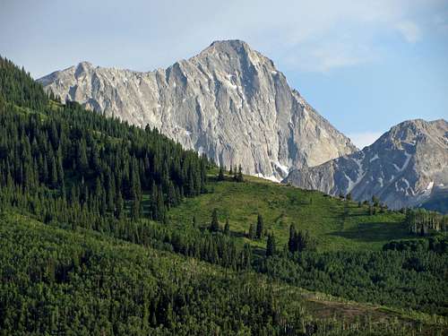
![Capitol Peak from trailhead]() Looking south from near the Capitol Creek Trailhead we could see Mount Daly (left), Capitol Peak (middle), and an un-named peak (right)
Looking south from near the Capitol Creek Trailhead we could see Mount Daly (left), Capitol Peak (middle), and an un-named peak (right)![Capitol Creek aspen grove]() Aspen grove
Aspen grove![Green & red scenery]() Aspens, evergreens, & red rock
Aspens, evergreens, & red rock
Due to the extremely dry spring conditions, most of the standard route on Capitol Peak was snow-free (except for the bowl below the Mount Daly / K2 saddle), meaning we could climb it without ice axes or crampons almost two months earlier than in a typical snow year. I had scoured dozens of trip reports on 14ers.com, and from the pictures I knew that the Knife Edge wouldn’t be a problem for me, but the weather and my lack of conditioning might. The plan was to drive to Carbondale from Salt Lake City on Thursday, hike Capitol Peak on Friday, and then meet up with the wife’s family in Denver on Saturday. It took some convincing, but my hiking partners agreed on an early start.
![Capitol Peak over meadows]() Beautiful granite walls over green meadows
Beautiful granite walls over green meadows
My family and I made it across I-70 just in time to pass by a big fire that had started up earlier on Thursday between Grand Junction (the inside of our car had a layer of ash on everything after driving through the smoke, though), but my friends were not so lucky. Kendrick, James, and Serena left work in Salt Lake a bit later, and with the fire jumping the freeway and closing it, they were forced to take a long detour through some mountain roads southwest of Carbondale. As a result, they didn’t get into their campsite until after midnight.
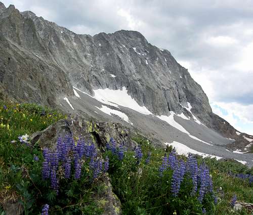
![Rugged mountains over purple wildflowers]() The wildflowers were out early this year
The wildflowers were out early this year![Red Mountain over Capitol Creek]() Red mountain
Red mountain
Despite lying down to sleep at around 10 pm that night, I was so nervous and excited that I only got a couple hours of sleep. I had wanted to start extra early (3 am) to optimize our chances of success, but due to the fire and late arrival, my friends weren’t able to swing by the Comfort Inn hotel in Carbondale on the way to the Capitol Creek Trailhead until much later. We didn’t leave Carbondale until 6:30 (just right before I would have called off the whole thing because of how late it was), and finally set off from the trailhead at 7:30.
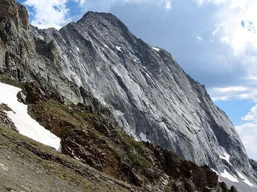
![Capitol Peak from below Capitol Lake]() North Face
North Face![Rugged Peak southwest of Capitol Creek Trail]() Impressive un-named peak north of Capitol Peak
Impressive un-named peak north of Capitol Peak![Capitol Peak meadow]() Trail to Capitol Lake
Trail to Capitol Lake![Un-named Peak west of Capitol Creek Trail]() Un-named peak west of Capitol Creek Trail
Un-named peak west of Capitol Creek Trail
From the very start of the trail, Capitol Peak’s impressive north face is visible to the south, and stays in view for much of the hike towards Capitol Lake. The trail is very gradual at first, so I felt like I was doing fine, but about a mile in I started getting that sharp pain in the back of my right foot again. I must have changed the way I was walking as a result, because just about a mile later I could feel a blister forming on the heel of that foot. While these were a relatively new pair of boots (my feet somehow had grown a half size over the last few years, requiring new ones), I had done several short hikes and worn them to the office and up and down whatever stairs I could find the past year, and until then I thought I had broken them in. To nip the problem in the bud sooner rather than later, we stopped for a few minutes after the stream crossing for me to patch up my foot a bit.
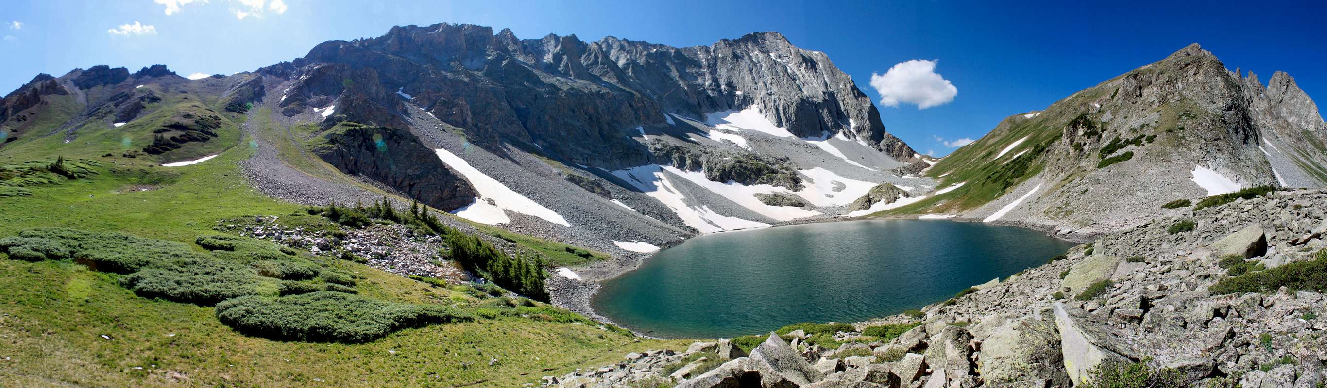
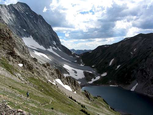
![]()
Capitol Lake panorama (with the trail up to the Mt. Daly saddle on the left)
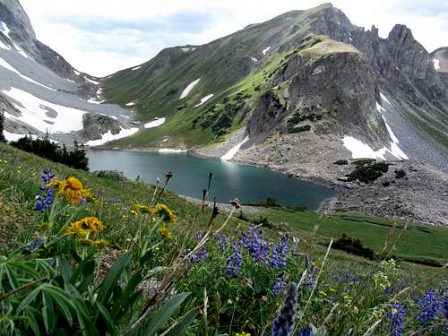
![Capitol Lake wildflowers]() Capitol Lake wildflowers
Capitol Lake wildflowers![Barefoot at Capitol Lake]() Break at the lake
Break at the lake
I had been pleasantly surprised by the scenery up until this point (the lush green vegetation and large groves of aspen trees all along the Capitol Creek Ditch Trail contrasted nicely with the reddish soil on the trail that is prevalent in many parts of the Snowmass Wilderness Area), and with the sun raising the temperature slightly, it was a pleasant change of surroundings when we then entered a more densely forested area.
![Capitol Peak over wildflowers]() Wildflowers below the northeast ridge of Capitol Peak
Wildflowers below the northeast ridge of Capitol Peak![Capitol Lake wildflowers]() Capitol Lake wildflowers
Capitol Lake wildflowers![Peak north of Capitol Lake]() Peak over Capitol Lake
Peak over Capitol Lake![Steep trail above Capitol Lake]() Steep trail to Daly saddle
Steep trail to Daly saddle
The conditions were perfect, but on the steeper portions of the hike I could already feel myself getting out of breath. I suppose it wasn’t entirely unexpected since even the trailhead was at a higher elevation than anywhere I’d been in the last nine months, but I was hoping that the previous month’s exercise would have done more to combat this. James, Serena, and Kendrick were booking it up the mountain without any problems whatsoever, so I felt a bit stupid knowing that I was the one slowing everyone down when this whole hike had been my idea. In my defense, they are all fitness machines, with more free time than me. Kendrick does a lot of biking (did the Kokopelli Trail from Moab to Fruita in just three days earlier that spring), Serena had done the Grand Teton in a single day and had already done several climbs that spring (including Borah Peak in Idaho), and James was even faster than them. Serena said that James looked tired on their Grand Canyon rim-to-rim hike, but I don’t know if I believe it, since the few times I’ve hiked with him he has displayed cyborg-like qualities and never appears out of breath.
![View northwest from Daly saddle]() Looking back to the north from the saddle below Mt. Daly
Looking back to the north from the saddle below Mt. Daly
Eventually the pine trees gave way to more open views of Capitol Peak and its imposing northeast ridge as we got closer to Capitol Lake. Off to the west were impressive views of an un-named peak as well. Included in the awesome surroundings were several wildflowers, mostly of the purple variety. Despite my shortness of breath, I enjoyed soaking in the scenery. Upon arriving at the lake we took our second break, and I took off both of my boots to patch up some heel blisters which were now on both feet. The skin had chafed to the point where a nice little sack of fluid was now hanging off the back of each heel, and I knew it was only a matter of time before they burst. Serena lent me some medical tape, and in combination with my special giant blister band-aids, I wrapped them up the best I could. The others snacked and goofed around during our long half hour break, and a marmot popped out between some of the rocks to hang out with us for a bit as well.
![End of the trail]() The last part of the trail, after which we had to cross through large boulder fields and some snow
The last part of the trail, after which we had to cross through large boulder fields and some snow![Gully below Daly saddle]() Gully below Daly saddle
Gully below Daly saddle
Ascending from the lake to the saddle below Mount Daly is when the altitude really hit me. Up until this point I had just been short of breath, but on this steep trail I now developed a pounding headache, dizziness, and nausea. The others had to slow a little on the steep trail as well, but they made it to the top way before I did. I felt completely spent upon reaching the saddle, and at this point I conceded that it was most likely that I would not be summiting today. Up until then I had always thought that altitude sickness was just something that other people got, but not me, at least when hiking peaks no higher than 14,000 feet. This day was disproving my flawed thinking in a big way. I was drinking plenty of fluids (drank over a liter on the way to the trailhead, as well as an additional liter of the four liters in my pack), but it was hard forcing food down in my condition. I tried it anyway though, before we continued on from the saddle.
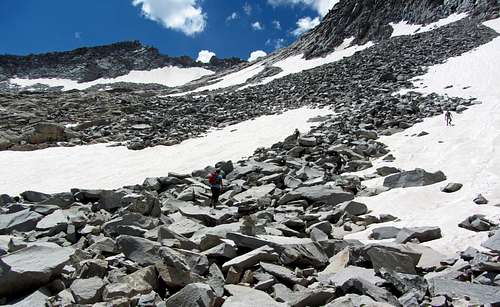
![Boulder fields between Daly & K2]() Up we go through the boulders …
Up we go through the boulders …![Brandon descending K2]() … towards some steeper terrain on our way up to K2.
… towards some steeper terrain on our way up to K2.![Scramble to K2]() Boulder field scramble
Boulder field scramble![Wildflowers below K2 boulderfield]() Wildflowers below K2 boulder field
Wildflowers below K2 boulder field
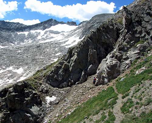
Shortly after this point the trail ended. Since I knew we didn’t want to lose too much elevation as we went through the boulder fields and snowfields to the south, we tried staying high at first, but when James ran into some 4th/5th class walls we were forced to descend. Most of the snow had melted out, but there were three or four places where we had to cross the snow, and as we progressed each snowfield became steeper. James and Serena walked over one 50-degree snow slope that gave me the willies (it appeared that a slip would send someone rocketing down towards some boulders a couple hundred feet below), so Kendrick and I decided to climb some 4th class rock to the west instead. Kendrick went ahead of me, and after some deliberation about the best and least risky line to follow up the smooth rock, I heard some crashing noises a few dozen yards to the north.
![Mount Daly]() Mount Daly Mount Daly | ![Clark Peak]() Clark Peak Clark Peak | ![Maroon Bells]() Maroon Bells Maroon Bells | ![Snowmass Mountain]() Snowmass Mountain Snowmass Mountain |
|---|
![K2 boulderfield]() Stormclouds brewing over K2
Stormclouds brewing over K2
Following Batman’s advice, I’m always mindful of my surroundings (hence my decision not to wear a helmet on this route, which I may get criticized for, but when the rock is solid, you’re aware of what’s going on above you, and it’s not technical climbing, I don’t see the need for it), so as a precaution I tucked myself up against the rock wall and waited to see what would happen. Off a couple dozen feet to the side, four microwave-sized boulders came flying past, which made me quite nervous. They were big enough that a helmet wouldn’t have done anything to help if I’d been struck by one. Shortly thereafter, I saw a climber hopping down the steep fourth class terrain like he was on an easy trail. He asked me if I was going for the top, and I admitted that since it was late and I wasn’t feeling great I would probably call it good at K2. I politely asked him to be more mindful of other climbers when going down routes like this, at which point he offered a quick apology. He then bounded down the snow back towards the Daly saddle.
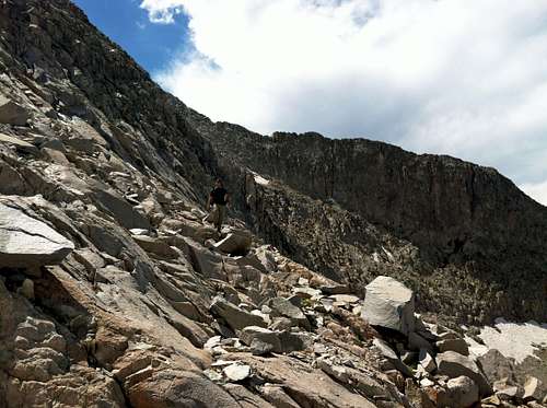
![James on K2]() James on some class 4 terrain near the top of K2
James on some class 4 terrain near the top of K2
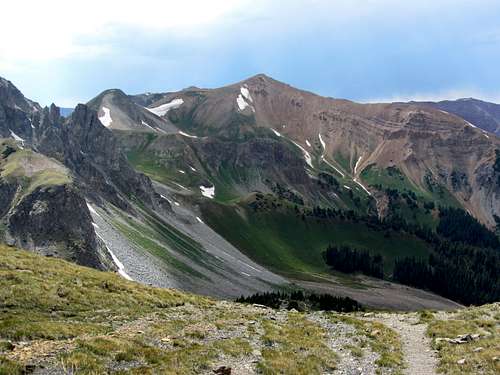
The route from the saddle up around to K2 likely can be kept at class 2 (off-trail boulder hopping) if you continue south far enough, but since it was late and we wanted to save time, we opted to cut west towards K2 sooner over some easy class 3 terrain. After cresting some boulders I finally made out K2 in the distance (from this point it looked very docile, but I knew that the boulder field narrowed on the way up, giving way to some very exposed cliffs near the top), and I spotted the others resting at various spots along the way. At this point an ominous grayish-black cloud approaching from the west demanded our attention. James had already looked ahead a bit from his perch closer towards K2, so he yelled out to inform us that he was confident the storm would clip us, but that we should just hunker down in our rain gear until it passed.
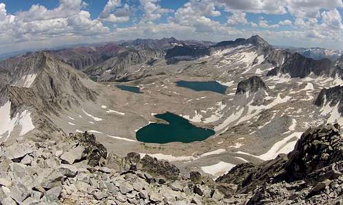
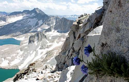
![Pierre Lakes Basin]() Pierre Lakes Basin
Pierre Lakes Basin![Wildflowers on northeast ridge]() A resilient wildflower near K2
A resilient wildflower near K2
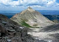
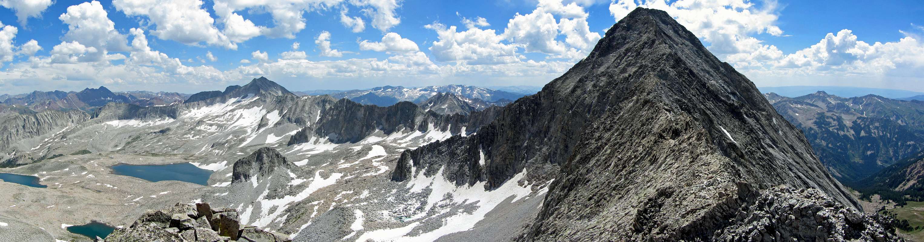
After a few drops of rain, the dark clouds finally gave way to clear skies, so we continued on. Upon arriving at what from below looked like just a little knob, the boulders gave way to some spectacular cliffs dropping into Pierre Lakes Basin to the south and Capitol Lake to the north. The Maroon Bells were visible to the south as well as the nasty ridge leading from Capitol Peak to Snowmass Mountain, but Capitol was still hiding behind K2. James went straight up the east side of K2 without any problems, but the rest of us decided to take an easier route around the north (right) side before continuing to the top. Some exposed class 4 moves were required for this, but I thought it was easy. Soon after this we arrived at the 13,664-foot point. From here the view of Capitol Peak is simply awe-inspiring. The only other comparable vantage points I’ve been to are at the top of the Trough on Longs Peak looking west across Glacier Gorge at the peaks on the other side, and looking towards the Grand Teton to the north from the summit of Middle Teton.
![]()
K2 panorama
![View north from K2]() Capitol Lake far below to the north
Capitol Lake far below to the north
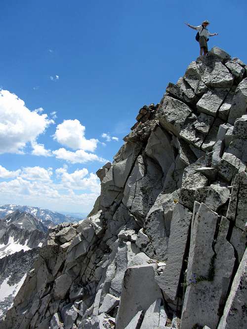
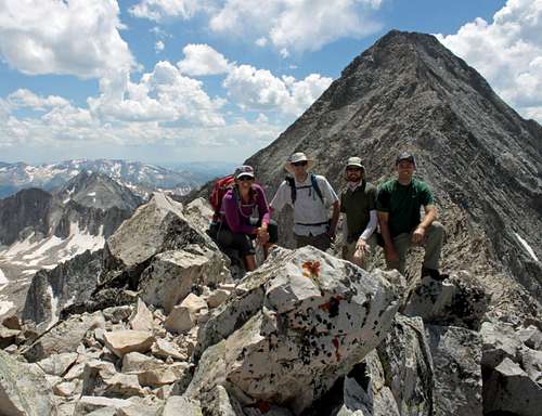
Despite the fact that I had spent years looking forward to trying the Knife Edge and had wanted to summit Capitol Peak more than any other peak, I knew that it would not happen today. Even though I could have continued on to the summit (from here, it looked like you could reach out and touch it, even though it was still half a mile away), the end goal was the trailhead, and I knew I didn’t have enough energy to reach both. My nausea had prevented me from eating enough, and to add to my giant blisters and altitude sickness this was also causing my legs to cramp up. Basically, it was a simple choice for me to say no, since doing my hardest scramble to date while feeling the worst I’d ever felt on a mountain was not a good combination. James and Serena still wanted to continue on, and I would have been glad to wait for them, but when Kendrick chimed in that he too was running low on energy and they figured out how long it would still take to get to the summit and back, they decided to call it good at K2 as well. We took consolation in the fact that it had already been a very fun and scenic hike, and that James and Kendrick had actually hiked higher than they ever had before (their previous highpoint was Kings Peak at 13,528 feet). Besides, even though the skies looked relatively clear, it was already 2 pm, and the previous storm clouds had formed so quickly that there were no guarantees the same thing wouldn’t happen again after continuing across the northeast ridge, next time accompanied by lightning.
![Hiking group at K2]() Group photo with Capitol Peak in the background
Group photo with Capitol Peak in the background
The hike back to Kendrick’s truck was pretty easy-going, and with help from the great scenery and Kendrick and I quoting goofy movies the whole way down, it went quite quickly, despite the long distance. My heels protested for each little section where we had to regain elevation though, even when it was just a few vertical feet. My hot, sweaty feet made it hard to tell exactly at what point in the day my blisters burst, but later at the hotel after peeling my boots off I saw that by the end of the day the boots had began cutting into the soft skin underneath, leaving a nice bloody mess near the back of both feet (I refrained from taking a picture though, since I think it’s nicer looking at pictures of mountains). I’ve tried everything from moleskin to duct tape to medical tape to special antibiotic ointment band-aids, with wicking socks and broken-in boots for good measure, but nothing has worked so far. James said he does quite well in trail runners, so I may look into getting less heavy boots in the future, or I might even try using those pills that prevent you from sweating as much (I’d have to check on the side effects though).
![Capitol Peak north face]() Imposing north face of Capitol Peak
Imposing north face of Capitol Peak![Capitol Peak over Capitol Lake]() Hiking back down to Capitol Lake
Hiking back down to Capitol Lake![Brown Bear]() Brown bear sighting from road near trailhead
Brown bear sighting from road near trailhead
As we made our way back down the mountain, I began to feel better and better (well, everywhere except my feet), and felt good about my decision to turn back. If anything, I had proved to myself (and my wife, who was skeptical until this day) that I indeed could make the smart choice and turn back from a summit attempt when for whatever reason it was not prudent (this day we started too late, and I just didn’t bring my "A" game), even after looking forward to it for so long. Going down, we encountered more hikers on their way up, all of whom were backpacking at Capitol Lake before attempting the peak, and they were impressed that we had even made it to K2 as a day hike. Capitol Peak definitely pushes the limit of what an average hiker can do in a single day, and even though a seven year old has climbed it, along with several other people this summer finishing their 14er lists, it is not a mountain to be taken lightly. If I get a rematch and finally summit this monster of a peak in a single day (I’m a day hiker at heart, and backpacking doesn’t really interest me), I’ll appreciate it that much more since I failed the first time.
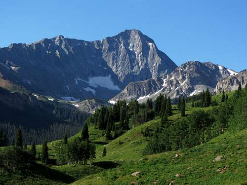
![Beautiful Capitol Peak]() Someday I hope for a rematch with this awesome peak
Someday I hope for a rematch with this awesome peakCapitol Peak Stats
DISTANCE:
16 miles roundtrip
CAPITOL CREEK TRAILHEAD:
9,450 feet
K2 ELEVATION:
13,664 feet
ELEVATION GAIN:
4,750 feet
DIFFICULTY (Stopping at K2):
Class 3+
TIME:
12 hours
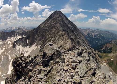
![K2 and Capitol Peak]() We were only half a mile from our goal ...
We were only half a mile from our goal ...![Capitol Peak]() ... but my attempt on the Knife Edge of Capitol Peak's Northeast Ridge would have to wait for another time.
... but my attempt on the Knife Edge of Capitol Peak's Northeast Ridge would have to wait for another time.Continued in Part II ...


Comments
Post a Comment