|
|
Mountain/Rock |
|---|---|
|
|
46.23500°N / 11.59577°E |
|
|
Trentino Alto-Adige |
|
|
Hiking, Mountaineering, Scrambling, Skiing |
|
|
Spring, Summer, Fall |
|
|
8182 ft / 2494 m |
|
|
Overview
Cauriòl 2494 m
Cauriòl 2494 m is a mountain belonging to the Northern sector of the Lagorai Group and located at the head of the Val Sàdole, between the Val Vanoi and the Val di Fiemme in Eastern Trentino. It is a beautiful mountain that forms a mighty rocky bastion together with the Cauriòl Piccolo 2396 m, from which it is separated by a high saddle called Selletta Cartéri. These two peaks are among the best known in the Lagorai chain in reason of the battles that took place on these summits during the WWI (First World War). The mountain can be climbed through two different standard routes, the Italian Normal and the Austrian Normal, that converge to the Selletta Cartéri. The Italian route skirts counterclockwise the Cauriòl Piccolo and leads inside the Busa della Neve, which is climbed straightforward to the Selletta Cartéri. The Austrian route on the contrary skirts the CauriòI Piccolo in a clockwise direction. It's longer, less steep and very well paved with flat stones, but nowaday there are some short stretches on blocks where the war-pave has been damaged. In this page it will be reported the crossing of the Cauriòl with the ascent on the Via Italiana and the descent on the Via Austriaca, an advisable and very interesting ring itinerary through the places of the Great War.
Another reason to climb the Cauriòl is the wide panorama visible from the summit. On clear days you can see a great view that literally leaves you speechless. A 360 degree turn of the horizon over all the most important peaks of the district, with a view that spans from the close peaks of the Lagorai chain, such as Cima d'Asta and Cardinal, to the Western Dolomites, with the groups of Catinaccio, Latemar, Sassolungo, Sella, Marmolada and Pale di San Martino, from the Adamello, Presanella and Brenta Dolomites groups to the South-West, to the Ortles-Cevedale, Alpi Venoste and Alpi Breonie.

Il Cauriòl 2494 m è una montagna appartenente al settore settentrionale del Gruppo del Lagorai e situata alla testata della Val Sàdole tra la Val Vanoi e la Val di Fiemme nel Trentino orientale. È una bella montagna rocciosa che insieme al Piccolo Cauriòl 2396 m, da cui è separata da un'alta sella chiamata Selletta Cartéri, forma un imponente bastione roccioso. Queste due cime sono tra le più conosciute della catena del Lagorai a causa delle battaglie che si sono svolte su queste cime durante la Prima Guerra Mondiale. La montagna può essere scalata attraverso due diversi percorsi standard, la Normale italiana e la Normale austriaca che convergono alla Selletta Cartéri. La via italiana costeggia in senso antiorario il Cauriòl Piccolo e conduce nella Busa della Neve, che sale direttamente alla Selletta Cartéri. La via austriaca al contrario costeggia il Piccolo Cauriò in senso orario. È più lunga ma meno ripida e pavimentata con piatti lastroni nella prima parte, ma in alcuni brevi tratti sui blocchi il parapetto di guerra è stato danneggiato. In questa pagina verrà riportata la traversata del Cauriòl con la salita lungo Via Italiana e la discesa lungo la Via Austriaca, un itinerario ad anello consigliabile e molto interessante attraverso i luoghi della Grande Guerra.
Un altro motivo per scalare il Cauriòl è l'ampio panorama visibile dalla cima. Nelle giornate limpide è possibile godere una splendida vista che lascia letteralmente senza parole. Un giro di orizzonte a 360 gradi su tutte le vette più importanti del comprensorio, con una vista che spazia dalle cime vicine della catena del Lagorai, come Cima d'Asta e il Cardinale, alle Dolomiti occidentali, con i gruppi del Catinaccio, Latemar, Sassolungo, Sella, Marmolada e Pale di San Martino, dai gruppi Adamello, Presanella e Dolomiti di Brenta a Sud-Ovest, fino all'Ortles-Cevedale, Alpi Venoste e Alpi Breonie.

|

|
Getting There
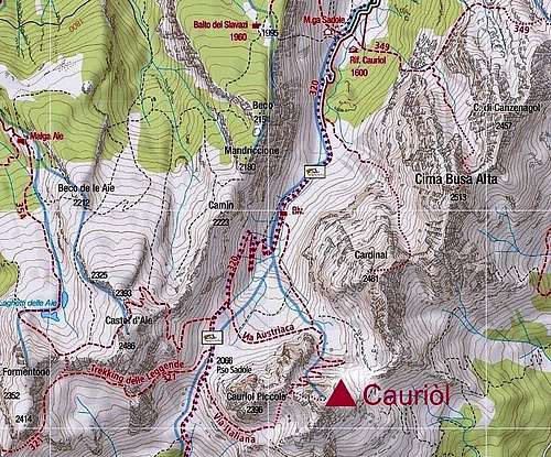
Cauriòl can be reached from the Rifugio Cauriol, located in the Val di Sadole, a side road of the Val di Fiemme. The starting point to climb is the village of Ziano di Fiemme 980 m.
Another longer approach is along the high valley of the Vanoi, through the path that starts from Rifugio Refavaie 1116 m, accessible by road from Caoria
Road access to Ziano di Fiemme
- coming from Trento: follow the Brennero Motorway towards North, exit Egna-Ora and take the road S51 towards Val di Fassa, getting to Cavalese and Ziano di Fiemme (37 km from Egna-Ora)
- coming from Bolzano: follow the Brennero Motorway towards South, exit Egna-Ora and take the road S51 towards Val di Fassa, getting to Cavalese and Ziano di Fiemme

|

|
Once reached Ziano di Fiemme, leave the main road, turn to right to cross the Avisio stream and after passing the hamlet of Bosin, continue to drive on the paved road inside the wood of firs (signpost for the "Rifugio Cauriol"). After passing a bar that closes the road in winter, continue on the road at first paved, then unpaved (but always well traveled by normal vehicles) to the meadows where arise the Rifugio Cauriol and the Malga Sadole (1594 m, parking).
Cauriòl traverse across Val Sadole
Cauriòl traverse across Val Sadole
Summit height: 2494 m
Difficulty: EE
Difference in level: 900 m
Exposition: different
Starting point: Rifugio Cauriòl parking lot
An easy and excellent panoramic route to get the summit of Cauriòl. An advisable trips across the WWI remains. The views from the top are breathtaking.
From the parking lot near the refuge continue straight on the mule track (path n. 320), entering the wood. After passing a wooden walkway, the route reachs the beautiful meadow of Pian delle Maddalene (30 minutes from the shelter), where there is also a small shelter on a tree. At the next junction ignore the path on the left to the Forcella del Cardinal; arriving in front of a small water reservoir, on the right the path continues and start to climb gently always on a good trail, in the direction of Passo Sedole. Further on, on the left, you will see on the left the valley between the Cardinàl and Monte Cauriòl, where it runs clearly obvious the first part of the route "Via Austriaca".
Un percorso panoramico facile ma remunerativo per raggiungere la vetta del Cauriòl. E' un interessante viaggio attraverso la Grande Guerra. Panorama mozzafiato dalla vetta.
Dal parcheggio vicino al rifugio proseguire dritto sulla mulattiera (sentiero 320), entrando nel bosco. Dopo aver attraversato una passerella di legno, il sentiero raggiunge il bellissimo prato di Pian delle Maddalene (a 30 minuti dal rifugio), dove si trova anche un piccolo rifugio per avvistamento su un albero. Al successivo incrocio ignorare il sentiero a sinistra per la Forcella del Cardinale. Arrivato nei pressi di un piccolo serbatoio d'acqua, il buon sentiero continua sulla destra e inizia a salire dolcemente in direzione del Passo Sedole. Più avanti, sulla sinistra, vedrete la valle tra il Cardinàl e il Monte Cauriòl, dove sale la prima parte del percorso "Via Austriaca".

|

|
With a slight ascent and some hairpin bends the trail gets the junction between the two routes: on the left the Austrian route and on the right the Italian one (signpost to Passo Sadole). Continue to the right along the Italian road, passing the junction to Monte Castel de le Aie. You arrive at an altitude of 2057 meters where there are conspicuous and well-preserved remains of a military barricade. Ignore the junction on the right and continue straight about 10 minutes to reach Passo Sadole 2066 m, where a wooden crucifix is placed. The itinerary continues crossing a steep slope and bypassing the Cauriòl Piccolo 2393 meters. We arrive at a crossroads where a large boulder with the signpost to Cauriòl. With a steep ascent the route enters the hidden Busa della Neve, with the Cauriòl Piccolo on the left and the Selletta Cartéri in front of.
Con una leggera salita ed alcuni tornanti il sentiero raggiunge il punto di incontro tra i due itinerari esistenti per salire in vetta: a sinistra la Via Austriaca e a destra la Via Italiana (segnavia per Passo Sadole). Proseguire sulla destra lungo la Via Italiana, superando il bivio per Monte Castel de le Aie. Si arriva ad un'altitudine di 2057 metri dove si possono ammirare resti ben visibili e ben conservati di una caserma militare. Ignorare il bivio a destra e proseguire diritto per circa 10 minuti per raggiungere Passo Sadole 2066 m, dove si trova un crocifisso in legno. L'itinerario continua attraversando un ripido pendio e aggirando il Piccolo Cauriòl 2393 m. Si arriva ad un bivio con un grande masso recante la tabella per il Cauriòl. Con una ripida salita il percorso entra nella Busa della Neve, con il Cauriòl Piccolo a sinistra e la Selletta Cartéri di fronte.

|

|
The path crosses the gravel ground and then continues along the gully on a very steep slope of stones and soil, getting the high Selletta Cartèri 2343 m, carved between Monte Cauriol to the right and the rugged ridge of Piccolo Cauriol to the left. Here our itinerary joins the itinerary of the Austrian route that climbs from the opposite side. To the right we see the summit of Monte Cauriol rather nearby. From the saddle turn to right and climb up the rocky Western slope of Cauriol on a signposted war path and with some very easy scrambling. There are some different variants, anyhow all the routes are easy and converge near the summit at 2494 m, marked by a cross and various memorial plates. The panorama is unforgettable!
Il sentiero attraversa il ghiaione per poi proseguire lungo il canalone su un pendio molto ripido di sassi e terra, raggiungendo l'alta Selletta Cartèri 2343 m, che si apre tra il Monte Cauriol a destra e il cospicuo crinale del Piccolo Cauriol a sinistra. Qui il nostro itinerario converge con la Via Austriaca che sale dal lato opposto. A destra la cima del Monte Cauriol appare piuttosto vicina.
Dalla sella svoltare a destra e risalire il pendio roccioso occidentale del Cauriol su un sentiero di guerra segnalato e con alcune roccette molto facili. Ci sono diverse varianti, comunque tutti i percorsi sono facili e convergono vicino alla cima a 2494 m, contrassegnata da una croce e da varie targhe commemorative. Il panorama è indimenticabile!


|

|
The path is always well marked by red-white signs, but in some places the pavement no longer exists and you move along large boulders. You reach the end of the gully and oblique to the left passing near the "Pozzo Austriaco" (Austrian Well). After a flat stretch you reach again the junction with the "Via Italiana" and you find yourself on the path n. 320, which leads back to the Baita Monte Cauriol.
Il sentiero è sempre ben segnalato con i segni bianco-rossi, ma in alcuni punti l'antica pavimentazione non esiste più e ci si muove tra grandi massi. Si raggiunge la fine del canalone e si obliqua a sinistra passando vicino al "Pozzo Austriaco". Dopo un tratto pianeggiante si raggiunge nuovamente l'incrocio con la "Via Italiana" e ci si ritrova quindi sul sentiero n. 320, che riporta alla Baita Monte Cauriol.

|

|
Red Tape
No fees no permits required
Hiking and scrambling grades
T - Turistico (Tourist): Itineraries on wide, clear and well worn paths, sometimes on mule tracks or gravel roads. The routes are never exposed, don't give any orientation problems and don't exceed 2500 meters of altitude. Suitable also for children.
E - Escursionisti (Hikers): Itineraries on marked trails, even narrow and with possible steep and impervious sections. They are never exposed and don't give any orientation problems. They can tread different kinds of ground, such as forests, gravel, meadows, pastures, easy rocks, etc.). They form the majority of the trails that wind up in the mountains and require a certain habit to walk; you need equipment suitable for the altitude and resistant footwear with soles suitable for rough terrain.
EE - Escursionisti Esperti (Experienced Hikers): Itineraries for hikers with experience and good knowledge of the mountain. Some of these paths may have exposed sections, however brief, which require firm foot and no dizziness. They require the ability to adapt to particular terrain, such as steep grassy slopes or stretches of rocks with difficulties that can reach the 1st degree of the UIAA scale. They can also reach high altitudes (3000 m or more). Sometimes they may include unmarked sections, requiring a good sense of orientation. Snow slopes are possible, however which can be overcome without specific mountaineering gear (rope, harness, crampons, ice-axe).
EEA - Escursionisti Esperti con Attrezzatura (Experienced Hikers with equipment - The same as EE, in addition these routes require the use of via ferrata equipment (lanyards, harness, carabiners, heat sink, helmet). This kind of itineraries range from the trails with short easy and not much exposed sections, previously equipped with fixed ropes and iron pegs, to the true and more difficult Via Ferratas climbing on rocky walls or on aerial ridges and ledges, previously equipped with long stretches of iron ropes, iron steps, ladders without which proceeding would constitute a real climbing. It is necessary to know how to use the technical equipment and have a certain habit of exposure and mountaineering terrains.
The WWI on Monte Cauriòl

The Cauriòl is famous in reason of the events of the First world war (1915-1918) between the Italian and the Austro-Hungarian armies. The mountain was in the hands of the Austro-Hungarian troops which considered it absolutely strategic for the control of the territory because of its dominant position. Obviously the Italian command wanted to conquer this peak. At the beginning the Italian troops attempted to conquer the mountain by climbing it, but all were massacred. Only on August 27, 1916, at about 7:50 pm, two platoons of Alpini, also thanks to the artillery coverage, managed to conquer the summit, capturing 17 enemies and a large quantity of weapons and war material. This was the fourth attempt, after the Austro-Hungarians rejected three Italian assaults. During the conquest, the second lieutenant Attilio Carteri of the 65th company of the Feltre mountain battalion perished. Successively the Austro-Hungarians renounced to reconquer the summit, and the Italians managed to conquer the saddle fork, but did not go further along the Fiemme valley. Only in October 1917 when the route of Caporetto took place the Italians abandoned this summit, which had involved about 10,000 Italian soldiers fallen (assumed to be the same number by the enemy), both during the war-action and the "white death".
Il Cauriòl è famoso per gli avvenimenti della Prima Guerra Mondiale (1915-1918) tra gli eserciti italiano e austro-ungarico. La montagna era nelle mani delle truppe austro-ungariche che la consideravano assolutamente strategica per il controllo del territorio a causa della sua posizione dominante. Ovviamente il comando italiano voleva conquistare questa cima. All'inizio le truppe italiane tentarono di conquistare la montagna salendola, ma furono tutti massacrati. Solo il 27 agosto 1916, intorno alle 19:50, due plotoni di Alpini, anche grazie alla copertura di artiglieria, riuscirono a conquistare la vetta, catturando 17 nemici e una grande quantità di armi e materiale bellico. Questo fu il quarto tentativo, dopo che gli austro-ungarici avevano respinto tre assalti italiani. Durante la conquista, perirono il sottotenente Attilio Carteri della 65a compagnia del battaglione di Feltre. Successivamente gli Austro-ungarici rinunciarono a riconquistare la vetta e gli Italiani riuscirono a conquistare la forcella, ma non andarono oltre lungo la valle di Fiemme. Solo nell'ottobre del 1917, quando ebbe luogo la sconfitta di Caporetto, gli Italiani abbandonarono questa cima, che aveva coinvolto circa 10.000 soldati italiani caduti (più o meno lo stesso numero in campo nemico), sia durante l'azione bellica che nella "morte bianca".
When to Climb
Mountaineering: from June to October
Ski-mountaineering: March, April
Where to stay
Various possibilities in Ziano di Fiemme.
Bibliography


"Lagorai Cima d'Asta" by Mario Corradini - Collana Guide Monti d'Italia, Milano 2006 - a complete and exaustive guide to hiking and climbing into the most large wilderness-area of Trentino. Edited by the Touring Club Italiano in collaboration with the Club Alpino Italiano
Maps
Val di Fiemme-Lagorai-Latemar - Tabacco 14 1:25000
Meteo Forecast